6. ZONING - PART OF 7069 FOURTH LINE ROAD AND 2165 CALLENDOR ROAD ZONAGE - PARTIE DU 7069, CHEMIN
FOURTH LINE ET 2165, cHEMIN CALLENDOR
|
COMMITTEE RECOMMENDATION
That Council approve an amendment to the former
Township of Rideau Zoning By-Law to change the zoning of part of 7069 Fourth
Line Road and 2165 Callendor Road from General Rural (A2) to a Special A2 Zone
(A2-xx) and from Environmental Protection (EP) to a Special EP Zone (EP-xy) as
shown on Document 1 and as detailed in Document 2.
Recommandation du comitÉ
Que le Conseil
municipal approuve une modification au Règlement de zonage de l’ancien Canton
de Rideau afin de changer la désignation de zonage d’une partie du 7069, chemin
Fourth Line et du 2165, chemin Callendor de Zone rurale générale (A2) à Zone A2
spéciale (A2-xx) et de Zone de protection de l’environnement (EP) à Zone EP
spéciale (EP-xy), tel qu’il est indiqué dans le Document 1 et expliqué en
détail dans le Document 2.
Documentation
1.
Deputy City Manager, Planning and Growth Management report
dated 1 May 2006 (ACS2006-PGM-APR-0103).
Report
to/Rapport au :
Agriculture and Rural Affairs Committee
Comité de l'agriculture et des questions
rurales
and Council / et au Conseil
Submitted by/Soumis par : Ned Lathrop,
Deputy City Manager/Directeur municipal
adjoint,
Planning and Growth Management / Urbanisme
et Gestion de la croissance
Contact Person/Personne ressource : Grant Lindsay,
Manager / Gestionnaire
Development Approvals / Approbation des
demandes d'aménagement
(613) 580-2424 x13242,
Grant.Lindsay@ottawa.ca
|
SUBJECT: |
ZONING - Part of 7069 Fourth Line road
and 2165 callendor road (FILE NO. D02-02-06-0038) |
|
|
|
|
OBJET : |
ZONAGE - PARTIE
DU 7069, CHEMIN FOURTH LINE ET 2165, cHEMIN CALLENDOR |
REPORT RECOMMENDATION
That the Agriculture and Rural Affairs
Committee recommend Council approve an amendment to the former Township of
Rideau Zoning By-Law to change the zoning of part of 7069 Fourth Line Road and
2165 Callendor Road from General Rural (A2) to a Special A2 Zone (A2-xx) and
from Environmental Protection (EP) to a Special EP Zone (EP-xy) as shown on
Document 1 and as detailed in Document 2.
RECOMMANDATION DU RAPPORT
Que le Comité de l’agriculture et des questions
rurales recommande au Conseil d’approuver une modification au Règlement de
zonage de l’ancien Canton de Rideau afin de changer la désignation de zonage
d’une partie du 7069, chemin Fourth Line et du 2165, chemin Callendor de
Zone rurale générale (A2) à Zone A2 spéciale (A2-xx) et de Zone de protection
de l’environnement (EP) à Zone EP spéciale (EP-xy), tel qu’il est indiqué dans
le Document 1 et expliqué en détail dans le Document 2.
BACKGROUND
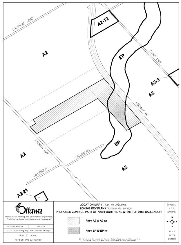
The site is
located at 7069 Fourth Line Road and 2165 Callendor Road, which is located
south of the Village of North Gower and abuts Highway 416. The southeastern
portion of the site abuts an unopened road allowance.
The subject lands are currently one parcel. The
Committee of Adjustment approved the site for a severance on January 19, 2006
to create a lot for a surplus farm dwelling. The assigned municipal address of
the retained parcel will be known as 7069 Fourth Line Road and 2165 Callendor
Road. The assigned municipal address of the proposed severed parcel to be
created is 7057 Fourth Line Road.
The subject area is approximately 32 hectares in area.
The lands are vacant and agricultural. The parcel is L-shaped with 135 metres
of frontage along Fourth Line Road, 833 metres abutting Highway 416, and 242
metres along Callendor Road (see Document 1). The surrounding area is
agricultural and rural in nature. The Cranberry Creek Municipal Drain is located
to the rear of the property and the Trans Canada Pipeline runs through the
property in an east-west direction.
DISCUSSION
City Council Approved Official Plan
The City Council Approved Official Plan, designates the predominate
portion of the site as Agricultural Resource and the remaining portion is
designated as Significant Wetland. The Agricultural Resource designation ensures agricultural land is
protected from loss to other uses and ensures uses, which would conflict with
agricultural operations are not established in productive farming areas. No
development is permitted within Significant Wetlands. The Farm Consolidation -
Surplus Dwelling policy states that the vacant agricultural parcel which is
created be rezoned to prohibit residential use.
Former Regional Official Plan
In the former Regional Official Plan, most of
the site is designated as Agricultural Resource with a small portion designated
as Significant Wetland. The intent of the Agricultural
Resource designation is to protect major areas of agricultural production and
other lands suitable for agriculture from loss to other uses and ensure uses
that would result in conflicts with agricultural operations are not established
in productive farming areas. Development and site alteration is not permitted
within Significant Wetlands. Farm severances are permitted in cases such as
dwelling made surplus through farm consolidation, creating one lot for a
farmer's retirement, and to create a new holding.
Former Township of Rideau Official Plan
In the former Township of Rideau Official Plan,
the site is predominately designated as Agricultural Resource and a small
portion near Cranberry Creek as Hazard Land. The predominant use of land within
the Agricultural Resource designation is agriculture and farm related uses. A
farmhouse made surplus through farm consolidation is permitted. If the farm
consolidation is not contiguous, the residual of the new farm holding must be
rezoned to prohibit the construction of a new residence.
Proposed Zoning By-law Amendment
The site is zoned as A2 (General Rural) and EP
(Environmental Protection). The application is to rezone the subject area to
prohibit construction of a residential dwelling as a condition imposed by the
Committee of Adjustment.
The lands will be rezoned from A2 to a Special A2
Zone (A2-xx) prohibiting residential uses and setting the lot frontage minimum
to 135 metres, as the site does not meet the 150 metres lot frontage
requirement of the General Rural Zone, and from EP to a Special EP Zone (EP-xy)
to recognize that 7069 Fourth Line Road and 2165 Callendor Road are under the
same ownership and should be considered one lot for the purposes of determining
lot frontage and lot area for the A2-xx zoned lands.
The Zoning By-law amendment is appropriate because
it will protect agricultural land from residential development. The City
Council Approved Official Plan, former Regional Official Plan, and the former
Township of Rideau Official Plan allow for farm related severances as along as
the remnant agricultural parcel is rezoned to prohibit residential use.
ENVIRONMENTAL IMPLICATIONS
Unstable slopes and organic soils were identified on Schedule K, Environmental Constraints, on a small portion of the site to the northeast and the Cranberry Creek Municipal Drain is located to the rear of the property. The Zoning By-law amendment would prohibit future residential development and continue the agricultural operations on-site. No concerns were raised by staff or the Rideau Valley Conservation Authority.
RURAL IMPLICATIONS
The rezoning to a Special A2 Zone and a Special EP Zone designation conforms to surrounding land uses and Official Plan policies.
CONSULTATION
Notice of this application was
carried out in accordance with the City’s Public Notification and Consultation
Policy. The Ward Councillor is aware of
this application and the staff recommendation.
The City did not receive any negative comments or opposition to this
application.
FINANCIAL IMPLICATIONS
APPLICATION PROCESS TIMELINE STATUS
This application was processed by the "On-Time
Decision Date" established for the processing of Zoning By-law Amendment
applications.
SUPPORTING DOCUMENTATION
Document 1 Location Map
Document 2 Details
of Recommended Zoning
DISPOSITION
Corporate Services Department, City
Clerk's Branch to notify the owners (Tim and Marc Woerlen, 2352 Dilworth Road,
Kemptville, ON K0G 1J0), the applicant
(Tim Woerlen, 2153 Lockhead Road, RR#2, North Gower, ON K0A 2T0), Signs.ca, 866 Campbell Avenue,
Ottawa, ON K2A 2C5, and Ghislain
Lamarche, Program Manager, Assessment, Financial Services Branch (Mail Code: 26-76)
of City Council's decision.
Planning
and Growth Management Department to prepare the implementing by-law, forward to
Legal Services Branch and undertake the statutory notification.
Corporate
Services Department, Legal Services Branch to forward the implementing by-law
to City Council.
LOCATION MAP Document
1
DETAILS OF RECOMMENDED ZONING Document 2
The subject lands, part of 7069 Fourth Line Road and 2165 Callendor Road, as shown on Document 1 will be rezoned from A2 to A2-xx and EP to EP-xy and used in accordance with the following provisions:
A2-xx zone
1. No residential uses are permitted
2. despite subsection 3(13) the land zoned A2-xx and the adjoining land zoned EP-xy and under the same ownership are considered one lot for the purposes of determining lot frontage and lot area.
3. Despite sub-clause 23(2)(b)(ii) the minimum required frontage for other uses is 135 metres.
EP-xy
1. despite subsection 3(13) the land zoned EP-xy and the adjoining land zoned A2-xx and under the same ownership are considered one lot for the purposes of determining lot frontage and lot area for the A2-xx zoned lands.