Report
to/Rapport au :
Planning and Environment Committee
Comité de l'urbanisme et de
l'environnement
and Council / et au Conseil
Submitted by/Soumis par : Ned
Lathrop, Deputy City Manager /
Directeur municipal adjoint
Planning and Growth Management / Urbanisme et Gestion de la croissance
Contact Person/Personne ressource : Grant Lindsay,
Manager / Gestionnaire
Development Approvals / Approbation des
demandes d'aménagement
(613) 580-2424 x13242,
Grant.Lindsay@ottawa.ca
|
SUBJECT: |
ZONING – 1776 mAPLE gROVE rOAD (Formerly
5831 Hazeldean road) (file # D02-02-04-0132) |
|
|
|
|
OBJET : |
ZONAGE - 1776,
chemin maple grove (anciennement 5831, chemin hazeldean |
REPORT RECOMMENDATION
That the Planning and
Environment Committee recommend Council approve an amendment to the former
Township of Goulbourn Zoning By-Law to change the zoning of 1776 Maple Grove
Road (formerly 5831 Hazeldean Road) from A1 (Agricultural Zone), R2-T1
(Residential Type 2 Temporary Use) and EPA (Environmental Protection Zone) to R1-__ (Residential Type 1 Special Exception
Zone), NEA-1 (Natural Environment Area Special Exception Zone), and PR (Parks
and Recreation Zone) to permit residential development as shown and detailed in
Document 4.
RECOMMANDATION DU RAPPORT
Que le Comité de l’urbanisme
et de l’environnement recommande au Conseil d’approuver une modification au
Règlement de zonage de l’ancien Canton de Goulbourn afin de changer la
désignation de zonage du 1776, chemin Maple Grove (anciennement le
5831, chemin Hazeldean) de A1 (zone agricole), R2-T1 (zone résidentielle
de type 2, utilisation temporaire) et EPA (zone de protection de l’environnement)
à R1-__ (zone résidentielle de type 1 assortie d’une exception spéciale), NEA-1
(zone de secteur écologique naturel assortie d’une exception spéciale) et PR
(zone de parcs et loisirs) afin de permettre un aménagement résidentiel, tel
qu’il est indiqué et expliqué en détail dans le document 4.
BACKGROUND
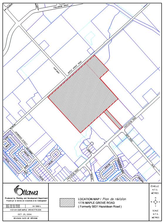
The property is 41.18 hectares in size and is located within the southeast and
southwest quadrants of the Kanata West Concept Plan area at 1776 Maple Grove
Road (formerly 5831 Hazeldean Road) as shown in Document 1. Maple Grove
Road forms the northern property line while the southern property line is
parallel to Hazeldean Road. The lower Poole Creek Valley crosses
the south east section of the site.
The amendment proposes to change the zoning
from the existing Agriculture Zone (A1), Residential Zone (R2-T1) and
Environmental Protection Area Zone (EPA) to a Special Exception Residential
Zone, a Parks and Recreation Zone (PR) and a Natural Environment Area Zone
(NEA-1). The purpose of the rezoning is to permit a flexible range of
ground-oriented residential dwelling types which include single-detached,
semi-detached and street townhouses. A number of special standards are also
being proposed as part of this amendment for building setbacks, lot coverage
and driveway and parking provisions.
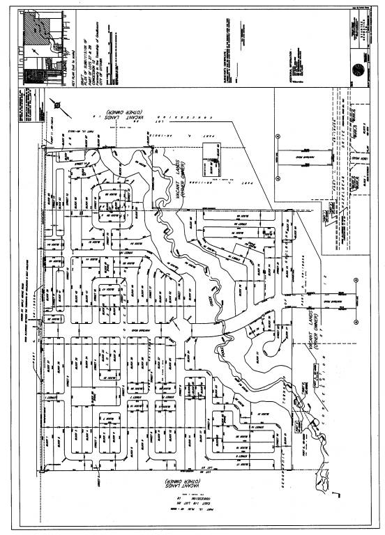
A
companion subdivision application proposes to subdivide the property to permit
approximately 850 dwelling units. The dwelling unit breakdown is as follows:
Single-detached
dwellings 500 units
The project yields a gross density of
approximately 20 units per hectare. The
net density is 38 units per hectare excluding parks, the Poole Creek
corridor and municipal roads
The proposal includes four neighbourhood parks
and associated pathway blocks to provide pedestrian connections to the parks
and the Poole Creek Valley. Community access will be provided by the extension
of Huntmar Drive from its terminus at Maple Grove Road south to Hazeldean Road
as shown in Document 3.
DISCUSSION
Policy Framework
The City Council Approved Official Plan designates the property General Urban Area with the Poole Creek corridor designated Major Open Space. The General Urban Area designation permits the development of a full range and choice of housing types. The Official Plan describes Major Open Spaces as “key components of the Greenspace Network, which contributes to the quality of life in neighbouring communities, as well as, the overall integrity of the natural environment”.
Regional Official Plan Amendment 9, adopted by the former Region of Ottawa-Carleton in October 2000 redesignated the subject lands from Agricultural Resource Area to General Urban Area. The lands remain designated Agricultural Resource in the former Township of Goulbourn Official Plan.
In the Kanata West Concept Plan, approved by Council in March 2003,
the lands are shown as “Residential A and B” with the Poole Creek Corridor as
“River/Creek Corridor”. These residential areas are to “permit a range of residential dwelling types in
a transit-integrated and pedestrian friendly environment. Urban residential densities are encouraged throughout these
residential areas. These densities are higher than typical suburban residential
areas and are more in keeping with post-war communities such as Ottawa South
and the Glebe.”
The subject application is in conformity with
the policies associated with the above noted Official Plan designations and the
land use provisions of the Kanata West Concept Plan. This also provides an
opportunity to realize certain design objectives of the Official Plan and the
Kanata West Concept Plan.
Lands within the Kanata West Concept Plan area
require a number of Environmental Assessments (EA’s) related to servicing,
transportation network and creek restoration. These EA’s are nearing
completion. The subject Zoning By-law amendment application will serve to
implement the subdivision by permitting the land uses set out in the draft
plan. It will not in of itself result in development proceeding. Prior to
issuance of building permits the conditions of draft approval will have to be
cleared. A number of the draft conditions require that the subdivision
engineering drawings and reports be finalized in keeping with the final results
of the respective EA’s.
Details of Proposed Zoning
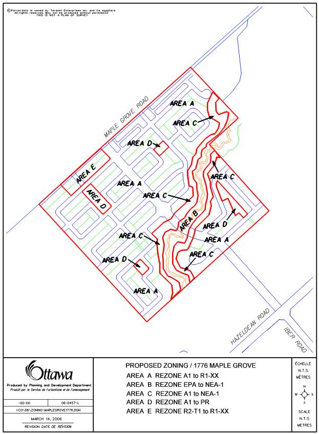
Residential (Area A)
The proponent is requesting that the residential portion of the site be zoned a single zone which permits singles, semis and townhouses as can be seen in Document 4. This approach recently has been considered and approved by Council through the rezoning of the Jackson Trails Subdivision located further to the east along Hazeldean Road, within the former Stittsville Village limits. This approach to residential zoning has also been in place for some time in other areas of the city namely; former Gloucester, Nepean and Kanata.
This approach in
theory would allow for the residential area of the subdivision to be developed
entirely as large lot single detached homes. This would not meet the policies
of the General Urban Area of the City Council Approved Official Plan nor the
intent of the Kanata West Concept Plan both of which encourage denser
development to make efficient use of public infrastructure and encourage
transit use.
The intent of the proponent is, in fact, to have a mix of all three housing types. This is also what was presented to the public in the public meeting and the information and comment session. Staff is recommending approval of this residential zoning request and that a new zone be introduced into the By-law which would permit singles, semis or townhouse providing a density of 29 units per net hectare is achieved. This density is the same as that applied to those areas designated “Developing Communities” in the City Council Approved Official Plan.
The application is also proposing a number of zone provisions which are not standard to the Goulbourn Zoning By-law and represent a further “densification”. Some of the proposed provisions are to accommodate housing products that are unique to the developer and had not been anticipated when the Goulbourn Zoning By-law was formulated. The minimum front yard setbacks being proposed is 3 metres, with rear yards of 6 metres, and exterior side yards of 2.5 metres, and maximum lot coverages of 55% for singles and 65% for townhouses. The proposed by-law provisions also encourage garages to be either flush with the front face of the house or setback further than the house. There are examples of similar zoning provisions in the Zoning By laws of former Gloucester, Nepean and Kanata. This approach to residential zoning with similar zone provisions has been in place in Kanata since the late 1980s.
Reduced setbacks meet the intent of the City Council Approved Official Plan to increase the development density and make more efficient use of serviced urban land. By bringing the buildings closer to the street and creating more street presence these proposed setbacks also fulfill design objectives of the City Council Approved Official Plan. This open flexible zoning approach will also be reflected in the new draft Comprehensive Zoning By-law.
The Kanata West Concept Plan outlines general design principles, as well as, those specific to each land use category. A number of these are implemented through this proposed zoning. This new residential zoning allows for a mix of residential dwelling types, including medium and small lot single-detached and semi-detached houses and townhouses. Improving the streetscape and reducing the need for noise barrier fences along major spine roads is achieved by introducing townhouses on rear lanes and adopting zoning provisions which will allow for wrap around porches into exterior sideyards. A close relationship between the house and street is achieved by reducing frontyard setbacks and encouraging the garages to be either setback from, or flush with the building face. More urban like residential density will also be achieved by including a minimum density requirement similar to that reflected in the Official Plan for “Developing Communities”.
In areas of the city where a similar zoning approach and similar setbacks have been implemented it has generally been successful. The developer has more flexibility in housing form and can react to the changes in the housing market without the need for rezoning. Purchasers have more choices in the model of home that can be placed on the respective lots.
Neighbourhood Parks (Area D)
The subdivision layout includes four small neighbourhood parks. These parks are proposed to be zoned PR (Parks and Recreation) Zone. This would be consistent with the zone which is generally applied to municipally owned parks in the Goulbourn Ward.
Poole Creek Corridor (Area B and C)
The existing zoning which applies to the Poole Creek Corridor is EPA (Environmental Protection Area). In the context of the Goulbourn Official Plan this zone was applied to lands that were in the flood plain. Uses permitted in this zone include farming, forestry, golf course, active park and parking lot as well as passive park and conservation. By changing the zoning on the corridor to NEA-1 (Natural Environment Area Special Exception) the uses permitted in the corridor are restricted to passive park and conservation. This zone better reflects the City Council Approved Official Plan and the Kanata West Concept Plan’s intention with respect to the protection of the corridor’s natural attributes and the provision of a pathway as part of a larger pathway network.
The area that is proposed to be zoned for environmental protection is, in fact, considerably wider than the floodplain and reflects the corridor width established by the Carp River Subwatershed Study. This corridor was further defined through the findings of the slope stability analysis submitted in support of the subdivision application and includes the sum of the stable slope, toe erosion and erosion allowances.
Model Homes
In May of 2005 the proponent rezoned an area fronting on Maple Grove Road to permit the construction of five model homes. The zone is a temporary use zone which expires three years from the date that it was enacted. The subject application will have the affect of rezoning the model homes to the residential zone being applied to the remainder of the subdivision.
Conclusion
Staff are recommending the
approval of the Zoning By-law amendment as detailed in Document 4. The subject application is in
conformity with the applicable Official Plan policies associated with the above
noted Official Plan designations and the land use provisions of the Kanata West
Concept Plan. This by law also provides an opportunity to realize certain
design objectives of the Official Plan and the Kanata West Concept Plan and
will implement the draft plan of subdivision. The companion EA’s are nearing
completion and the detailed engineering design of the subdivision is required
to be in keeping with the final results of the EA’s.
ENVIRONMENTAL IMPLICATIONS
The
proposed NEA-1 zone of the Poole Creek corridor is more restrictive than the
existing zoning and therefore better serves to protect the natural attributes
of the creek valley. The proposed zoning also results in a wider corridor being
protected than the existing zoning (see schedule contained in Document 4).
CONSULTATION
Notice of this application was carried out in accordance with the City’s Public Notification and Consultation Policy. The Ward Councillor is aware of this application and the staff recommendation.
Detailed responses to the notification/circulation are provided in Document 5.
FINANCIAL IMPLICATIONS
APPLICATION PROCESS
TIMELINE STATUS
This application was not processed by the “On
Time Decision Date” established for Zoning By‑law amendment applications
due to the complexity of the issues associated with the Kanata West area
servicing and transportation network and related Environment Assessment.
SUPPORTING DOCUMENTATION
Document 1 Location Map
Document 2 Explanatory Note
Document 3 Plan
of Subdivision
Document 4 Details of Recommended Zoning
Document 5 Consultation Details
DISPOSITION
Corporate Services Department, Secretariat Services to notify the owner (Rob Boyd, Mattamy Homes) applicant (Miguel Tremblay, 223 McLeod Street, Ottawa ON K2P 0Z8), All Signs, 8692 Russell Road, Navan, ON K4B 1J1, and the Program Manager, Assessment, Department of Corporate Services of City Council’s decision.
Planning and Growth Management Department to prepare the implementing by-law, forward to Legal Services Branch and undertake the statutory notification.
Corporate Services Department, Legal Services Branch to forward the implementing by-law to City Council.
DOCUMENT 1
LOCATION MAP
DOCUMENT 2
EXPLANATORY NOTE
This
zoning by law amendment will change the zoning from the existing Agricultural
Zone (A1), Residential Zone (R2-T1) and Environmental Protection Zone (EPA) to
Parks and Recreation Zone (PR), Natural Environment Area Zone (NEA-1) and to
introduce a new residential zone. This residential zone would allow for single
detached, semi detached dwellings and townhouses to be constructed on lots
within a single zone. Specific zone provisions are introduced with respect to
frontyard, sideyard and rearyard setbacks, density, lot coverage and parking.
This
zoning is being proposed to implement the Regional Official Plan Amendment No.
9, the City Council Approved Official Plan, the Kanata West Concept Plan and
the draft plan of subdivision.
For
further information, please contact Sally Switzer of the Planning and Growth
Management Department at 580- 2424 ext 27597. sally.switzer@ottawa.ca
DOCUMENT 3
PLAN OF SUBDIVSION
DOCUMENT 4
DETAILS OF RECOMMENDED ZONING
1) That the text of Zoning By-law 40/99, as amended, be further amended to add a new special exception zone to read as follows:
R1-XX Zone
Not withstanding any provisions of this By-law to the contrary, the lands zoned R1-XX shall be used in accordance with the following provisions:
Uses Permitted
Dwelling, Single Detached
Dwelling, Semi Detached
Dwelling, Street Townhouse
Dwelling, Street Townhouse on a Rear Lane
Group Home
Bed and Breakfast
Zone Provisions
i) Parking Space Size: Interior Parking spaces shall have a minimum length of 5.2 metres and a minimum width of 2.6 metres. Exterior spaces shall be a minimum length of 5.5 metres and a minimum width of 2.7 metres
ii) Parking Requirement for Home Based Business: one parking space is required in addition to the parking requirements for the dwelling except in the case of a home based business operating within a street townhouse dwelling or a semi-detached dwelling, the additional space shall only be required if the business involves an outside employee at anytime
iii)
Where access to a lot is provided by a street with sidewalks provided
under the requirements of the plan of subdivision, the yard, front setback to
the attached garage shall be measured from the garage, private to the nearest
edge of the sidewalk, for a minimum setback of 6m from the back edge of the
sidewalk.
iv) Where access to a lot is provided
by a street with no sidewalks provided under the requirements of the plan of
subdivision one of the required parking spaces for the dwelling unit may extend
into the road allowance a maximum distance of 2 metres measured from the street
line.
v)
The front wall of an attached garage may not be located more than 2
metres closer to the front lot line than either the front wall of the main
building or the leading edge of a roofed porch.
vi) Density (minimum): 29 units per net hectare (based on entire
zone/subdivision)
vii) No more than 60% of the area of any yard, front shall be used as a
driveway or parking space.
viii) The minimum distance between a driveway and an intersection of two
street lines shall be 6.0 metres measured at the street line.
ix) The minimum distance between a driveway for a street townhouse on a rear lane and an intersection of two street lines shall be 3.5 metres measured at the street line.
x) Outdoor amenity areas will be permitted on top of garages in Dwelling, Street Townhouses on Rear Lanes
Dwelling, Single Detached
Lot Area: (minimum) 220 square metres
Lot frontage: (minimum) 8.8 metres
Yard front: (minimum)
Building: 3 metres
Attached Garage: 3.5 metres
Yard Rear: (minimum) 6.0 metres
Yard, Interior Side: (minimum combined on each lot) 1.8 metres (minimum of 0.6 metres on one side)
Yard, Exterior Side: (minimum) 2.5 metres
Lot Coverage: (maximum) 55 %
Building Height: (maximum) 11 metres
Dwelling, Semi Detached
Dwelling, Street Townhouses
Dwelling, Street Townhouses on Rear Lanes
Lot Area: (minimum) 137 square metres
Townhouses on a Rear Lane: 110 square metres
Lot Frontage: (minimum) 5.5 metres
Yard, Front: (minimum)
Building: 3 metres
Attached Garage: 3.5 metres
Yard, Rear: (minimum) 6.0 metres
Townhouses on a Rear Lane: 0.0 metres
Yard, Interior Side: (minimum) 1.2 metre and 0 metres on the common lot line of attached buildings
Yard, Exterior Side: (minimum) 2.5 metres
Lot Coverage: (maximum) 65 %
Townhouses on a Rear Lane: no maximum
Building Height: (maximum) 12 metres
Permitted Encroachments:
Structure
|
Yards in which projection is permitted |
Maximum
projection permitted into minimum yard |
|
Sills, belt course, cornices, eaves, gutters, chimneys, overhangs or pilasters |
Front and Exterior Side Rear and Interior Side |
1 m 1m (no closer than 0.2 metres to the interior property line) |
|
Window bays |
Front, Exterior Side and Rear |
1 m |
|
Balconies |
Front and Exterior Side |
2 m (no closer than 1 metre from property line and no closer that 0 metres from a property line abutting a site triangle) |
|
Open, roofed or unroofed porches and entrance features not exceeding one storey in height |
Front and Exterior Side Rear Only |
2 m (no closer than 1 metre from property line and no closer than 0 metres from a property line abutting a site triangle) 1 m |
|
Deck |
Front and Exterior Side Rear and Interior Side |
2 m (no closer than 1 metre from property line) To within 0.3 of a Lot Line and an additional 0.3 metres setback from every 0.3 m or portion thereof that is constructed above finished grade |
|
Steps attached to a porch |
Front and Exterior Side |
2.5 m (no closer than 0.5 metre from property line and no closer than 0 metres from a property line abutting a site triangle) |
|
Air Conditioning Units |
Exterior Side, Rear and Interior Side |
1m (no closer than 0.2 metres to the interior property line) |
2) That the text of Zoning By-law 40/99, as amended, be further amended to add new definitions to read as follows:
DWELLING, STREET TOWNHOUSE ON REAR LANE means a townhouse where each DWELLING UNIT is located on a separate LOT, and where each such lot has the required frontage on an IMPROVED STREET, but where vehicular access is provided from a REAR LANE.
REAR LANE a municipally improved RIGHT-OF WAY, with a road allowance measuring (on average) 8.5m in width, from street line to street line.
2) That Schedule A, Map 1 or By-law Number 40-99 is amended by:
- rezoning the land shown as Area A on attached map from A1 to R1-XX
- rezoning the land shown as Area B on attached map from EPA to NEA-1
- rezoning the land shown as Area C on attached map from A1 to NEA-1
- rezoning the land shown as Area D on attached map from A1 to PR
- rezoning the land shown as Area E on attached map from R2-T1 to R1-XX
DOCUMENT 5
CONSULTATION DETAILS
NOTIFICATION AND CONSULTATION PROCESS
Notification and public consultation was undertaken in accordance with the Public Notification and Public Consultation Policy approved by City Council for Zoning By-law Amendments. The zoning application was presented and discussed at the Public Meeting for the subdivision on December 20, 2004 and again at the follow up Community Information and Comment Session held on Monday June 20, 2005.
Enhanced notification was carried out and
included:
- a
notification letter mailed to all abutting residents within 120m of the
subject site as well as various community organizations.
- an
advertisement posted in the Stittsville News, the Stittsville Signal, the
Kanata Kourier Standard and the West Carleton Review community newspapers.
- the
second meeting was also advertised in the Citizen.
PUBLIC COMMENTS
SUMMARY OF PUBLIC INPUT
As the Zoning By-law amendment application was circulated with the subdivision application and in turn presented and discussed together at the public meetings, many of the comments received were related to the subdivision proposal and not related specifically to the zoning. There are some concerns however that can be addressed by the Zoning By-law amendment. Public comments were received with respect to traffic and transportation infrastructure, provision of parkland, schools, the moratorium on building permits, and the protection of employment lands. Comments received on these issues are outlined below along with an indication of how they were addressed.
Comment
The primary focus of public comment centered around
the provision of roads within the Kanata West area in general and more
specifically the Huntmar extension. Questions and concerns were raised
regarding the timing of construction.
Response
One of the conditions of approval for the
subdivision will be that the Huntmar extension be constructed as part of the
first phase of the subdivision. The
approval of the subject Zoning By-law amendment will bring the completion of
the Huntmar Extension one step closer. The timing of the north-south arterial
is not yet known. The Hazeldean Road widening is scheduled for 2008 and the
Terry Fox extension south to Eagleson Road is scheduled for construction in
2006. MTO are presently conducting public meetings as part of their EA for the
widening of the Queensway.
Comment
Concern was raised that the rezoning would in
some way be in contravention of the Council resolution which placed a moratorium on the issuance of building
permits in the Kanata West Area until such time as Huntmar Drive is under
construction.
Response
With the exception of
building permits for five Mattamy model homes and limited development on land
zoned for development prior to the Kanata West lands being included in the
urban area, no building permits have been issued. These are “dry models” and
can not be “occupied” until further development approvals and full servicing is
made available.
Although the approval of the rezoning application will bring the development
one step closer to proceeding, the zoning will not in of itself result in the ability
of the City to issue additional building permits. Building permits can only be
issued once all the conditions of draft plan approval have been met and the
subdivision is close to registration.
Comment
Concern was raised with the lack of provision
of programmable park space and the reliance on the Poole Creek corridor to
provide park space.
Response
The Kanata West Concept plan allows for the
option of cash in lieu of parkland dedication. The cash in lieu would be
equivalent to the land value of 5% of the land (minus the parkland dedication
in the respective subdivision plans). This cash would be put towards the
acquisition and design and development of a large central park. The Concept
Plan identifies the central park location to the northwest of the subject lands
at the intersection of Maple Grove Road and the north south arterial. As part
of the review of appropriate school sites with the School Boards, there is a
proposal to locate the high school in this general location adjacent to the central
park. This would allow both uses to take advantage of the location on an
arterial road and provide for the opportunity for shared use of lands for
parking and sports fields. Staff is presently working with the Landowners Group
on an acquisition scheme for the central park.
The draft plan incorporates four neighbourhood
parks within the subdivision. These are centrally located to each quadrant of
the subdivision with significant road frontage. These parks are located so as
to be part of a pathway/pedestrian network that provides linkages to transit
routes and to the Poole Creek corridor. These parks will be zoned PR (Parks and
Recreation) as part of this zoning by-law amendment application. The
proponent’s intention is to enter into a Front Ending Agreement with the City
to design and build the parks within a year of the registration of the
respective phases of the subdivision.
In addition to this park provision, the landowner will contribute funds
to the acquisition of the central park. Although the Poole Creek corridor is
being dedicated to the City it is not considered part of the contribution to
the 5% parkland dedication. A major pathway network will be constructed through
the corridor. The subdivision plan also provides for a number of areas where single
loaded roads will provide views of, and public access into the corridor. This
will provide additional passive park opportunities for the new residents, as
well as, the community at large.
Comment
There was a concern raised that very little
focus was being placed on the provision of schools within the Kanata West area
and more specifically that none were shown in the subject lands.
Response
Staff is working with all four School Boards in
determining appropriate locations and numbers of school blocks needed in the
Kanata West lands. Although discussions are not final, it appears that land for
four elementary and one high school (Public English school board) will be set
aside in Kanata West. All school sites have been identified south of the
Queensway. This will allow for the future schools to be accessible to
Stittsville students, as well as, future Kanata West residents. Although lands
have not been set aside in the subject subdivision lands, a school site has
been identified on lands also owned by the proponent adjacent to these lands.
Comment
It was noted by a member of the public that Kanata West lands were originally included in the urban area to provide much needed land for the growing high technology industry in Ottawa. With the slowing of growth in this economic sector it would appear that Kanata West development is largely residential development in place of employment.
Response
Although the residential development has been
initiated prior to employment, it is still in keeping with the Kanata West
Concept Plan land use plan. As noted above, the Concept Plan has identified
these lands as residential. Any significant departure from the land uses shown
in the Concept Plan would trigger the need for an Official Plan Amendment. The
public and City would have the opportunity to consider any change in land uses
through this process.
COUNCILLOR’S COMMENTS
The Councillor is aware of the application.
COMMUNITY ORGANIZATION COMMENTS
Comment
The Stittsville Village Association is concerned that
the northward shift of the North-South arterial out of the subject lands could
encourage other developers to reject major transportation linkages through
their lands.
Response
The
Environmental Assessment for the Kanata West Transportation Network will determine
the road alignments and right of way widths for all major roads. This study has
been conducted in cooperation with all the landowners, as well as, City staff
and is nearing completion. It is through this process that objections and
concerns related to the road networks are to be vetted and addressed.
ADVISORY COMMITTEE COMMENTS
Comment
The Environmental Advisory Committee provided
written comments which expressed concern with development on prime agricultural
land.
Response
Regional Official
Plan Amendment 9 was adopted by the Council of the Region of Ottawa-Carleton in
October 2000. This amendment redesignated the subject lands from Agricultural
Resource Area to General Urban Area and brought the Kanata West lands into the
urban area. Concerns with respect to use of prime agricultural lands for urban
uses were raised and discussed at the time that ROPA 9 was considered by the
Region.
Comment
Local Architectural Conservation Authority
Committee have requested the opportunity to take photographs and detailed
measurements of the existing barn on site. They have also requested that a
cairn or plaque be erected on site to commemorate the home of the Grant family,
a prominent family of the 19th and early 20th centuries
and to remember the Carleton Community Fire of 1870 that killed among others,
Robert Grant. They are also suggesting that the North South arterial be named
after John Grant.
Response
Staff will
be working with the proponent and LACAC to achieve these requests.