Report
to/Rapport au :
Planning and Environment Committee
Comité de l'urbanisme et de l'environnement
and Council / et au Conseil
14 March 2006 / le 14 mars 2006
Submitted by/Soumis par : Ned
Lathrop, Deputy City Manager /
Directeur municipal adjoint
Planning and Growth Management / Urbanisme et Gestion de la croissance
Contact Person/Personne ressource : Karen Currie,
Manager / Gestionnaire
Development Approvals / Approbation des
demandes d'aménagement
(613) 580-2424 x28310,
Karen.Currie@ottawa.ca
|
SUBJECT: |
|
|
|
|
|
OBJET : |
REPORT RECOMMENDATION
That the Planning and Environment
Committee recommend Council approve an amendment to the former Cumberland Urban
Zoning By-Law to change the zoning of 8541 North Service Road from D-CR
(Development-Commercial/Residential) to R4A-XX (Residential-Multiples -
Exception X Zone) and CON (Conservation Zone) as shown in Document 1 and as
detailed in Document 2.
RECOMMANDATION DU RAPPORT
Que le Comité de l’urbanisme et de l’environnement
recommande au Conseil d’approuver une modification au Règlement de zonage
urbain de l’ancien Canton de Cumberland afin de changer le zonage du 8541,
chemin North Service de D-CR (zone d’aménagement – commercial/résidentiel) à
R4A-XX (zone résidentielle – multiples – exception X) et à CON (zone de
conservation), tel qu’il est indiqué dans le document 1 et expliqué en détail
dans le document 2.
BACKGROUND
The subject property is a 6.75 ha site bordered on the south by Highway 174, on the north by North Service Road and on the east and west by Taylor Creek and Bellevue Creek. The central portion of the site is flat table land with deep ravines on each side. The area to be developed is approximately 3.74 ha in area.
There is one house and a large shed located on the
south side of the property, which the applicant proposes to remove. The lands north of North Service Road are
part of the Petrie Island wetland complex and are designated as Urban Natural
Feature. To the east are future
employment lands and to the west the lands are presently being rezoned to
permit residential development. Further
to the west is the residential enclave of Riverwalk which consists of
approximately 225 row house units.
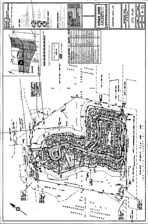
The intent of this application is to amend the zoning to permit the construction of 113 row house units and two semi-detached units on this site.
DISCUSSION
In 2003, Council approved a new Official Plan
for the amalgamated City of Ottawa, which was intended to replace all the
former Official Plans. This document
designated the site as part of an Enterprise Area between Highway 174 and the
Ottawa River. Enterprise Areas were
primarily intended for employment, but permitted residential uses as long they
were in the form of townhouses, stacked townhouses or apartments and the
majority of the land remained devoted to employment. This plan was appealed to the Ontario Municipal Board by a number
of appellants.
As a result of these appeals, two Official Plan
Amendments were adopted which specifically relate to his site. The first was initiated by the site’s Owners
and served to alter the land use designation under the former Cumberland Urban
Official Plan from Employment Area to Residential - High Density. The applicant provided documentation
illustrating that the employment targets can be satisfied on the remaining
lands designated Employment Area. The
City supported this amendment on the strength of the direction of the City
Council Approved Official Plan. The
amendment permitted residential uses, and at the same time required a minimum
density of 39 units per hectare. This
amendment was initiated by the owners to enable the rezoning of the site for
residential purposes, while assuring conformity with the old and new official
plan regimes.
In July 2005, Council adopted Amendment 28 to
the City Council Approved Official Plan.
This amendment made changes to various sections of the Plan and to
Schedule ‘B’, Urban Policy Plan and was intended to resolve many of the
outstanding appeals to the new City Council Approved Official Plan. The changes to Schedule ‘B’ included a
change to the designation of the subject land from Enterprise Area to General
Urban Area in recognition of the amendment to the Cumberland Official Plan and
the proposed residential uses.
Amendment 28 has also been appealed, however none of the appeals
specifically relate to this property.
As a result, the policies of the City Council Approved Official Plan are
in full force and supersede the policies of the former Cumberland Official Plan
for this site. General Urban Area is
the current designation which applies to these lands.
Under the General Urban Area policies of the
City Council Approved Official Plan there are no requirements for minimum
densities. However, the applicant has
proposed townhouses, which respects the former Enterprise Area polices. The only residential density requirement in
the City Council Approved Official Plan is found in Developing Community policy
that provides a target of 29 units per hectare, which this application exceeds.
The subject property is zoned D-CR Development
– Commercial/Residential in the former City of Cumberland Urban Zoning By-Law. A Development Zone is intended to signify
Council’s approval in principle to future development of the land for the
purposes indicated. Only existing uses
are permitted on this property until the Development Zone is amended.
Through this application, the applicant is
requesting the zone to be changed to R4A-X1 Residential-Multiples – Exception
One. This zone permits row dwellings,
senior citizen dwellings and accessory uses.
The site plan and other applications made with
this Zoning By-law amendment application give a clear vision of what the
applicant wishes to build on the site.
They are proposing to build 113 row house units and two
semi-detached units with a total of 259 parking spaces. This
proposal has a density of 30.7 units per hectare, which is slightly above the
targets set out in the Developing Community policies.
As required in the City Council Approved
Official Plan the applicant has proposed not to develop or alter the lands
within 15 metres from the edge of each ravine.
The applicant has agreed to deed these lands to the City along with the
ravines to be protected as natural area.
This amendment will rezone these parts to CON (Conservation Zone)
The applicant did
request some additional amendments to the R4A-X1 Zone to address details found
in their Site Plan. These amendments
include permitting Semi-Detached units, reducing the outdoor amenity area to 45
square metres and increasing the width of driveways to 5.2 metres. Other requests are sufficiently covered by
existing clauses.
A new exception zone will be created to address
these issues as detailed in Document 2.
Staff support these requests as they are in keeping with the desired
density and scale while providing additional conservation lands.
Rationale
This application conforms to the General Urban Area
polices which permits a wide range of housing types. In addition, it satisfies the intended density in the Developing
Community polices and continues to meet the criteria for residential uses in an
Enterprise Area. There is an existing
residential enclave and a proposal for more residential development to the west
of the site. The zoning requested by
the applicant would permit residential development similar to the neighbouring
developments.
As this was one of many applications for this
site, the applicant provided the City with number of studies supporting the
applications. A servicing brief was
submitted indicating that there are sufficient municipal services to the
site. A geotechnical and slope stability
study recommends that the soils can support the load with appropriate setbacks
from the top of the bank. The traffic
impact assessment concluded that the existing streets could accommodate the
potential traffic from this site.
Staff had hoped for more units and a higher density on this site to
take advantage of existing infrastructure.
The environmental policies concerning Protection of Surface Water have
had significant consequences on the amount of this site that was developable
and the configuration of that development.
Up to 40% of the land area is subject to a no touch setback from the top
of the ravine banks and is being dedicated to the City for conservation. The remaining lands are limited by their
shape, which does not lend itself to development in a more intensive
manner. As well, soil constraints limit
the form of development possible.
Higher density uses such as stacked townhouses would require expensive
piling.
Staff support the rezoning and will continue to work with the applicant
on remaining applications to provide a high quality development.
ENVIRONMENTAL IMPLICATIONS
Due to the environmental features and characteristics of the site, the applicant has provided the City with a Wetland Impact Statement, Tree Preservation Plan, Tree Planting Plan and an Archaeological Assessment, all of which are being reviewed as part of the site plan process. The material provided by the applicant to this point does not indicate that there is any impact on the natural areas around the site. A large portion of the site is being dedicated to the City.
CONSULTATION
Notice of
this application was carried out in accordance with the City’s Public
Notification and Consultation Policy. The Ward Councillor is aware of the application
and the staff recommendation.
Comments have been received expressing
opposition to the loss of employment land in Orléans. It has been explained that the amendments made to the former
Cumberland and the City Council Approved Official Plans has already changed the
designation of these lands from Employment to Residential. These amendments took into account the
demands for employment land in the future.
This application is consistent with the approved policies.
The applicant attended a meeting of the Riverwalk Community Association to show the proposal. She was asked about the loss of employment lands and explained that Council had approved the amendments to redesignate the lands Residential. Once that was explained, the site plan was presented and received positive comments.
FINANCIAL IMPLICATIONS
APPLICATION PROCESS
TIMELINE STATUS
This application was not processed by the "On
Time Decision Date" established for the processing of Zoning By-law
Amendment to allow for a new Ward Councillor to be elected and provide
comments, and to enable a complete reviw of complicated issues.
SUPPORTING
DOCUMENTATION
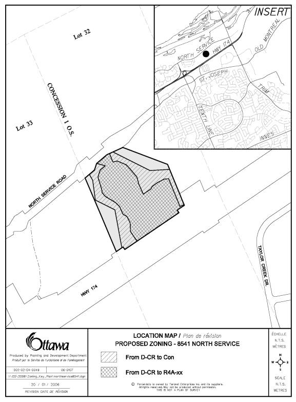
Document 1 Location
Map
Document
2 Details of Recommended Zoning
Document 3 Site Plan
DISPOSITION
Corporate
Services Department, City Clerk's Branch to notify the owner Sandpiper Cove
Ltd., 451 Daly Avenue, Ottawa, ON K1N 6H6, applicant D. G. Belfie Planning and
Development Consulting Ltd., 21 Pinecone Trail, Stittsville, ON K2S 1E1, Signs.ca, 866 Campbell
Avenue, Ottawa, ON, K2A 2C5 and Ghislain Lamarche, Program Manager, Assessment,
Financial Services Branch (Mail Code:
26-76) of City Council’s decision.
Planning
and Growth Management Department to prepare the implementing by-law, forward to
Legal Services Branch and undertake the statutory notification.
Corporate Services Department, Legal Services Branch to forward the implementing by-law to City Council.
Document 1
LOCATION MAP
Document 2
DETAILS OF RECOMMENDED ZONING
1. Section 6.18 the R4A zone of By-law
1-84 be amended to add a new exception zone, including the following
provisions:
(i) despite
subsection 6.18(a) the permitted uses are:
semi-detached
dwelling
row dwelling
(ii) the
lot line coincident with North Service Road is deemed to be the front lot line;
(iii) the
minimum required amenity area per dwelling unit is 45 square metres;
(iv) the
minimum required front yard is 10.0 metres;
(v) the
minimum required side yard where the side of a building abuts the property line is 1.5 metres;
(vi) the
minimum required rear yard is 6.0 metres;
(vii) the
maximum permitted lot coverage is 65%;
(viii) the
minimum required density is 30 units per hectare;
(ix) subject to the following changes, Section
4 “General Provisions” applies to private street and common elements
condominium developments with the modification that all yards and lot lines
referred to in Section 4 correspond to their equivalent yards and parcel
boundaries of the individual units in the private street and common elements
condominium development:
1. despite Section 4.10 “Frontage on a
Public Street”, row dwellings and semi-detached dwellings accessing a private
street within a common elements condominium development are not required to have
frontage on a public road, provided the private road has access to a public
road;
2. despite Section 4.23.1 “Schedule For
Parking Requirements” the minimum required parking spaces is 1.5 spaces per
unit, 12% of which must be reserved for visitors;
3. the chart in Section 4.23.2 7(b)
does not apply to this site and that maximum driveway widths with be in
accordance with an approved site plan;
4. despite Section 4.23.2 9(a) and (b)
visitor parking is permitted as an element within the common elements condominium
and is not required to be located on the same lot as the dwelling unit;
5. despite Section 4.25 “Permitted
Projections”,
(A) landings, porches, covered porches,
and verandas may
project a maximum of 1.5
metres into the building spacing between end units; and
(B) steps and ramped walkways are
permitted to project into the building spacing between end units;
(x) the dwelling units and
the land in a row and semi-detached dwelling development may be divided or
severed into separate, legally conveyable parts without each part meeting all
of the requirements of this by-law as long as the overall development complies
with the requirements of this by-law.
2.
Schedule F of By-law 1-84
be amended to rezone part of the subject property from D-CR to CON and part from
D-CR to R4A-Exception as shown on Document 1.
Document 3
SITE PLAN