Report
to/Rapport au :
Planning and Environment Committee
Comité de l'urbanisme et de
l'environnement
and Council / et au Conseil
06 December 2005 / le 06 décembre 2005
Submitted by/Soumis par : Ned Lathrop, Deputy City Manager/
Directeur municipal adjoint,
Planning and Growth Management/Urbanisme et Gestion de la croissance
Contact
Person/Personne ressource : Grant Lindsay, Manager/Gestionnaire
Development Approvals/Approbation des demandes
d’aménagement
(613) 580-2424 x, 13242
|
SUBJECT: |
ZONING - 43, 45 and 49 MCARTHUR AVENUE
|
|
|
|
|
OBJET : |
ZONAGE -
43, 45 ET 49, AVENUE MCARTHUR |
REPORT RECOMMENDATION
That the Planning and Environment
Committee recommend Council approve an amendment to the former City of Vanier
Zoning By-Law Number 2380, to change the zoning of 43, 45 and 49 McArthur
Avenue and 356 Mayfield Street from R6 - Residential Complex Zone to C1/A -
District Commercial Zone as as shown in Document 1 and with
Exceptions as detailed in Document 3.
RECOMMANDATION DU
RAPPORT
Que le Comité de l’urbanisme et de
l’environnement recommande au Conseil d’approuver une modification au Règlement
de zonage numéro 2380 de l’ancienne Ville de Vanier en vue de changer la
désignation de zonage du 43, 45 et 49, avenue McArthur et du 356, rue Mayfield
de R6 – zone de complexe résidentiel à C1/A – zone commerciale de district, tel
qu’il est indiqué dans le document 1 et expliqué dans le document 3 avec les
exceptions.
BACKGROUND
The site, as 43, 45 and 49 McArthur Avenue and 356
Mayfield Street is located at the northwest corner of McArthur Avenue and
Mayfield Street. The subject site has a total lot area of 1
180 square metres with 38.63 metres of frontage along McArthur Avenue and 30.45
metres of frontage along Mayfield Street.
A semi-detached building and two triplexes currently occupy the
site. The site is bounded to the east by an automotive garage, to the north by
a 4 ½ storey apartment building, to the west by the Royal Canadian Geographical
Society headquarters, and to the south by a food store and a mix of commercial
and residential uses along the south side of McArthur Avenue.
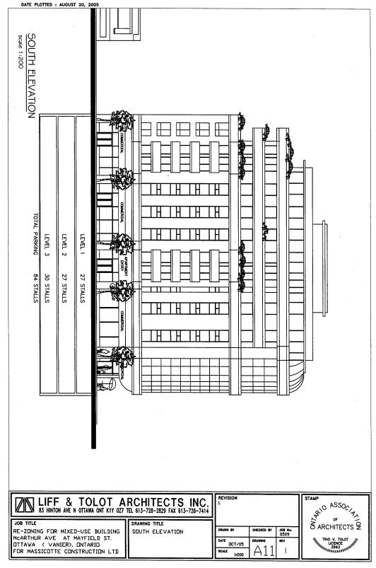
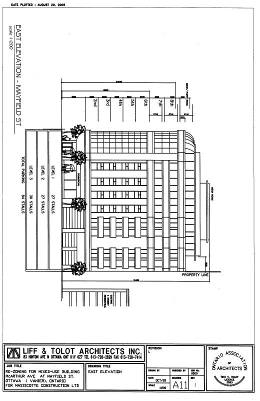
The applicant has proposed to develop the subject lands with a nine storey, mixed-use commercial and residential building with three levels of underground parking. Floors 7 and 8 are to be set back from the edge of the 6th floor. The top floor (9th floor) is to be used only for the required amenity space and mechanical room and is also to be smaller in size (set back from the edge of the 8th floor). The proposed development will have 528 square metres of commercial space on the ground floor and 52 residential condominium units (20 one-bedroom units and 32 two-bedroom) on the upper floors. The below-grade parking spaces and the at-grade loading space will be accessible from Mayfield Street and the main entrance to the building will be from McArthur Avenue. Visitor parking spaces will be located on the first below-grade parking level.
Current Zoning
The subject lands are currently zoned R6
(Residential Complex Zone – 120 units per net hectare) and permits limited
residential uses including an apartment dwelling house, and limited
non-residential uses such as day care centre, school, nursery school, and
senior citizen drop-in centre.
For the
residential use, the maximum building height can be up to 24.5 metres (8
storeys) and there is a density of 120 units per net hectare.
Proposed Zoning
The applicant has requested to change the existing
R6 - Residential Complex Zone to a C1/A - District Commercial Zone with
exceptions to building setback, density, and height. This zoning is intended to accommodate a nine storey mixed
residential and commercial building close to McArthur Avenue, with underground
parking. The requested exceptions to
the C1/A zone pertain to:
·
allowing a maximum
building height of 32.0 metres for part of the site and regulating heights with
a Schedule
·
allowing a maximum density
of 445 units per net hectare
·
allowing balconies to
project into any required yard but not closer than 0.2 metres to any lot line
·
prohibiting the following
uses: commercial parking lot and secondary commercial parking
The C1/A zone allows for such uses as one or more
dwelling units, home for the aged and a nursing home if located above the first
storey, and that the first storey be occupied by the permitted non-residential
uses. A wide variety of non-residential
uses such as retail stores, offices, clinics, cinema, service uses and public
uses are permitted. The maximum
building height permitted is eight storeys; floor space index for
non-residential uses is 2.0; minimum lot area is 450 square metres; minimum lot
frontage is 15.0 metres; minimum front yard setback is 3.0 metres; minimum rear
yard setback is 3.5 metres; minimum interior side yard is 0.0 metres; minimum
exterior side yard is 3.0 metres; and the minimum dwelling unit area is 37.0
square metres.
DISCUSSION
The property is designated
District Commercial and Residential Intensification Focus Zone in the Former
City of Vanier Official Plan, Traditional Mainstreet in the City Council
Approved Official Plan and General Urban Area in the Former Regional Official
Plan. All three of these plans permit
residential intensification with commercial uses at grade for the subject
property.
CITY COUNCIL APPROVED OFFICIAL PLAN
Section
2.2.3 Managing Growth Within the Urban Area notes that the projected urban population
and associated land required for housing and jobs can be accommodated within
the existing urban area. It also
provides for intensification within the designated urban area to be directed to
locations with significant mixed use development potential. This includes areas designated as Central
Area, Mixed-Use Centres, Employment Areas, Enterprise Areas, Developing
Communities and Mainstreets. The subject site is designated Traditional
Mainstreet in the Council approved Official Plan.
Lands designated Mainstreets are intended to become linear mixed-use focal areas allowing for a more dense and urban form of development, while building sensitively on existing neighbourhoods and supporting pedestrian activity. The proposed rezoning to allow ground floor commercial uses, to increase the maximum height so as to accommodate an additional floor over what is now allowed, and to increase the residential unit count will allow a more dense and urban form of mixed use development for the subject property with ground floor commercial and upper floor residential to achieve the Plan’s objectives for Mainstreets. Further, the recommended C1/A zone will match the existing zoning of the abutting properties along the north side of McArthur Avenue to the east and west of the subject lands to provide for continuity of the nature of uses permitted along McArthur Avenue.
In addition to assessing the proposal relative to the policies applicable to Mainstreets, the Compatibility and Community Design section of the City Council Approved Official Plan also sets out policies to be considered in the review of intensification and infill development applications. This section of the Plan acknowledges that zoning changes may be needed to allow height or density increases to achieve the plans intensification objectives. The location of the subject property matches the conditions possibly requiring a zoning amendment, and the height and density increases requested are in keeping with the approach anticipated by the Compatibility and Community Design section. Policies are set out that direct the use of compensatory physical design techniques to deal with variations from the existing architectural and built form relationships and characteristics found in the area. The proposed amendment will exhibit a built form that is different from that now found in the immediately adjacent areas which tend to be characterized by lower profile developments. However, the proposed development is consistent with the built form contemplated under the current zoning which allows for an eight storey building on the property. The additional storey, to respond to the policies dealing with development compatibility will be setback from the main building facades with the additional storey intended to accommodate only the buildings mechanical penthouse and common amenity space for the residential component of the development.
The
policies for water and wastewater servicing require that there be a reliable
water supply and safe wastewater disposal available to all development. There is adequate water and sewer services
available to accommodate redevelopment at the subject location as proposed.
Also, a traffic impact overview submitted with the rezoning application has
indicated that the proposed development would have a minor impact on the
existing operation of the area road network.
This overview has been reviewed and accepted by staff.
In summary, the use proposed, the building height, building mass, setbacks
between buildings and rear yard setbacks all contribute to making this a
compatible infill project. It is
consistent with the planned function for the area as reflected by the
development scale permitted by the existing zoning and the policy directives of
the City Council Approved Official Plan for development along
Mainstreets. Density increases are moderate, servicing
efficiencies and improvements will be realized, and the traffic impacts are
minor.
FORMER REGIONAL OFFICIAL PLAN POLICIES
The Official Plan of the former Region of Ottawa Carleton (ROP) designates the subject lands as General Urban Area. Lands designated General Urban Area are to be used primarily for residential purposes, and for supportive shopping, service and community facilities. The ROP contains a development strategy for residential intensification. As stated in the Official Plan, this strategy is intended to encourage denser, compact and more balanced development on land designated for urban purposes. This policy was established to achieve objectives related to reducing the dependence on the automobile, providing more efficient use of existing land, facilities and services as well as supporting and encouraging economic development.
The ROP policies of Section 2.5 deal with development inside the Greenbelt and support zoning changes that ensure a mix of residential and non-residential development on Regional roads with transit routes and support zoning by-laws for higher density throughout the urban area. The policies of Section 2.5 call for development that respects the characteristics of existing communities and minimizes significant impacts on adjacent established residential areas. The proposed re-zoning will:
· contribute to a mix of residential and street-oriented commercial development along McArthur Avenue, which is a Regional road served by transit routes;
· foster an opportunity for a development providing increased density in the urban area;
· provide for a built form consistent with that contemplated for the site and area under the current zoning ; and
· have minimal impact on the adjacent existing residential area.
The proposed re-zoning is therefore considered to be in keeping with the intent of the General Urban Area designation and satisfies the intent of the policies of the ROP pertaining to mixed-use development in the urban area.
FORMER CITY OF VANIER OFFICIAL PLAN
The former City of Vanier Official Plan designates the subject lands as District Commercial (Schedule “A”) and Residential Intensification Focus Zone: Southwest Sector (Schedule “E”).
The District Commercial policies state that uses located within this designation shall contain a variety of small professional offices, specialty businesses, personal service uses, retail stores and restaurants. Mixed-use projects comprising of commercial uses at-grade with residential on the upper floors is required as a minimum. Streetscape improvements and neighbourhood-style building facades will create a unique and attractive environment. The proposed 9-storey residential building will meet the policies of Section 4.4.1.2 of the former City of Vanier Official Plan. The proposed development has architectural interest, is oriented to the street, and will improve the streetscape along McArthur Avenue and Mayfield Street.
Residential Intensification Focus Zone: Southwest Sector (Schedule “E”): Within residential intensification zones, densification, infill and redevelopment forms of intensification will be permitted and encouraged. Such zones have been defined on the basis of locational characteristics such as proximity to collector or arterial roads, proximity to public transit and the existence of natural land assemblies. The proposed rezoning to permit one additional storey to accommodate residential amenity space for a mixed-use development and allow for an increased residential unit count will fulfill the policies of the residential Intensification Focus Zone.
CONSULTATION
Notice of this application was carried out in accordance with the City’s Public Notification and Consultation Policy. There were five responses to the notification, which are described and addressed in Document 7.
The Ward Councillor is aware of this application and the staff recommendation. The Councillor held a meeting on October 4, 2005 with all concerned residents and the developer. The issues raised are described and addressed in Document 7.
FINANCIAL IMPLICATIONS
N/A
APPLICATION PROCESS TIMELINE STATUS
This application was not
processed within the “On Time Decision Date” established for Zoning By-law
Amendments. More time was required to
address the issues related to the original request of developing the site with
a 14-storey, mixed-use building, and to agree on a more compatible development.
SUPPORTING DOCUMENTATION
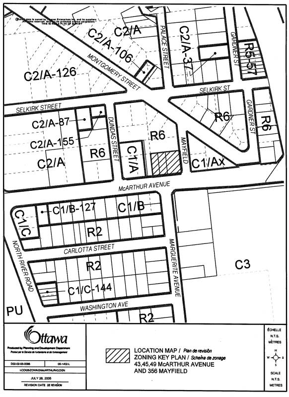
Document 1 Location
Plan
Document 2- Explanatory Note
Document 3 Details of Proposed Zoning
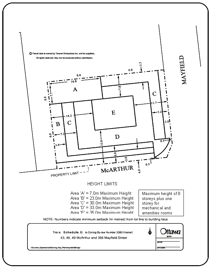
Document 4 Schedule G (building heights and setbacks)
Document 5 Proposed South Elevation
Document 6 Proposed East Elevation
Document 7 Consultation Details
DISPOSITION
Department of Corporate Services, Secretariat Services to notify the owner/agent (Jean Massicotte, 319 Palace Street, Ottawa, Ontario, K1L 7V5) and the Program Manager, Assessment, Corporate Services Department of City Council’s decision.
Legal Services to forward the implementing by-law to City Council.
Planning and Growth Management Department to prepare the implementing by-law, forward to Legal Services Branch and undertake the statutory notification.
Document 2
EXPLANATORY NOTE
THE FOLLOWING IS AN EXPLANATORY NOTE TO BY-LAW NUMBER
By-law Number ……… amends By-law Number 2380, of the former City of Vanier Restricted Area (Zoning) By-law. This amendment affects the lands located at the northwest corner of McArthur Avenue and Mayfield Street in the former City of Vanier. These assembled parcels of land are known municipally as 43, 45 & 49 McArthur Avenue and 356 Mayfield Street. It is proposed to rezone the property to permit the development of a 9-storey, mixed-use commercial and residential building with three levels of underground parking. The extent of the lands can be seen on Document 1.
Current Zoning
The subject property is currently zoned R6 (Residential Complex Zone – 120 units per net hectare) and permits limited residential uses including an apartment dwelling house, and limited non-residential uses such as day care centre, school, nursery school, and senior citizen drop-in centre. The maximum building height is 24.5 metres (approximately 8 storeys) and there is a density limit of 120 units per net hectare. All of the yard setbacks vary from a minimum of 4.5 metres for the front yard, 7.5 metres for the rear yard, and 4.5 metres for an exterior side yard. Provisions such as lot frontage, lot area, interior side yard, dwelling unit area, and landscape open space are also set out.
Proposed Zoning
The proposed zoning is C1/A – District Commercial Zone with exceptions. The C1 zone permits a common set of commercial and residential uses. Residential uses such as one or more dwelling units, home for the aged, and nursing home, if located above the first storey, and that the first storey be occupied by the permitted non-residential uses (commercial) are permitted. A wide variety of non-residential uses such as retail stores, offices, clinics, cinema, as well as service uses and public uses are permitted. The suffix “/A” is intended to refer to zoning provisions applicable to areas of high intensity development in the District Commercial Zones.
The exceptions proposed for the C1A zone to accommodate the proposed development are the following: regulating the maximum building heights, yard requirements and setbacks of building walls as per Schedule G (see attached); allowing a maximum density of 445 units per net hectare; allowing balconies to project into any required yard but not closer than 0.2 metres to any lot line; prohibiting a commercial parking lot and secondary commercial parking uses.
Document 3
DETAILS OF RECOMMENDED ZONING
1. The property as shown in Document 1 will be rezoned from R6 to C1/A-exception including the following zone requirement exceptions:
a. the maximum building heights are as per Schedule G
b. the yard requirements and setbacks of building walls are as per Schedule G
c. despite subsection 6.29 (a) the maximum density is 445 units per net hectare
d. subsection 6.29 (d) does not apply
e. balconies may project into any required yard but may not be located closer than
0.2 metres to any lot line.
f. commercial parking lot and secondary commercial parking uses are prohibited.
2. Document 4 will be added to By-law 2380 as Schedule G.