12. EAST URBAN COMMUNITY - COMMUNITY DESIGN PLAN
(PHASE 1 AREA) COLLECTIVITÉ URBAINE DE L’EST - PLAN DE CONCEPTION
COMMUNAUTAIRE (SECTEUR DE LA PHASE 1) |
Committee RECOMMENDATIONS AS AMENDED
That Council approve the
East Urban Community - Community Design Plan (Phase 1 Area) as detailed in
Document # 7 (distributed under separate cover), subject to the following
amendments:
1.
The CDP for the East Urban Community be amended as follows:
a)
Amend the second last bullet on page 3 to add:
“Identifies the Waste
Disposal Site and its influence area.”
b)
Amend Legend for Figure 6 be amended to include reference to the
Waste Disposal Site.
c)
Amend Section 3.1, third paragraph to add “organic material for
composting.”
d)
Amend Section 4.1 to add reference to: “Section 3.8 Solid Waste
Disposal Sites.”
e)
Amend Section 4.4 to include the following reference:
“The WSI lands are
regulated by a Certificate of Approval issued by the Ministry of the
Environment. This Certificate does not
have an expiry date and WSI is expected to continue operations well into the
future. It is in the best interests of
WSI, the City and the future residents of the community to recognize that this
facility is a key component of the waste management infrastructure of the
region and it plays an important role in the provision of waste management
services such as recycling, composting and disposal for the community. Development should not hamper the ability of
this site to perform its prescribed function to serve the community.”
f)
Amend Section 4.4, paragraph 4 to add reference to:
“D-1 and “ D-4 and
“industrial solid waste
and/or sewage sludges” and
“The studies will be
required to be completed by the proponent and the City will not approve
development within the influence area as shown on the figures contained in the
CDP until such time as the required studies are provided to the City’s
satisfaction.”
g)
Amend Section 4.6 by adding:
“The existing Waste
Disposal site has existed since the 1960’s.
Operations are anticipated to continue through the planning period which
may result in limitations on the use of certain lands close to the site.”
h)
Amend Section 6.1 by adding the following sentence 3:
“All development
applications must be accompanied by the technical studies identified in the
list of Required Studies and Assessments.
Additionally, all applications within the 500m influence area from WSI
must be accompanied by studies related to the Solid Waste Disposal Site
Influence Area.”
2.
That staff be directed, during the preparation of the MUC CDP, to
re-evaluate the alignment of the BHBPE in the vicinity of Mer Bleue.
3.
That the social housing component of the East Urban Community –
Community Design Plan (Phase 1) be at least 7% of residential units (i.e.
affordable to the 20% of households in Ottawa that are lower income), subject
to Federal/Provincial funding.
RECOMMANDATION MODIFIée
DU COMITé
Que le Conseil approuve le Plan de conception communautaire (Phase 1) de
la collectivité urbaine de l’Est, tel que décrit dans le Document no
7 (distribué sous pli distinct), modifié de la façon suivante :
1. Que le Plan de conception
communautaire de la collectivité urbaine de l’Est soit modifié par :
a) L’ajout
à l’avant-dernière puce de la page 3 de la mention :
« Indique le lieu d’enfouissement et sa zone d’influence ».
b) La modification de la
figure 6 par l’inclusion d’une référence au lieu d’enfouissement;
c)
La modification du troisième
paragraphe de l’alinéa 3.1 par l’ajout des mots « matières organiques
destinées au compostage ».
d)
L’ajout à l’alinéa 4.1 d’une
référence à : « Alinéa 3.8 Lieux d’enfouissement de déchets
solides ».
e)
L’ajout à l’alinéa 4.4 de la
mention :
« Les terrains de Waste Services Inc. (WSI) sont réglementés en vertu d’un
certificat d’autorisation délivré par le ministère de l’Environnement. Ce
certificat ne comporte aucune date d’échéance et on s’attend à ce que WSI
poursuive ses activités pendant de nombreuses années encore. Il est dans
l’intérêt de WSI, de la Ville et des futurs résidents de notre collectivité de
reconnaître que cette décharge est un élément clé de l’infrastructure de
gestion des déchets de la région et qu’elle joue un rôle important en assurant
à la collectivité des services de recyclage, de compostage et d’élimination des
déchets. Les projets d’aménagement ne devraient pas nuire à sa capacité de
réaliser son mandat de servir la collectivité. »
f)
L’ajout au paragraphe 4 de l’alinéa
4.4 des mentions :
« D-1 et D-4 », « déchets solides industriels et boues
d’épuration » et
« Le promoteur devra compléter les études et la Ville ne donnera
son aval à l’aménagement prévu – qui est indiqué sur les figures du Plan de
conception communautaire – dans la zone d’influence que lorsqu’elle aura reçu
les résultats de ces études, lesquelles études auront été réalisées à sa
satisfaction. »
g)
L’ajout à l’alinéa 4.6 de la
mention :
« Le lieu d’enfouissement
actuel est en fonction depuis les années 1960 ». Il devrait continuer ses
activités durant la période de planification, ce qui pourrait imposer certaines
restrictions sur l’utilisation de terrains avoisinants. »
h)
L’ajout à l’alinéa 6.1 de la phrase
no 3 suivante :
Toute demande d’aménagement doit être accompagnée par les études
techniques indiquées dans la liste des études et évaluations requises. En
outre, les demandes pour des terrains qui se trouvent dans la zone d’influence
de 500 m de WSI doivent être accompagnées d’études relatives à la zone
d’influence du lieu d’élimination de déchets solides. »
2. Que la directive soit donnée au
personnel, lors de la préparation du Plan de conception communautaire du centre
polyvalent, de réévaluer l’alignement de la rocade de Blackburn Hamlet dans le
voisinage de Mer Bleue.
3. Que la composante « logement
social » du Plan de conception communautaire (Phase 1) de la collectivité
urbaine de l’Est consiste d’une proportion d’au moins 7 % de logements
résidentiels (c’est-à-dire qui sont abordables pour les 20 % de ménages
d’Ottawa à faible revenu), sous réserve de l’obtention d’un financement du
gouvernement fédéral ou provincial.
Documentation
1. Deputy
City Manager, Planning and Growth Management report dated 7 June 2005
(ACS2005-PGM-POL-0026).
2. Extract
of Draft Minutes, 28 June 2005 will be distributed prior to Council.
Report to/Rapport au :
Planning and Environment Committee
Comité de l'urbanisme et de
l'environnement
and Council / et au conseil
Submitted by/Soumis par : Ned Lathrop, Deputy City Manager/Directeur municipal adjoint,
Planning and Growth Management / Urbanisme et Gestion de la croissance
Contact Person/Personne
ressource : Richard Kilstrom, Manager
Community Design and Environment / Conception et
milieu communautaire
(613) 580-2424 x22653, Richard.Kilstrom@ottawa.ca
|
SUBJECT: |
|
|
|
|
|
OBJET : |
COLLECTIVITÉ
URBAINE DE L’EST – PLAN DE CONCEPTION COMMUNAUTAIRE (SECTEUR DE LA PHASE 1) |
REPORT RECOMMENDATION
That
the Planning and Environment Committee recommend that Council approve the East
Urban Community - Community Design Plan (Phase 1 Area) as detailed in Document
# 7 (distributed under separate cover)
RECOMMANDATION DU RAPPORT
Que le Comité de l'urbanisme et de
l'environnement recommande que le Conseil approuve le Plan de
conception communautaire (Phase 1) de la collectivité urbaine de l’Est, tel que
décrit dans le Document no 7 (distribué sous pli distinct)
EXECUTIVE SUMMARY
The purpose of preparing a Community Design Plan (CDP) for the East Urban Community (EUC) is to establish a land use framework that reflects the principles, objectives, and policies of the Official Plan that will guide the preparation and review of development applications. The East Urban Community CDP area is located in the southeast portion of Orléans and is approximately 570 hectares in size. The CDP area has been divided into three geographic sections representing the three Phases of planning study for the area. This report and CDP covers the area identified as Phase 1.
The East Urban Community CDP (Phase 1 Area) was initiated in November 2003. Although the Phase 1 CDP establishes the broader planning framework for all three geographic areas, it focuses detailed study and analysis on the 206 hectare Phase 1 area.
The CDP was guided by a technical advisory committee and involved broad input from the public, landowners, internal City departments, school boards, and outside technical agencies. The study process included detailed geotechnical and servicing analysis.
The CDP establishes the arrangement of the public road network, the location of residential, commercial and institutional uses, as well as the location parks and open spaces for the Phase 1 Area. The CDP also serves as a community development guideline document. The Phase 1 Area has an estimated future population of 9,000 people in approximately 3,500 units.
The purpose of this report is to present the recommended Community Design Plan (Phase 1 Area) to Committee for recommendation to Council for approval. Both the Phase 2 area and the Mixed Use Centre will undergo their own CDP processes.
Financial
Implications:
The development of major servicing infrastructure, parks and recreational trails within the Phase 1 area will be funded as per the new City of Ottawa Development Charges By-law.
Public
Consultation/Input:
Three advertised public open house meetings were held in the community at key junctures in the study. The first open house was held on November 27, 2003. The purpose of this meeting was to introduce the study, to provide background and contextual information, and to identify study objectives and timelines.
The second open house was held on May 17, 2004. The purpose of the meeting was to present the preliminary Land Use Structure and Demonstration Plan. The meeting also outlined the proposed mix, density and location of land uses; illustrated the proposed general road network; and highlighted transit, pedestrian and cycling systems.
The third open house was held on January 20, 2005. This meeting presented the revised Land Use Structure and Demonstration Plans and highlighted the draft design guidelines for the community.
In addition to the meetings noted above, various meetings were held over the course of the study process with the school boards, conservation authorities, landowners and other stakeholders as required and requested.
RÉSUMÉ
Hypothèses
et analyse :
L’élaboration d’un Plan de conception communautaire (PCC) de la
collectivité urbaine de l’Est (CUE) visait à établir un cadre d’utilisation des
terrains reflétant les principes, les objectifs et les politiques du Plan
officiel et servant à guider la préparation et l’examen des demandes
d’aménagement. Le secteur visé par le PCC de la CUE est situé dans la partie
sud-est d’Orléans et couvre une superficie d’environ 570 hectares. Ce secteur a
été divisé en trois zones géographiques correspondant aux trois phases de
l’étude d’aménagement du secteur. Le territoire visé par le rapport et le PCC
correspond au secteur de la Phase 1.
L’élaboration du PCC de la collectivité urbaine
de l’Est (secteur de la Phase 1) a été entreprise en novembre 2003. Bien qu’il
établisse le cadre de planification général pour les trois zones géographiques,
le PCC de la Phase 1 livre une analyse détaillée du territoire de 206 hectares
correspondant au secteur de la Phase 1.
L’élaboration du PCC s’est appuyée sur les avis
d’un comité consultatif technique et une vaste consultation du public, des
propriétaires fonciers, des services de la Ville, des conseils scolaires et
d’organismes techniques externes. La préparation de l’étude a comporté une
analyse détaillée des conditions géotechniques et de la viabilisation.
Le PCC établit la disposition du réseau routier
public et l’emplacement des utilisations résidentielles, commerciales et
institutionnelles ainsi que des parcs et espaces verts pour le secteur de la
Phase 1. Le Plan sert aussi de guide d’aménagement communautaire. Selon
les estimations, le territoire couvert par la Phase 1 accueillera environ
3 500 unités, pour une population de 9 000 personnes.
Le rapport a pour but de présenter le Plan de
conception communautaire (secteur de la Phase 1) au Comité aux fins de
recommandation au Conseil pour approbation. Le secteur de la Phase 2 et le
centre d’utilisation polyvalente feront l’objet de plans de conception
communautaires distincts.
Répercussions financières :
L'aménagement des principales infrastructures de
services, des parcs et des sentiers récréatifs dans le secteur de la Phase
1 sera financée conformément au nouveau Règlement municipal sur les redevances
d'aménagement de la Ville d'Ottawa.
Consultation publique / commentaires :
Trois séances de consultation publique annoncées ont
été tenues au sein de la collectivité aux étapes cruciales de l'étude. La
première séance portes ouvertes a eu lieu le 27 novembre 2003 et visait à
présenter l'étude, à en établir le contexte, à livrer de l'information
contextuelle ainsi qu'à fixer les objectifs et l'échéancier de l'étude.
La deuxième séance de consultation
publique, tenue le 17 mai 2004, visait à présenter la Structure d'utilisation
des terrains et le Plan de démonstration provisoires. Ont aussi été présentés
l'assortiment, la densité et l'emplacement des utilisations des terrains, le
projet de réseau routier général ainsi que les réseaux de transports en commun,
piétonniers et cyclables.
La troisième consultation publique a été
tenue le 20 janvier 2005. On y a présenté les versions révisées de la Structure
d'utilisation des terrains et du Plan de démonstration ainsi que les lignes
directrices d'aménagement provisoires pour la collectivité.
En plus des consultations décrites plus
haut, diverses réunions ont été tenues au cours de l'élaboration de l'étude
avec les conseils scolaires, les offices de protection de la nature, les
propriétaires fonciers et d'autres parties intéressées, selon les besoins et
les demandes.
BACKGROUND AND STUDY PURPOSE
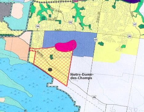
The East Urban Community – Community Design Plan (CDP) area is located in the southeast portion of Orléans. Mer Bleue Road bounds the CDP area to the east, a former Canadian Pacific Railway line bordering Mer Bleue Bog forms the south border, the National Capital Commission Greenbelt forms the west border, and a hydro corridor bounds the north edge. This total area is approximately 570 hectares in size.
Based on an approved General Concept Plan of May 1993, the former City of Gloucester prepared a drawing entitled the East Urban Community Orléans Expansion. The drawing outlined a road network, defined land uses and identified areas of low and medium density housing. It was updated in November 2000 and approved in principal by Gloucester City Council in December 2000.
Since December 2000 there have a number of changes to the land use designations in the study area. Additionally, the area is now subject to the policy direction set out in the City of Ottawa’s Official Plan (OP) as approved by the Province in November 2003 (appeals pending). Land use changes since 2000 and key OP policies include:
• Designation of the majority of the subject area as a Developing Community and the requirement for the completion of a CDP prior to development;
• The addition of a Mixed Use designation and the requirement for a statutory CDP for the Mixed Use Centre (MUC) prior to development;
• The change of land use designation from Business Park / Industrial to General Urban in the north-east section of the study area;
• An alignment of the future Blackburn Hamlet By-pass Extension which is different than the alignment shown on the East Urban Community Orléans Expansion, but that follows the recommendations of the Environmental Assessment;
• The Official Plan policies for a modified grid system of roads, higher density near transit stops, open space within 400m of all residential development, as well as specific density targets and unit mixes for Developing Communities; and
• New policy direction for the protection of fisheries habitat and natural features.
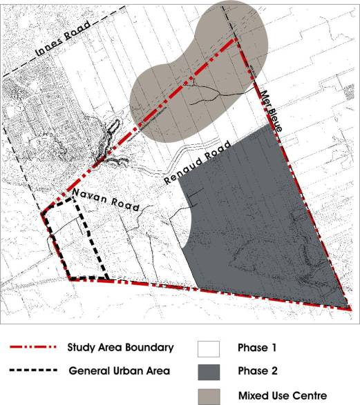
Document 1 shows the Official Plan designations for the study area. Document 2 shows the 570 hectare study area broken into three geographic sections representing the three Phases of planning study for the area. This report and CDP covers the area identified as Phase 1, as indicated in the Council approved Terms of Reference. The Terms of Reference highlighted that the Phase 1 would be completed first due to:
• Significant development pressure in the Phase 1 area, including numerous development applications which have been placed on hold until completion of the CDP;
• The highly fragmented ownership in Phase 2 and the lack of development pressure in the area when the CDP process was initiated (Fall 2003) as well as the need to prepare a subwatershed plan in the Phase 2 Area; and
• The lack of development pressure in the MUC area and the need for results from the East-West LRT study before beginning a CDP process for the area.
It is expected that the CDP for the Phase 2 area will begin following Council approval of this CDP. The Phase 2 CDP is on the Department's workplan for substantial completion in 2005.
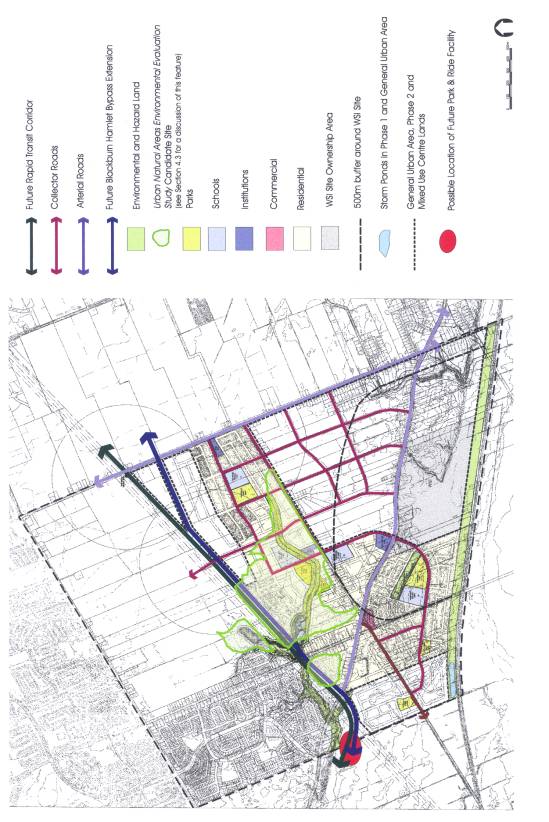
In November 2003, the CDP for the Phase 1 Area was initiated. Although the Phase 1 CDP establishes the broader planning framework for all three geographic areas, it focuses detailed study and analysis on the 206 hectare Phase 1 area. More specifically, the Phase 1 CDP:
• Indicates how the unit mix, residential density, parks and green space objectives found in the new Official Plan can be met;
• Illustrates the arrangement of all types of land uses, parks, green spaces and transportation corridors;
• Projects neighbourhood density, unit and population counts; and Serves as a community development guideline document, which incorporates and provided detail to the policy direction for design in the new Official Plan.
Additionally, the CDP for the Phase 1 Area:
• Considers the context of the adjacent General Urban Area;
• Considers the context of adjacent Phase 2 and MUC lands and has regard to the fact that the lands will also be examined under their own CDP processes;
• Rationalizes the size and geographic limits of the MUC;
• Identifies key land use, density and infrastructure assumptions for the Phase 2 and MUC lands; and
• Establishes the collector road network for
the entire 570 hectare area.
Summary of Planning
Context
The following provides a brief summary of existing conditions in the
CDP area:
• The study area is surrounded on the south
and west by NCC Greenbelt land. The
community of Chapel Hill South is
located adjacent to the north-east corner of the study area. The land north of the hydro corridor, which
is primarily undeveloped, is designated Employment Area and Mixed Use Centre in
the Official Plan. The majority of the
land to the east falls outside the urban area boundary. This includes the community of
Notre-Dame-des-Champs.
• The study area is primarily
undeveloped. Existing buildings are
mostly detached dwellings and garages situated along Navan, Renaud, and Pagé
Roads.
• The study area is part of the City’s urban
service area. There are no currently
identified restrictions to servicing the EUC from a watermain capacity point of
view.
• A detailed analysis of the sanitary sewer
capacity was completed in 2004 to ensure that sufficient residual capacity
existed in the outlet sewers to accommodate potential Official Plan densities.
• Ultimately, three storm water management
ponds will service the study area. The
ponds were originally identified in the EUC Master Drainage Plan (1992) and
have been carried forward in the various iterations of the Gloucester Council
approved EUC Concept Plans, as well as the EUC Master Infrastructure Plan
(1995) and the Gloucester EUC Infrastructure Studypdate (Stantec 2004). Subsequent to the MDP and Concept Plans,
Ponds 1 and 3 underwent Class Environmental Assessments and both ponds were
subsequently designed and approved by the Ministry of Environment in 2000.
• Waste Services Incorportated (WSI) occupies
a site of approximately 57.5 hectares on the south side of Navan Road. This landfill operation is within the Phase
2 area. Land within a 500m influence
zone is subject to the Official Plan requirement for study of the influence of
the waste disposal facility on future development. The 500m influence zone affects a significant portion of the
total CDP area, including a portion of Phase 1.
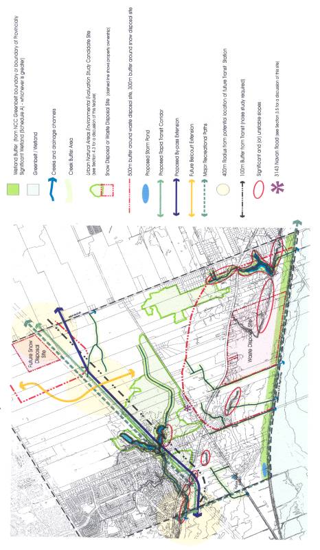
• The City’s Urban Natural Areas
Environmental Evaluation Study (UNAEES) includes a candidate site within the
Phase 1 area. The site has yet to be
evaluated and its environmental value as an urban feature is therefore unknown
at this time. The former Region’s
Natural Environment System Strategy (NESS, 1997) identified the site and
assigned an overall area assessment of Moderate for the area. The site requires evaluation before
implementing planning decisions can be made.
• There are three separate watersheds in the
study area; these are Mud Creek, McKinnons Creek and the Mer Bleue
tributaries. The Conservation
Authorities have noted that fisheries potential and the associated protection
and / or mitigation requirements for creeks and drainage channels in the study
area must be determined as part of the development review process. In the absence of updated field assessment,
a 30m buffer from normal high water mark or 15 metres from top of bank,
whichever is greater, will be required for all watercourses as per Official
Plan policy 4.7.3.1.
• Ninety-seven (97) species of wildlife –
amphibians, reptiles, mammals and birds – have been previously identified
within the study area. The protection
of contiguous wooded areas would be necessary for their continued presence in
the study area.
• The former City of Gloucester identified a
two-storey brick structure in the Phase 1 area as having some heritage significance. Any development around the structure should address that
potential heritage significance.
Description of the Community Design Plan
The CDP for the Phase 1 area has been guided by the direction and
policies in the Official Plan, in particular by Section 2.5.7, Collaborative
Community Building and Community Design Plans; and Section 3.6.4, Developing
Community. In addition, the proposed
plan has been guided by the various area-specific influences within and around
the study area. These include the
existing and proposed road and transit networks, the future Mixed-Use Centre
(MUC), the natural environment features, the existence of the waste disposal
facility and the servicing studies for the area.
The Phase 1 Area is primarily a series of residential
neighbourhoods. The neighbourhoods are structured by a modified grid road
network, existing natural features, and proposed new parks. Where possible, these new parks are located
adjacent to natural features. They are also, in most cases, located adjadent to
school sites. The homes in each
neighbourhood are within a 400m radius of the community parks and open
spaces. The homes in the Phase 1 Area
will also have recreational connections to the Mixed-Use Centre (MUC) and Phase
2 areas, as well as to communities beyond the CDP boundaries.
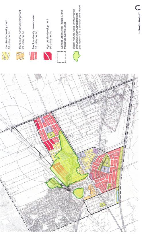
The CDP text is supported by three key figures: Influences on the
Study Area, Land Use Structure Plan and the Demonstration Plan (Documents 3, 4
and 5). The main components of the CDP
can be summarised as follows:
Residential
• The CDP meets the following OP targets for
residential development: a density of 29 units/net hectare for singles, semis,
and towns in developing communities; the requirement for 10% apartments; and
the requirement for a minimum mix of 30% multiples, and a maximum of 60%
singles and semi-detached dwellings.
• Residential areas include a mix of low (25
units/net ha), medium-low (29 units/net ha), medium (35 units/net ha) and
high-density (60 units/net ha) housing as shown on Document 5.
• The locations for each density designation
were determined in large part by the geotechnical analysis in Geotechnical
Considerations: East Urban Community (Golder 2004), which suggests that
certain areas have limited ability to support anything other than low density
development.
• Densities of 25 units/net ha can be
achieved by building a combination of singles, semis, and town homes. The geotechnical studies suggest that higher
density units such as stacked townhouses are not likely feasible.
• Densities of 29 and 35 units/net hectare
can be achieved by building a combination of singles, semis and townhouse units
(including ground-oriented stacked townhouses).
• The majority of the required apartments
will be located in the high-density areas (minimum 60 units/net hectare). The high-density areas are located within
600m of the two proposed transit stops, close to school and park sites, close
to the future amenities of the MUC and where feasible based on soils
conditions.
• The CDP estimates unit counts for the
entire study area (Phase 1, 2 and the MUC) in order to ensure that Official
Plan density and servicing requirements can be met.
Estimate of Total Units and Population in the CDP area (all phases)
|
Area |
Units |
Population |
|
Phase 1 |
3,498 |
9,003 |
|
Phase 2 |
1,726 |
5,322 |
|
Mixed Use Centre |
700 - 850 |
1,330 – 1,615 |
|
General Urban Area |
525 |
1,680 |
|
Estimate of existing Dwellings |
250 |
775 |
|
Total |
6,699 – 6,849 |
18,110 – 18,395 |
Affordable Housing
• Affordable housing will be required in accordance with applicable City policy in all new residential development and redevelopment in the EUC. The Official Plan directs that 25% of all new housing development and redevelopment is to be affordable to households at the 30th income percentile for rental and at the 40th income percentile for ownership. Within the Community Design Plan (CDP) area, approximately 1675 homes (6,699 units x 25%) should be within the affordability range as determined at the time of subdivision development approval.
• The development of “social housing” by social housing providers, with or without City funding or incentives, will be included within the total 25% of affordable housing in the community. For the EUC a target of approximately 5% of all homes, or about 335 homes total in the community, should be provided for social housing. These homes should be affordable to households at or below the 20th income percentile for Ottawa.
• The required housing type and appropriate
location for social housing in the community will be decided as part of the
technical circulation process at the time of development approval, subject to
Council allocation of funds. The preferred location for social housing will
have convenient access to public transit, shopping and community services.
Commercial
• Although the majority of the commercial
development, and associated jobs, will be located in the MUC and Phase 2 lands,
there is one local/community commercial site identified in Phase 1. This is meant to serve the immediate
residential area by providing convenience shopping and services.
• Implementing zoning by-laws will also
permit neighbourhood convenience commercial uses (corner stores) at the
intersections of collector roads.
Parks and Open Space
• Planning Act parkland dedication for Phases
1 and 2 results in approximately 25 hectares of parkland. The Phase 1
area includes six parks ranging in size from 0.8 to 3.1 hectares.
• Official Plan Schedule B designates a
contiguous Major Open Space with the CDP study area. The designation is shown covering both Phase 1 and Phase 2
land. Through the Phase 1 CDP and as
result of a major reconfiguration of the road network, the Major Open Space
will be relocated to the Phase 2 area.
The specific location of this park, within Phase 2 lands, will be
determined through the Phase 2 CDP. In
order to accurately reflect the location of the park on Schedule B, an Official
Plan Amendment will be undertaken at the completion of the Phase 2 CDP. The Phase 2 Major Open Space will be
approximately 13 hectares in size.
Criteria for determining the best location for this designation include:
excellent future transit connections, high visibility from the street,
vehicular accessibility and adjacency to collectors, pedestrian accessibility,
centrality and walking distance to surrounding neighbourhoods, topography, and
the buffer zone around the Waste Service Inc. site.
• The candidate UNAEES site, shown on
Documents 3 - 6, requires a full environmental evaluation as part of any
development review process and prior to planning decisions being made for the
affected lands. If the candidate site,
in part or in whole, is deemed to be significant, City staff will explore
options for protection. If the natural
feature cannot be protected in part or in whole by the City through the various
securement options, development of the land will proceed in accordance with the
underlying direction set out in the CDP.
• Documents 4 and 5 illustrate a 30m setback
along Mud Creek on either side of the normal high water mark. Although not shown on Documents 4 and 5,
within the Phase 1 area there are other creeks and watercourses that may be
necessary to retain and provide buffers for.
Development applications will be required to reflect the direction set
out by the Conservation Authorities in this regard. Buffers required by the Conservation Authorities must also be
coordinated with the setbacks required for slope protection.
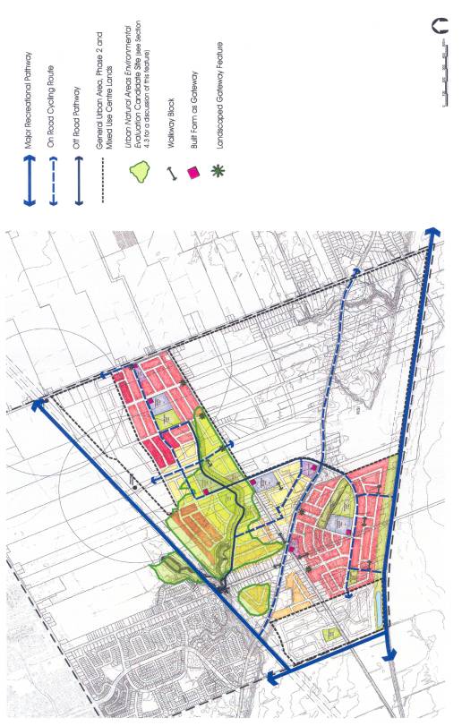
• Document 6 illustrates the proposed on and
off-road recreational path system through the Phase 1 area. This will link to the Major Recreational
Pathways identified in the Official Plan, to existing path systems to the north
as well as into both the Phase 2 area and the MUC.
• The projected population for the EUC would generate the need for a community level indoor recreation facility. It is anticipated that the facility would be located in one of the proposed parks - such as the future District Park - and that the facility might include a community centre (approximately 21,000sq ft), in combination with other facilities such as local exhibit and visual arts space, childcare space, district outdoor water play and a district outdoor skateboardpark.
Schools and Institutions
• Three Ottawa School Boards have requested a
total of four elementary school sites in the Phase 1 area.
• All of the schools sites will be dual-zoned
for school and residential purposes. In
the case where a school board releases their option on a site, a medium density
designation will apply.
• There are three sites in Phase 1 designated
for other institutions uses such as places of worship. These sites range in size from 0.6 to 1.3
hectares.
• It is expected that Phase 2 will contain
two additional elementary school sites and one high school site.
• Each
of the four Ottawa area school boards has confirmed that day care facilities
are either provided as part of initial elementary school construction or are
planned as part of a future phase of the school construction. Subject to Council approval of funding and
in accordance with the City’s childcare capital funding policy, the City
provides up to 80% capital funding for day care centres constructed by the
school boards. Daycares would also be
permitted on any institutional site, commercial site or as part of a community
building in any park. Daycares would also be permitted in private homes
throughout the community.
• Police Services have indicated that no facilities are required in the Phase 1 area and that there is no anticipated need for facilities in the Phase 2 area.
• A site of approximately 1.0 hectare will be
protected for a future Fire Hall in the Phase 2 or Mixed-Use Centre areas.
• Ottawa Paramedic Services have requested
that a site of approximately 930 square meters be protected for future
facilities. Possible sites will be identified
in the Phase 2 or Mixed-Use Centre areas.
Heritage Sites
• Sites identified by the former City of
Gloucester as having potential value will be evaluated on a
property-by-porperty basis by the proponent of development at the subdivision
or site planstage.
Transportation
• The transportation network is based on the
Official Plan direction of creating a modified grid system in order to ensure
porosity and connectivity through the community. This network is illustrated on Document 5.
• The network also aims to reduce the amount
of cut-through traffic to the Greenbelt from Renaud Road and to limit the
number of crossings of Mud Creek.
• The network illustrated on Document 5
represents the end state. Certain road
connections will ultimately be closed but only after sufficient alternative
routes are in place.
• Two proposed transit stations,
approximately 800m apart, are shown along the future LRT extension. The East-west LRT process is underway and
the Environmental Assessment report is scheduled to be completed by Fall 2006
and MOE approval should be in Spring 2007.
• Local transit will run on arterial and
collector roads and service schools, parks, and other community destinations.
Waste Disposal Facility
• The CDP assumes that all or a portion of
the waste disposal facility will continue in use for the foreseeable future.
• Studies of WSI’s level and area of
influence will be required for all development applications within the 500m
buffer zone, in accordance with the provisions of Sections 4.8.4 and 4.8.5 of
the Official Plan. All proposed
development within the 500m buffer area is subject to the results of the
required studies.
• The CDP states that all homes built within
500m of the WSI property line must have a condition in the subdivision agreement
which notifies purchasers of the location, physical size, continued existence
and nature of the WSI operation.
Additionally, all sales centres and promotional housing/development
materials must also clearly show the property limits of the WSI site and
indicate the nature of its operations.
• Note that development interests in Phase 1
have submitted a study of WSI’s level and area of influence; this study is
currently under peer review.
The Future Mixed-Use Centre
• The portion of the Official Plan’s
kidney-shaped MUC that lies south of the hydro corridor and west of Mer Bleue
Road was refined through the Phase 1 CDP process. The proposed new edge of the designation now follows the edge of
the Phase 1 road network and creates a logical land area for development. This refined portion of the MUC is smaller
than that shown in the Official Plan but it was determined that this smaller
area could still meet Official Plan targets for MUCs.
Design Guidelines:
The CDP examines how open space, the natural environment, public
infrastructure and built form can work together to structure neighbourhoods and
contribute to community development.
These guidelines are summarized below.
Landscape Guidelines
• The purpose of this section is to ensure
consideration for the following four key landscape principles: maintain and
enhance the existing natural infrastructure/landscape patterns; foster
biodiversity and establish planting guidelines that promote ecological
integrity; ensure that parks contribute to the green space network and
neighbourhood fabric; and establish feature areas that contribute to the green
space network created by parks and natural areas.
• The principles are supported by the
policies in the Official Plan, in particular those in Section 4.7.2. They are also supported by sections in the
CDP detailing requirements for Environmental Impact Statements, setbacks around
creeks and drainage channels, and criteria for evaluation of woodlots.
• The guidelines give criteria for the design
and distribution of parks and open spaces as well as the relationship of
single-loaded roads to these features.
The guidelines also establish minimum planting requirements in order to
enhance community greening and to mitigate tree cover lost as a result of
development.
Architectural Guidelines
• The architectural guidelines focus on
residential - the predominant building type in Phase 1 – but are also
applicable to institutional, civic, and commercial buildings.
• The architectural guidelines provide
guidance under the following topic headings: Building Orientation and Setbacks,
Facades, Corner Lots/Flankage Conditions, Parking and Garages, Mix of Building
Types and Architectural Character, and Service Equipment.
• The purpose of the guidelines is to ensure
that consideration is given to the relationship of buildings to the street, to
similarly consider the relationship of buildings to open space, to improve the
quality of the streetscape and promote visual diversity, to create a positive
environment for pedestrians and cyclists, and to preserve significant
vegetation.
Community Structure
• These guidelines focus on elements that
structure a community and contribute to its identity and liveability such as
Gateways, Views and Focal Points, the Pedestrian Environment, Cycling Network,
and Noise Attenuation.
• In accordance with the direction of the
Official Plan, the CDP is designed to avoid the use of noise barriers in favour
of mitigation through alternative measures such as unit and street orientation;
however, there are specific locations, such as adjacent to the Blackburn Hamlet
By-pass Extension and the LRT corridor, where noise barriers will likely be
required.
Implementation
• The implementation section identifies the
method of making changes to the CDP prior to, or as part of, development
approval and describes how changes will be tracked over time.
• Zoning by-law amendments will be undertaken
at the time of development approval and will implement the land use and
community design directions set out in the CDP.
• Required Official Plan amendments will be
made when the Phase 2 and MUC CDPs are brought to Planning and Environment
Committee.
• The design guidelines will be applied
through the implementing zoning and the site plan review process.
• Environmental Impact Studies will be
required with re-zoning and Plan of Subdivision applications.
CONSULTATION
Public
Open House Meeting #1 – November 27, 2003
Notice of this meeting
was published in L’Express and The Weekly Journal. Notice of the meeting was also mailed directly to all landowners
within the entire EUC study area (Phases 1, 2 and the MUC). The purpose of the meeting was to introduce
people to the study, to provide background and contextual information, and to
identify study objectives and timelines.
The purpose was additionally to receive public feedback on this
information. Approximately
75 people attended this meeting.
Questionnaires were completed and returned by 12 individuals. The majority of the enquiries had to do with
timing of the provision of services and future changes to the road pattern in
the area. Public comments and questions
are summarized in Document 8.
Public Open House Meeting #2 – May 17, 2004
Notice of this meeting was published in L’Express and The Weekly
Journal. Notice of the meeting was also
mailed directly to all major landowners, anyone who requested to be placed on a
mailing list and all individuals who signed in to the first Open House. The purpose
of the meeting was to present the preliminary Land Use
Structure and Demonstration Plans for the study area, to identify the planning
rationale behind the preliminary plans and to identify changes from the former
Gloucester concept plan. The meeting also outlined the proposed mix, density
and location of land uses, and illustrated the proposed general road network as
well as transit, pedestrian and cycling systems. Approximately 55
people attended this meeting. Similar
to the first Open House, participants were generally interested in timing of
future development. There were also
questions regarding development surrounding the study area, such as plans for
the proposed snow disposal facility on Mer Bleue south of Innes Road. Comments made at the meeting and written
comments provided at or after the meeting are summarized in Document 8.
Public Open House Meeting #3 – January
20, 2005
This meeting was held following completion of the
first draft of the Community Design Plan for the Phase 1 area. Notice of this meeting was published in the
local French and English community newspapers - L’Express and The Weekly Journal. Notice of the meeting was also mailed
directly to all major landowners, anyone who requested to be placed on a
mailing list and all individuals who signed in to the first and/or second Open
House. The purpose of the meeting was
to present the revised Land Use Structure and Demonstration Plans for the Phase
1 area to the community, and to highlight the
draft design guidelines for the community.
These elements were summarised in a series of display panels. Approximately 50 people attended the Open House meeting. The majority of public comments and
questions centered around the proposed road pattern for the community. There were also questions about the proposed
residential densities. Comments made at
the meeting and written comments provided at or after the meeting are
summarized in Document 8.
Comments on the First
draft of the Community Design Plan (Phase 1 area)
A first draft of
the Community Design Plan was produced and circulated to project stakeholders such
as the School Boards, the National Capital Commission, the local Conservation
Authorities, as well as the major landowners and developers. The draft was also made available to the
public through the Orléans Client Service Center. All stakeholders were given the opportunity to meet and discuss
the draft with staff. Numerous comments
and questions were received concerning issues such as the buffer area to Mer
Bleue, the proposed densities, the short and long-term road pattern/network,
the boundaries of the Mixed Use Centre, the UNAEES candidate site, and the required setbacks to creeks and along
unstable slopes. There were also
questions and comments related to development in the Phase 2 area, such as the
location of the Future District Park and the nature of surrounding uses. The comments and
responses are recorded in Document 8.
Comments on the Second draft CDP (Phase
1 area):
Based on feedback received from the Open House, revisions were made to the first draft of the CDP. The revised draft was made available to the groups noted above and was also put on a technical circulation for review. Comments on this second draft were received from the National Capital Commission and the Ottawa Forests and Greenspaces Advisory Committee (OFGAC). These related primarily to the Mer Bleue buffer and to ecological considerations such as creek setbacks and the UNAEES site as well as to the provision of recreational opportunities. The comments and responses are recorded in Document 8.
FINANCIAL IMPLICATIONS
The development of major servicing infrastructure, parks and recreational trails within the Phase 1 Area will be funded as per the new City of Ottawa Development Charges By-law.
SUPPORTING DOCUMENTATION
Document 1 Extract from Official Plan Schedule B showing the location of the East Urban Community
Document 2 Study Area
showing division of the three study phases
Document 3 Influences on
the Study Area
Document 4 Land Use
Structure Plan
Document 5 Demonstration
Plan
Document 6 Pathways and Gateways
Document 7 East Urban Community – Community Design Plan (Phase 1 Area) (distributed under separate cover, in English and French, and on file with the City Clerk)
Document 8 Record of Public Consultation
DISPOSITION
1. Department of Corporate Services, Secretariat Services to forward the East Urban Community (Phase 1) Community Design Plan to Council for approval.
2. Planning and Growth Management Department, through the next general update of the Official Plan, will:
a. Revise Annex 3 to the Official Plan to indicate that the East Urban Community (Phase 1) is subject to a Community Design Plan; and
b. Revise Schedule B of the Official Plan to remove the Developing Community overlay designation from the Phase 1 area of the East Urban Community.
c. Revise Schedule B in the Official Plan to reflect the boundary of the Mixed Use Designation as identified in the Community Design Plan for the Phase 1 area.
LOCATION OF THE EAST URBAN COMMUNITY
Comments
from Public Open House Meeting #1 – November 27, 2003
Comment
– Why is
Notre-Dame-des-Champs not part of the Community Design Plan?
Response – The study
does not include Notre Dames de Champs as it falls outside the urban boundary
and does not have an OP designation requiring a Community Design Plan. The area will be examined as part of the
preparation of the CDP but does not form part of the CDP study area.
Comment – What will
happen to Pagé Road?
Response - The long-term plan is to dead-end Pagé when the transitway and bypass are constructed. Pagé will also be dead-ended at Navan when traffic volumes are such that keeping the connection open is dangerous. As the people who live on Pagé will need a way to get in and out, proper alternative access points will be provided.
Comment - When
will services be available to existing residents?
Response – The design of
the pump station is currently underway and construction is scheduled to begin
this summer. It is anticipated that
construction will be complete in the winter of 2006.
Comments from Public Open House Meeting #2 – May 17, 2004
Comment – Will the CDP preserve the ability to sever rear lots on the east side of Pagé?
Response – The CDP shows a road east of Pagé that will allow future severing of lots on Pagé if the owners so desire. However, a developer owns the land and details of how the road is built and paid for will have to be negotiated.
Comment – We don’t want
to see the snow disposal facility on Mer Bleue Road.
Response - The planning
for the snow disposal facility is a different process than the CDP. The proposed facility is outside the CDP
study area but it is identified on our drawings as part of the surrounding
context.
Comments from Public Open House
Meeting #3 – January 20, 2005
Comment - Are environmental assessments required for all proposed construction by developers on the main Collector AND Arterial Roads?
Response - Existing arterial roads will undergo
appropriate Class Environmental Assessments, whereas new roads will be designed
and constructed through the Harmonized Planning Act and Class EA processes.
Therefore, they will follow established processes for notification as are
applicable under the Acts and Council's policies.
Comment – Why are there so many proposed Collector and Arterial roads running North/South when the real need is for East/West links? Does Blackburn Hamlet By-Pass come before these collector roads? How soon will Light Rail or the proposed transitway be ready?
Response - The major
east/west Arterials are the Blackburn Hamlet Bypass Extension (BHBE) and Navan
Road. Navan Road, although not running
parallel to the BHBE, forms the southern arterial road through the EUC. All of the north/south collector roads in
the EUC extend to Navan Road where traffic is then carried north-westerly to
the Blackburn Hamlet Bypass Extension or alternatively further to the
east. The City intends to keep the
integrity of Navan Road as an arterial road with minimum access and
intersection spacing of approximately 350 to 400 metres. This provides adequate room for back-to-back
left-turn lanes and good vehicle progression through signalized
intersections. In the interim, Renaud
Road (4th Line Road) and Pagé will continue to intersect with Navan Road as
they do today. In the future when the
collector road nearest Navan Road is opened, Renaud Road will be closed east of
Navan.
Subject
to land acquisition, developers will construct two lanes of the Blackburn
Hamlet Bypass Extension as development takes place. This means that construction of the BHBE will be initiated during
Phase 1 of the EUC; at the same time Phase 1 collector roads are being
constructed.
The transitway is identified in the City's Implementation Phasing tables
of the Transportation Master Plan as year 2013, provided funds are
available. The East-West Corridor
LRT Project is currently underway.
The location of the stations along the transitway including the one
indicated near Mer Bleue Road will be further addressed through this
study.
Comment
- Mer Bleue is scheduled to be a four lane arterial with right-of-way
protections of 37.5m. What happens to existing homeowners?
Response - Funds are
available for an Environmental Assessment of Mer Bleue Road from the church
access immediately south of Innes Road to Navan Road. This Environmental Assessment will indicate the impact a four
lane divided Mer Bleue Road will have on the existing homes and property
lines.
Comment – Why is there a 400m radius indicating specific high-density targets for the transit station around the future snow disposal facility on Mer Bleue Road? Do these two projects not conflict?
Response - The circle delineates
a 400m walking radius from potential future transit stops. The transit stop
locations will be defined as part of the planning process for the transit
corridor. The exact size/shape of the
future Mixed Use Centre must also be defined through a statutory CDP. The development centered in and around the
MUC will not likely occur for a number of years. Similarly, the transit corridor will not be built for a number of
years. The planning for the snow
disposal facility has looked at future intensification of the site.
Comment – Are the
locations of collectors in the Phase 2 area fixed?
Response – The
engineering calculations for servicing are based on the road pattern that is
shown. There is some ability to adjust
the locations of the roads but any changes can not significantly impact the
site servicing.
Comment – The proposed
densities are not in keeping with the existing large lots on Mer Bleue and
Renaud Roads. The lot sizes and density
of the new community should blend more with the existing fabric.
Response – The
density and layout of the community is based on Official Plan policy and soils
conditions.
Comments on the First
draft of the Community Design Plan (Phase 1 area)
1.
Ottawa
Carleton District School Board
Comment – Is it possible to relocate the school site north of Mud Creek so that it is adjacent to a park?
Response – Staff feel that the
location should be left as is for the time being but that the location could be
re-examined when a development application is submitted. As
noted in the CDP, the natural area around Mud Creek still needs to be evaluated
and the results of the evaluation may affect road patterns and what gets built
in that area.
Comment – The Board may require some flexibility with actual building locations given uncertainties with the location of a bus lay-by, parking areas, and potential child care requirements at each site.
Response - There is flexibility in the document and the guidelines with regard to the location of parking, bus lay-by requirements etc. The intent of the CDP is to feature the school buildings as an important part of the community, and at the same time ensure that the sites meet school needs.
2. South Nation Conservation Authority
Comment – All proponents should be advised that any regulated watercourse is subject to the South Nation Conservation Authority’s Fill, Construction, and Alteration to Waterways Regulation and that the Conservation Authority should be contacted before any works immediately adjacent to a watercourse begin.
Response – Text indicating this has been added to the CDP.
Comment – An Environmental Impact Study should be undertaken should development or site alteration be proposed within 120 meters of the edge of Mer Bleue bog (see OP Section 3.2.1).
Response – Text indicating this has been to the CDP.
Comment – An Environmental Impact Statement, which demonstrates that development can occur without adverse impact on the significant ecological features and functions in the UNAESS candidate site, should be required. Any developer near the feature should also submit a Tree Conservation Plan to the SNCA.
Response – Text indicating this has been added to the CDP.
3. National Capital Commission
Comment – The seventy meter buffer should be increased to 300 to 500m.
Response - The buffer from the wetland is 100m in total; 70 m refers to the portion north of the rail corridor. The buffer width was determined through the development approval process, in the General Urban Area, and after a number of technical studies were undertaken. These studies were reviewed under the policies of the Official Plan and the Provincial Policy statements on wetlands. The City hopes to acquire this land at no cost. The City does not intend to pursue the acquisition of buffer land beyond the 100m.
Comment – Access to Mer Bleue bog should be controlled.
Response - The Official Plan designates the rail corridor as a Major Recreational Pathway. There is currently a stone dust path on the rail corridor that is used for cycling, jogging, walking, and snowmobiling and it is possible to access the path at a number of locations. The CDP recommends two controlled access points in the Phase 1 area to the Major Recreational Pathway. The question of how to permit access to the recreational path and at same time limit access to Mer Bleue is difficult. Even if access were restricted through the buffer in the EUC study area, there are numerous opportunities outside of the EUC area to access the recreational path and hence Mer Bleue.
Comment – The buffer to Mer Bleue bog will need to be developed and managed on a year-round basis and a management plan should be developed.
Response – Text recommending that all affected parties pursue a buffer management plan has been added to the CDP.
Comment – Recreational pressures need to be directed away from Mer Bleue bog to ensure its protection.
Response - The CDP defines park and open space locations, delineates recreational pathways and creates connections to parks and recreation systems outside of the EUC area. This new parks and open space network should provide numerous opportunities for recreation while dispersing activity pressure from one area.
Comment – Assumptions regarding the ownership and long-term use of the rail corridor need to be validated.
Response - The rail corridor is designated in the Official Plan as a Major Recreational Pathway. In the Transportation Master Plan it is shown as an abandoned rail corridor also designated as a Recreational Pathway. The CDP has worked with the direction given in these two documents.
Comment – Stormwater facility monitoring and performance indicators should be part of the overall buffer management program.
Response - Monitoring for the stormwater facilities will be as required by the MOE.
4.
Museum
Estates Inc.
Comment – Museum Estates Inc. would like to see higher density development on their land
Response – The density designation is based on the geotechnical report, which suggests that the land can only support low-density development. If a site-specific study indicates that the land can support higher density development, consideration will be given to changing the density designation through the implementation process.
5.
Richcraft Homes
Comment – Dead-ending
Pagé and Renaud as shown on the Demonstration plan will create poor east/west
connectivity in advance of construction of the Bypass Extension.
Response – Traffic signals will be installed at the existing intersection of Navan and Renaud Roads to address immediate and interim traffic needs. This intersection will not be modified to the configuration shown on the Land Use and Demonstration Plans until such time as adequate alternative connections are in place to serve the new community. When the alternative connections exist, the Renaud/Pagé/Navan intersection will be realigned to create the final intersection configuration. Through this realignment, Renaud Road will become a dead end on the east side of Navan and will meet Navan at a “T” intersection on the west side. Pagé Road will also be closed at Navan Road when the safety and / or capacity of Navan Road at its intersection with Pagé Road or adjacent intersections is jeopardized and when an alternative access for residents along the southern section of Pagé Road is provided. Pagé Road will be closed at the Blackburn Hamlet Bypass Extension when the bypass is constructed.
Comment – The Mixed Use
Centre designation should apply only to the lands north of the Blackburn Hamlet
Bypass Extension. The lands to the
south should be integrated with the Phase 1 area.
Response – As stated in
the Official Plan, the Mixed-Use Centre requires a statutory CDP. The exact size and boundaries of the
Mixed-Use Centre will be refined through that CDP process and will result in an
OPA. At this point staff feel that the
Official Plan policies and objectives for Mixed-Use Centres cannot be met in
the 7-hectare parcel north of the Blackburn Hamlet Bypass Extension.
Comment – The
Demonstration Plan shows too many single loaded roads along creeks and open
spaces. There should be an overall
target for single loaded roads.
Response – Targets are
difficult to implement; instead the CDP has indicated a minimum requirement.
Comment – The UNAESS
candidate site (or portions of it) cannot be shown on our development
applications without some commitment from the City that it is prepared to
acquire it.
Response – Text has
been added to the CDP to indicate that future
development of the woodlot area is possible if the City does not acquire the
lands. The CDP has also provided more
details on the mechanisms for preservation of the woodlot and indicates that the site requires study/evaluation
to determine the exact boundaries of the significant area.
Comment – The alignment of the Blackburn Hamlet Bypass Extension should run parallel to the transitway past Mer Bleue Road. The alignment shown will create a landlocked parcel.
Response - The alignment shown on the Demonstration Plan is the preferred
alternative, as indicated by the Transportation and Infrastructure Planning
Division and the Environmental Assessment.
Access for the parcel will be determined.
6.
Ashcroft Homes
Comment – It appears that the development pattern for the Phase 2 area has already been determined (road pattern, location of parks, schools, institutional uses) and that this has occurred without the input of Phase 2 landowners.
Response – A collector road pattern was established to ensure that the overall transportation network was functional, and so that servicing calculations could be made. All other land uses will be determined as part of the Phase 2 CDP
Comment – The proposed location of the 13 ha “Future District Park” in Phase 2 impacts only one landowner. The site is too large and should be shifted to Phase 1, to the waste disposal site or to some other area of Phase 2.
Response – After discussions with the proponent, staff agreed to replace the
symbol identifying the proposed
future District Park location with text in the CDP indicating the requirement
for this park within the Phase 2 area.
It was agreed that the specific location would be determined as part of
the Phase 2 CDP.
Comment – The distribution of facilities between Phases 1 and 2 is unequal; Phase 2 has the major facilities being the high school and the community park.
Response – The required number and types (elementary vs. secondary) of schools were given to the City by the school boards and represent their projected needs for the area. There are four school sites in Phase 1 and three in Phase 2. Schools and parks were located to ensure that there would be an even distribution through the Phase 1 and 2 areas. The location for the Future District Park was proposed based on the criteria of centrality to the entire community and good future connections to transportation infrastructure (including buses). It was also proposed that it should be sited on land that was primarily within the 500m waste disposal facility buffer as opposed to on land that had unencumbered potential for residential development.
Comment - The design of the receiving stormwater facilities, particularly Pond 3, is based on runoff coefficients for the Community Park in the location shown on the engineering plans. This should be modified to reflect single and townhouse residential development.
Response – If the land use changes through the Phase 2 process, the required
modifications can be made.
7.
Don Kennedy for
Jean Rivard and Emparrado Corporation
Comment – The CDP statement on buffers to watercourses is inaccurate and should reflect the OP direction that if specific watershed studies are done smaller buffers are permitted if certain work is done.
Response - Policy
4.7.3.1 e) stipulates a minimum 30 metre setback from the normal high water
mark, or a 15 metre top-of-bank setback, which ever is greater from a
watercourse. This policy relates to the
fisheries component, which is consistent with other provincial and federal
guidelines on fishery setbacks. In the
absence of more detailed environmental study, this standard is used to address
the fishery issue (having regard to floodplain and slope stability requirements
where required).
Policy 4.7.3.4 states that exceptions to the required setback
(stipulated in Policy 4.7.3.1 can be considered where watershed, subwatershed
or environmental management plans stipulate specific setback measures based on
the characteristics and functions of the natural system.
Comment – The landowners do not
accept the findings of the JWEL report regarding required buffers to Mer Bleue
and have submitted their own documents.
They also disagree with the statement that the buffer should be
dedicated to the City at no cost. In particular, this is not appropriate if the
land is to be used for SWM or if you cross the buffer with recreational
pathways.
Response - There is no
pathway in the 70m buffer save for the two potential connections to the rail
corridor.
Comment – What housing mix is
anticipated in 35 upnh and 29 upnh?
Response - Both
densities permit a mix of singles, semis, towns and stacked towns (if soils
permit). The CDP text encourages a
mixture of all unit types.
Comment – Why does the Mixed Use Area in this
community require a secondary plan?
Response - Section 3.6.2.5 of the approved Official
Plan requires a secondary plan for this MUC.
Comments on the Second draft CDP (Phase
1 area) - document on
technical circulation:
National Capital Commission
Comment – The buffer width is insufficient and the CDP leaves little room for adjustment from subsequent study. Additionally, the fragmented nature of future studies does not consider the larger picture and will make any adjustments minimally effective. The CDP should make reference to the Jacques Whitford report statement concerning the 300 to 500m buffer, and the CDP should provide a contingency plan in the event that studies do demonstrate the need for significant additional buffer (e.g. how the CDP would be adjusted).
Response – See response to NCC comments on the first draft of the CDP.
Comment - As a condition of subdivision approval, a chain link fence be erected at the developers’ cost on the south side of the rail right-of-way prior to the onset of development
Response – the NCC owns the land on the south side of the tracks and additional fencing is not the responsibility of the developers. However, the CDP does require rear yard fencing for all houses backing onto the buffer area.
Comment – A buffer management plan, with specific timelines for completion, should be a condition of subdivision approval and should be completed at the developers’ cost.
Response – The CDP will indicate that all affected parties (e.g. landowners and adjacent landowners) will be required to develop a coordinated management plan for the buffer, that a management plan will be required as a condition of subdivision approval, and that the management plan should include specified timelines for completion and implementation.
Comment – The unbuildable / hazard lands should be turned into greenspace and not included in the 5% set aside for parkland.
Response – By virtue of the fact that the hazard lands will not be built upon, they will be greenspace. Hazard lands are excluded from the parkland dedication.
Comment – All existing woodlots should be identified and shown on the plan, protected and preserved for passive use. These woodlots should not be part of the 5% set aside for parkland.
Response – The CDP identifies all the UNAESS sites within the study boundaries. As noted in the CDP, the sites required a full evaluation as per the terms of the UNAESS and the results of the evaluation will help to determine the future of the sites.
Comment – The lead of the development of the Greenspace Master Plan (GMP) should be consulted and that the principles and philosophy in the GMP be fully incorporated into this CDP.
Response – Staff working on the preparation of the GMP has reviewed the CDP
and has indicated that the CDP generally includes the same principles that will
be enunciated in the GMP.
Comment - Houses and
recreational areas should be separated (by distance, fencing or other
appropriate means) from sensitive natural areas so they will not be subjected
to destructive uses (such as the dumping of household garden waste, building of
tree forts, stream-edge trampling etc).
Response – As visible
on the Demonstration Plan, in most cases houses are separated from natural
areas by roads. Houses backing onto the
Mer Bleue buffer will require rear yard fencing. Recreation areas are often shown adjacent to natural features - a
direction which is consistent with the Greenspace Master Plan.
Comment – The location of the stormwater
management pond and the locations of the Belcourt Extension, Blackburn Bypass,
and transitway corridor should be changed so that the maximum amount of
ecologically sensitive land is protected (UNAESS site #97).
Response – The stormwater management pond,
the Blackburn Hamlet Bypass and the LRT corridor have all undergone
Environmental Assessments; the pond has also, been approved by the Ministry of
the Environment. The former City of
Gloucester approved the Belcourt Boulevard Extension (OPA #35) as a primary
north-south transportation link.
Comment – The completion and release of the CDP
should be delayed until a full evaluation of UNA No. 97 is completed under the
UNAEES.
Response – The CDP states that a complete evaluation
of the site is required as part of any proposed development of land covered by
the site. The completion of the CDP
prior to an evaluation does not change this requirement.
Comment – The CDP should include a treed buffer of
100m along the Mer Bleue edge, the planting of additional trees in the buffer zone
around the landfill site and the creation of treed green linkages between all
proposed greenspaces.
Response – The CDP recommends that a management plan
be pursued for the Mer Bleue buffer; any recommendations to tree the area would
come out of this plan. The buffer
around the waste disposal facility is a study buffer and does not preclude
development. The Mud Creek corridor
provides a treed linkage between the greenspaces north of Renaud Road. An off-road pathway is proposed to connect
this network with the greenspace south of Navan (see Figure 16). From there, the approximately 200m link to
the recreational path adjacent to Mer Bleue would be via a treed
sidewalk/on-road cycle path.
Comment - The CDP should be modified to increase
opportunities for walking and cycling in green linkage corridors.
Response – The Major Recreational Pathways bordering
the north and south of the study area provide access to a city-wide network of
green corridors. These can be accessed
from the CDP area, as noted in the response above, via a network of on- and
off-road paths. The connections will be
extended into Phase 2 and the Mixed-Use Centre, thereby providing additional
opportunities.
Comment – There should be stronger protection for
creeks and ravines and consideration of more than fish and fish habitat in
setting buffer zones in riparian and woodlot habitats.
Response – The direction in the CDP follows the
policies of the Official Plan.
Comment – The CDP language should be strengthened to require developers to plant only native
species.
Response – All proposed species will be reviewed through the subdivision approval process against the City’s list of approved species, as provided by the City Forester’s office.
Commentaires à la séance portes ouvertes no 1
– 27 novembre 2003
Commentaire – Pourquoi
Notre-Dame-des-Champs ne fait pas partie du plan de conception communautaire?
Réponse – Notre-Dame-des-Champs ne fait pas partie de
l’étude puisqu’elle est située à l’extérieur des limites urbaines et n’est pas
désignée dans le Plan officiel comme ayant besoin d’un plan de conception
communautaire (PCC). La paroisse fera l’objet d’un examen dans le cadre des
préparatifs du PCC, mais ne fait pas partie de la zone d’étude du PCC.
Commentaire
– Qu’arrivera-t-il au chemin Pagé?
Réponse – Le plan à long terme prévoit que le chemin Pagé deviendra un cul-de-sac
lorsque le transitway et la rocade seront construits. Le chemin Pagé sera aussi
un cul-de-sac au chemin de Navan lorsque le trafic aura atteint un tel volume
qu’il serait dangereux de garder l’intersection ouverte. Puisque les résidents
du chemin Pagé auront besoin d’aller et de venir, les voies d’accès de rechange
appropriées seront fournies.
Commentaire – Quand les résidents actuels disposeront-ils
des services?
Réponse – Le projet en est au stade de la conception de la station de pompage.
Les travaux devraient débuter cet été et être parachevés durant l’hiver de
2006.
Commentaires
à la séance portes ouvertes no 2 – 17 mai 2004
Commentaire – Le PCC permettra-t-il encore de disjoindre
des lots arrière du côté est du chemin Pagé?
Réponse – Le PCC indique la présence d’une route à
l’est de Pagé, ce qui permettrait à l’avenir de disjoindre des lots sur Pagé si
les propriétaires le souhaitaient. Toutefois, un promoteur est propriétaire du
terrain et les deux questions suivantes devront être négociées avec lui :
comment construire la route et qui paiera.
Commentaire – Nous ne sommes pas d’accord à propos de
l’aménagement d’une décharge à neige sur le chemin Mer Bleue.
Réponse – Le processus de planification de la décharge
à neige est un processus distinct de celui du PCC. La décharge à neige proposée
est située à l’extérieur de la zone d’étude du PCC; elle figure sur nos dessins
seulement parce qu’elle fait partie du contexte environnant.
Commentaires
à la séance portes ouvertes no 3 – 20 janvier 2005
Commentaire – Faut-il une évaluation environnementale pour
toute construction proposée sur une route collectrice ET une artère principale
par un promoteur?
Réponse – Les artères existantes font l’objet d’une
évaluation environnementale (ÉE) de la portée appropriée, tandis que les
nouvelles routes seront conçues et construites conformément aux processus
harmonisés de la Loi sur l’aménagement du
territoire et des ÉE. Les avis requis en vertu de la législation et des
politiques adoptées par le Conseil municipal seront donc donnés en
l’occurrence.
Commentaire – Pourquoi tant de routes collectrices et
d’artères sont-elles dans l’axe nord-sud tandis que le besoin réel est d’avoir
des liens est-ouest? La rocade de Blackburn Hamlet a-t-elle la priorité sur ces
routes collectrices? Quand le train léger et le transitway proposés seront-ils
prêts?
Réponse – Les principales artères est-ouest sont le
prolongement de la rocade de Blackburn Hamlet (PRBH) et le chemin de Navan. Le
chemin de Navan, quoiqu’il ne soit pas parallèle au PRBH, constitue l’artère
sud qui traverse la collectivité urbaine de l’Est (CUE). Toutes les routes
collectrices dans l’axe nord-sud dans la CUE vont jusqu’au chemin de Navan d’où
la circulation est dirigée en direction nord-ouest vers le PRBH sinon davantage
en direction est. La Ville entend préserver l’intégrité du chemin de Navan à
titre d’artère à accès minimal ayant des intersections distantes de 350 à
400 mètres environ. Ceci laisse suffisamment d’espace pour des voies de
virage à gauche des deux côtés et permet que la circulation avance bien dans
les intersections à feux de signalisation. Dans l’intervalle, les chemins
Renaud (chemin 4th Line) et Pagé continueront de traverser le chemin de Navan
comme ils le font aujourd’hui. À l’avenir, lorsque la route collectrice la plus
proche du chemin de Navan sera ouverte, le chemin Renaud sera fermé à l’est du
chemin de Navan.
Sous réserve de l’acquisition des
terrains, les promoteurs construiront deux voies du PRBH au fur et à mesure des
aménagements. Cela signifie que la construction du PRBH commencera durant la
Phase 1 de la CUE; en même temps les routes collectrices de la Phase 1
seront construites.
Dans les tableaux des phases de mise en œuvre
du Plan directeur des transports de la Ville, le transitway est indiqué pour
2013, sous réserve de la disponibilité des fonds. Le projet de Ligne
est-ouest du train léger est en voie de réalisation. L’emplacement des
stations le long du transitway incluant celle prévue près du chemin Mer Bleue
sera abordé dans la présente étude.
Commentaire – Il est prévu que le chemin Mer Bleue deviendra une
artère à quatre voies avec une emprise protégée de 37,5 m. Qu’advient-il
des propriétaires existants?
Réponse – Des fonds sont disponibles pour une
évaluation environnementale du chemin Mer Bleue à partir de l’accès à l’église
immédiatement au sud du chemin Innes jusqu’au chemin de Navan. L’ÉE révélera
les répercussions qu’aura l’élargissement du chemin Mer Bleue en une route à
chaussées séparées à quatre voies sur les maisons existantes et sur les limites
de propriété.
Commentaire – Pourquoi a-t-on tracé un rayon de 400 m
indiquant des cibles spécifiques de haute densité pour la station du transitway
autour de la décharge à neige sur le chemin Mer Bleue? Ces deux projets
n’entrent-ils pas en conflit?
Réponse – Le cercle délimite un rayon de distance de
marche de 400 m des arrêts futurs éventuels du transport en commun. Les
emplacements des arrêts du transport en commun seront déterminés dans le cadre
du processus de planification du corridor de transport en commun. La forme et
les dimensions précises du Centre polyvalent futur doivent elles aussi être
déterminées selon le processus de conception communautaire imposé par la loi.
L’aménagement du Centre polyvalent et des alentours ne verra probablement pas
le jour, tout comme le corridor de transport en commun ne sera probablement pas
construit avant plusieurs années. La planification de la décharge à neige a
tenu compte de la densification future prévue dans cet emplacement.
Commentaires – Les emplacements des routes
collectrices de la Phase 2 sont-ils arrêtés?
Réponse – Les calculs d’ingénierie pour la
viabilisation sont fondés sur le schéma routier indiqué. Il est possible
d’ajuster quelque peu le tracé des routes mais aucun changement ne peut avoir
d’importantes répercussions sur la viabilisation de l’emplacement.
Commentaire – Les densités proposées ne s’harmonisent pas
avec la grandeur des lots existants le long des chemins Mer Bleue et Renaud.
Les dimensions des lots et la densité de la nouvelle collectivité devraient se
fondre dans le tissu existant.
Réponse – La densité et la conception de la
collectivité sont fondées sur les politiques du Plan officiel et les conditions
du sol.
Commentaires sur la première
version préliminaire du Plan de conception communautaire (zone de la Phase 1)
8.
Ottawa
Carleton District School Board
Commentaire – Est-il possible de réimplanter l’école au
nord du ruisseau Mud pour qu’elle soit contiguë à un parc?
Réponse – Le personnel estime que l’emplacement de
l’école ne devrait pas être changé à ce stade-ci, mais que l’on pourrait
réexaminer la question lorsqu’une proposition d’aménagement sera présentée. Tel
que noté dans le PCC, l’aire naturelle autour du ruisseau Mud doit encore être
évaluée et les résultats de cet exercice pourraient avoir un impact sur le
tracé des routes et sur la construction dans ce secteur.
Commentaire – Le conseil scolaire aurait besoin d’un peu
de flexibilité quant à l’implantation des bâtiments puisqu’il demeure des
incertitudes en matière de voie d’attente des autobus, de parcs de
stationnement et du besoin d’une garderie à chaque emplacement.
Réponse – Le document et les lignes directrices sont
flexibles quant au stationnement, aux exigences de voie d’attente des autobus,
etc. Le PCC vise à présenter les bâtiments scolaires à titre d’éléments
importants de la collectivité tout en assurant que les emplacement prévus à cet
effet répondent aux besoins des écoles.
9.
Conservation
de la Nation Sud
Commentaire – Les promoteurs de projet doivent être
informés du fait que les dispositions du Règlement sur le remblayage, la construction et la
modification des cours d’eau s’appliquent à tout cours d’eau réglementé. L’application du règlement
est de la compétence des offices de conservation de la nature. Avant d’entamer
des travaux immédiatement contigus à un cours d’eau il faut communiquer avec la
Conservation de la Nation Sud.
Réponse – Un énoncé à cet effet a été ajouté au PCC.
Commentaire – Une étude d’impact sur l’environnement
devrait être effectuée lorsqu’un aménagement ou une modification des lieux sont
proposés à 120 mètres ou moins du bord de la tourbière de la Mer Bleue
(voir la disposition 3.2.1 du Plan officiel).
Réponse – Un énoncé à cet effet a été ajouté au PCC.
Commentaire – Une étude d’impact sur l’environnement
devrait être exigée qui démontre que l’aménagement peut se faire sans qu’il ait
des répercussions négatives sur les caractéristiques et les fonctions
écologiques d’importance dans cet emplacement désigné dans l'Étude
d'évaluation environnementale des espaces naturels (EEEENU). Le promoteur entreprenant un
aménagement près de cette caractéristique naturelle devrait soumettre un Plan
de conservation des arbres à la Conservation de la Nation Sud.
Réponse – Un énoncé à cet effet a été ajouté au PCC.
10.
Commission
de la capitale nationale
Commentaire – La bande tampon de 70 mètres devrait
être élargie à 300-500 m.
Réponse – La bande tampon autour de la terre humide
est au total de 100 m; le chiffre de 70 m a trait à la partie au nord
du couloir ferroviaire. La largeur de la bande tampon a été déterminée en vertu
du processus d’approbation des aménagements qui prévaut dans l’Aire urbaine
générale et après plusieurs études techniques. Ces études ont été examinées à
la lumière des politiques du Plan officiel et des énoncés de politique de la
Province concernant les terres humides. La Ville espère acquérir ces terrains
sans frais; elle n’entend pas acquérir des terrains qui serviraient de bande
tampon au-delà de celle de 100 m.
Commentaire – L’accès à la tourbière de la Mer Bleue
devrait être contrôlé.
Réponse – Le Plan officiel désigne le couloir
ferroviaire comme étant un sentier récréatif principal. Un sentier en poussière
de pierre sur le couloir permet d’y faire de la bicyclette, de la course à
pied, de la marche et de la motoneige. Le sentier est accessible de divers
endroits. Le PCC recommande deux accès contrôlés au sentier dans la zone de la
Phase 1. Il est difficile de concevoir comment on peut favoriser l’accès au
sentier récréatif tout en limitant l’accès à la tourbière de la Mer Bleue. Même
si l’accès était restreint par la bande tampon dans la zone d’étude de la CUE,
il existe de nombreuses possibilités à l’extérieur de cette zone d’avoir accès
au sentier récréatif et ainsi à Mer Bleue.
Commentaire – La bande tampon de la tourbière de la Mer
Bleue devra être aménagée et entretenue tout au long de l’année et un plan de
gestion devrait être élaboré.
Réponse – Un énoncé recommandant que toutes les
parties concernées préparent un plan de gestion de la bande tampon a été ajouté
au PCC.
Commentaire – La pression des activités récréatives doit
être éloignée de la tourbière de la Mer Bleue en vue d’en assurer la
protection.
Réponse – Le PCC définit l’emplacement des parcs et
des aires ouvertes ainsi que le tracé des sentiers récréatifs et crée les liens
entres les parcs et les installations récréatives situés à l’extérieur de la
zone d’étude de la CUE. Ce nouveau réseau de parcs et d’aires ouvertes devrait
fournir de nombreuses occasions d’activités récréatives tout en diffusant la
pression qui pourrait être exercée sur un endroit particulier.
Commentaire – Il faut confirmer les présomptions en
matière de propriété et d’utilisation à long terme du couloir ferroviaire.
Réponse – Le couloir ferroviaire est désigné dans le
Plan officiel comme étant un sentier récréatif principal. Dans le Plan
directeur des transports il figure à titre de couloir ferroviaire abandonné et
est aussi désigné sentier récréatif. Le PCC s’est inspiré des désignations qui
figurent dans ces deux documents.
Commentaire – La surveillance et le suivi d’indicateurs de
rendement des installations de gestion des eaux pluviales devraient faire
partie du programme de gestion de la bande tampon.
Réponse – La surveillance des installations de gestion
des eaux pluviales sera conforme aux exigences du ministère de l’Environnement.
11. Museum Estates Inc.
Commentaire – Museum Estates Inc. aimerait voir un
aménagement de plus forte densité sur son terrain.
Réponse – La désignation de densité est fondée sur le
rapport géotechnique qui indique que le sol ne peut supporter qu’un aménagement
de faible densité. Si une étude d’un emplacement spécifique indiquerait que le
sol peut supporter un aménagement de plus forte densité, il sera possible
d’envisager la modification de la désignation de densité dans le cadre du
processus de mise en œuvre.
12. Richcraft
Homes
Commentaire – Les chemins Pagé et Renaud se terminant en
cul-de-sac, tel qu’indiqué sur le plan de démonstration, ils entraveront la
connectivité sur l’axe est-ouest en attendant la construction du prolongement
de la rocade.
Réponse – Des feux de circulation seront installés à
l’intersection actuelle des chemins de Navan et Renaud en vue de répondre aux
besoins immédiats et à court terme de la circulation. L’intersection ne sera
pas modifiée tel qu’indiqué sur les plans de démonstration et d’utilisation des
sols jusqu’à ce que les raccordements de rechange soient en place pour
desservir la nouvelle communauté. Lorsque ces nouveaux raccordements auront été
aménagés, l’intersection des chemins Renaud, Pagé et de Navan sera modifiée
pour créer la configuration finale. Alors, le chemin Renaud deviendra un
cul-de-sac à l’est du chemin de Navan et rejoindra le chemin de Navan par une
intersection en « T » du côté ouest. Le chemin Pagé lui aussi sera
fermé au chemin de Navan lorsque la sécurité ou la capacité du chemin de Navan
à son intersection avec le chemin Pagé ou les intersections contiguës sera
devenue un enjeu et qu’un accès de rechange aura été fourni aux résidents le
long du côté sud du chemin Pagé. Le chemin Pagé sera fermé au PRBH lorsque la
rocade aura été construite.
Commentaire – La désignation de Centre polyvalent ne
devrait s’appliquer qu’aux terrains situés au nord du PRBH. Les terrains au sud
devraient être intégrés dans la zone de la Phase 1.
Réponse – Tel que stipulé dans le Plan officiel, un
Centre polyvalent requiert un PCC selon la loi. Les dimensions et les limites
du Centre polyvalent seront précisées par le processus du PCC et entraîneront
une modification au Plan officiel. À ce stade-ci, le personnel est d’avis que
les politiques et les objectifs du Plan officiel pour un Centre polyvalent ne
peuvent pas être respectées dans la parcelle de 7 hectares au nord du
PRBH.
Commentaire – Le plan de démonstration indique trop de
voies de desserte aménagées d’un seul côté le long des ruisseaux et des aires
ouvertes. Il faudrait établir un objectif global pour de telles rues.
Réponse – Des cibles sont difficiles à mettre en
oeuvre; à leur place le PCC a indiqué une exigence minimale.
Commentaire – Un emplacement désigné dans l'Étude
d'évaluation environnementale des espaces naturels (EEEENU) (ou des parties d’un tel
emplacement) ne peut être indiqué dans nos demandes d’aménagement sans un
engagement de quelque sorte que la Ville est préparée à s’en porter acquéreur.
Réponse – Un énoncé a été ajouté au PCC signalant que
l’aménagement futur du secteur boisé est possible si la Ville n’acquiert pas
les terrains. Le PCC donne maintenant plus de détails sur les moyens de
préserver le boisé et indique qu’il faut une étude ou évaluation pour
déterminer les limites précises de cette zone d’importance.
Commentaire – Le tracé du PRBH devrait être parallèle au
transitway au-delà du chemin Mer Bleue. Le tracé indiqué créera une parcelle
enclavée.
Réponse – Le tracé indiqué sur le plan de démonstration
est la solution préférée selon la Division du transport et de l’infrastructure
et l’évaluation environnementale. L’accès à la parcelle sera envisagé en temps
et lieu.
13. Ashcroft
Homes
Commentaire – Il semble que le schéma d’aménagement de la
zone de la Phase 2 a déjà été arrêté (tracé des routes, emplacement des parcs,
des écoles et des utilisations institutionnelles) sans que les propriétaires
fonciers de la Phase 2 aient pu donner leur avis.
Réponse – Le tracé des routes collectrices a été
élaboré en vue d’assurer que le réseau des transports sera fonctionnel et pour
pouvoir faire les calculs de la viabilisation. Toutes les autres utilisations
du sol seront déterminées dans le cadre du PCC de la Phase 2.
Commentaire – L’emplacement proposé du « futur parc
de district » de 13 ha dans la Phase 2 n’a de répercussions que
sur un seul propriétaire foncier. Les dimensions de l’emplacement sont trop
grandes et il devrait été déplacé dans la Phase 1 vers l’emplacement de la
décharge ou un autre secteur de la Phase 2.
Réponse – Après avoir discuté de ce sujet avec le
promoteur, le personnel a remplacé le symbole identifiant l’emplacement du
futur parc de district par un énoncé dans le PCC indiquant le besoin d’un tel
parc dans la zone de la Phase 2. Il a été convenu que l’emplacement précis
serait déterminé dans le cadre du PCC de la Phase 2.
Commentaire – La répartition des installations entre les
Phases 1 et 2 est inégale; la Phase 2 compte les installations
importantes—l’école et le parc communautaire.
Réponse – Le nombre et le type (primaire ou
secondaire) d’écoles requis ont été fournis à la Ville par les conseils
scolaires conformément à leurs prévisions des besoins dans le secteur. La
Phase 1 comprend quatre écoles et la Phase 2 en compte trois. Les
emplacements des écoles et des parcs visent à ce qu’il y ait une répartition
égale entre les zones des Phases 1 et 2. L’emplacement du futur parc de
district a été proposé pour qu’il soit au centre dans la collectivité et bien desservi
par l’infrastructure future des transports (notamment les autobus). Il est
aussi proposé de le situer sur des terrains qui étaient pour l’essentiel dans
la bande tampon de 500 m de la décharge plutôt que sur des terrains
potentiellement libres pour des aménagements résidentiels.
Commentaire – La conception des installations de rétention
des eaux pluviales, en particulier le bassin 3, s’appuie sur les
coefficients d’écoulement de surface du parc communautaire dans l’emplacement
prévu sur les plans de génie. Cela devrait être changé pour refléter
l’aménagement de maisons isolées et en rangée.
Réponse – Si l’utilisation du sol est modifiée au
cours des processus de la Phase 2, les ajustements nécessaires peuvent être
apportés.
14.
Don
Kennedy pour Jean Rivard et Emparrado Corporation
Commentaire – L’énoncé du PCC sur les bandes tampons le
long des cours d’eau est inexact et devrait refléter la stipulation dans le
Plan officiel que si des études spécifiques du bassin hydrographique ont été
effectuées des bandes tampons moins larges sont permises lorsque certains
travaux ont été effectués.
Réponse – La politique 4.7.3.1(e) exige un retrait
d’au moins 30 mètres de la laisse normale de crue ou 15 mètres du
sommet de la berge du cours d’eau, le plus important des deux prévalant. La
politique a trait aux pêches et est conforme aux lignes directrices fédérales
et provinciales de retrait des pêcheries. Sans une analyse environnementale
plus poussée, cette norme est utilisée pour régler la question des pêcheries
(tenant compte de la plaine inondable et des exigences en matière de stabilité
des pentes, lorsqu’il y a lieu).
La politique 4.7.3.4 prévoit que des exceptions
aux retraits requis (précisés dans la politique 4.7.3.1) peuvent être
envisagées lorsque les plans de gestion du bassin hydrographique ou du
sous-bassin hydrographique ou d’autres plans de gestion environnementale
précisent des mesures de retrait spécifiques en fonction des caractéristiques
ou des fonctions d’un système naturel.
Commentaire –
Les propriétaires fonciers n’acceptent pas les conclusions du rapport de JWEL
concernant les bandes tampons de la tourbière de la Mer Bleue et ont présenté
leurs propres documents. Ils n’acceptent pas non plus que la bande tampon doive
être réservée à la Ville sans contrepartie. En particulier jugent-ils
inapproprié de procéder ainsi si les terrains doivent servir à la gestion des
eaux pluviales ou si la bande tampon est traversée par des sentiers récréatifs.
Réponse – Il n’y a pas de sentier prévu dans la bande
tampon de 70 m sauf pour deux raccordements éventuels au couloir
ferroviaire.
Commentaire –
Quel mélange d’habitations est envisagé dans les secteurs de 35 et de 29 unités
par hectare net?
Réponse – Les deux densités permettent un mélange de
maisons isolées, jumelées, en rangée et superposées en rangée (si le sol le
permet). Le PCC encourage un mélange de tous ces types d’habitation.
Commentaire – Pourquoi le secteur polyvalent dans cette
communauté requiert-il un plan secondaire?
Réponse – Selon la politique 3.6.2.5 du
Plan officiel approuvé, ce Centre polyvalent nécessite un plan secondaire.
Commentaires sur le deuxième PCC préliminaire
(zone de la Phase 1) – diffusion des renseignements techniques aux services
pertinents :
Commission
de la capitale nationale
Commentaire – La largeur de la bande tampon est
insuffisante et le PCC laisse peu de latitude pour des ajustements qui
s’imposeraient à la suite d’études ultérieures. Par ailleurs, ces dernières
seront nécessairement fragmentaires et ne tiendront pas compte de la situation
d’ensemble; les ajustements subséquents seraient donc peu efficaces. Le PCC
devrait faire état de la partie du rapport de Jacques Whitford qui traite
de la bande tampon de 300 à 500 m et prévoir un plan de circonstance si
des études révélaient la nécessité de prévoir une importante bande tampon
supplémentaire (p. ex., indiquer comment le PCC serait ajusté en
l’occurrence).
Réponse – Voir la réponse aux commentaires de la CCN
sur le premier PCC préliminaire.
Commentaire – Qu’il soit exigé, à titre de condition de
l’approbation d’un lotissement, que le promoteur installe à ses frais une
clôture à mailles losangées du côté sud de l’emprise de la voie ferrée avant de
commencer l’aménagement du lotissement.
Réponse – La CCN est la propriétaire du terrain au sud
de la voie ferrée. Une clôture additionnelle n’est pas la responsabilité des
promoteurs. Toutefois, le PCC exige que toutes les cours arrière des maisons
qui donnent sur la bande tampon soient clôturées.
Commentaire – Un plan de gestion de la bande tampon assorti
d’un échéancier de mise en œuvre devrait être une condition d’approbation d’un
lotissement et élaboré aux frais du promoteur.
Réponse – Le PCC précisera que toutes les parties
concernées (p. ex., les propriétaires fonciers et les propriétaires
fonciers voisins) devront élaborer un plan concerté de gestion de la bande
tampon, qu’un tel plan sera exigé à titre de condition de l’approbation d’un
plan de lotissement et que le plan de gestion devra comprendre un échéancier
précis pour son élaboration et sa mise en oeuvre.
Commentaire – Les terrains vulnérables et ceux qui ne se
prêtent pas à la construction devraient être transformés en espaces verts sans
être inclus dans les 5 % réservés à la création de parcs.
Réponse – Puisque les terres vulnérables ne seront pas
construites, elles demeureront des espaces verts. Les terres vulnérables ne
sont pas incluses dans les terrains réservés à la création de parcs.
Commentaire – Tous les boisés existants devraient être
identifiés et indiqués sur le plan. Ils devraient être protégés et préservés
pour des utilisations passives. Ces boisés ne devraient pas être inclus dans
les 5 % réservés à la création de parcs.
Réponse – Le PCC détermine tous les emplacements
désignés dans l'Étude d'évaluation environnementale des espaces
naturels (EEEENU) qui sont situés dans les limites de l’étude. Comme il est
d’ailleurs noté dans le PCC, ces emplacements requièrent une évaluation
détaillée conformément à l’EEEENU, dont les résultats aideront à déterminer
leur avenir.
Commentaire – La personne qui dirige l’élaboration du plan
directeur des espaces verts (PDEV) devrait être consultée afin que les
principes et la philosophie du PDEV soient entièrement incorporés dans le
présent PCC.
Réponse – Le personnel qui élabore le PDEV a examiné
le PCC et signalé que le PCC contient règle générale les mêmes principes que
ceux formulés dans le PDEV.
Commentaire – Les maisons et les secteurs récréatifs
devraient être séparés des zones naturelles sensibles (par la distance entre
les deux, une clôture ou autre moyen approprié) pour que ces dernières ne
subissent pas d’utilisations destructrices (décharge de déchets de jardinage,
construction de cabanes dans les arbres, piétinement des berges, etc.).
Réponse – Comme le plan de démonstration l’illustre,
dans la plupart des cas, les maisons sont séparées des zones naturelles par des
routes. Les maisons dont l’arrière donne sur la bande tampon de la tourbière de
la Mer Bleue devront avoir des cours arrière clôturées. Des zones récréatives
sont souvent prévues près des caractéristiques naturelles, ce qui correspond
aux politiques énoncées dans le plan directeur des espaces verts.
Commentaire – L’emplacement du bassin de
rétention des eaux pluviales, du prolongement du boulevard Belcourt, de la
rocade de Blackburn et du corridor du transitway devraient être modifiés pour
que le maximum de terres écologiquement sensibles soit protégé (EEEENU, emplacement
no 97).
Réponse – Le bassin de rétention des eaux
pluviales, le prolongement de la rocade de Blackburn Hamlet et la ligne du
train léger ont tous fait l’objet d’évaluations environnementales. En outre, le
bassin a été approuvé par le ministère de l’Environnement. L’ancienne Ville de
Gloucester a approuvé le prolongement du boulevard Belcourt (modification au
Plan officiel no 35) à titre de lien principal de transport sur
l’axe nord-sud.
Commentaire – La mise
en forme finale et la diffusion du PCC devraient être remises jusqu’à ce qu’une
évaluation complète de l’emplacement no 97 ait été menée à bien
conformément à l’EEEENU.
Réponse – Le PCC
prévoit qu’une évaluation complète de l’emplacement est requise avant tout
aménagement proposé sur les terrains en question. Que le PCC soit mis en forme
finale avant cette évaluation ne change rien à cette exigence.
Commentaire – Le PCC
devrait inclure une bande tampon boisée de 100 m sur les bords de Mer
Bleue, ainsi que la plantation d’arbres additionnels dans la bande tampon
autour de la décharge et la création de liens boisés entre tous les espaces
verts proposés.
Réponse – Le PCC
recommande l’élaboration d’un plan de gestion pour la bande tampon de Mer
Bleue. Toute recommandation de plantation d’arbres devrait être un aspect de ce
plan. La bande tampon autour de la décharge est une bande tampon d’étude qui
n’empêche pas l’aménagement. Le couloir du ruisseau Mud fournit un lien boisé
entre les espaces verts au nord du chemin Renaud. Un sentier hors voirie est
proposé pour relier ce réseau à l’espace vert au sud du chemin de Navan (voir
la figure 16). De là, un lien d’environ 200 m au sentier récréatif
adjacent à Mer Bleue emprunterait un trottoir bordé d’arbres/une piste cyclable
sur route.
Commentaire – Le PCC
devrait être modifié pour augmenter les occasions de se promener à pied ou à
bicyclette dans les couloirs servant de liens verts.
Réponse – Les
sentiers récréatifs principaux sur les bords nord et sud de la zone à l’étude
fournissent des accès au réseau complet de corridors verts qui sillonnent la
ville. On y a accès de la zone du PCC, comme il été noté plus haut, par le
réseau de sentiers sur route et hors voirie. Les raccordements seront prolongés
dans la Phase 2 et dans le Centre polyvalent, fournissant autant de nouvelles
occasions.
Commentaire – La
protection des ruisseaux et des ravins devrait être plus rigoureuse et on
devrait tenir compte de plus d’enjeux que ceux du poisson et de l’habitat du
poisson seuls en créant des bandes tampons dans les habitats riverains et les
boisés.
Réponse – Les
énoncés du PCC respectent les politiques du Plan officiel.
Commentaire –
L’énoncé du PCC devrait être plus ferme en exigeant
que les promoteurs ne plantent que des espèces indigènes.
Réponse – Toutes
les espèces proposées seront examinées dans le cadre du processus d’approbation
des lotissements à la lumière de la liste des espèces approuvées par la Ville,
liste fournie par l’expert-forestier municipal.