EXECUTIVE SUMMARY
Under the Ottawa 20/20
initiative, “A Green and Environmentally-Sensitive City” was identified as one
of seven principles that will be used to guide the City when making day-to-day
decisions. As the City’s population is
projected to grow 50% over the next 20 years, the growth will need to be
managed in a sustainable way, one that reinforces the importance of the natural
areas that are so highly valued by City residents.
Ottawa seeks to
preserve its natural diversity by planning on the basis of natural systems
whereby natural processes and ecological functions are protected and
enhanced. This principle was
incorporated into the 2003 Ottawa Official Plan and a number of environmental
strategic directions were developed to meet this objective. The Greenspace Master Plan was identified as
one of these strategic initiatives that would identify all of the greenspace
opportunities in the City and provide a means to secure them. Within this context, the Urban Natural Areas
Environmental Evaluation Study (UNAEES) was mandated to identify woodlands,
wetlands and ravines throughout the urban area that are worthy of
protection. The purpose of the study
was to identify and to assess the relative environmental value of these natural
areas across the entire urban area, and make recommendations for management of
these lands aimed at their long-term sustainability.
The consultant team of
Muncaster Environmental Planning Inc. and Daniel Brunton Consulting Services
with Nancy Smith, Planner and Mediator, were commissioned in December of 2002
to undertake the Urban Natural Areas Environmental Evaluation Study
(UNAEES). The key objectives of the
Study are to:
1. Establish a relative environmental evaluation
of remnant natural areas within the urban boundary of the City of Ottawa; and
2. Propose
ecological, recreational and stewardship management recommendations for
individual natural areas aimed at their long-term sustainability, including how
passive (low-impact) recreational uses may be better programmed to sustain and
enhance natural features on site.
As the next
phase of the Urban Natural Areas Environmental Evaluation Study, City staff
will be developing an implementation strategy for urban natural features as
part of the Greenspace Master Plan.
Background
The Urban Natural
Areas Environmental Evaluation Study provides a consistent science based
approach to determine the relative environmental value of remnant areas of
woodlands, wetlands and ravine lands within the urban area of the City. The study area for Urban Natural Areas
Environmental Evaluation Study is defined by the urban boundary as depicted on
Schedule B of the 2003 Ottawa Official Plan.
The assessment of the environmental condition and the impacts on natural
lands within the urban context is uniquely different to conditions and impacts
that occur in the less developed rural context. The natural features contained within Villages and rural areas
were therefore excluded from this exercise.
Natural areas within Villages and rural areas will be assessed through
other planning initiatives such as subwatershed studies and Community Design
Plans or have already been addressed by the former Region’s Natural
Environmental System Strategy Study (NESS).
Approximately 2,660
hectares of natural areas fall within the definition of woodlands, wetlands and
creek/ravine lands within the urban boundary of the amalgamated City of
Ottawa. These lands are an important
element of the urban landscape. They
contribute significantly to public health, community enjoyment, property
values, and many areas sustain regionally and even provincially important
natural features and values.
The Urban Natural
Areas Environmental Evaluation Study developed a comprehensive process for
defining and assessing the environmental values and attributes of urban natural
areas. The main steps are:
- Identification
of candidate sites;
- Assessment and
description of each candidate site;
·
Evaluation of sites applying environmental criteria to determine high, moderate
or low ecological value; and,
·
Development of management recommendations (ecological and recreational)
for each natural area.
A summary of key study steps and findings is provided below.
Identification of candidate Urban
Natural Areas
Natural features such
as woodlands, wetlands, ravine systems and creek corridors were all identified
for consideration under the study.
Neither land ownership, zoning nor development status were factors in
determining candidate urban natural areas.
If the candidate natural area physically existed in the spring of 2003,
it was considered eligible for inclusion in the study unless a building permit
had been issued for the site. A minimum
size requirement of 0.8 hectares was used to establish the list of candidate sites
for evaluation. An initial list of 180
candidate urban natural areas was presented at the first set of public open
houses held in the spring of 2003.
Refinements to the
candidate site list were made based on input received from the public, various
environmental groups, the project Steering Committee and the Public Advisory
Committee. These refinements included
additional sites, expansion of identified sites, merging and splitting of
sites, and deleting sites due to major site alterations. A final list of 187 urban natural areas was
compiled which includes new areas previously unevaluated and areas that have
already been designated Urban Natural Features in the City’s Official
Plan.
Evaluation Framework
An evaluation framework
was developed for the study that provides a comparative environmental
evaluation consistent for all sites.
Nine evaluation criteria were selected to rate the ecological value of
urban natural areas:
·
Connectivity
·
Absence of Disturbance
·
Habitat Maturity
·
Natural Communities
·
Regeneration
·
Representative Flora
·
Significant Flora and Fauna
·
Size and Shape
·
Wildlife Habitat
The evaluation
framework provides a clear definition of each criterion that is then further
broken down into five threshold levels.
Each threshold is assigned a rating of one through five, with a rating
of 5 being the most ecologically valued or least disturbed. The rating assigned to each of the nine
individual criteria was then combined to give an overall rating for the natural
area. This overall rating was used to
generally group the natural areas into three levels:
- Low Ecological Rating – an overall rating
of less than two,
- Moderate Ecological Rating - an overall
rating from two to less than three;
- High Ecological Rating - an overall
rating of three or greater.
The evaluation
framework (evaluation criteria and scoring system) was developed in
consultation with the Steering Committee, Public Advisory Committee and the
general public.
Fieldwork Component
Once the candidate
natural area sites were selected and the evaluation criteria developed, the
fieldwork component commenced in June of 2003. The objective of the fieldwork
program was to ensure that sufficient ecological information was gathered to
provide a relative environmental evaluation of each site within the system of
Ottawa’s urban natural areas. For many
sites, especially within the former City of Ottawa, an extensive amount of
information was already available through past studies such as the Natural and
Open Spaces Study. For these sites the
validity of the existing information was verified with a field review of the
site in 2003. The data was updated with
a description of the current state of ecological disturbance, notes of any significant
changes in the features and functions of the natural area since the last
evaluation, and the boundary of each natural area was refined.
For sites where less
ecological information existed, a more detailed field survey was
undertaken. This more detailed site
assessment included an examination of representative portions of the different
vegetation communities and landforms of the natural area to identify the
ecological functions of the site. The
field investigations collected information on forest stand ages, natural area
size, number and rarity of community types, flora and fauna species,
disturbance levels, ecological functions, geological landforms, other unique
attributes, linkages to other natural areas, wildlife habitat, wildlife usage and
corridors and existing recreational uses.
Site disturbances such as non-native species, trail use, dumping and
vandalism were recorded.
Recreational Component
The terms of reference for the study also
required the consultants to evaluate the passive recreational value of the
site. This was accomplished by an assessment of the capacity of the site to
accommodate human uses such as recreation activities, with the focus on
assessing existing and potential threats to environmental features and
functions by various levels of human activity.
Evidence of existing unstructured
recreational activity, such as trails, was documented along with an indication
of how formal the activity appears. The
level of detail for the recreational component is not extensive, for example
recommendations for specific trail routes is not defined, although portions of
the natural areas to avoid are described.
Identification of stewardship
opportunities is another part of the recreational component included in the
description of natural areas.
The primary objective of the
recreational component is to protect the important natural features and
functions of the natural areas by taking a look at whether sites could also support
low impact recreation and which would be likely to benefit from stewardship
opportunities. This component did not
aim to be a recreational planning exercise, but will add information to each
site to help the recreational planners and operations staff in managing
existing and future recreational activities without compromising the integrity
of the natural features.
Evaluation of Candidate Urban Natural Areas
A total of 114 sites
of the 187 sites were assessed through the review of existing information and
field visits. These sites were carried
forward for evaluation. The nine
evaluation criteria were applied to each of these sites resulting in an overall
environmental rating of low, moderate or high being assigned to each area. A further review of the individual
evaluations was undertaken to confirm that the overall rating assigned to each
natural area was appropriate. One
hundred and fourteen (114) urban natural areas are considered complete and have
been evaluated and rated using the evaluation framework described in Section
3.1.
A total of
seventy-three (73) sites were not evaluated either because access to the sites
was not granted by the landowner (no response or refusal) or due to time
limitations imposed by the field season requirements. A significant amount of existing ecological information is
available for twenty-four (24) of the remaining natural areas. These areas require only an ecological
condition check in order for the evaluation criteria to be applied, but access
to the site is required. The remaining
forty-nine (49) natural areas require a full field assessment prior to
proceeding with the evaluation component.
The boundaries of all
candidate urban natural areas have been digitized and are illustrated on a
citywide aerial photo mosaic map along with the overall environmental rating
(Figure 3). For those sites not
evaluated, the required level of field assessment: 1) Full ecological assessment; or, 2) Ecological condition check,
is indicated on the map.
Summary of Findings
The 187 natural areas
cover approximately 2,660 hectares of the City’s urban area, or 7.7 percent of
total land surface area within the urban boundary (not including significant
water bodies). A total of 114 sites representing
about 1,497 hectares have been evaluated representing four percent of the urban
area. For discussion purposes, the City
has been divided into four geographical sub-areas: West, Central, South and East.
A summary of the overall ratings for the evaluated natural areas is
provided in the following table:
|
Table
2. Summary of Overall Natural Area
Ratings by Urban Sub-Area.
Percent
is the percent of sites evaluated to date
|
|
Sub-Area within City of Ottawa’s Urban Area
|
Sites High Overall
|
Sites Moderate Overall
|
Sites Low Overall
|
Total Sites Evaluated to Date
|
Sites to be Evaluated
|
|
No.
|
Percent
|
No.
|
Percent
|
No.
|
Percent
|
|
West
|
6
|
26
|
10
|
44
|
7
|
30
|
23
|
12
|
|
Central
|
16
|
22
|
24
|
33
|
32
|
45
|
72
|
24
|
|
South
|
3
|
38
|
3
|
38
|
2
|
25
|
8
|
24
|
|
East
|
4
|
36
|
4
|
36
|
3
|
28
|
11
|
13
|
|
Totals
|
29
|
25
|
41
|
36
|
44
|
39
|
114
|
73
|
The forty-four sites
rating the lowest represent 39 percent of the sites with a completed
evaluation, while the twenty-nine high rated sites represent 25 percent of the
sites evaluated. The twenty-nine
natural areas rating high cover 860 hectares, with the moderate and low sites
representing 450 and 129 hectares, respectively.
Site specific
ecological, recreation and stewardship management recommendations will be
provided for each candidate urban natural area. The management recommendations include operational measures with
an emphasis on mitigating observed disturbances or other existing negative
impacts. Measures for rehabilitating or
enhancing the ecological features and functions of the natural areas are also
provided, including control of non-native plant populations, removal of garden
waste and debris, trail alignments, naturalization, and placement of
interpretative signs.
New and significant
ecological features were found in many urban natural areas of the City of
Ottawa. The features included plants of
interest at a local, regional and provincial level. Relatively undocumented natural areas with significant natural
assets were found, such as Forestglen Park in the east and Hazeldean Woods Park
in the west. Both of these sites have
been rated high overall and, until this study, had been very poorly documented,
or not at all. Other sites such as
Heart's Desire Forest, Mud Lake and Trillium Woods that received high overall
ratings were well documented by existing studies and are well known by the
community.
Strong healthy
functioning ecosystems continue to exist despite relatively small size and
intense urban pressure in most areas.
However, the ecological functions of many natural areas are being
impaired by human activities and disturbances.
The adoption and implementation of the management recommendations for
natural areas are critical to sustaining a healthy natural system within the
urban area.
TABLE
OF CONTENTS
1.0 INTRODUCTION............................................................................................................... 1
1.1 Scope and Study
Objectives...................................................................................... 1
1.2 Report Structure........................................................................................................ 3
1.3 Study Process........................................................................................................... 4
2.0
SITE SELECTION............................................................................................................... 7
2.1 Review of Similar
Studies........................................................................................... 7
2.2 Approach to Site
Selection........................................................................................ 8
2.3 Identification of
Candidate Sites................................................................................. 9
2.4 Candidate Site
Results............................................................................................. 11
3.0 METHODOLOGY............................................................................................................. 12
3.1 Development of
Evaluation Framework.................................................................... 12
3.2 Landowner Permission............................................................................................. 24
3.3 Fieldwork
Program.................................................................................................. 25
3.4 Data Collection and
Field Surveys............................................................................ 25
3.5 Recreational Component.......................................................................................... 29
3.6 Database Production............................................................................................... 30
4.0 EVALUATION RESULTS................................................................................................. 31
4.1 Urban Natural Area
Boundaries and Mapping.......................................................... 31
4.2 Site Ratings............................................................................................................. 32
4.3 Management Recommendations............................................................................... 36
4.3.1 Ecological Management Measures............................................................... 37
4.3.2
Recreational Management Measures ........................................................... 40
4.3.3
Stewardship Opportunities........................................................................... 42
5.0 ANALYSIS of SITE
RESULTS......................................................................................... 44
5.1 Interesting Findings
and City-wide Trends................................................................ 44
5.2 West Sub-Area....................................................................................................... 45
5.3 South Sub-Area...................................................................................................... 46
5.4 Central Sub-Area.................................................................................................... 47
5.5 East Sub-Area......................................................................................................... 48
6.0 DATA STORAGE and
MAPPING..................................................................................... 49
7.0 NEXT STEPS .................................................................................................................... 50
8.0 REFERENCES................................................................................................................... 52
FIGURES
Figure 1 Study
Process........................................................................................................... 6
Figure 2 Site
Selection Methodology..................................................................................... 10
Figure 3 Site Evaluation Results Map .............................................................................. at
rear
TABLES
1 Comparison of Municipal Natural Area Studies...................................................................... 8
2 UNAEES Field Site
Sheet................................................................................................... 28
3 Summary of Overall
Natural Area Ratings by Urban Sub-Area............................................. 34
ANNEX
Annex A Individual
Site Summary Reports and Mapping (CD)
APPENDICES (under separate cover)
APPENDIX A - Vascular
Plants of the City of Ottawa, Ontario, with Identification of
Significant
Species by D. F. Brunton
APPENDIX B Public Consultation Details by Nancy Smith Planning
and Mediation
Acknowledgements
The authors gratefully acknowledge the constant and valuable support
of the Environmental Management Staff of the City of Ottawa, with special
thanks to Barbara Gray, Susan Murphy, Deborah Irwin and Cynthia Levesque. The Mapping and Surveys Unit of the City,
in particular Michael Willison and Stephen Perkins, was outstanding in
developing maps for the open houses and producing the final individual site
maps.
The Steering Committee and Public Advisory Committee should also be
acknowledged for their dedicated participation throughout the study
process. Committee members provided
valuable advice at key milestone stages of this project.
Nancy Smith of Nancy Smith Planning and Mediation looked after the
communication component of the project, including organization of the open
houses, chairing the Steering and Public Advisory Committee Meetings, and
production of the backgrounder mail outs and Appendix B – Public Consultation
Details. Nancy also led the way on the
recreational component of the natural area summaries and was a much-appreciated
influence through the entire study.
Isosceles Information Solutions Inc. of Manotick generated the
initial site maps and digitized the site boundaries.
1.0 INTRODUCTION
1.1 Scope and Study Objectives
Over the next
20 years the City of Ottawa’s population is projected to grow by up to 50
percent, surpassing the one million mark (City of Ottawa, 2003). Although this level of growth will open many
new opportunities for residents, the growth will need to be managed in a
sustainable way, one that reinforces the importance of the natural feature
areas that are so highly valued by City residents.
Under the Ottawa
20/20 initiative, “A Green and Environmentally-Sensitive City” was identified
as one of seven principles that will be used to guide the City when making
day-to-day decisions. Ottawa seeks to
preserve its natural diversity by planning on the basis of natural systems, to
protect and enhance natural processes and ecological functions. This principle was incorporated into the
2003 Ottawa Official Plan (City of Ottawa, 2003) and a number of environmental
strategic directions were developed to meet this objective. One of the major deliverables is the
Greenspace Master Plan (Policy 2.5.4).
This plan is to identify and characterize all of the greenspaces in the
City, evaluate greenspaces in terms of their value in the city, and develop a
Greenspace Network. A key component of
the Greenspace Master Plan is the identification and evaluation of urban
natural features. As stated in Section
3.2.3, Urban Natural Features, of the 2003 Ottawa Official Plan, a comprehensive study that identifies all
significant natural features and functions and assesses their relative
environmental value across the entire urban area is required in order to
establish environmental protection priorities for the City. The Urban Natural Areas Environmental
Evaluation Study (UNAEES) was commissioned in 2002 to fulfill this OP direction
and provide an important contribution to the Greenspace Master Plan.
The Urban
Natural Areas Environmental Evaluation Study (UNAEES) provides a relative
environmental evaluation of the remnant urban natural areas in the City. Although functioning at a different scale to
rural natural areas, urban areas provide natural environmental benefits as well
as recreational and educational opportunities at a local, community level. The natural features contained within
Villages and rural areas are studied at a detailed level through mechanisms
such as subwatershed studies and community design plans building upon the
Natural Environment System Strategy (NESS) database. The study area for UNAEES is defined by the urban boundary as
depicted on Schedule B of the 2003 Ottawa Official Plan. Municipal amalgamation provides an
opportunity for a Citywide approach to a comprehensive, relative,
science-based, environmental evaluation for the over 180 identified remnant
urban natural areas.
The Urban
Natural Areas Environmental Evaluation Study identifies features such as woodlands,
wetlands, vegetated ravine systems and creek corridors throughout the City’s
urban area. The Urban Natural Areas
Environmental Evaluation Study evaluates the urban natural areas in both public
and private ownership in the urban and urbanizing areas of the former
municipalities of Ottawa, Nepean, Kanata, Goulbourn, Rockcliffe, Vanier,
Cumberland and Gloucester.
There are
approximately 2,660 hectares of natural area within the urban area of the
amalgamated City of Ottawa. Urban
natural areas are an important element of the urban landscape. They contribute significantly to public
health, community enjoyment, property values, and many areas sustain regionally
and even provincially important natural features and values.
The Urban
Natural Areas Environmental Evaluation Study includes an extensive process for
defining and assessing the environmental value of urban natural areas. The main study steps are:
- Identification and
selection of candidate urban natural areas;
- Assessment and
description of each candidate site based on field investigations;
- Evaluation of the site
applying the evaluation criteria to assign a high, moderate or low
ecological value; and,
- Development of management
recommendations (ecological, stewardship and recreational) for each evaluated
site.
The result
is an integrated framework and consistent level of analysis for urban natural
areas within the whole amalgamated City of Ottawa to assist in the development
of a uniform policy direction. The
Urban Natural Areas Environmental Evaluation Study provides a toolbox of
technical information. City staff can draw from these tools to prepare a
comprehensive urban natural areas strategy.
The information will also be useful in the preparation of area planning
studies, community design studies, environmental management plans and watershed
and sub-watershed planning studies. In
addition, the information obtained through this Study will assist in the
preparation of Environmental Impact Statements for urban natural areas.
In developing
a strategy for the protection of natural areas, other factors such as past and
emerging development decisions, links to other greenspaces, accessibility,
equitable distribution, recreational attributes and aesthetics will need to be
considered. However, this analysis is
beyond the scope of this Study. Through
the development of the Greenspace Master Plan, an implementation strategy will
be prepared by City staff which will determine the protection recommendations
and securement tools applicable for each natural area. The identification of management
recommendations and recreational opportunities for each area, through UNAEES,
will provide further insight into the assessment of these factors. The information in this Study will also
contribute to the public’s understanding of the value and role of natural areas
in the City.
In summary, the key objectives of
the UNAEES are to:
- Establish a relative
environmental evaluation of remnant natural areas within the urban
boundary of the City of Ottawa; and
- Propose management
recommendations for individual natural areas aimed at their long-term
sustainability, including how passive (low-impact) recreational uses may
be better programmed to sustain and enhance natural features on site.
The public has had an important role in the Study by providing valuable
knowledge of the natural area sites, including their characteristics, value and
use. The UNAEES has given the public
the opportunity to learn more about their urban natural areas, and to have
input into the site selection process and development of the evaluation
framework through two sets of open houses and distribution of study
bulletins. A third open house was held
in order for the public to review the results of the overall environmental
rating assigned to each evaluated area and to learn more about the next steps
involved in implementing the study findings.
For details on the public consultation program, please consult Appendix
B.
The Urban Natural Areas Environmental Evaluation Study
consists of this report with two separate appendices that are described below.
Urban Natural Areas Environmental
Evaluation Study Final Report
This report describes the scope and objectives of the study and the
overall methodology developed to identify, evaluate and assess natural areas
within the urban portion of the City of Ottawa based on their environmental
features and functions. The methodology
includes the site selection process, landowner notification, the evaluation
criteria and framework, field assessments, and evaluation of the urban natural
areas. The second portion of the report
describes the results of the evaluation process, including ratings of the urban
natural areas and ecological, recreational and stewardship management
recommendations, and highlights trends and interesting findings of the field
inventories.
Annex A of this report provides on CD the
site summary reports and ratings for each of the 114 evaluated sites. For each evaluated site, the following
information is provided:
1) Site Description including details on size, ownership, the
ecological features and functions of the natural area, including connectivity,
interior habitat, disturbance and condition, adjacent land use, invasive
plants, vegetation communities and habitats, representative flora and fauna and
significant features and species.
2) Environmental Rating Matrix identifying the overall rating
attributed to the urban natural area, along with ratings for each of the nine
evaluation criteria.
3) List of Native Flora and Fauna.
4) Site Boundary Mapping at a scale of 1:3,000, on a 2002 colour aerial
photography base, of the urban natural area.
5) Management Recommendations, including passive (low impact)
recreation opportunities.
6) Site References.
Appendix A - Vascular
Plants of the City of Ottawa, with Identification of Significant Species by
D.F. Brunton
A major deliverable from the Urban Natural
Areas Environmental Evaluation Study is an expansion and update to t “Significant Vascular Plants list”
published by the former Region of Ottawa-Carleton. This
Significant Vascular Plants listThis is the first
time all plants documented in Ottawa (rare, common, native, non-native) have
been compiled in one checklist.
Appendix B - Public
Consultation Details
Appendix B provides a record of the public consultation activities
held during the course of the study, including the establishment of a public
advisory committee, production of study bulletins and holding of public open
houses. At each step in the study,
there was a significant opportunity for the public to provide value input to
the process and methodology. Important
public comments were received and incorporated into the study as part of the
site selection, evaluation criteria and site boundary components in particular.
Minutes from the Public Advisory Committee meetings, e-mails and other
correspondence from individuals, summaries of comments at the public open
houses and dozens of completed comment sheets from the open houses are the
primary records for public comments.
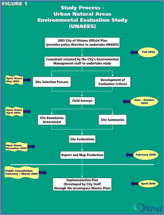
1.3
Study Process
The development of the 2003 City of Ottawa
Official Plan identified the need for evaluation of urban natural areas among
the amalgamated areas of the expanded City.
A number of remnant natural areas both in private and public ownership are
found within the more urban and urbanizing centres for the former cities of
Nepean, Kanata, Goulbourn, Ottawa, Vanier, Rockcliffe, Cumberland and
Gloucester. These remnant areas have,
however, received inconsistent levels of evaluation and policy direction in the
former municipalities Official Plans.
Municipal amalgamation provided an opportunity for a Citywide approach
to a comprehensive, relative environmental values evaluation for remnant urban
natural areas.
The City’s Environmental Management Staff
developed the Terms of Reference for the Urban Natural Areas Environmental
Evaluation Study and completed the consultant selection process in late
2002. Staff then formed the Public
Advisory and Steering Committees to support the study. The Public Advisory Committee supplied community perspective, insights, and
information. It also provided an
initial line of communication to the larger community about the study. Members included representatives from the
City’s Environmental Advisory Committee, expert non-governmental organizations
such as the Ottawa Field-Naturalists and other environmental professionals, and
community groups with an interest in urban natural areas. Members of the Steering Committee included
representatives with expertise in natural environment from the City,
Conservation Authorities, National Capital Commission (NCC), City’s Ottawa
Forests and Greenspace Advisory Committee, and Ministry of Natural
Resources. Staff
and the project consultant worked together to finalize the work plan. A communications plan was then developed.
Public consultation
included the two sets of Open Houses in three different geographic locations in
the west, east and central area with a third open house
in the central location. The communications plan also used interactive
tools such as e-mail, the City web site, as well as distributing study
bulletins and public announcements in French and English newspapers.
Figure 1 illustrates
the study process undertaken for the Urban Natural Areas Environmental Evaluation
Study. Each step of the process is
described in the following sections of this report:
·
Section 2.0 - Site Selection Process
·
Section 3.0 - Methodology
·
Section 4.0 - Evaluation Results
·
Section 5.0 - Analysis of Site Results
·
Section 6.0 - Data Storage and Mapping
·
Section 7.0 - Next Steps
2.0 SITE SELECTION
2.1 Review of Similar Studies
Several studies of municipal natural areas
have been completed in Ontario and other parts of the Country. With an emphasis on the Ontario municipalities,
the review examined the methodology, findings and conclusions of these studies,
including studies of natural areas in Edmonton (Westworth, 2001), Halton Region
(Geomatics, 1993), Markham (Gore & Storrie, 1992), London (Bergsma, 1999), Waterloo (CCL, 1993), and York Region
(Gartner Lee, 1994). Table 1 compares
some of these other studies with the Natural and Open Spaces Study (NOSS)
completed in 1998 for the former City of Ottawa, the Natural Environment
Systems Strategy (NESS) of the former Region of Ottawa-Carleton (1997), and the
current Urban Natural Areas Environmental Evaluation Study.
These studies from other municipalities were most useful in
establishing the evaluation criteria used in the Urban Natural Areas
Environmental Evaluation Study and the corresponding draft thresholds for the
ratings within each criterion.
Including all urban natural areas in Ottawa in
the study made the site selection process more straightforward than in some
other studies. Instead of rating the
sites at this initial stage, all sites with any notable natural feature or
function potential were carried forward for study. Some other municipal studies examined only the potentially most
significant of the total list of candidate urban natural areas (Westworth, 2001), or
examined only remnant natural areas that were not protected by existing
policies (CCL, 1993; Bergsma, 1999).
Other municipal studies examined both urban and rural areas (CCL,
1993; RMOC, 1997, Westworth, 2001) but rural natural areas were not included in
the mandate of the Urban Natural Areas Environmental Evaluation Study. Other studies did not examine the natural
areas in the level of detail completed in the Urban Natural Areas Environmental
Evaluation Study or completed analysis of far fewer sites. In contrast to the 187 urban natural areas
carried forward in this Study, CCL (1993) examined 21 woodlands in the City of
Waterloo and Westworth (2001) evaluated 66 sites in the City of Edmonton.
Looking at the earlier Ottawa NOSS, there are several important
differences. The Urban Natural Areas
Environmental Evaluation Study evaluates only natural features and functions
and restricts the recreational component to implications for maintenance and enhancement
of the natural environment. The NOSS,
however, examined several types of open spaces in addition to natural areas,
including parks, schools, open spaces and manicured green spaces. The NOSS also examined watercourses and
their aquatic habitat. An analysis of
the feasibility of retaining natural areas and open spaces was also conducted
as part of the main study.
Many studies incorporated policy applications and an implementation
strategy (City of Ottawa, 1998; Westworth, 2001). As discussed in Section 7 of this report, policy and implementation
of the Urban Natural Areas Environmental Evaluation Study will be completed as
part of the City of Ottawa’s Greenspace Master Plan.
|
Table 1. Comparison of Municipal Natural Area Studies
|
|
Theme
|
Natural and Open Spaces Study
|
Natural Environment Systems Strategy
|
Edmonton
|
Waterloo Woodlot Study
|
UNAEES
|
|
Municipal area covered
|
City of Ottawa
[former]
|
Region of
Ottawa-Carleton
[former]
|
City of Edmonton
|
City of Waterloo
|
City of Ottawa
[amalgamated]
|
|
Type of area covered
|
Urban
|
Urban and rural
|
Urban and rural
|
Urban and rural
|
Urban
|
|
Purpose of study
|
Facts and policy
|
Facts and policy
|
Facts and policy
|
Facts only
|
Facts only
|
|
Nature of data
|
Ecological and social
|
Ecological
|
Ecological
|
Ecological and social
|
Ecological
|
|
Level of analysis
|
Fine
|
Coarse
|
Fine
|
Fine
|
Fine
|
|
Type of evaluation
|
Comparative
|
Comparative
|
Comparative
|
Comparative
|
Comparative
|
2.2 Approach
to Site Selection
The study area is delineated by the
boundary of the Urban Area as identified Schedule B of the 2003 Ottawa Official
Plan (adopted 2003). Neither the
National Capital Greenbelt nor rural areas in the City of Ottawa were included
in this study. The natural system operating in the rural area of the City of
Ottawa have been studied at a detailed level through such means as Greenbelt
Master Planning, subwatershed studies and the Natural Environment System
Strategy (RMOC, 1997). As well, the Greenbelt and many of the rural portions of
the City include large and diverse natural areas such as Shirley’s Bay, Stony
Swamp, Marlborough Forest, Richmond Fen and Mer Bleue. These areas constitute significant natural
landscapes with more comprehensive systems of natural features and functions
than those in the urban area.
Comparisons among such a spectrum of rural and urban natural areas in a
single study would have been unbalanced.
Land ownership, zoning and development
status were not factors in determining candidate urban natural areas. If the candidate natural feature existed in
the spring of 2003, it was considered eligible for inclusion in the study unless a building permit removing the feature
had been issued for the site.
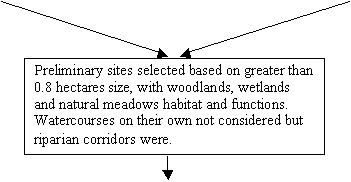
Terrestrial natural features such as woodlands,
ravine systems, and wetlands were all considered in the Study. Although watercourses themselves were not
explicitly studied, the vegetated portion(s) of the riparian corridors along
the watercourses were included as candidate areas. Lands that provide an important associated function for the core
natural area, such as adjacent early successional meadow habitat, were also
included for consideration within the candidate areas. For example, the Britannia Conservation
Area, Navan Road at Page Road, Conroy Swamp and Petrie Island also include
adjacent meadow habitat. The meadow
habitat would likely not be considered an urban natural area site on its own,
but is included as part of the urban natural area site because it adds to the
features and functions of the natural area.
A minimum size of 0.8 hectares was set for
candidate urban natural areas. This was
based on the methodology of other similar technical studies in Canadian
municipalities and the recognition that significant self-sustaining ecological
function is unlikely to occur in an area smaller than 0.8 hectares (Westworth,
2001). If a natural feature, such as a
specialized wetland habitat, of less than 0.8 hectares was noted, however, it
also was eligible for inclusion in the candidate site list. These smaller areas were considered on a
case-by-case basis.
2.3 Identification
of Candidate Sites
As an initial step, 1999 colour aerial photography was used to
identify candidate urban natural areas.
This was augmented by existing environmental inventory reports and
personal knowledge of the City’s natural areas. The existing information included natural environment inventories
and assessments completed as part of the Natural and Open Spaces Study, Natural Environment Systems Strategy, sub-watershed
studies, master drainage plans, environmental assessments and screenings, and
Official Plan reviews, as well as site specific environmental impact statements
and tree preservation plans. The 2003
Ottawa Official Plan was also reviewed to ensure that all lands designated Urban Natural Feature on Schedule B had
been included in the candidate site list.
Input on candidate areas was also received from the Steering and Public
Advisory Committees and the general public.
The candidate urban natural areas were roughly marked on the aerial
maps. A “windshield check” of the areas
in the spring of 2003 provided a field truthing for the initial screening. The “windshield check” provided confirmation
that the candidate urban natural area still existed. Some sites were deleted if major site alterations had recently
occurred which eliminated the potential natural environment feature and
functions on the site, or if the site clearly did not contain natural environment
attributes to merit consideration as a candidate urban natural area. As well, during the “windshield check” some
areas that were not picked up in the initial review of aerial maps were added
as candidate sites based on initial observations of potential ecological
features.
Because of this screening, none of the sites retained for further
study were completely lacking in natural features or value. Regardless of their final evaluation, all
sites studied were included on the list because of apparent natural value.
|
|
|
|
|
|
“Windshield
Survey”
to confirm presence of
feature/function
|
|
|
|
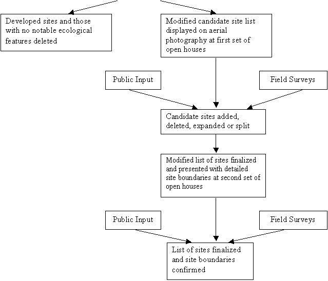 |
2.4 Candidate
Site Results
An initial list of 180 candidate urban natural areas was presented at
the first set of public open houses held in the spring of 2003. For presentation purposes, the urban area
was divided into 4 geographical sub-areas; west, south, central and east. Aerial photography maps of each sub-area
illustrated the identified candidate urban natural areas with a crude polygon
boundary. These maps were also reviewed
by the project Steering Committee and Public Advisory Committee, and were
presented on request to several environmental groups.
From the comments received from the public, various environmental
groups, and the project Steering and Public Advisory Committees, eight new
sites were added to the list of candidate areas. Six sites suggested by the public were added as expansions of
natural areas already on the working list.
There was also some merging and splitting of sites, as recommended by
the public and the study team.
Sixteen sites recommended by the public were not considered to have
natural values, and were referred to the Greenspace Master Plan project
team. Each of these suggested sites was
considered with a field check and/or review of existing background
information. Small site size and poor
site conditions were two key factors in not carrying a site forward as a candidate
urban natural area.
A final list of 187 urban natural areas was compiled and is provided
on Figure 3 and in Annex A of this report.
3.0
METHODOLOGY
3.1 Development of Evaluation Framework
The evaluation criteria are the means for assessing
the comparative ecological features and functions among the urban natural
areas. The criteria provide the vehicle
for transforming the field observations of a natural area into a rating system. The site summaries describe the
characteristics of a site, for example, how old are the trees, how large is the
site, what are the disturbances. The
criteria take these observations and apply an evaluation framework to provide a
comparative rating for each natural area.
This approach allowed for a consistent, comparative, science-based
assessment of the urban natural areas of Ottawa in one field season.
We describe this evaluation framework as
indicators-based. Each of the nine
criteria is an indicator of an aspect of the natural area associated with
ecological value. The links between the
indicator and ecological value is described in the definition of each
criterion. For example, within the
definition of Connectivity (Criterion 1) is the following statement:
Linkages to other urban natural areas such
as woodlots, watercourse corridors and wetlands provide corridors for movement
and assist in maintaining the health of natural communities including diversity
and genetic health.
In other words, more connectivity provides
communities with greater diversity and genetic health, factors in a healthier
and more sustainable natural area.
For a second example, within the definition
of Absence of Disturbance (Criterion 2) is the following statement:
Physical disturbance within habitats
significantly reduces native biodiversity, the quality of ecological functions,
and ecological integrity within natural habitats. The physical condition of the area is a good indicator of overall
natural quality and significance.
The degree of disturbance, in other words,
is a good indicator of the natural quality of an area.
We also call this framework an
indicators-based approach because we are collecting observations of aspects of
the natural areas that go beyond description.
A description would say “The site is 4 ha in area.” An indicator says “This site has an
excellent size, because it is greater than 20 ha in area, and we know that the
larger the natural area, the greater the diversity and quality of ecological
functions the area can support.” Evaluation criteria include both landscape and
site level variables (Bergsma, 1999).
Examples of site level criteria include rare species, absence of
disturbance and regeneration while connectivity and wildlife habitat relate
more to the landscape level.
To develop the framework, we reviewed other
municipal natural area studies (Bergsma, 1999; CCL, 1993; Westworth, 2001), and
particularly the NOSS (City of Ottawa, 1998) and NESS (Region of
Ottawa-Carleton, 1997).
Because of the difference in scope between
the NOSS (City of Ottawa, 1998) and the Urban Natural Areas Environmental
Evaluation Study, many of the evaluation criteria used in the NOSS were not
applicable. These included criteria
pertaining to social values, recreational linkages, watercourses and protection
feasibility. The evaluation criteria
for woodlands and wetlands were quite similar in both studies, although they
were separated in NOSS, while they were combined in the Urban Natural Areas
Environmental Evaluation Study.
The main differences between NOSS and the
Urban Natural Environmental Evaluation Areas Study exist in the application of
the criteria and the thresholds used.
For example, in the Urban Natural Areas Environmental Evaluation Study,
the representative flora criteria examines degree of naturalness and species
diversity in a more quantitative manner than the species diversity criteria for
woodlands in the NOSS. On the other
hand, the absence of disturbance criterion was handled less quantitatively in
the Urban Natural Areas Environmental Evaluation Study than the NOSS. In the Urban Natural Areas Environmental
Evaluation Study, ecological functions were addressed under separate criteria
such as wildlife habitat, connectivity and habitat maturity while in the NOSS
ecological function was a stand-alone criterion. Connectivity is one of the nine evaluation criteria in the Urban
Natural Areas Environmental Evaluation Study, while in the NOSS there is a
separate specific analysis of ecological corridor criteria. The size criterion in the Urban Natural Areas
Environmental Evaluation Study also includes an analysis of the shape of the
natural area. The rarity of woodland
community types was not a separate evaluation criterion in the Urban Natural
Areas Environmental Evaluation Study as it was in the NOSS.
The UNAEES criteria utilize the NESS
principles such as ecological condition, habitat representation, special
features values and wildlife corridor capacity, but have been adapted to
accommodate sites that may potentially be found in a more urban setting. Similar criteria were used by CCL (1993) for
an evaluation of City of Waterloo’s woodlands.
Their five criteria were size, ecological age, habitat diversity,
species (floral) richness and significant species.
Once the evaluation criteria were selected,
there were several key decisions to make including the measuring and scoring
thresholds of each criteria, how many different points there would be for each
criterion, and whether to weight criteria in determining an overall rating for
each urban natural area. The NOSS used
three levels for each criterion in their evaluation framework. However, based on the team’s field
experience and knowledge of natural areas within Ottawa, it was thought that it
would be possible to discriminate more finely in this study. It was therefore decided that the evaluation
framework would include five points for each criterion. These ranged from 5 for high (or most
positive) to 1 for low (or most negative).
We recognize that not all ecological criteria
are equal in importance. However, we
also recognize that it is difficult to quantify these differences in any
meaningful way. We have thus not
attempted to weight the criteria.
Prior to beginning the fieldwork component,
the draft evaluation framework was presented to the Steering Committee, Public
Advisory Committee and at the public open house sessions in the spring of
2004. Several helpful comments on the
individual evaluation criterion were received and incorporated into the
evaluation framework for the field season.
The nine evaluation criteria are described
below, including a definition of the criterion and the thresholds used to give
a 1 through 5 rating for each. In many
cases the thresholds were altered based on the actual fieldwork findings in
order to capture the full range of quality found in the urban area. For example, the thresholds for the size and
shape criterion were modified to cover a broader range of natural area sizes. Instead of the highest score assigned to a
natural area with a size greater than ten hectares, based on initial review of
the findings, the threshold to receive the highest score was increased to
greater than twenty hectares. For the
representative flora criterion, the threshold to achieve the highest score was
decreased to 4.25 from 4.5 after a review of the initial data.
The challenge for the
UNAEES was to provide a comparative environmental evaluation that was standard for all sites, which rated each site on the basis of facts from fieldwork that was reliable, and produced results that can be
replicated. The
evaluation approach adopted by this study is easily repeatable, transparent and
permits re-evaluation under different scenarios such as a change in the scoring
threshold for an evaluation criterion or site alterations in the urban natural
area. However, it is designed to be
used by experienced professional investigators with expertise in ecology.
Evaluation Criterion 1 - Connectivity
Definition:
Linkages to other urban natural areas such as woodlots, watercourse
corridors and wetlands provide corridors for movement and assist in maintaining
the health of natural communities including diversity and genetic health. The connectivity rating also considers restoration
potential and opportunities for site and feature renewal and enhancement. Connectivity is not solely addressing the
physical connection between natural areas, but also evaluates the value of the
ecological function active between the natural areas. This criterion is an example of the evaluation considering the
ecological functions at a landscape level (Bergsma, 1999). When scoring the connectivity criterion the
features and functions of the natural areas that are connected were considered
along with the type of habitat within the linkage itself and the character of
the surrounding land.
|
Rating
|
Connectivity Criterion
|
|
5
|
Excellent
|
Other natural features, such as UNAs, greenbelt and waterway corridors, are
found in proximity to the evaluated urban natural area and the other natural
features possess a variety of positive functions. The connecting corridors are generally in a natural,
undisturbed state
|
|
4
|
Good
|
Other natural features, such as UNAs, greenbelt and waterway corridors,
have a diverse, sustainable character, however the corridors have some
disturbance and/or the natural features are further from the evaluated urban
natural area
|
|
3
|
Moderate
|
Some natural features, such as UNAs, greenbelt and waterway corridors, in
proximity to the evaluated urban natural area, but corridors show a higher
level of disturbance or natural features are limited in function
|
|
2
|
Isolated
|
Natural features in the vicinity of the urban natural area are limited and
linkages to these features are highly disturbed
|
|
1
|
Severely
Isolated
|
No other natural features of note within one kilometre of the urban
natural area
|
Evaluation Criterion 2 – Absence
of Disturbance
Definition: Physical disturbance within habitats significantly reduces native
biodiversity, the quality of ecological functions and ecological integrity
within natural habitats. The physical condition
of the area is a good indicator of overall natural quality and
significance. Examples of serious
disturbances in urban natural areas include the invasion of non-native plants
(herbaceous and woody), the fragmentation of woodland canopies by silvicultural
tree removal, power line right-of-way and roadways, tree forts and fire pits,
trails, dumping of organic yard waste and/or inorganic garbage, direct
encroachment into the natural area by adjacent landowners, and alterations to
surface or ground water functions. The impact of invasive plants was found to
be a major ecological challenge for many urban natural areas. The evaluation of
this factor differentiates between the simple presence of invasives and a
condition when the invasive species significantly affect natural functions of
the area.
|
Rating
|
Absence of
Disturbance Criterion
|
|
5
|
Excellent
|
No notable disturbances observed in the urban natural area and potential
for affects from adjacent land uses are limited
|
|
4
|
Good
|
Only disturbances noted are minor and likely of short duration; few
invasive species, none of which dominate.
|
|
3
|
Moderate
|
Some disturbances are present but the ecological functions of the urban
natural area are not noticeably affected by the on-site and adjacent
disturbances; few invasive species with only local impact on native
vegetation
|
|
2
|
Limited
|
The disturbances are notable either in the area of the disturbance or the severity
of the impact on the ecological functions of the urban natural area; invasive
species common and/or with major impact in the majority of the area
|
|
1
|
Poor
|
Both the area of disturbances and the severity of the impact are
significant; invasive species common and having substantial impact throughout
the site
|
Evaluation Criterion 3 - Habitat Maturity
Definition: Although optimal conditions include a good
distribution and mixture of habitats at various ages, more mature habitats are generally
less common, less disturbed, much more difficult to replace due to their time
dependence (CCL, 1993), and contain a greater number of more valuable
functions. The age structure of the
natural area is a reflection of the land use pattern and history. This factor also considers that some species
and ecological functions are maintained only in mature habitats. This criterion is an example of the
evaluation considering the ecological functions at a community level (Bergsma,
1999).
|
Rating
|
Habitat Maturity
Criterion
|
|
5
|
Excellent
|
Urban natural area contains woodlots greater than 100 years old or other
habitats such wetlands, alvars and prairie habitat in an undisturbed, mature
condition
|
|
4
|
Good
|
Urban natural area contains a good representation of tree stands greater
than 100 years old or other habitats in an undisturbed, mature condition, but
notable portions of the urban natural area are less mature
|
|
3
|
Moderate
|
Urban natural area contains woodlots between 50 and 100 years old or other
habitats in an intermediate successional condition
|
|
2
|
Limited
|
Urban natural area contains a good representation of tree stands between 50
and 100 years old or other habitats in an intermediate successional
condition, but notable portions of the urban natural area are reflective of
early successional habitat
|
|
1
|
Poor
|
Woodlots within the urban natural area are less than 50 years old and/or
other habitats are highly disturbed and at an early successional stage
|
Evaluation Criterion 4 - Natural Communities
Definition: A greater number of natural community types and habitats should result in more diverse and
ecologically important natural heritage functions. A greater number of communities provide the environment for more
and different species within the ecosystem (CCL, 1993). Examples of the potential types include four
wetland habitats (swamp, marsh, fen and bog), and combinations of upland and
lowland forest habitat with deciduous, mixed and coniferous communities. More disturbed habitat such as cultural
meadows and thickets were not included in the analysis of this factor.
|
Rating
|
Natural Communities
Criterion
|
|
5
|
Excellent
|
Urban natural areas with greater than nine natural communities
|
|
4
|
Good
|
Urban natural areas with between seven and nine natural communities
|
|
3
|
Moderate
|
Urban natural areas with between four and six natural communities
|
|
2
|
Limited
|
Urban natural areas with two or three natural communities
|
|
1
|
Poor
|
Urban natural areas with one natural community
|
Evaluation Criterion 5 - Regeneration
Definition: The extent of
natural regeneration of canopy trees is indicative of a healthy,
self-sustaining urban natural area. A
number of factors can negatively affect regeneration, including presence of
invasive non-native species or prevalence of species typical of open/edge
conditions, soil compaction, and changes in soil moisture and light regime
(City of Ottawa, 1998). This criterion
is an example of the evaluation considering the ecological functions at a community
level (Bergsma, 1999).
|
Rating
|
Regeneration Criterion
|
|
5
|
Excellent
|
Regeneration of canopy tree species is high, as indicated by the dominance
and high density of seedlings and saplings of canopy tree species in the
understorey
|
|
4
|
Good
|
Seedlings and saplings of canopy tree species are not dominant in the
understorey, but are well established.
|
|
3
|
Moderate
|
Fair regeneration of canopy tree species, as indicated by some coverage of
seedlings and saplings of canopy tree species in the understorey, but the
density of regenerating stems is lower
|
|
2
|
Limited
|
Wooded areas with limited regeneration of canopy tree species and soil
conditions would suggest greater regeneration should be present. Non-native shrub species may dominate the understorey
|
|
1
|
Poor
|
No notable regeneration or factor not applied to urban natural areas
without wooded areas
|
Evaluation Criterion 6 - Representative Flora
Definition: Species of higher coefficient of conservation and a lower tolerance to
disturbances are generally good indicators of areas with less disturbance,
greater biodiversity and more ecological functions. Richness and diversity are valued as indicators of ecological
persistence and stability (CCL, 1993).
The coefficient of conservation identifies southern Ontario
plants requiring a high degree of naturalness.
Plants with a coefficient of
conservation value greater than 6 generally indicate a high level of naturalness
associated with the area and therefore it is likely that species of
significance are present. At least
thirty-five native plant species must be documented from a site to produce a
meaningful mean coefficient of conservation value. This criterion is an example of the
evaluation considering the ecological functions at a species level (Bergsma,
1999).
|
Rating
|
Representative Flora Criterion
|
|
5
|
Excellent
|
Mean coefficient of conservation is greater than 4.25 or 25 percent of the
native species with a coefficient of conservation greater than 6
|
|
4
|
Good
|
Mean coefficient of conservation is between 3.75 and 4.25 or 20 percent of
the native species with a coefficient of conservation greater than 6
|
|
3
|
Moderate
|
Mean coefficient of conservation is between 3.5 and 3.75 or 15 percent of
the native species with a coefficient of conservation greater than 6
|
|
2
|
Limited
|
Mean coefficient of conservation is between 3 and 3.5 or 10 percent of the
native species with a coefficient of conservation greater than 6
|
|
1
|
Poor
|
Mean coefficient of conservation is less than 3
|
Evaluation Criterion 7 - Significant Flora and Fauna
Definition: Such species are rare
in occurrence (ten or fewer contemporary populations documented within the City
of Ottawa) and/or ecologically important species are generally found in less
disturbed urban natural areas or those areas with greater rehabilitation
potential. These species are excellent
indicators of a high level of naturalness and natural diversity. The species used in this factor are native
flora and fauna, and usually need relatively pristine conditions. The updated treatment of the regionally rare
native plant list constitutes Appendix A of this study. The preliminary list of Brownell and Larson
(1995) was employed to identify regionally rare fauna.
Provincially rare species were those identified by the Natural Heritage
Information Centre with a SRANK of SH, SX, S1, S1S2, S2, S2S3, S3 or S3S4,
including any species endangered in Ontario as per the Endangered Species Act
and species noted as provincially significant in the 3rd Edition of
the Wetland Evaluation Manual (OMNR, 1993).
Nationally rare species are those listed as rare in Canada by Argus and
Pryer (1990) or listed as vulnerable, threatened or endangered in Canada by the
Committee on the Status of Endangered Wildlife in Canada (COSEWIC).
The Species At Risk Act (SARA) which came
into effect early in 2004 requires that protection consideration be given where
federal lands and waters are involved for any floral or faunal taxa listed
[see: http://www.sararegistry.gc.ca/species/default_e.cfm].
There are, however, no floral or faunal species, be they regulated SARA taxa
(Schedule 1) or COSEWIC-designated candidates for SARA protection (Schedules 2
and 3), observed on the federal land examined
during this study.
|
Rating
|
Significant Flora and Fauna Criterion
|
|
5
|
Excellent
|
A nationally rare species or two provincially rare species or more than
five regionally rare species
|
|
4
|
Good
|
A provincially rare species or four or five regionally rare species
|
|
3
|
Moderate
|
Two or three regionally rare species, but no nationally or provincially
rare species
|
|
2
|
Limited
|
No nationally or provincially rare species found and one regionally rare
species
|
|
1
|
None
|
No nationally, provincially or regionally rare species found
|
Evaluation Criterion 8 - Size and Shape
Definition: The area of the
urban natural area often affects the diversity and value of the ecological functions
that the urban natural area can support.
For example, larger woodlands provide more interior habitat than small
stands. In the moderately sized sites,
the shape of the urban natural area is also considered in this factor, as shape
determines the extent of wooded edge relative to the overall ecological
performance. Ecological persistence and
stability tends to increase with size (CCL, 1993). A greater amount of edge habitat in a linear natural area,
although potentially increasing the diversity of available habitat also
increases the opportunities for disturbance (CCL, 1993). Small areas, in the range of 1 hectare can
support common mammals such as muskrats, some forest birds (e.g. black-capped
chickadee and eastern wood pewee) and common amphibians such as green frog and
painted turtle (OMNR, 1999). At four
hectares common edge birds such as downy woodpecker and great crested
flycatcher can be supported, while at ten hectares there is potential for small
areas of forest interior habitat. Four
hectares is often used as the minimal size for functional woodlands (Riley and
Mohr, 1994).
|
Rating
|
Size and Shape Criterion
|
|
5
|
Excellent
|
Urban natural area is greater than twenty hectares in area
|
|
4
|
Good
|
Urban natural area is between ten and twenty hectares in area
|
|
3
|
Moderate
|
Urban natural area is between six and ten hectares in area
|
|
2
|
Limited
|
Urban natural area is between two and six hectares in area, or less than ten
hectares but with a linear shape
|
|
1
|
Poor
|
Urban natural area is less than two hectares in area
|
Evaluation Criterion 9 - Wildlife Habitat
Definition: This
ecological function considers high quality habitat and exceptional faunal characteristics
such as interior habitat and seasonal wildlife concentrations. Interior habitat is less disturbed and
supports disturbance-intolerant ecological features and assets, including rare
species and edge sensitive woodland species that are not tolerant of the
conditions found along the edges of woods. One
hundred metres from a natural habitat edge such as a forest edge or undisturbed
wetland was considered a more realistic characterization of the interior
habitat given the generally urban nature of the study area. (In studies with larger scale landscapes,
such as the Carp River Watershed Subwatershed Study, a factor of two hundred
metres was used). Areas supporting exceptional numbers of particular wildlife
species or function, such as breeding waterfowl, migratory bird staging areas,
or winter roosting and feeding areas for raptors (hawks and owls), constitute
rare natural features within urban landscapes and provide an important
ecological contribution. Similarly, areas functioning as components of wildlife
corridors contribute to both a greater degree of internal and external natural
rehabilitation, restoration and recruitment potential. They thus provide
greater ecological durability for both on-site and connected natural habitats.
This criterion is an example of the evaluation considering the
ecological functions at the landscape, community and species level (Bergsma,
1999).
|
Rating
|
Wildlife Habitat Criterion
|
|
5
|
Excellent
|
Contains more than ten hectares of interior habitat or is critical habitat
for seasonal wildlife concentration
|
|
4
|
Good
|
Contains some interior habitat or provides important habitat for seasonal wildlife
concentrations or rare or uncommon wildlife, or contains significant wildlife
corridors
|
|
3
|
Moderate
|
Provides some seasonal wildlife habitat such as wintering raptors,
waterfowl nesting, bird migration, unique breeding areas including raptor
habitat, cavity nesters or minor denning sites, or provide some wildlife
corridor function
|
|
2
|
Limited
|
Potential for some notable wildlife habitat
|
|
1
|
Poor
|
No particular wildlife habitat attributes
|
3.2 Landowner
Permission
In early 2003, the City’s Surveys and
Mapping Unit provided a database of information to the Project Team, linking
property ownership of candidate natural feature areas and the property boundary
mapping work. Of the 187 urban natural
areas, fifty-seven are City owned, fifty-one are privately owned, and
twenty-seven are owned by other public agencies including the Provincial and
Federal Governments and the NCC. The final fifty-two areas have mixed
ownership, with some parcels owned privately and other parcels owned by public
agencies.
Using this information, both public and
private landowners were initially contacted about the Urban Natural Areas
Environmental Evaluation Study.
Property owners were sent a letter in early May 2003 from the City, notifying
them that their property had been identified as having a natural area of
interest. Also through this letter, the
City requested permission to access their property in order that the field
biologist could visit and record observations on the identified natural
feature. A separate permission form
accompanied the letter and owners were asked to sign off on whether they would
grant or deny property access. This
mail-out package also included the first Study Bulletin, which provided an
overview of the study, its objectives, and a request for public participation.
Efforts were made to send only one letter
and permission form to individuals or organizations that owned more than one
parcel of land that was being considered for evaluation (e.g., NCC, school
boards, developers).
In the weeks that followed, signed
permission forms were sent back to City of Ottawa staff for processing. The access information was matched up with
the natural area of interest and provided to the biologist so he know which
areas he had permission to visit and for which ones permission to access had
been denied. Special instructions
received from the landowners, such as to call ahead of the field survey, were
passed along to the biologist as well.
In some cases, no permission form was returned to the City, or the
letter was returned because the property owner had changed. In these cases, special attention was given
to areas where little or no natural feature information existed. Extra efforts
were then made to identify and contact the owner, and get permission for
access.
As well, where a natural area had several parcels with different
owners, access to some of the parcels was adequate to evaluate the natural
area.
Insufficient access was obtained for twenty-seven of the 187 candidate
sites. For these natural areas,
fieldwork could not be conducted.
However, refusal of access was not reason to delete a site from the list
of candidate sites. The site was
carried forward in the study and included on the mapping. However, the site was not evaluated in
detail and no overall rating was assigned.
The opportunity existed for landowners to
attend one of the Open House sessions in May 2003. However, an additional evening session was held in June 2003
specifically for landowners. They were
invited by letter to attend and learn more about the objectives and intent of
the Urban Natural Areas Environmental Evaluation Study, speak with the
consulting team and City staff, ask questions and provide comments.
3.3 Fieldwork
Program
Once the candidate natural area sites were
selected and the draft evaluation criteria developed, the fieldwork component
was initiated in June of 2003. With the
large number of sites and the higher level of evaluation, it was not possible
to produce detailed vegetation community mapping or comprehensive flora and
fauna inventory for each urban natural area.
The objective of the fieldwork program was to ensure that sufficient
ecological information was gathered to provide a relative environmental
evaluation of each site within the all of Ottawa’s urban natural areas.
For many sites, especially within the
original City of Ottawa, an extensive amount of information was already
available through NOSS and other studies.
For these sites an ecological condition check was conducted. This meant that the validity of the existing
information was verified with a field review of the site in 2003. The data were updated with a description of
the current state of ecological integrity, notes of any significant changes in
the features and functions of the natural area, and reconsideration of the
boundary of each natural area. This was
done while taking into consideration, for example, disturbances from non-native
plants or site alterations.
On sites for which less ecological information
was available, a more detailed field survey was undertaken. This more detailed site assessment included
an examination of representative portions of the different vegetation
communities and landforms of the natural area to identify the ecological
functions of the site.
As described in Section 3.1, the level of
detail for the fieldwork and evaluation of urban natural areas focused on
indicators of ecological values.
Environmental evaluation criteria were selected that provided a good
indicator of environmental value and functions. For example, natural
condition, or the degree to which the natural area is physically disturbed or
in its natural state, is a good indicator of ecological integrity. The presence of rare or ecologically
significant species is an indicator of habitat richness and natural
diversity.
To ensure consistency and continuity,
Daniel Brunton conducted the vast majority of the fieldwork.
3.4 Data Collection and Field Surveys
Detailed
aerial photography, using high-resolution 2001 black and white images, was
produced for each urban natural area at a scale of 1:3,000. These images were of assistance in the field
to undertake site descriptions and delineate the natural feature boundary for
the site.
Field investigations of the urban natural
areas occurred in the late spring, summer and early autumn of 2003. The
full field assessment season ended in early October. Ecological condition checks were conducted until late November.
The surveys not only identified the
flora and fauna present and evident, but also documented the ecological
conditions under which each ecosystem is operating (CCL, 1993). The field investigations collected information on forest stand
ages, natural area size, number and rarity of community types, flora and fauna
species, disturbance levels, ecological functions, geological landforms, other unique attributes,
linkages to other natural areas, wildlife habitat, wildlife usage and
corridors, and existing recreational uses. Site disturbances such as non-native species, trail use, dumping, and
vandalism were recorded. Physical characteristics assessed included
topography, soils and moisture regime. The floristic records included both
representative and distributionally significant species.
Vegetation communities were described
based on dominant species, locations of standing water and other drainage
observations, health, age, topography and soil conditions. The vegetation communities were identified using
the terminology recommended by the Ecological Land Classification system (Lee
et al., 1998), although the habitats were classified at a higher level than
that completed for a detailed site assessment.
For example, wetland habitat may be described as meadow marsh habitat
for the Urban Natural Areas Environmental Evaluation Study. For a detailed site assessment, a specific
type of meadow marsh such as a reed canary grass, sedge, jewelweed or bluejoint
organic or mineral meadow marsh would be described.
The species list presented as part of
the site summaries focuses on native flora species. The list is not intended to be an exhaustive list of all native
vegetation in a site. Rather, the flora
species lists provide an excellent indicator of the floral composition of the
natural area. Although not included in
the species list, the distribution of non-native species was noted and the
information used in the evaluation criteria and presented in the site
summaries. The Urban Natural Areas
Environmental Evaluation Study provides important and useful information on
habitat biodiversity, while providing the framework for more detailed
site-specific studies if required in the future.
The
Natural Heritage Information Centre (NHIC) database was utilized to provide
characteristics of the vegetation species identified with respect to
naturalness (coefficient of conservation), wetland affinity, weediness,
introduced plants, potential impact on native flora, and level of
disturbance. Potential habitat for amphibians and reptiles was
examined, including the underside of logs and other woody debris.
Fauna data require considerably more
effort to gather, are typically more seasonally constrained, and individually
often present less valuable analytical information than vascular plant data.
Accordingly, in this study faunal data, as is typical of such inventory and
assessment programs, were largely gathered incidentally during vegetation,
floristic and ecological function investigations. All incidental mammal, amphibian, reptile and
bird occurrences noted during field surveys were incorporated into the
information compiled for each site.
GPS readings were taken of significant
findings, such as areas of rare flora.
In addition, voucher
specimens and photos were taken to ensure verification of uncommon plant
species. Other
information such as existing access points and other disturbances was collected
to assist in the evaluation of management recommendations and potential passive
recreational opportunities. Digital
photographs were taken of many features, including topics related to management
recommendations.
For each natural area, the major
components of the documentation resulting from the field investigations and
background reviews are:
·
A
brief biophysical description;
·
Identification
of ecological conditions;
·
Vegetation community descriptions;
·
Identification
of special features and significant ecological functions;
·
Annotated
lists of floral and faunal field observations
(including coefficient of conservation values); and,
·
Ecological and recreational management
recommendations.
|
TABLE 2 - UNAEES SITE
SHEET
Description:
Site details:
a) Size: b) Ownership:
Ecological Functions:
a) Connectivity (distance to
other natural area(s) and type (woodland, stream corridor, meadow):
b) Interior habitat:
c) Disturbance (degree and
duration) and condition:
d) Adjacent land use
impacts:
e) Invasive plants (species
& status – present, established, problematic):
Native Biodiversity:
a) Habitats (type and
dominants):
b) Representative flora/ fauna
(appended list of native flora and fauna):
c) Significant features and
species (species and designation):
Ecological comments:
a) Management (opportunities
for enhancement of natural environment assets):
b) Recommendations:
Research:
Low
impact recreation opportunities:
Site investigation details:
Date(s)
and conditions:
Investigator(s):
Other comments: (field conditions, photographs taken,
etc.)
References:
|
3.5 Recreational Component
Natural areas often provide opportunities for unstructured
recreational uses such as walking and can offer an alternative to developed
urban parks and corridors. While these sites
may not have an official “park” status they are often highly valued by nearby
residents. There is often a significant
interest in preserving these natural areas and ensuring that whatever
recreational activities take place, are compatible with the natural values.
Natural areas exist within the larger context of green
spaces in the City. Natural features
and functions are paramount. However,
where those features and functions no longer exist, or cannot be restored,
sites may have other values that can make a contribution to community well
being as part of the larger consideration of green spaces in the City.
Developing a sense of stewardship in the geographic
community surrounding a natural area is one of the best ways of protecting a
site and its features and functions. A
community of interest (e.g. community associations) can also provide important
protection. Sense of stewardship and
responsibility can be fostered by information and education about the site, for
example, through schools, nature groups, youth groups, senior’s groups, and
community fairs. Signage can also play
an important role in building community awareness and involvement.
Site use can also enhance security of the site (eyes on the
site, like eyes on the street).
However, some security measures would be damaging and inappropriate in
all or some natural areas (example: trimming bottom branches of trees up to 6
feet from the ground to improve visibility and reduce hiding places along a
pathway).
The recreational component of the Urban Natural Areas
Environmental Evaluation Study did not aim to conduct a recreational planning
exercise. Rather, the study maintained
an ecological focus. The fieldwork
identified and assessed any threats to environmental features and functions from
recreational activities. In addition,
the study identified opportunities to provide or enhance low impact
recreational activities without compromising the integrity of the natural
features.
Fieldwork documented evidence of existing activities, such as
pathways or trails. Where appropriate,
management recommendations for individual sites include measures necessary to
protect the natural features. For
example, fieldwork may have identified numerous pathways through a wooded or
wetland area. The management
recommendation might be to consolidate all the pathways into one more formal
stone dust path, with an indication of where it might be located, or which
locations should be avoided. In
addition, the recreational recommendations might suggest signage along the
pathway interpreting particular natural features. The signage would encourage use of the formal pathway (instead of
continuing to make random paths) at the same time as it provided valuable
information about the natural features of the area to recreational users.
3.6 Database Production
The data collected have all been synthesized into electronic
files. The site summaries for each
urban natural area, including the significant and representative species,
description of vegetation communities, existing and potential disturbances,
linkages, management recommendations, rating evaluation matrix and native flora
species list are in Microsoft Word documents, one per natural area. The urban natural area mapping is available
as a pdf file and has also been included in the City’s ArcView GIS database.
The initial site mapping was developed by Isosceles Information
Solutions Inc. from electronic files received from the City including
orthorectified imagery along with any ancillary vector layers (OBM digital
files). The imagery, along with the
vector layers was brought into ArcView 8.1 where the urban natural areas were
plotted on paper sheets for use in the field.
After the natural area boundaries were added to the paper sheets,
Isosceles then scanned and georeferenced the natural area boundaries into Micro
station. A unique ID value was attached
to the polygons that corresponded to a record of information in a tabular
database. The polygon data layer was then converted to a shape file format for input
to the City’s GIS database.
The electronic copies of the site
summaries, site ratings and individual site maps are found in Annex A of this
report.
4.0 EVALUATION RESULTS
One hundred
and eighty-seven (187) natural areas were brought forward from the site
selection component of the Study. The
sites are shown on the citywide map at the end of this report. Figure 3 - Site Evaluation Results Map shows the overall environmental rating of a
site, where it was evaluated. Where a
site was not evaluated, this is shown instead of a rating. The environmental rating and site boundary
do not consider past or present planning decisions, ownership or landowner
intent for the area. The map represents
the physical boundary of the natural area and the environmental value of the
natural area based on 2003 field assessment.
Planning and policy decisions on urban natural areas will be determined
through the Greenspace Master Plan process.
The purpose of this section is to summarize the evaluation results based
solely on environmental values.
The 187 natural areas
cover approximately 2,660 hectares of the City’s urban area, or 7.7 percent of
total land surface area within official urban boundary (minus the surface areas
for the Rideau and Jock Rivers, Dows Lake and the Rideau Canal). The work on one hundred and fourteen (114)
urban natural areas are considered complete.
These sites have been evaluated and rated using the Study
methodology. Evaluations were not
completed for seventy-three (73) sites.
For twenty-four (24) of the remaining natural areas, a significant
amount of ecological information exists:
These areas require only an ecological condition review in order for the
evaluation criteria to be applied and a rating assigned. The remaining forty-nine (49) natural areas
require a field assessment prior to proceeding with evaluation and rating. Adequate access was not obtained for
twenty-seven (27) of these natural areas.
Evaluations for the balance of forty-six (46) sites were not completed
due to time limitations imposed by the field conditions.
4.1 Urban
Natural Area Boundaries and Mapping
After each field investigation, detailed
site boundaries were established on the 1:3,000 aerial photography (2001) for
each natural area. Boundaries were
chosen to encompass the habitats, vegetation communities and species that
combine to constitute an approximate ecologically unified area (RMOC, 1997). Boundaries were stopped at notable roads and
major disturbances that clearly divide the natural area attributes. The division of these attributes is not so
clear with mature habitats and the impacts of roads were not as significant in
these examples. Areas of high human
impact and human-dominated landscapes, such as mowed fields and farmland, were
excluded where they were not considered important for maintaining the
ecological value of an area. However,
the natural area may include
components on either side of a disturbance such as a road if the components
appear to be historically related. In
some cases, additional environmental investigations may result in boundary
refinements. The present investigation identifies
boundaries that enclose all of the significant natural ecological features and
values identified by site investigations.
Most if not all meadows in the urban
portion of the City of Ottawa are cultural meadows of artificial origin and
thus of limited intrinsic natural environment value. Nonetheless, these can provide valuable ecological resources for
adjacent natural features by offering potential for the establishment of
ecological buffers and transition zones between natural habitats and ‘outside’
influences. They can also provide
useful habitat (feeding, shelter, etc.) for wildlife species utilizing adjacent
natural areas and can contribute to ecological functions such as the protection
of groundwater sources. Accordingly,
areas of regenerating meadow habitat that offer significant wildlife habitat or
contribute to the ecological functions of adjacent natural areas have been
included within the boundaries of urban natural areas defined in this
study. For example, the meadow habitat
adjacent to McCarthy Woods provides feeding habitat for raptors and other
wildlife found in the forested core of the natural area. The rationale is developed on a case-by-case
basis, depending on the actual or potential contribution of the regenerating
meadow area to natural environment features and functions.
The boundaries for each natural area were
determined with the following additional guidelines:
- the initial site identification was based on the size criteria
of 0.8 hectares or larger;
- the natural area represents a contiguous natural site;
- the boundaries of natural areas do not include major
disturbances such as residences, manicured areas, agricultural lands or
major roads, however the
natural area may include components on either side of a disturbance such
as a road if the components appear to be historically related;
- although watercourses are not directly
evaluated in this study, a natural area could include the riparian
vegetation along a watercourse and the wetland habitat within the river or
lake;
- the natural area boundaries were
delineated on 2001 black and white photography at a scale of 1:3,000 and
then digitized into GIS;
- property lines were not considered in the
development of the natural area boundaries;
- planning decisions and property ownership
were not factors in determining the natural area boundary; and,
- the boundaries of the natural areas
terminated at the urban area boundary as defined in the 2003 City of
Ottawa Official Plan. However
natural features on adjacent lands outside the urban area are considered
in the evaluation (e.g. connectivity).
Some of the urban
natural areas boundaries in this study may differ from the boundaries
determined in NOSS for natural features in the former City of Ottawa. Boundary changes could be attributed to
succession, removal of natural areas, ice storm damage, and other changes in
land use over the past seven years since NOSS fieldwork was conducted.
4.2
Site Ratings
Establishing firm thresholds of ecological
significance is no more or less a numerically hard and fast process than are
the ecological parameters themselves.
The determination of ecological thresholds and significance is not an
engineering exercise. In other words,
when reviewing the significance of candidate urban natural area sites we are
addressing a variety of interconnected but also distinct variables. When considered in combination, however,
these criteria collectively differentiate higher or lower levels of
significance. By assigning measurable
value ranges (numerical or otherwise) within each of the ecological
significance criteria we are evaluating, we can defensibly identify overall
patterns of importance on a Low to High scale.
As discussed in Section 3.6, each natural
area was evaluated under nine criteria, and each criterion was rated 1 through
5, with a rating of 5 being the most ecologically valued or least
disturbed. These nine individual
ratings were then combined to give an average rating for the natural area. This rating was used to generally group the
natural areas into three levels; a rating of less than two (Low), a rating from
two to less than three (Moderate) and a rating of three or greater (High). The overall rating of the nine evaluation
criteria for each urban natural area ranged from 1.11 to 4.67.
Once all the evaluated natural areas were
assigned an overall rating, the list of low, moderate and high sites was
further reviewed to confirm that each natural area was properly rated. Preliminary sensitivity testing of the
methodology indicates that the numerical evaluation of criteria has been very
accurate in identifying relative levels of ecological significance among the
evaluated urban natural areas.
Nonetheless, the ultimate assessment of each site has been ratified or
qualified on the basis of our field-based professional experience of the
ecological features and functions of the natural areas and regional landscape,
and judgement in assessing ecological system thresholds and values. This
enables the findings to better reflect the full range of ecological values and
benefits each particular site has to offer.
We have
avoided attempting to formally weight the degree of these evaluator
differences, however it is recognized that particular attention should be paid
to a subset of especially important ecological evaluators for confirming the
overall site ratings. These four
criteria, size and shape, absence of disturbance,
representative flora, and significant flora and fauna, are particularly powerful tools in
determining overall site value. Approximately ten percent of the overall
site ratings were adjusted to reflect the importance of these criteria.
The overall site ratings were presented to
joint meeting of the Steering Committee and Public Advisory Committee in
November 2004. In addition, the ratings
of each evaluated site was depicted on a Citywide, urban map and sub-area maps
(east, west, central and south) during the third open house for this study
(December, 2004). This was the first
opportunity for members of the public to review the results of the environmental
evaluations that were completed on 114 urban natural areas. Members of the consulting team were
available at the open house to discuss the evaluation process and provide
explanations for the final ratings.
Table 3 summarizes the overall rating of each
evaluated site by geographical sub-area as well as representation citywide.
|
Table
3. Summary of Overall Natural Area
Ratings by Urban Sub-Area.
Percent = the
percentage of all sites evaluated to date
|
|
Sub-Area within City of Ottawa’s Urban
Area
|
Sites High Overall
|
Sites Moderate Overall
|
Sites Low Overall
|
Total Sites Evaluated to Date
|
Sites to be Evaluated
|
|
No.
|
Percent
|
No.
|
Percent
|
No.
|
Percent
|
|
West
|
6
|
26
|
10
|
44
|
7
|
30
|
23
|
12
|
|
Central
|
16
|
22
|
24
|
33
|
32
|
45
|
72
|
24
|
|
South
|
3
|
38
|
3
|
38
|
2
|
25
|
8
|
24
|
|
East
|
4
|
36
|
4
|
36
|
3
|
28
|
11
|
13
|
|
Totals
|
29
|
25
|
41
|
36
|
44
|
39
|
114
|
73
|
Twenty-nine (29) natural areas were rated high
overall, forty-one (41) rated moderate and forty-four (44) rated as low
overall. The forty-four low overall
rated sites represent 39 percent of the sites with evaluations completed, while
the twenty-nine high rated sites represent 25 percent. The twenty-nine natural areas rated high
overall cover 860 hectares, with the moderate and low
sites representing 450 and 129 hectares, respectively. All of the sites that were proposed as an
Environmentally Significant Area (Brunton, 1993) or a life science Area of
Natural and Scientific Interest (Brunton, 1992) were ranked high overall.
The distribution of high, moderate and low overall rated natural
areas was generally consistent over the four sub-areas of Ottawa’s urban area
(Table 3). Although the central area
contained the greatest number of high overall sites, it also had more than
twice as many total sites evaluated to date.
The percentage of sites rated high overall (22 percent) in the central
sub-area was actually the lowest among the four sub-areas. Correspondingly, the central sub-area had
the highest percentage of natural areas rated low overall. Caution is required in this component of
the analysis due to the low total number of sites evaluated in the south and
east sub-areas.
Sites Rated Low Overall
·
The low overall rated sites generally
scored three or higher only for the connectivity and habitat maturity
evaluation criteria.
·
There were no ‘5’s assigned to an
individual evaluation criterion for a site rated low overall.
·
A few low overall rated sites scored
‘4’ for regeneration (Abbott/Iber Woodlot, Cedarview Woodlot and Assaly Woods).
·
Disturbance, natural communities,
representative flora, significant flora and fauna, wildlife habitat and size
and shape were the individual criteria generally resulting in the low overall
rating.
·
Of the natural areas rated low
overall, only Abbott/Iber Woodlot and Chaudiere Rapids scored higher than a ‘2’
for disturbance and representative flora, respectively (both ‘3’s) and only
Pinecrest Cemetery, West Hunt Club, Conroy Woods and Aviation Parkway South
scored higher than a ‘2’ for size and shape (all ‘3’s). Pinecrest Cemetery and Riverside Park Woods
scored a ‘3’ for wildlife habitat, all of the other low overall rated sites
scored ‘1’ or ‘2’ for the wildlife habitat criterion. None of the natural areas rated low overall scored higher than a
‘2’ for the natural communities or significant flora and fauna evaluation
criteria.
Sites Rated Moderate Overall
Sites Rated High Overall
The urban natural areas ranged in size from 0.36 hectares to 134.2
hectares. Once the detailed site
boundaries were established, five of the evaluated natural areas were less than
0.8 hectares. Since these natural areas
were all rated low overall, there would appear to be no special characteristics
that would merit further inclusion of these sites in the Study, but because
these sites at the onset of the study were considered to be greater than 0.8
hectares, they will be maintained due to the value of the information
provided. The reduction in natural area
size from the initial review was in some cases due to recent development on
part of the site, or for others a more detailed examination refined the natural
area boundary to less than 0.8 hectares.
The average Coefficient of Conservation value for the natural areas
ranged from 4.81 (Britannia Conservation Area) to less than 2.5 for many of the
sites rated low overall. The greatest
number of significant flora and fauna amongst the completed evaluations was 44,
also at the Britannia Conservation Area, followed by Trillium Woods (21
significant flora) and Champlain Bridge Islands (18). Petrie Island, currently with an incomplete evaluation, is
another natural area that will likely score very well for many of these
criteria.
4.3
Management Recommendations
The site summary for each evaluated urban natural area (found in
Annex A) identifies management recommendations for the rehabilitation,
protection and enhancement of each natural area. The recommendations may be operational in nature, with the
emphasis on mitigating observed disturbances or other existing negative impacts. Or the recommendations may suggest tools for
rehabilitating or enhancing the ecological and recreational features and
functions of the natural areas.
Examples of ways to mitigate disturbances include control of non-native
plant populations or realignment of an informal trail away from more sensitive
portions of a natural area.
Regeneration of the forest canopy, naturalization of vegetated buffers
between adjacent developments and natural areas, and greater awareness through
interpretative panels are examples of potential enhancement measures.
The recommendations are to be treated as guidelines only, and
subject to landowner approval. The
management recommendations were developed principally from observations during
the field surveys and knowledge of the types of enhancements warranted along
with recommendations in existing studies, notably the original City of Ottawa’s
NOSS (City of Ottawa, 1998) and the NESS (RMOC, 1997).
Provisions must be in place for maintaining
urban natural areas into the future if the urban natural area is to ultimately
sustain itself over the long term. The
old belief that urban natural areas do not need management because they are
“natural” is no longer an adequate management option in a predominately
developed landscape (Westworth, 2001).
Site-specific recommendations are provided in each site
summary. However, some examples are
described here to provide an understanding of the type of measures that have
been recommended.
4.3.1
Ecological Management Measures
The management recommendations from an ecological perspective can
generally be broken down into two categories; mitigation of existing
disturbances, and maintenance and enhancement of existing positive features and
functions.
Mitigation
of Existing Disturbances
Restoration recommendations, such as
vegetating exposed soil, removing invasive species, regrading and vegetating
gully erosion and eliminating grazing in natural areas, are examples of
ecological management recommendations applied to the urban natural areas. Natural re-vegetation of creek-side ground
vegetation is required to control erosion and add to the natural functions at
Katimivik Park and Cattail Creek Park Woods, for example.
Alice Wilson Park in the west end is an
example where physical removal of the most serious invasive flora (black
swallow-wort and celandine) is required to prevent these populations from
becoming fully established. A similar
theme exists for the immediate eradication of spotted knapweed at the periphery
of Airbase Woods. Buckthorn control is
needed in many areas, including Hazeldean Woods Park, Hospital Woods East,
Conroy Swamp, Vincent Massey Woods, Champlain Bridge Islands, NRC Woods South,
Carson Grove Woods, Terry Fox School Woods, Rockcliffe Park West, McCarthy
Woods and Lower Bilberry Creek Valley.
Garlic mustard is a serious problem at Hazeldean and Katimivik Park
Woods and the Britannia Conservation Area, with Norway maple and tartarian
honeysuckle also a severe problem at Britannia Conservation Area. Pioneering growth of garden invasives
should also be controlled at the Half Moon Bay natural area.
Population control of aggressive and
non-endemic Canada Geese is recommended for the Britannia Conservation Area to prevent increasing
loss of breeding habitat for native waterfowl.
The exceptional aquatic floristic association at Des Chênes Lookout
requires protection from heavy recreational abuse of shoreline vegetation and
subsequent impact on water quality, including prevention of feeding of
waterfowl. The rehabilitation and
naturalization of the shoreline vegetation is required to enhance protection of
shoreline and shallow-water wetland communities.
Re-vegetation of abandoned pathways and
service corridors is important as these disturbances are removed from
service. An example is the relocation
of Goulbourn Forced Road out of the centre of Trillium Woods, and
rehabilitation of several informal tracks and pathways. Natural rehabilitation should also be
encouraged adjacent to the long sewer line right-of-way in Heart’s Desire
Forest. Re-vegetation with diverse
native species will assist in reducing the spread of invasive flora.
Removal of garden waste and composters are
important for several of the urban natural areas to reduce the ease which
invasive plant species can spread into, and become established in the natural
areas. This was noted, for example, at
Morgan’s Grant Woods, Hazeldean Woods Park, Britannia Conservation Area, Airbase Woods, Lower
Stillwater Creek, Bilberry Creek Valley, Chapel Hill Park and Ski Hill Park
natural areas.
Maintenance
and Enhancement of Ecological Functions
Urban natural areas can be enhanced through
increasing the amount of natural habitat by naturalizing service corridors,
planting the periphery of the natural areas with native woody vegetation and
ground flora, or adding to the natural heritage features and functions on
adjacent lands.
Retention of a continuous canopy cover
within existing forests is crucial in maintaining integrity, including
retarding the spread of invasive flora.
This recommendation is given for many sites with good forest cover
including Trillium Woods, South Richardson Forest, Whelan Park, Lower
Stillwater Creek, Tallwood Woods, Hazeldean Woods Park, Pine Glen Park, Ski
Hill Park, Remer Property, Marchwood/Lakeside NEA A, Airbase Woods, Nivens
Woods, Memorial Gardens Woods, Jockvale Road Woods, Britannia Conservation
Area, Chapel Hill Park, Vincent Massey Woods, Champlain Bridge Islands,
McCarthy Woods, Conroy Swamp, Rockcliffe Parkway, Elmhurst Street Woods,
Rockcliffe Park West, Forestglen Park, Bypass Woods, Church Woods at Innes,
Morgan’s Grant Woods and Louis Perrault Park.
Restoration with native species is required
in the existing canopy clearings of Katimivik Park Woods to retard further
spread of non-native flora. Maintenance
of forest canopy is required to sustain the wooded slopes at Escarpment Park
Woods. Opportunities exist for slope
naturalization, centred on the maple forest fragment, along the north side of
Graham Creek within the Monterey Ravine natural area. In some of the smaller forest urban natural areas such as
Manordale Woods, it is especially important to protect mature trees to maintain
the natural significance of the woodlands.
A vegetated buffer between adjacent
development and woodland areas is required to reduce edge effect. Recreation of a stable woodland edge
prevents wind throw or sun-scald of trees that have grown in the sheltered
conditions of woodland interiors, and decreases the potential for invasion of
edge or field species into the forest interior (City of Ottawa, 1998). This management recommendation applies to
many areas, including Trillium Woods, Alice Wilson Park, Ski Hill Park, Nivens
Woods, South Richardson Forest, Marchwood/Lakeside NEA A, Vincent Massey Woods,
Rockcliffe Park West, McCarthy Woods, Tallwood Woods, Forestglen Park, Church
Woods at Innes, Jockvale Road Woods and Memorial Gardens Woods. At Hazeldean Woods Park and Arlington Woods
Park, such buffers are required between the recreational fields and the wooded
areas.
Plantings within and adjacent to urban
natural areas should be native species only.
It is also critical to use rodent guards on trees and to monitor the plantings
for at least two years to optimize potential for survival. Rodent guards and stakes must be removed as
the trees take hold, and all vegetation that dies should be replaced. A maintenance free area is necessary around
the base of the plantings. As opposed
to natural succession, plantings provide the opportunity to emphasize the
desired native species to promote natural diversity and to discourage
domination by non-indigenous trees and shrubs.
For example, buckthorn shrubs or poplar trees now dominate many areas in
the Ottawa area that were left to succession.
In addition to new plantings, transplanting of existing desirable
species, acclimated to the local conditions, is a natural enhancement that is
cost-effective and could be used much more often.
At Escarpment Park Woods, reduction of
maintenance in proximity to the natural area, such as a ‘no-mow’ buffer on the
top edge of the escarpment, should reduce slope erosion and encourage natural
vegetation regeneration. A similar
buffer would be beneficial at Hope Cloutier and Stittsville Arena Parks,
between the adjacent development and manicured park and the watercourse and
riparian vegetation within the natural areas.
A naturalized buffer is needed between manicured lawns and the riparian
corridor along the Poole Creek Corridor natural area, as well as along the
Monterey Ravine and Graham Creek, and portions of the Nepean Creek
Corridor. Enhancement of the
protective natural shoreline vegetation buffer is also required at Half Moon
Bay natural area on the Jock River.
Rehabilitation of the natural areas will of course benefit the
associated watercourses for the above natural areas.
Many other natural areas have mowed lawns
right to their boundary and would benefit from a naturalized buffer. Examples include Bell Memorial Park, Lower
Stillwater Creek, Chapel Hill Park and Leslie Park Ravine. The latter natural area would benefit from
the naturalization of slopes (including removal of obstructing fencing) to
encourage sustainability of protective vegetation.
Plantations were not common in the urban
natural areas, but where they exist, such as within the Jock River Landing
natural area and a small portion of Heart’s Desire Forest, efforts should be
made to complete a significant thinning of plantation cover to encourage
natural regeneration. Another example
is in the Elmhurst Street Woods natural area, where conifer and honey locust
plantation trees by Frank Ryan Park should be removed.to permit the restoration
of native vegetation.
The maintenance of the existing water table
elevation and other components of the moisture regime is important for the
sustaining health of wetland habitat.
This is often quite challenging in areas of predominantly existing or
anticipated urban development such as adjacent to Hazeldean Woods Park, Church
Woods at Innes, Remer Property, Louis Perrault Park, NRC Woods South, Conroy
Swamp and Bell Memorial Park. Closure
of drainage channels in the Bypass Woods is recommended to maximize water table
storage. Long-term viability of
ephemeral woodland pools in the Bridlewood
Core Park natural area south of Kakula Road is
important for significant species (red-shouldered hawk) and habitat integrity.
4.3.2
Recreational Management Measures
Mitigation
of Existing Disturbances
A major recommendation associated with
recreational use within and adjacent to an urban natural area is restriction of
access to a designated trail network.
It is recognized that the total exclusion of people from an urban
natural area is not warranted or desirable.
However there are examples of portions of an urban natural area where
access should be restricted. For
example, in Trillium Woods provision of a single rock-crush footpath in the
western portion of the site would reduce the overall disturbance and has
considerable interpretive potential.
The rehabilitated roadways in Trillium Woods provide opportunities for
bicycle trails. Exceptional potential
for pedestrian pathways and associated representation of Provincially Rare
Canadian Shield habitat exists in the Marchwood/Lakeside NEA A. No pathways are recommended for Upper Duck
Island, with the existing water-based access considered appropriate for the
fragile landscape values.
A number of natural areas included wide
pathways or several informal pathways that could negatively impact habitat
continuity. Directing pedestrian
activity to the periphery of the urban natural area is recommended for natural
areas such as Trillium Woods, Britannia Conservation Area, Forestglen Park, Chapel
Hill Park and Alice Wilson Park, while rationalizing informal trails at natural
areas such as Pine Glen Park, Ski Hill Park, McCarthy Woods, NRC Woods South,
Elmhurst Street Woods and Queensway Park.
This mitigation measure will reduce the overall disturbances caused by
trampling, vandalism and physical impact on vegetation.
Diverting traffic from locations of
significant species was recommended for natural areas with populations of
unique plants in areas such as Morgan’s Grant Woods and Bypass Woods. Footpaths at Katimivik Park, Escarpment
Park, Poole Creek Corridor, Bell Memorial Park, Barrhaven Escarpment,
Rockcliffe Park West, Leslie Park Ravine and Cattail Creek Park Woods appear to
be at capacity, and users should be given suitable alternatives at the edge or
outside of these relatively small urban natural areas. At Escarpment Park Woods and Monterey
Ravine, the pathways along the eroding slopes should be rehabilitated or
redirected to more stable areas.
Pedestrian-friendly barriers at trail access
points are important to avoid illegal dumping and reduce use of motorized
vehicles in urban natural areas.
However, no areas were observed where it was considered necessary to
establish permanent fencing to exclude access from a particular portion of an
urban natural area.
Maintenance
and Enhancement of Natural Area Functions
In many cases the existing footpaths with
no formal construction and material are sufficient. However, in areas of existing erosion or high use, woodchips or
stonedust should be used. For example,
in Alice Wilson Park and NRC Woods South centralization and deployment of
stonedust surface of existing trails will improve recreational opportunities
and reduce site erosion. Similar areas
of erosion were noted along the informal pathways in Hazeldean Woods Park and
Carson Grove Woods. Asphalt is
generally discouraged due to its unnatural features, cost including sub-base
preparation, and potential impacts on surface runoff, treatment and infiltration. Woodchips may be preferred over stonedust
where it is desirable to discourage motorized vehicles and mountain bikes. Impacts of mountain bikes was noted as a
potential serious concern at Forestglen Park, Chapel Hill Park and
Marchwood/Lakeside NEA A natural areas.
In low-lying areas, sections of boardwalk will increase all-season trail
accessibility and limit the area of disturbance.
Some treatment on recreational pathways is
also recommended in other sensitive habitats noted in the urban natural
areas. For example, at the Kanata Town
Centre natural area there appears to be the need for a low impact footpath,
using material such as stonedust, in the woodland and sensitive outcrop habitat
to manage pedestrian traffic and reduce the impact on slopes and the fragile
outcrop vegetation. In Young’s Pond
Park, there is the need to upgrade the existing informal trail to protect roots
of the larger trees from increasing erosion.
A stone dust footpath in the woodland habitat of Heart’s Desire Forest,
especially near the river is required to manage pedestrian traffic and reduce
impact on slopes.
Such formalized pathways also provide
excellent potential for interpretative panels on natural heritage themes, for
example the natural biodiveristy, hydrological contribution, microclimatic influence
and ecological corridor functions of Hazeldean Woods Park, Conroy Swamp,
Memorial Gardens Woods, Britannia Conservation Area, Vincent Massey Woods, Jock River Landing, Rockcliffe Parkway,
Bilberry Creek Valley and the Nepean Creek Corridor. At Stittsville Arena Park and the Poole Creek Corridor natural
areas, there is excellent interpretive potential for the footpaths along Poole
Creek and through mature maple forest in the southwest portion of the natural
area. The footpaths need to be
upgraded to reduce soil compaction, tree root damage and bank erosion along the
creek.
Signage is important to provide the public
with not only increasing awareness of the urban natural area and associated
natural heritage interpretation, but also to identify site-specific disturbance
issues and corresponding remedial measures.
In some urban natural areas, such as
Morgan’s Grant Woods, active recreational facilities such as basketball courts
or ball diamond outfields have encroached into the natural area. Research is recommended to identify options
for reducing the impacts of such recreational developments on the ecological
integrity of the natural area, including perhaps the removal or reduction in
size of the facilities, modifications to the lighting, and use of stonedust or
woodchip pathways rather than asphalt.
In many urban natural areas, there is the
potential for creation of new trails linking existing adjacent facilities such
as schools and active parks. For
example, there is good potential for an east-west recreational footpath across
the Whelan Park natural area, avoiding the regionally rare and uncommon
flora. Similarly, an east-west pathway
could be constructed through the less sensitive northern portions of Aviation
Parkway North to link the relatively new Whiterock Park with the residential
communities and existing parks west of Aviation Parkway. A new linkage between recreational
facilities would also be helpful at Young’s Pond Park, as would additional pathways
at Bypass Woods. Excellent hiking trail
potential exists in Airbase Woods.
Recreational pathways within the edges and
adjacent to natural areas will provide an excellent interpretive opportunity
for addressing ecology of wetlands, significance of ground water source
protection and ecological connectivity within urban landscapes. Excellent interpretative opportunities exist
along ‘The Cowpath’ in Elmhurst Street Woods, the Albion wetland associated
with the Remer Property, and in Airbase Woods regarding the river formation
phenomena and post-glacial Champlain Sea impacts.
4.3.3
Stewardship Opportunities
It is critical that stewardship initiatives
in urban natural areas be science-based and ecologically defensible. Well intentioned but ecologically uninformed
or inappropriate initiatives can and do have negative impact on natural
environment features and values, leading to the degradation of habitats, a
reduction in native biodiversity and the loss of ecological function. This constraint is particularly important
when considering facilities to permit or encourage landscape appreciation and
interpretation or when facilitating low impact recreational activity in natural
areas. Guarding against the potential
of ‘loving a place to death’ must be a stated and important consideration in
all stewardship initiatives.
To provide long-term protection for the
urban natural areas, an environmental impact statement should be undertaken for
any proposed land-use change that could impact the more significant urban
natural areas. The environmental impact
statement should provide the rationale, methodology and implementation strategy
for rehabilitation and enhancement of the urban natural area.
Encouraging motivated citizen volunteers to take stewardship over
their natural areas is an important protective measure and management
recommendation. In some urban natural
areas, such as McKay Lake, Britannia Conservation Area, Pleasant Park Woods,
Heart’s Desire Forest and Conroy Woods, the positive impact of individuals and
community associations is clearly evident.
Schools should be encouraged to become involved.
There are many ways in which individuals and associations can assist
natural areas. Some examples of
appropriate tasks for community volunteers include the following:
·
delineate trails with wood chips to
minimize the extent of the natural area disturbed and to avoid sensitive areas;
·
maintenance items such as collecting
debris and removal of unauthorized forts and fire pits, done in co-operation
with fort and fire users;
·
post information on t interesting
features and functions of the natural area,
threats to the area, and positive steps that can be taken to enhance the
natural area; and,
- control of non-native species, such as buckthorn.
In addition, the public can play a key role in
development of a stewardship, or environmental management plan for an urban
natural area. A site-specific
stewardship plan would include such things as the natural heritage, social and
economic values or attributes of the natural area, the land use history,
relationship to other natural areas and linkages, development opportunities and
constraints, site goals and objectives, conservation and management
requirements, potential stakeholder support and partnership opportunities,
communications requirements, monitoring requirements and a long-term
conservation strategy (Westworth, 2001).
Arlington Woods Park and associated Graham’s
Creek, and Chapel Hill Park are examples of natural areas that would benefit
greatly from hands-on stewardship and an environmental management plan.
Improper uses and disturbances that lead to
encroachment and deterioration of the features and functions of the natural
areas must be minimized. Some examples
include expansions of the trail network, composters, dumping of yard waste and
other debris, and uncontrolled pets.
Adjacent landowners, perhaps through homeowner pamphlets, need to be
made aware of the negative impacts associated with dumping of yard waste and
encroachments into the natural areas.
Simple and entertaining explanations are important tools for public
education (CCL, 1993). Pamphlets could
also be placed on car windshields of users of the natural areas.
Removal of litter and graffiti is required
to enhance the physical condition and appreciation of some natural areas,
including the Barrhaven Escarpment site.
Lawn cutting should not be undertaken
within urban natural areas, and should be kept to a minimum adjacent to the
natural areas, with a natural buffer provided.
Urban natural areas do not benefit from increased landscaping other than
plantings of native trees and shrubs in areas of enhancement. Maintenance of the natural understorey and
ground vegetation in an undisturbed - condition is important. The urge to tidy up or rake a natural area
should be discouraged.
For selected natural areas, consideration
should also be given to acquisition.
With an understanding and recognition of the ecological needs and
functions of the areas, it may be possible to acquire parcels that will complete,
enhance, or protect the natural area.
Critical components of the management
recommendations are monitoring to determine the effectiveness of the
recommendations and the need to update and modify the recommendations. As applicable, the monitoring should include
analysis of recreational usage, condition of trails including boardwalk
structures and areas of wash-out, distribution of invasive plants and other
site disturbances, updating the biological inventories and description of
ecological functions, and noting land use changes within and adjacent to the
natural area. Compliance monitoring is
required to determine if recommendations within an environmental impact
statement or other condition of approval have been properly installed and
maintained as per specifications.
Monitoring should also indicate if maintenance or a repeat of the
management activity is required, and the frequency and magnitude of the
follow-up work.
Public education is required concerning the
wildlife hazard associated with unprotected swimming pools.
There is good potential for establishment
of bird feeders for hospital residents and staff along the periphery of the
Hospital Woods East natural area.
5.0
ANALYSIS of SITE RESULTS
5.1
Interesting Findings and City-wide Trends
Although urban natural areas were generally considered well
documented in the City of Ottawa, new and significant ecological features were
found in many natural areas. The
features included plants of interest on the local, regional and provincial
level. Such flora
are indicators of small areas of relatively undisturbed habitat or in
some cases the tenacity of these plants.
For example, two populations of regionally significant plant species
were located in postage stamp sized sites in Kanata in one morning of
fieldwork. A provincially rare fern was
found in the backyard of a private residence in Rothwell Heights. This is the first record for Ottawa and it
is otherwise known in Ontario only from a single site along the St. Lawrence
near Gananoque and a couple of sites in Algonquin Park.
Relatively undocumented whole landscapes with fabulous natural
assets were found, such as Forestglen Park in the east and Hazeldean Woods Park in the west. Both of these sites have been rated high
overall and until this study had been very poorly documented, or not at
all. Other sites such as Heart's
Desire Forest and Trillium Woods received high overall ratings and are well
documented by existing studies and well known by the community.
Despite relatively small size and enormous
pressure in most areas, strong healthy functioning ecosystems continue to
exist. However the ecological functions
of many natural areas are being impaired by invasive non-native plant
species. These plants, such as garlic
mustard, dog strangling vine (black swallow-wort), European highbush-cranberry, Manitoba maple and glossy and black buckthorn, displace native
vegetation and interfere with the ecological functions of the natural
habitat. Their impact was more severe
than anticipated at the onset of the study.
Common urban trees such as Norway maple are displacing the native forest
canopy in some areas. Many of the
natural areas that are heavily impacted by invasive flora scored low for both
the degradation and regeneration criteria.
Upper Duck Island was one of the few natural areas where invasive plants
were not a concern. As it is much more
isolated from potential disturbances than the other urban natural areas, the
features and functions of Upper Duck Island will likely rely less on active
management for long-term sustainability.
Garden waste is a prime source of invasive species in our urban
natural areas. Problem garden plants
include goutweed, periwinkle, day lily and common lilac. The field survey results clearly show the
importance of composting garden waste directly at residences or participating
in the City of Ottawa’s yard waste collection program. In addition to dumping of garden wastes and grass clippings, other
encroachment activities including extending manicured lawns and active
recreational facilities are a problem in some of the natural areas such as
Morgan’s Grant Woods. Although this natural area retains exceptional natural
diversity (including the only known Ottawa location for one plant species) for
its size, the long-term prognosis for maintaining natural integrity is not good
if these encroachments are not dealt with.
In addition to invasive plants and encroachment, major threats to
the urban natural areas are habitat loss and fragmentation, informal trails and
debris dumping. The impact of
fragmentation is compounded because invasive flora spreads much more readily in
natural areas lacking an intact forest canopy.
Trails are helpful in
channeling use, but they may be located in ecologically sensitive
locations. Broken
concrete blocks, scrap lumber and left over mixed concrete are typical of the
debris found in many natural areas.
5.2
West Sub-Area
The west portion of the urban area contains
Kanata and Stittsville. Six natural
areas in the west sub-area rated high overall (Trillium Woods,
Marchwood/Lakeside NEA A, South Richardson Lands, Bridlewood Core Park,
Hazeldean Woods Park and Kanata Town Centre Core Park). Trillium Woods and
Marchwood/Lakeside NEA A were the only natural areas (except for Petrie Island
in the east sub-area) to exceed 100 hectares in size. These two natural areas also ranked in the top ten for average
Coefficient of Conservation value and significant flora and fauna, with
Trillium Woods containing the second highest number of significant flora and
fauna (21). A third site rated high
overall, South Richardson Lands, also was tied for tenth overall with four
significant flora and fauna. Trillium
Woods and Marchwood/Lakeside NEA A had the most number of vegetation
communities (7), with the South Richardson Lands natural area also doing well
for this criterion. These four sites
scored within the top seven in the City for the number of vegetation
communities, indicating community diversity is relatively high in the larger
west end natural areas.
Extensive areas of mature deciduous habitat
are found in Trillium Woods and Marchwood/Lakeside NEA A. Ninety-six (96) and fifty-seven (57)
hectares of interior habitat within Marchwood/Lakeside NEA A and Trillium Woods
respectively were the greatest extents of such habitat among all evaluated
natural areas in the City. Trillium
Woods is one of the most significant and least disturbed natural areas in the
urban lands of Ottawa.
Marchwood/Lakeside NEA A has open granite bedrock outcrop barrens
uncommonly scattered on drier ridges of the urban natural area. Such habitat is also present in the South
Richardson Lands and Kanata Town Centre natural areas.
Both Trillium Woods Marchwood/Lakeside NEA
A contain extensive marsh and swamp habitat, and swamp habitat is common at Hazeldean Woods Park. Small riparian wetland habitat is found
along the lower elevation portions of Katimivik Park, Hope Cloutier Park and
Cattail Creek Park Woods, with greater riparian wetland habitat along
Stittsville Arena Park and Poole Creek Corridor natural areas. Bell Memorial Park and the North of Maple
Grove natural areas also have swamp and marsh wetland habitat. Horned pondweed (Zaanichellia palustris) was recorded in the open water habitat of
Hope Cloutier Park, only the second record for the Ottawa area. Although a relatively disturbed site that
rated low overall, this sighting underscores
the natural heritage potential of even such largely transformed areas. However, a brick retaining wall has added
further encroachment into this natural area.
Bridlewood Core Park
contains ephemeral woodland pools in sub-mature to
mature maple forests. These pools support
amphibian breeding and possibly red-shouldered hawk nesting. The adjacent sub-mature pine groves offer
potential raptor nesting and shelter sites.
Hazeldean Woods Park
is a relatively large area, 17 hectares, of continuous habitat surrounded by urbanization
that offers considerable potential for the long-term maintenance of significant
natural features and functions, including provincially rare sedge species,
swamp forest habitat, area-sensitive bird species such as black-throated green
warbler and observation of black bear.
Yard waste dumping and garlic mustard and glossy buckthorn presence were
disturbances noted in the natural area.
Loss of groundwater discharge would threaten the integrity of this
natural area over the long term.
The North of Maple Grove natural area
contains a locally unique white pine grove and a potentially ancient eastern
hemlock tree.
In some west end natural areas, such as
Morgan’s Grant Woods, active recreational uses encroached into the natural
area. Composters and dumping of yard
waste were other disturbances in this relatively small (2.4 hectare) natural
area. Even with such encroachment, the
only known City of Ottawa population of a regionally rare flora (Brachyelytrum erectum (s.str.)) was observed, along with four
regionally uncommon plant species.
At Stittsville Arena Park an aesthetically impressive mature, tall
sugar maple forest highlights the natural area. Although the quality of the cool-water portion of Poole Creek is
challenged by on-going development pressures, the riparian habitat is still
high in this area and there is excellent interpretive potential for this site.
5.3
South Sub-Area
Of the eight natural areas that were evaluated in the south
sub-area, three natural areas, Remer Property, Heart's Desire Forest and
Memorial Gardens Woods, were rated high overall. The Remer Property had the second highest average Coefficient of
Conservation value overall and the fourth greatest number of rare species (10).
Mature deciduous and mixed forests are found
in Memorial Gardens Woods and Heart’s Desire Forest, along with small areas of forest interior
habitat. Heart’s Desire Forest has the
only population of
the regionally rare two-lined salamander (Eurycea bilineata) off the
Ottawa River. The mature deciduous
habitat in Heart’s
Desire Forest is among the largest examples of such habitat in the urban area
of the City of Ottawa.
Wetland emergent marsh habitat is present in the Half Moon Bay
natural area, while Memorial Gardens Woods contains deciduous swamp forests and
mineral marshes. The Remer Property
contains a diversity of young to mature coniferous, mixed and deciduous swamp
forests, with disturbances generally limited to the buckthorn invasion in the
deciduous swamps.
Other unique habitat is found in some
natural areas such as the mature upland deciduous forest with mature bitternut
hickory along the rock escarpment of the Barrhaven Escarpment site.
5.4 Central Sub-Area
Sixteen (16) natural areas within the
central sub-area were rated high overall.
Britannia Conservation Area was the highest rated natural area for
average Coefficient of Conservation value, number of vegetation communities and
significant flora and fauna, with an amazing total of 44 rare flora and fauna
overall. It has the highest known level
of native biodiversity in the urban area and contains historically important
populations of the uncommon hackberry (Celtis
occidentalis) tree. A relatively large
population of the regionally significant Blanding’s turtle occurs at Britannia
Conservation Area. It is also the
premier migratory bird staging site in Ottawa and a breeding site for several
regionally rare raptors including coopers hawk, screech owl and merlin. For the first time in 35 years, great horned
owls successfully bred in the Britannia Conservation Area in 2004.
Champlain Bridge Islands, Lemieux Island, Vincent Massey Woods, Des
Chênes Lookout and Rockcliffe Park West were other natural areas in the central
sub-area that were in the top ten of evaluated natural areas for significant
flora and fauna. The Des Chênes Lookout
natural area had the third overall ranked average Coefficient of Conservation
value.
Significant expanses of mature forest habitat are found at Airbase
Woods, Rockcliffe Park West, Vincent Massey Woods and McCarthy Woods, with
remnant mature habitat in Nivens Woods.
Forest interior habitat is not common in the central sub-area but exists
in the core of the Airbase Woods, Britannia Conservation Area and McCarthy
Woods natural areas, with smaller interior habitat at the NRC Woods South
natural area.
Wetland habitat is scattered through the
central sub-area. Some highlights are
mature deciduous swamp forests in the Lower Stillwater Creek natural area, the
deciduous riparian swamp forest, marsh meadow and deep-water aquatics of the
Britannia Conservation Area, the extensive swamp forests and thicket swamps of
Conroy Swamp, the shallow open water river bottom habitat, shore marsh and
swamp forests of Des Chênes Lookout, and the deciduous swamp forest, mineral
meadow marsh and shallow water aquatics of Upper Duck Island, including a
Provincially rare hackberry ‘Savannah’ swamp forest. The Nepean Creek corridor contains a good representation of
meadow marsh habitat, although it is disturbed by invasive vegetation such as
reed canary grass and purple loosestrife.
Elmhurst Street Woods, Carson Grove Woods and NRC Woods South contain
remnant deciduous swamp forest and thicket swamp habitat, with mineral marsh
and thicket swamp habitat in the Vincent Massey Woods natural area.
Kindlecourt Park is only 1.5 hectares in size, but supports the only
known City of Ottawa population of a provincially rare species, Appalachian
Polypody (Polypodium appalachianum)
in a sandstone escarpment habitat, which in itself is considered regionally
rare.
5.5 East Sub-Area
Four natural areas, Forestglen Park, Chapel
Hill Park, Bilberry Creek Valley and By-Pass Woods, in the south sub-area were
rated high overall, although this small number is misleading as only eleven sites
have been fully evaluated to date. All
of the highly rated natural areas, except Bilberry Creek Valley were among the
top seven of all natural areas evaluated for their average Coefficient of
Conservation value. Bilberry Creek
Valley, along with Forestglen Park, was among the top seven natural areas for
the vegetation community evaluation criterion.
Rare species were relatively lacking in the east sub-area as none of the
sites rated in the top twelve for this criterion.
Forestglen Park is an extensive, rugged,
continuously forested landscape in clay substrate in deep ravines along the
western branch of Bilberry Creek. The
natural area demonstrates a high level of ecological integrity throughout
mature, conifer-dominated woodlands and along a naturally functioning creek
corridor. Many mature eastern hemlock
trees are present. Forestglen Park
ranked fourth in number of vegetation communities (6). Mature deciduous and coniferous ravine
forests are also present in the Chapel Hill Park and Bilberry Creek Valley
natural areas. Forestglen Park and
Bilberry Creek Valley contain small areas of forest interior habitat, with
larger interior area in the Bypass Woods.
Wetland habitat is relatively common in
natural areas evaluated in the east sub-area.
Church Woods at Innes, Terry Fox School Woods, Lower Bilberry Creek
Valley and Louis Perrault Park contain smaller deciduous or mixed swamp
forests, with much larger mixed and deciduous swamp forests in Forestglen Park,
Bypass Woods and Chapel Hill Park. A
large Provincially significant wetland is located at Petrie Island. The only sundew (Drosera rotundifolia) population known in the urban area of Ottawa
was reported in Louis Perrault Park, along with other acid sand species rare
within the urban area (Spiranthes cernua,
Gentiana andrewsii and Hypericum majus).
6.0
DATA STORAGE and MAPPING
A CD copy of
the site summaries and site maps is contained in Annex A of this report. A hard copy of the site summaries and site
boundary maps will be kept in the Planning and Growth Management Department of
the City of Ottawa, currently located on the 4th Floor of 110
Laurier Avenue West (City Hall). This information has been organized into
four geographic sub-areas, West, South, Central and East, with one large binder
for each sub-area. The site summaries
include:
·
Site map.
·
Completed data sheets (as described in
Section 3.3).
·
Completed evaluation summary matrix
indicating the ratings for each evaluation criteria and the overall rating for
the site.
·
Description of ecological functions
and native biodiversity, such as adjacent natural areas and other land uses,
disturbances including encroachment and invasive species and the vegetation
communities and rare species present.
·
Site-specific management
recommendations.
·
List of native plant species for the
site including the Conservation of Coefficients for each species following the
standardized lists produced by the Natural Heritage Information Centre.
The entire site
summary, including the plant species list, was produced in Microsoft Word for
ease of software compatibility and data storage and retrieval. The maps with natural area boundaries are in
pdf format from the City’s ArcView GIS.
7.0
NEXT STEPS
The next phase of
this project consists of City staff developing an implementation strategy for
the urban natural areas based on the results of the study to date. This strategy will form part of the City’s
Greenspace Master Plan. The following
main themes will need to be considered in this strategy: 1) Protection of Natural Areas; 2)
Protection Tools for Natural Areas; 3) Management and Maintenance of Natural
Areas.
While the
environmental rating will guide the recommended level of protection, other
factors such as links to other greenspace, accessibility, equitable
distribution, recreational attributes, and aesthetics will be considered. There are challenges that need to be
considered which include: current
planning status, existing development rights, and landowner intentions. A range of securement tools will be
identified in the Greenspace Master Plan and the appropriate tool will be
assigned to each evaluated site. These
securement tools could include Official Plan Amendments (policy and/or
designations) and zoning by-law amendments supported by implementation
mechanisms such as acquisition, land swaps, development bonusing, special levy,
and public-private partnerships. In
support of the securement policy, acquisition funds may need to be established
in the City's budget.
Once secured,
management and maintenance of natural areas is required to sustain
environmental values and functions over the long term. The notion that urban natural areas do not
need management because they are "natural" is not an adequate option
in a predominately developed landscape.
Management recommendations that balance environmental value and
recreational activities will be required.
Management priorities will need to be established along with an adequate
implementation budget. Opportunities
for community stewardship should be explored.
The Greenspace Master Plan will develop a management framework for
city-owned greenspace.
Other attributes of
the natural areas such as proximity to users, linkage to other greenspaces, and
accessibility will be addressed in the Greenspace Master Plan. The potential for integration into the
City’s proposed Greenspace Network and the identification of management
recommendations and recreational opportunities for each area will provide
further insight into the assessment of these factors.
A number of natural
areas have not been evaluated. The
implementation strategy that will form part of the Greenspace Master Plan will
provide appropriate planning direction on these sites until such time as an
environmental evaluation can be completed.
Currently, the Official Plan provides a provision for an Environmental
Impact Statement to be prepared for development proposals that contain
wetlands, forests, fields in complexes of greater than 0.8 hectares in size or
greater in the urban area. This policy
applies to all candidate urban natural areas not currently designated in the
Official Plan.
Funding has been approved to complete the fieldwork and evaluation in
the summer of 2005 on the remaining sites where property permission is
granted. The evaluation criteria will
then be applied to rate the overall environmental significance of these natural
areas. The rating results will be
integrated into the securement and protection priority process established in
the Greenspace Master Plan. The
evaluation results and protection recommendations will be presented to City
Council.
A joint meeting of the Steering
Committee and Public Advisory Committee took place in November 2004 to present
the overall environmental ratings for evaluated sites, next steps and the
upcoming final public open house for the study. The Site Evaluation Results map (Figure 3) was provided to
members of both committees. The
consultant team demonstrated the application of the evaluation criteria and
assignment of the overall environmental rating for low, moderate and high rated
site. The next steps of the study were
discussed which focused on the need to develop an implementation strategy for
the protection of urban natural features through the Greenspace Master
Plan.
At the third open house for Urban
Natural Areas Environmental Evaluation Study, held in December 2004 at City
Hall, members of the public had the opportunity to view display panels that
presented the overall environmental ratings for the 114 evaluated sites. It also illustrated which sites were not
evaluated due to field investigation limitations. The overall rating of each evaluated site was depicted on a
Citywide, urban map and sub-area maps (east, west, central and south). This was the first opportunity for members
of the public to review the results of the environmental evaluations that were
completed on 114 urban natural areas.
Members of the consulting team were
available at the open house to discuss the evaluation process and provide explanations
of the final ratings. The open house
also presented the next steps in the study, completion of the consultant
report, and development of an implementation strategy for urban natural
features, which would include appropriate planning direction for the remaining
unevaluated sites. An initial list of
challenges and opportunities to protect urban natural features was
presented. Both members of the
committees and the public expressed an overwhelming interest in seeing the
City’s urban natural areas being managed and protected.
8.0
REFERENCES
Bergsma, B. 2002. City of London Woodlands – Evaluation of
Significant Woodlands. Version 2,
October 10, 2002. 22 pp.
Brownell, V.R. and B.M.H. Larson. 1995. An Evaluation Framework for
Natural Areas in the Regional Municipality of Ottawa-Carleton. 2 Vol.
Brownell, V.R. and C.S. Blaney.
1997. Summary:
Natural Area Reports for Natural Areas East of the Rideau River. Prepared for the Regional Municipality of
Ottawa-Carleton, Planning and Development Approvals Department. 324 pp.
Brunton, D.F. 1992. Life Science Areas of Natural and Scientific Interest in Site
District 6-12. Unpublished Manuscript. 225 pp.
Brunton, D. F. 1993. Ecologically Significant Areas
(ESAs) within the City of Ottawa, Regional Municipality of Ottawa-Carleton,
Ontario. State of the Environment Reporting Program, City of Ottawa. 109 pp.
Brunton, D.F. 1997. Summary: Natural Area Reports for Natural Areas West of Rideau River
(500 series). Prepared for the Regional Municipality of Ottawa-Carleton,
Planning and Development Approvals Department. 164 pp.
City of Ottawa. 1998. Natural and Open
Spaces Study. Summary Descriptions and Natural and Open Spaces; Four Volumes
City of Ottawa. 2003.
City of Ottawa Official Plan. As adopted by City Council, May,
2003. Publication: 1-28. 227 pp & Sched.
Cumming Cockburn Limited.
1993. City-Wide Remnant Woodlot
Inventory Study. Prepared for the City
of Waterloo. November 1993. 44 pp & append.
Gartner Lee Limited and Berridge, Lewinberg, Greenburg. 1994.
A Greenlands System for York Region.
Prepared for the Planning Department, Regional Municipality of York.
Geomatics
International Inc. 1993. Environmentally Sensitive Area Study. Prepared
for the Planning Department, Regional Municipality of Halton.
Gillett, J. M.
and D.J. White. 1978. Checklist of Vascular Plants of the Ottawa-Hull
Region, Canada. National Museum of
Natural Sciences.
Gore &
Storrie Limited in association with Hough Stansbury Woodland Limited, Lehman
& Associates and Garrod Associated.
1992. Town of Markham Natural
Features Study, Phase 1. Prepared for
the Town of Markham.
Keddy, C.J.
1997. Summary:
Natural Area Reports for Natural Areas West of the Rideau River (300
Series). Prepared for the Regional
Municipality of Ottawa-Carleton, Planning and Development Approvals Department. Report #28-08b. 83 pp.
Lee, H.T.,
W.D. Bakowsky, J. Riley, J. Bowles, M. Puddister, P. Uhlig and S. McMurray.
1998. Ecological Land Classification for Southern Ontario: First Approximation
and its Application. Ontario Ministry of Natural Resources, Southcentral
Science Section, Science Development and Transfer Branch. SCSS Field Guide
FG-02.
Natural History Information Centre. 2004.
List of Ontario Species.
Vascular Plants. www.mnr.gov.on.ca/MNR/nhic/querries/listont
Oldham, M.J., W.D.
Bakowsky and D.A. Sutherland. 1995. Floristic Quality Assessment System for
Southern Ontario. Natural Heritage Information Centre, Ontario Ministry of
Natural Resources. 68 p.
Ontario
Ministry of Natural Resources. 1994. Ontario
Wetland Evaluation System. Southern
Manual. 3rd Edition with
updates. 172 pp & append.
Ontario Ministry of Natural Resources.
1999. Natural Heritage Reference Manual for Policy 2.3 of the Provincial Policy
Statement. June 1999. 127 pp.
Regional Municipality of Ottawa-Carleton.
1998a. Environmental Impact Statement Guideline. DRAFT. 66 p.
Riley, J. L. and P.
Mohr. 1994. The Natural Heritage of Southern Ontario’s Settled Landscape. A
Review of Conservation and Restoration Ecology for Land-Use and Landscape
Planning. Ontario Ministry of Natural
Resources, Southern Region, Aurora, Science and Technology Transfer, Technical
Report TR-001. 78 pp.
Westworth Associates
Environmental Ltd., The Dagny Partnership, IPS Consulting Ltd., The Land
Stewardship, Centre of Canada Environmental Law Centre. 2001.
Conserving Edmonton's Natural Areas: A Framework
for Urban Conservation. Technical Report, Alberta Environmental
Network, Community Services, City of Edmonton, February 2001. 126 pp. & append.
Wilhelm, G.S. and L.A. Masters.
1995. Floristic Quality Assessment in the Chicago Region and Application
Computer Programs. The Morton Arboretum, Lisle, Illinois. 65 pp.