2. OFFICIAL
PLAN AMENDMENTs - 3584 JOCKVALE ROAD Plan officiel - 3584, chemin jockvale |
COMMITTEE RECOMMENDATIONS
That Council:
1. Approve an amendment to the former
City of Nepean Official Plan as it relates to the properties on the west side
of Jockvale Road, to add a Secondary Plan for Area 13, the Jockvale Golf
Community as detailed in Document 2.
2. Approve an amendment to the City
Council Adopted Official Plan Volume 2-A Secondary Plans as it relates to the
properties on the west side of Jockvale Road, and to add a Secondary Plan for
Area 13, the Jockvale Golf Community as detailed in Document 2.
RECOMMANDATIONS DU COMITÉ
Que le Conseil municipal :
1. approuve une modification
au Plan officiel de l’ancienne Ville de Nepean en ce qui a trait aux propriétés
situées du côté ouest du chemin Jockvale en vue d’ajouter un plan secondaire
pour le secteur 13, communauté du golf Jockvale, comme le détaille le document
2.
2. approuve une modification
au Volume 2 du Plan officiel – Plans secondaires adopté par le Conseil
municipal en ce qui a trait aux propriétés situées à l’ouest du chemin Jockvale
et d’ajouter un Plan secondaire pour le secteur 13, communauté du golf
Jockvale, comme le détaille le document 2.
Documentation
1. Deputy City Manager, Planning and Growth Management report dated 2 February 2005 (ACS2005-DEV-APR-0053).
2. Extract of Draft Minutes, 22 February 2005.
Report to/Rapport au :
Planning and Environment Committee
Comité de l'urbanisme et de
l'environnement
and Council / et au Conseil
2 February 2005 / le 2 février 2005
Submitted by/Soumis par : Ned Lathrop, Deputy City Manager/Directeur
municipal adjoint,
Planning and Growth Management / Urbanisme et Gestion de la croissance
Contact Person/Personne ressource : Karen Currie,
Manager / Gestionnaire
Development Approvals / Approbation des demandes
d'aménagement
(613) 580-2424 x28310, Karen.Currie@ottawa.ca
|
SUBJECT: |
OFFICIAL PLAN AMENDMENTs - 3584
JOCKVALE ROAD (FILE NO. D01-01-04-0020) |
|
|
|
|
OBJET : |
REPORT RECOMMENDATION
That
the Planning and Environment Committee recommend that Council:
1. Approve an amendment
to the former City of Nepean Official Plan as it relates to the properties on
the west side of Jockvale Road, to add a Secondary Plan for Area 13, the
Jockvale Golf Community as detailed in Document 2.
2. Approve an amendment to the City Council Adopted Official Plan Volume 2-A Secondary Plans as it relates to the properties on the west side of Jockvale Road, and to add a Secondary Plan for Area 13, the Jockvale Golf Community as detailed in Document 2.
RECOMMANDATION DU RAPPORT
Que le Comité de l’environnement et de
l’urbanisme recommande au Conseil municipal :
1. d’approuver
une modification au Plan officiel de l’ancienne Ville de Nepean en ce qui a
trait aux propriétés situées du côté ouest du chemin Jockvale en vue d’ajouter
un plan secondaire pour le secteur 13, communauté du golf Jockvale, comme le
détaille le document 2.
2. d’approuver
une modification au Volume 2 du Plan officiel – Plans secondaires adopté par le
Conseil municipal en ce qui a trait aux propriétés situées à l’ouest du chemin
Jockvale et d’ajouter un Plan secondaire pour le secteur 13, communauté du golf
Jockvale, comme le détaille le document 2.
BACKGROUND
This vacant parcel of land lies on the west side of Jockvale Road, south of Cambrian Road and the Jock River and west of the existing Stonebridge Community. In order to proceed with the phased expansion of this community to the west, an amendment is needed to the former City of Nepean Official Plan and the City Council Adopted Official Plan. The basis for requiring an Official Plan Amendment lies in the former Nepean Official Plan which stipulates that all development within the South Urban Area proceed within the parameters of a Secondary Plan.
DISCUSSION
The site is designated General Urban Area in the
former Regional Official Plan and Residential in the former City of Nepean
Official Plan. The City Council Adopted Official Plan designates the subject
area as General Urban Area.
The applicant is seeking approval to modify the former Nepean
Official Plan and the City Council Adopted Official Plan to add a Secondary
Plan for Area 13, to enable the continued phase by phase expansion of the
community on the west side of Jockvale Road.
Area 13 is located west of Jockvale Road, south of Cambrian Road and
contains the westerly nine holes of the 18-hole golf course community to be
constructed on a 700-acre land holding.
In combination with part of Area 12 to the east across Jockvale Road,
Area 13 is predominantly a planned residential community with a collector road
system that is transit supportive. A
large neighbourhood park and a planned school/park facility at the southeast
corner of Cambrian and Greenbank Roads will provide active recreational
amenities to the community.
Components of the community will include the existing west nine
holes of the Stonebridge Golf Course winding through the residential community.
Residential development will consist of Low/Medium density (i.e. Low Density up
to 16 units per hectare net, comprising single detached dwellings and Medium
Density up to 35 units per hectare net, comprising ground oriented townhouses
or “golf villas”) arranged in clusters.
Medium Density development will generally have direct access to
collector roads. This density is a
continuation of the housing forms occuring in the earlier phases of this
neighbourhood. This neighbourhood is
within the General Urban Area designation in the City Council Approved Official
Plan, which does not provide specific density targets.
Parkland will be provided on the basis of a minimum of 0.8 ha/1000
persons for neighbourhood facilities and a minimum of 0.4 ha/1000 persons for
community park space. Parks will be strategically located with respect to
access and land suitability. The sites will be of sufficient size to
accommodate active recreational playing fields.
Provision has been made for institutional facilities comprising a
school/park facility at the southeast corner of Cambrian and Greenbank Roads.
Should the identified site not be required for the development of a school, the
Low/Medium Density residential designation shall apply without the need for an
amendment to this plan.
Area 13 has been designed to accommodate approximately 1200 dwelling
units at build-out.
Based on the expected age profile of the residents in Area 13, a
relatively low average household size of 2.5 to 2.7 persons per dwelling-unit is anticipated. At build-out, Area 13 is expected to provide
living accommodation to some 3,000 to 3,240 people.
The transportation system will provide for ease of pedestrian and
cyclist access to the neighbourhood facilities. Emphasis will be placed on
facilitating pedestrian, cyclist and transit movement through the golf course
community. The proposed collector and arterial road system providing access to
the community is consistent with the recommendations of previous studies,
including the South Nepean Urban Area Master Transportation Study (1977).
Provision for realignment and widening of Jockvale Road and widening of
Greenbank and Cambrian Roads will be made within abutting plans of subdivision,
severances and site plans. Local streets will be organized to provide direct
access to the collectors. The road
system will be designed so as to maximize vistas toward the golf course. The
community will be served by bus transit, connecting to the extended transitway
servicing South Nepean. The internal collector system has been arranged to
permit the spacing of transit stops within 400 metres walking distance of all
parts of the community.
An on-street sidewalk system will be provided that consists of
sidewalks on both sides of collector streets and on one side of most local
roads as warranted, given the number of dwelling units accessed by the local
road and the length of the particular road.
The sidewalk system will be transit and pedestrian supportive. Cart
paths along the golf course fairways will not be part of the public walkway
system.
Development within Area 13 will be initiated at a collector road
entrance off Jockvale, south of Cambrian Road. Construction will proceed from
north to south, first in the eastern portion of the site and secondly, when the
Greenbank Road stormwater facility is completed from north to south in the
westerly portion of the site.
The Department supports the proposed amendments as they will facilitate the logical extension of the already developed community.
CONSULTATION
Notice was provided in accordance with the Public Consultation and Notification Procedures of the City. On-site information signs were also posted indicating the nature of the application. The Ward Councillor is aware of the application. A Public Meeting is scheduled for January 19, 2005 to present the subdivision application that is being processed concurrently with this application. At the time of writing of this report, no major concerns were received. Planning and Environment Committee will be provided with an update of feedback obtained from this public meeting.
FINANCIAL
IMPLICATIONS
APPLICATION PROCESS TIMELINE STATUS
The application was not processed within the timeframe established for the processing of Official Plan Amendments due to resolution of issues surrounding the policies for inclusion in the Secondary Plan.
SUPPORTING DOCUMENTATION
Document 2 – Draft Official Plan Amendment
DISPOSITION
Corporate Services Department, Secretariat Services
to notify the owner (Bruce McNabb, Monarch Construction, 3584 Jockvale Road,
Nepean, ON.), All Signs, 8692 Russell Road, Navan, ON K4B 1J1, and the Program Manager, Assessment, Department of
Corporate Services of City Council’s decision.
Planning and Growth Management Department to prepare the implementing
by-law, forward to Legal Services Branch and undertake the statutory
notification.
Corporate Services Department, Legal Services Branch to forward the implementing by-law to City Council.
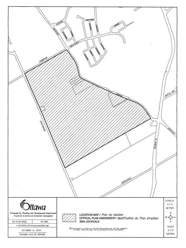
LOCATION PLAN Document
1
DRAFT
OFFICIAL PLAN AMENDMENT Document
2
AMENDMENT No. ____TO THE OFFICIAL PLAN FOR THE FORMER CITY OF NEPEAN AND AMENDMENT No. ____ TO THE COUNCIL ADOPTED OTTAWA OFFICIAL PLAN
INDEX
Components
Part A - The Preamble
Purpose
Location
Basis
Part B -
The Amendment
Introduction
Details
Amendment No. ____of the City of Nepean
Official Plan
Amendment No. ___ of the City Council
Adopted Official Plan
Implementation
Schedule “A” Land Use Jockvale Golf Community
(Area 13)
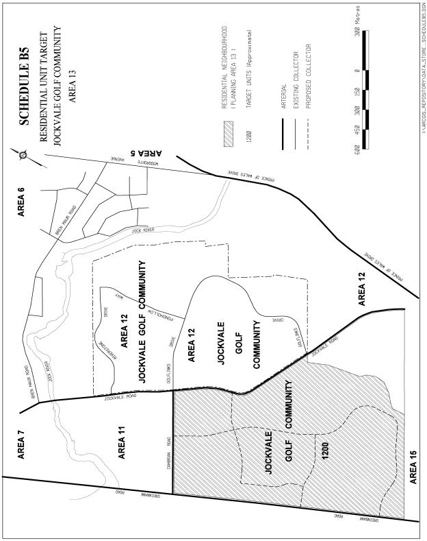
Schedule “B” Residential Unit Target Jockvale
Golf Community (Area 13)
COMPONENTS
PART A - THE PREAMBLE does not constitute part of this
amendment.
PART B - THE AMENDMENT, consisting of the following text and map (designated Schedules "A" and “B”) constitutes Amendments No.____and ___ to the Official Plans of the former City of Nepean and City of Ottawa respectively.
PART A - THE PREAMBLE
PURPOSE:
The purpose of amendments ___ and ___ are to
permit the extension of residential development by Monarch Construction in the
Jockvale Golf Community in the South Urban Area of the former City of Nepean. The amendment adds the attached text and schedules to the Nepean
Official Plan Secondary Plan and the Council Adopted Official Plan: Volume 2-A
Secondary Plan policies to create an
AREA 13 also known as the Jockvale Golf Community. This amendment updates the
Secondary Plans to add reference to these lands and provide a basis for
consideration of future phases of the development as it expands west of
Jockvale and south of Cambrian Roads.
LOCATION
The lands
affected by this amendment are located on the west side of Jockvale Road and
south of Cambrian Road in the South
Urban Community.
BASIS
Monarch Construction has registered and developed a number of subdivision plans in the South Urban Community of the former City of Nepean, in an area now referred to as the Jockvale Golf Community within the existing General Urban Area east of Jockvale Road. The final phases of development within the latter designation have been designed and approved and are under construction.
Under consideration now is an amendment to the Nepean Official Plan and the Council Adopted Official Plan: Volume 2-A to add a Secondary Plan for the balance of these lands located on the west side of Jockvale Road. This Secondary Plan will apply to an area to be known as Area 13. The Secondary Plan for Area 13 will update the relevant Official Plans, through this amendment, by creating land use designations and dwelling unit targets to incorporate this parcel of land into the Stonebridge Golf Community.
This amendment is consistent with the comprehensive planning objectives for development of the Stonebridge Community as articulated in the former Nepean Official Plan.
PART B - THE AMENDMENT
1. Introduction
All of this part of the document entitled Part B - The Amendment, consisting of the following text and attached maps designated as Schedules “A” and “B” constitutes Amendment No.___and Amendment No.__ to the former City of Nepean Official Plan and Council Adopted Official Plan respectively.
2. Details
AMENDMENT No. ___
TO THE CITY OF NEPEAN OFFICIAL PLAN AND AMENDMENT No ____TO THE CITY OF OTTAWA
OFFICIAL PLAN
That the Nepean Official Plan and the City Council Adopted Official Plan Volume 2-A Secondary Plans, is hereby amended as follows:
· the following text and schedules are added to the above-noted Official Plans
SECONDARY
PLAN
JOCKVALE GOLF COMMUNITY (Area 13)
1.0
DEVELOPMENT POLICIES
Area 13 is located west of Jockvale Road, south of Cambrian Road and
contains the westerly nine holes of the 18-hole golf course community to be
constructed on a 700-acre land holding.
In combination with part of Area 12, Area 13 is predominantly a planned
residential community with a collector road system that is transit supportive. A large neighbourhood park and a planned
school/park facility at the southeast corner of Cambrian and Greenbank Roads
will provide active recreational amenities to the community.
1.1
Land Use Components
Schedule A is the Land Use
Plan for the Jockvale Golf Course Community (Area 13).
Its components are:
i)
The Golf Course
This subdivision will contain the remaining nine holes to complete the 18-hole golf course winding through the residential community.
ii)
Residential
Will consist of one category:
1. Low/Medium Density (i.e. Low Density up to 16 uph net, comprising single detached dwellings and Medium Density up to 35 uph net, comprising ground oriented townhouses or “golf villas”) arranged in clusters. Medium Density development will generally have direct access to collector roads.
iii) Parks
Parkland will be provided on the basis of a minimum of 0.8 ha/1,000 persons for neighbourhood facilities and a minimum of 0.4/ha/1,000 persons for community park space.
Parks will be strategically located with respect to access and land suitability.
The sites will be of sufficient size to accommodate active recreational playing fields.
iv) Institutional
Provision has been made for a school/park facility at the southeast
corner of Cambrian and Greenbank Roads. Should the identified school site not
be required for the development of a school, the Low/Medium Density residential
designation shall apply without the need for an amendment to this plan.
1.2
Population
Area 13 has been designed to
accommodate approximately 1200 dwelling units at build-out.
Based on the expected age profile of the residents in Area 13, a relatively low average household size of 2.5 – 2.7 ppu is anticipated. At build-out, Area 13 is expected to provide living accommodation to some 3,000 to 3,240 people.
1.3
Transportation
Schedule A shows the major circulation system planned for the community. The locations shown for collector roads are approximate only and subject to adjustment as part of the detailed subdivision design. Emphasis will be placed on facilitating pedestrian, cyclist and transit movement through the golf course community. The transportation system will also provide for ease of pedestrian and cyclist access to complementary institutional facilities.
i)
Roads
The proposed collector and arterial road system providing access to the community is consistent with the recommendations of previous studies, including the South Nepean Urban Area Master Transportation Study (1977). Provision for realignment and widening of Jockvale Road and widening of Greenbank and Cambrian Roads will be made within abutting plans of subdivision, severances and site plans.
Local streets will be organized to provide direct access to the collectors. The road system will be designed so as to maximize vistas toward the golf course.
ii) Public Transit
The community will be served by bus transit, connecting to the extended transitway servicing South Nepean. The internal collector system has been arranged to permit the spacing of transit stops within 400 metres walking distance of all parts of the community.
iii) Pedestrian Movement
An on-street sidewalk system will be provided that consists of sidewalks on both sides of collector streets and on one side of most local roads as warranted, given the number of dwelling units accessed by the local road and the length of the particular road. The sidewalk system will be transit and pedestrian supportive. Cart paths along the golf course fairways will not be part of the public walkway system.
1.4 Services and Stormwater
Management and Utilities
Internal and external servicing constraints for Secondary Plan Area 13 have been identified. The following reports were used in the review:
- RMOC Water Master Plan 1977
- RMOC Wastewater Master Plan 1997
- South Nepean Urban Area Master Servicing Study (J.L. Richards)
- South Barrhaven Serviceability Study, 1993 (Cumming Cockburn Ltd.)
- South Nepean Phase III Lands, Master Drainage Plan, 1997 (CH2M Hill Gore & Storrie)
- Jockvale Servicing Study, 1999 (Cumming Cockburn Ltd. and CH2M Hill Gore & Storrie)
The 1999 Jockvale Servicing Study, referred to above, illustrates the proposed system of trunk storm and sanitary sewers to serve the area, as well as the proposed water distribution plan for the area. With the exception of the most westerly part of Area 13 paralleling the Greenbank Road, (the storm drainage from which will outlet into a new stormwater facility to be constructed in the vicinity of the intersection of Greenbank with the Jock River), the storm and sanitary sewer trunks and the feeder watermain providing service to Area 13 are located on the Jockvale Road. Similarly, hydro, gas, telephone and cablevision services to extended into Area 13 are located on the Jockvale Road.
1.5 Environmental Protection Measures
Requirements
of all levels of government for environmentally responsible construction as
manifested in the subdivision and site plan control approval processes will be
followed to adequately protect and enhance the features on-site.
1.6 Urban Design Policies
When considering Zoning By-law amendments and site plans, Council shall consider the following guidelines:
1. Integration of different housing types will be encouraged to foster community development. Long rows of townhouses should be avoided in order to encourage diversity in the built-form;
2. A variety of streetscapes throughout the community should be created in order to foster a sense of identity, especially at the entrances to the community and at highly visible locations along collector roads;
3. The provision of adequate on-street parking by examining street layout and mix of unit types;
4. Housing designs should minimize the projection of garages beyond the main front wall of the dwelling entry features should be afforded prominence and double driveways across the curb should be discouraged in order to reduce the dominance of automobiles on the streetscape;
5. Collector roads shall be designed to discourage cut-through traffic but at the same time provide for efficient movement through the entire community and various phases of development. They shall be aligned to afford vistas of the golf course, open spaces and parks, and environmental features that are to be preserved;
6. Neighbourhood service streets, which shall be designed to function as local streets, should be arranged to maximize vistas towards the golf course and prominent natural features, while providing pedestrian connectivity to the community facilities.
1.7
Phasing of Development
Development within Area 13 will be initiated at a collector road entrance off Jockvale, south of Cambrian at the site of both the trunk sanitary and trunk storm outlets for the area. Construction will proceed from north to south, first in the eastern portion of the site and secondly, when the Greenbank Road stormwater facility is completed from north to south in the westerly portion of the site.
2.0 IMPLEMENTATION
The implementation of this Amendment to the Official Plan documents shall be in accordance with the respective policies of the Official Plan of the former City of Nepean and City Council Adopted Official Plan.
SCHEDULE “A” LAND USE JOCKVALE GOLF COMMUNITY (AREA 13) 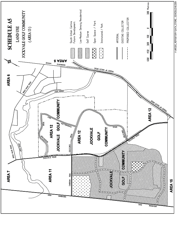
SCHEDULE
B: RESIDENTIAL UNIT TARGET JOCKVALE GOLF COMMUNITY AREA 13