3. COMMUNITY
DESIGN PLAN, OFFICIAL PLAN AMENDMENTS AND ZONING AMENDMENT FOR UPTOWN RIDEAU
(Rideau Street between King Edward Avenue and the Rideau River) PLAN DE CONCEPTION COMMUNAUTAIRE,
MODIFICATIONS DES PLANS officiel ET MODIFICATION DE ZONAGE DE LA RUE RIDEAU
EST (LA RUE RIDEAU ENTRE L'AVENUE KING EDWARD ET LA RIVIÈRE RIDEAU)
|
COMMITTEE RECOMMENDATIONS AS AMENDED
That Council:
1. Approve the Uptown Rideau Community
Design Plan as detailed in Document 7 with the following change:
Replace Figure 12 in
Document 7 with Figure 12a as contained in Document 8.
2. Approve the changes to Section 8.0
Appendix - Sandy Hill as contained in Volume III to the Official Plan for the
former City of Ottawa, as detailed in Document 2, subject to the following
amendment:
That the following change be made in Number 3:
That the word “east” be changed to
“west” and the word “west” be changed to “east” in the paragraph under the
section entitled “Mainstreet Mixed Use”.
3. Approve the modifications to the Sandy
Hill Secondary Plan as contained in Volume II to the Official Plan for the
former City of Ottawa, as detailed in Document 3.
4. Approve the modifications to the Sandy
Hill Secondary Plan as contained in Volume 2A to the Official Plan (2003) of
the City of Ottawa as detailed in Document 3.
5.
Approve the amendments to the former City of Ottawa Zoning By-law,
as detailed in Document 4, for the area shown in Document 5.
And that no further notice be provided pursuant to Section 34(17) of
the Planning Act.
RECOMMANDATIONS modifiées du COMITÉ
Que le Conseil :
1. approuve le Plan de
conception communautaire de la rue Rideau Est tel qu'il est détaillé dans le
Document 7 avec les modifications suivantes :
remplacer la Figure 12 par la Figure 12a telle qu’elle apparaît dans le
Document 8.
2. approuve les modifications à la section
8 de l’Annexe - Côte-de-Sable, telle qu’elle apparaît dans le Volume III du
Plan officiel de l'ancienne Ville d'Ottawa, telles qu’elles sont détaillées
dans le Document 2, sous réserve des modifications
suivantes :
Que la modification
suivante soit apportée au Document 2, numéro 3 :
Que le mot « est » soit remplacé par le mot
« ouest » et que le mot « ouest » soit remplacé par le mot
« est » dans le paragraphe figurant sous la rubrique « Rue
principale – Utilisation polyvalente ».
3. approuve les
modifications au Plan secondaire de la Côte-de-Sable, tel qu’il apparaît dans
le Volume II du Plan officiel de l'ancienne Ville d'Ottawa, telles qu’elles
sont détaillées dans le Document 3.
4. approuve les
modifications au Plan secondaire de la Côte-de-Sable, tel qu’il apparaît dans
le Volume 2A du Plan officiel de la Ville d'Ottawa (2003), telles qu’elles sont
détaillées dans le Document 3.
5. approuve
les modifications apportées au Règlement municipal sur le zonage de l'ancienne
Ville d'Ottawa, telles qu’elles sont détaillées dans le Document 4 pour le
secteur indiqué dans le Document 5, sous réserve des modifications ci-après
:
Et qu’aucun autre
avis ne soit donné aux termes du paragraphe 34 (17) de la Loi sur l’aménagement du territoire.
Documentation
1. Deputy City Manager, Planning and
Growth Management report dated 23 November 2004
(ACS2004-DEV-POL-0046).
2.
Extract of Draft
Minutes, 14 December 2004.
Report to/Rapport au :
Planning and Environment
Committee
Comité de l'urbanisme et de
l'environnement
and Council / et au Conseil
23 November 2004 / le 23 novembre 2004
Submitted by/Soumis par : Ned
Lathrop, Deputy City Manager / Directeur municipal adjoint
Planning and Growth Management / Urbanisme et Gestion de la croissance
Contact Person/Personne
ressource : Richard Kilstrom, Manager
Planning, Environment and Infrastructure
Policy/Politique d'urbanisme, d'environnement et d'infrastructure
(613) 580-2424 x13850, Richard.Kilstrom@ottawa.ca
REPORT RECOMMENDATION
That the Planning and Environment
Committee recommend Council:
1. Approve
the Uptown Rideau Community Design Plan as detailed in Document 7 with the
following change:
Replace
Figure 12 in Document 7 with Figure 12a as contained in Document 8.
2. Approve
the changes to Section 8.0 Appendix - Sandy Hill as contained in Volume III to
the Official Plan for the former City of Ottawa, as detailed in Document 2.
3. Approve
the modifications to the Sandy Hill Secondary Plan as contained in Volume II to
the Official Plan for the former City of Ottawa, as detailed in Document 3.
4. Approve
the modifications to the Sandy Hill Secondary Plan as contained in Volume 2A to
the Official Plan (2003) of the City of Ottawa as detailed in Document 3.
5. Approve
the amendments to the former City of Ottawa Zoning By-law, as detailed in
Document 4, for the area shown in Document 5.
RECOMMANDATION DU RAPPORT
Que le Comité de l'urbanisme et de
l'environnement recommande au Conseil :
1. d'approuver
le Plan de conception communautaire de la rue Rideau Est tel qu'il est détaillé
dans le Document 7 avec les modifications suivantes :
remplacer la Figure 12 par la Figure 12a
telle qu’elle apparaît dans le Document 8.
2. d'approuver
les modifications à la section 8 de l’Annexe - Côte-de-Sable, telle qu’elle
apparaît dans le Volume III du Plan officiel de l'ancienne Ville d'Ottawa,
telles qu’elles sont détaillées dans le Document 2.
3. d'approuver
les modifications au Plan secondaire de la Côte-de-Sable, tel qu’il apparaît
dans le Volume II du Plan officiel de l'ancienne Ville d'Ottawa, telles
qu’elles sont détaillées dans le Document 3.
4. d'approuver
les modifications au Plan secondaire de la Côte-de-Sable, tel qu’il apparaît
dans le Volume 2A du Plan officiel de la Ville d'Ottawa (2003), telles qu’elles
sont détaillées dans le Document 3.
5. d'approuver
les modifications apportées au Règlement municipal sur le zonage de l'ancienne
Ville d'Ottawa, telles qu’elles sont détaillées dans le Document 4 pour le
secteur indiqué dans le Document 5.
EXECUTIVE SUMMARY
Assumptions
and Analysis:
The recommendations contained in this report are:
a) to adopt the Uptown Rideau Community Design Plan with staff modifications related to building height as proposed in the Plan;
b) to approve the amendments to the Official Plan Appendix to reflect the new vision for the street as a Mainstreet and the proposed heights for the residential portions of the street;
c) to approve the amendments to the Sandy Hill Secondary Plan to reflect the new vision for the street as a Mainstreet; and
d) to approve the amendments to the Zoning By-law with modifications to implement the land use and built form directions of the Community Design Plan.
The Official Plan policies state that mainstreets are “important
areas for the preparation of community design plans…[which]…will be approved by
City Council and implemented through the zoning by-law and design guidelines.”
The Official Plan states that community design plans will identify:
· The boundaries of
the mainstreet designation;
· The nature and type
of uses that should be permitted;
· Area specific
design guidelines and requirements related to access and parking;
· Methods of
achieving good design;
· Opportunities to
design attractive corners and gateways;
· Appropriate
massing, scale, height and siting of buildings;
· Appropriate scale
transitions to adjacent areas;
· Locations suited to
being nodes of activity or landmarks; and
· Streetscape
improvements to make the area attractive to residents and businesses.
The recommendations contained in the report are consistent with the policies contained in both the former and new Official Plan.
Financial
Implications:
The Community Design Plan anticipates a substantial Capital investment by the City at a later date towards the beautification the street and the removal of hydro poles.
Public
Consultation/Input:
The Uptown Rideau Community Design Plan is a community initiative that has involved landowners, business people and local residents. There has been extensive public involvement in the process and there is broad public support for the Plan as submitted. Building height has been an issue throughout the process and remains an issue for some. Most of the surrounding community supports the heights as submitted with some wanting lower height and others wanting higher building heights. Localized increases to building heights are proposed by staff based on the policy directions contained in the new Official Plan.
RÉSUMÉ
HYPOTHÈSES ET ANALYSE :
Les recommandations du présent rapport sont :
1. d'adopter le Plan de conception communautaire de la rue
Rideau Est avec les modifications du personnel de la Ville en ce qui a trait à
la hauteur des édifices telle que proposée dans le Plan;
2. d’approuver les modifications à l'Annexe du Plan officiel
afin de refléter la nouvelle vision pour la rue en tant que rue principale et
les hauteurs proposées en ce qui concerne les parties résidentielles de la rue;
3. d'approuver les modifications au Plan secondaire de la
Côte-de-sable afin de refléter la nouvelle vision pour la rue en tant que rue
principale;
4. d'approuver les modifications apportées au Règlement
municipal sur le zonage avec les changements afin de mettre en vigueur les
directives du Plan de conception communautaire touchant l'utilisation des sols
et la forme des édifices.
Les politiques du Plan officiel stipulent que
les rues principales « constituent des secteurs prioritaires dans le cadre
de l'établissement des plans de conception communautaire… [qui]…seront adoptés
par le Conseil municipal et seront mis en vigueur en utilisant le règlement de
zonage et les lignes directrices de conception. » Le Plan officiel indique
que les plans de conception communautaire détermineront :
· les
limites exactes de l'aire désignée en tant que rue principale;
· la
nature et le type des utilisations qui devraient être permises;
· les
lignes directrices particulières pour le secteur et les exigences en ce qui a
trait à l'accès et au
stationnement;
· les
méthodes permettant d'obtenir une bonne conception;
· les
possibilités de conception de coins de rues et de voies ayant un aspect agréable;
· la
masse, l'échelle, la hauteur et l'orientation appropriées des édifices;
· les
transitions d'échelle appropriées aux secteurs avoisinants;
· les
emplacements convenables en vue d’établir un centre d'activité ou point central
de référence pour le secteur avoisinant; et
· des
améliorations au paysage de rue en vue de rendre le secteur plus attrayant aux résidents et aux entreprises.
Les recommandations formulées dans le présent
rapport sont conformes aux politiques de l’ancien et du nouveau Plan officiel
de la Ville.
RÉPERCUSSIONS FINANCIÈRES :
Le Plan de conception communautaire de la rue
Rideau Est prévoit des dépenses d’investissement substantielles de la Ville à
une date ultérieure visant l’embellissement de la rue et l'enlèvement des
poteaux électriques.
CONSULTATION PUBLIQUE/COMMENTAIRES :
Le Plan de conception communautaire de la rue Rideau Est est une initiative communautaire qui intéressait les propriétaires, les entreprises et les résidents locaux. De nombreux membres du public ont pris part au processus qui, en grande partie, appuient le Plan tel que soumis. La hauteur des édifices était un point de discussion durant le processus et le reste pour certains. La majorité de la communauté avoisinante appuie les hauteurs telles que soumises, certains membres préférant une plusfaible hauteur, d’autres une hauteru plus élevée. Le personnel de la Ville a proposé des augmentations localisées de la hauteur des édifices en se basant sur les directives de la politique du nouveau Plan officiel.
BACKGROUND
The Uptown Rideau Community Design Plan was prepared by the Rideau
Street Redevelopment Working Group (RSRWG). This group of local volunteers and
professionals was formed in 2001 in response to a growing dissatisfaction with
both the appearance and function of Rideau Street, between King Edward Avenue
and the Cummings Bridge. The RSRWG has collaborated with local businesses,
local residents and community organizations in the preparation of this Plan.
See Document 6 for details on the public consultation activities.
With the City's
commitment to various Official Plan directions for the development of
Mainstreets (a mix of uses, pedestrian orientation, design quality,
intensification, development compatibility and public improvement), there was a
need to find an appropriate set of urban design, zoning and land use measures
to apply these principles in detail. The Uptown Rideau Community Design Plan
and the Official Plan/Zoning amendments contained in this report, are the
result of this effort.
To firm up the
vision for the street, this Plan builds on the February 2000 Rideau Street
Design Charette, endorsed by the Ottawa Regional Society of Architects, and
sponsored by the Downtown Rideau BIA, the Ottawa Citizen, and various
professional groups and individual companies.
DISCUSSION
Recommendation
1 - The Uptown Rideau Community Design Plan
The Uptown Rideau Community Design Plan is a road map to the respectful transformation of Rideau Street into a successful and vibrant mainstreet. The Plan recognizes the existing conditions and a lack-of-identity along the street and that, with time, there is potential for Rideau Street to become one of Ottawa’s best mainstreets. The Plan lays out a vision based on this potential that is tailored to the Mainstreet directions as outlined in the new Official Plan and other RSRWG directions as summarized below:
a) Create a pedestrian-friendly street
that includes wide sidewalks, pedestrian lighting, street furniture, sidewalk
patio’s, trees/landscape improvements and pedestrian-focus areas;
b) Remove the hydro poles;
c) Use new buildings to establish a street
character based on: a consistent, human-scale height, architectural excellence,
building continuity and variety along the street;
d) Ensure that new buildings respect the
surrounding community through heritage conservation and neighbourhood
transition;
e) Permit mixed uses that serve the
surrounding neighbourhoods and encourage residential uses above the ground
floor;
f) Create a consistent pavement width (no
wider than necessary) to provide for integrated vehicular movement;
g) Encourage a light rail transit system that serves the local community; and
h) Develop two special projects, the
Cummings Island Bike Project and the McDonald Gardens Project.
All of the proposed changes presented in the Community Design Plan were crafted with good design in mind to achieve appropriate mainstreet, human-scale building faces, wide sidewalks, the infilling of unsightly gaps, lots of windows at street level and direct connections to the sidewalk. These all serve to affect the public realm in a positive way. To make well-designed, sustainable mainstreets where people want to live, guidance needs to be provided where all issues related to the quality of place, and the priority of the pedestrian, have been addressed. The object is to secure what is important in design while encouraging creativity and innovation in the architecture of buildings. The opportunity comes at the site plan approval process to work with proponents, ideally at the pre-consultation stage, to refine the urban design aspects, and to the extent possible, the architectural details through the review of the proposal.
Key Issues
Removing the Hydro Poles:
This was the number one priority for the Rideau Street Redevelopment Working Group (RSRWG) as a way to upgrade the street. It was considered as the most important element in the development of residential apartments above the ground floor of new buildings and the construction of wide pedestrian sidewalks that would function as the recreational spaces for residents along the street.
Staff agrees with the RSRWG that removing the hydro poles is an important part of revitalizing Rideau Street. Although it is recognized that removing the hydro poles is a costly proposition, the actual costs to bury the wires may be lower than anticipated due to the presence of existing underground infrastructure able to accommodate the wires.
Light Rail
The inclusion of future rail transit along Rideau Street in the Transportation Master Plan occurred half way through the preparation of the Uptown Rideau Community Design Plan. The light rail concept has been referred to in the Community Design Plan because the Community Design Plan is viewed as a comprehensive design-led document and because the implementation of light rail was seen as a way to accelerate improvements to the street.
It was clear from the October 12, 2004 community meeting that the previous draft of the Community Design Plan did not reflect the views of the public nor the Rideau Street Redevelopment Working Group. There were strong opinions expressed that the light rail system should function like a streetcar and make many stops along Rideau Street. The new Plan, as contained in Document 7, reflects these opinions as suggestions for the future, starting in Section 4.4.16. Although staff do not necessarily agree with all of these suggestions, some may be useful criteria in the evaluation of future light rail options.
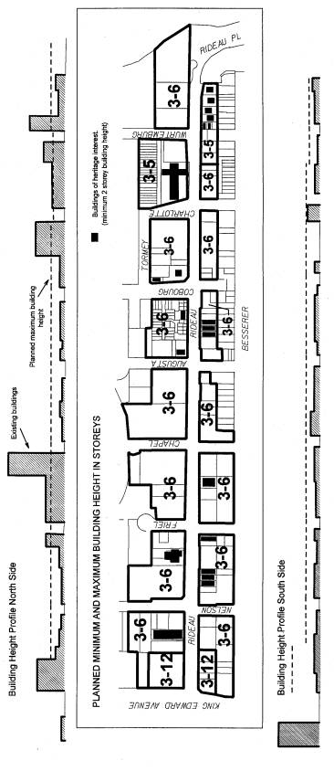
Building Height
The RSRWG felt that the existing direction for building height contained in the Official Plan of the former City of Ottawa, including the Sandy Hill Secondary Plan, is no longer appropriate for Rideau Street because:
a) The existing built form on the north
side of the street is inconsistent and many buildings are not at a scale that
is friendly to the pedestrian;
b) The "Major Commercial"
designation on the south side of the street is an outdated designation,
introduced in the 1970's when uses were separated, and streets like Rideau were
considered as edges to residential communities where all the non-residential
uses, not suited to the community, should go; and
c) The two different approaches to
planning the north versus the south side of the street do not help in efforts
to develop a consistent human-scale character as described in the new Community
Design Plan.
In the Official Plan for the former City of Ottawa, this portion of Rideau Street is designated as a "Neighbourhood Linear Commercial Area", where development is intended to be at a pedestrian scale. On the north side, specific built-form provisions in the Official Plan guide developments to take their cues from existing surrounding heights that range from one to 22 storeys. The land on the south side of Rideau Street, which is part of the Sandy Hill Secondary Plan, is designated as "Major Commercial" in that Plan from King Edward Avenue to Wurtemburg Street, and as "Medium Profile Residential" from Wurtemburg to the Cummings Bridge. For "Major Commercial" the maximum established heights are up to 12 storeys and for "Medium Profile Residential", up to 6 storeys (based on information contained in the Appendix to the Official Plan).
The RSRWG settled on mid-rise building heights as part of an overall strategy to revitalize the street. The mid-rise buildings were intended to provide an interesting and active foreground to a vibrant, pedestrian-friendly street; and, to put some of the existing, out-of-scale buildings in the visual background. The explored options included permitting eight storeys instead of six along the street and permitting eight or more storeys at nodes and at gateway sites. The RSRWG eventually concluded that buildings higher than six storeys risked the pedestrian-friendly nature as planned, however the desire for consistency did not preclude variable heights based on good architecture, but still at a human-scale.
From staff's perspective, the focus on built form should be on the quality of the first few storeys and on making sure they are well designed, detailed and interesting and that they relate to the pedestrian on the sidewalk and to the surrounding environment. The Community Design Plan as proposed says all the right things about the street environment, except to say that the focus or interest may extend beyond the ground floor to also include the first few floors above. What is above the first few floors, from a design point of view, however, is felt by staff to be less influential to the image and vitality of the street.
In order to implement intensification, Official Plan policies direct that higher heights along a Mainstreet should be identified at nodes and at landmark locations that are able to accommodate more residents. The Official Plan also states that Community Design Plans are one of the principal planning documents to identify places with potential for intensification. Rideau Street, being a designated Mainstreet and located close to Downtown, is clearly a street that provides such opportunities.
That being said, it is recognized that there are limits of acceptability to building height and that the public and the surrounding community is most interested in identifying those limits.
Within this context, the following recommendations and observations are made:
1. The Southeast Corner of King Edward and Rideau Street
The intersection of King Edward Avenue and Rideau Street is recognized as a node of activity that should be considered for further intensification mainly because of its location at the crossroads of these two important and wide streets. There are already two buildings at the intersection that are higher (18 and 12 storeys) than the planned heights as proposed in the Community Design Plan. It is recommended that the maximum building height for the corner parcels of land on the south side of the street be increased to 12 storeys as shown in Figure 12a in Document 8, to match the height of the Confederation Building on the north side of the street. While affecting the Plan, adding a higher building at the third corner does not compromise its qualitative aspects. Being on the edge of the Uptown Rideau area, there is sufficient land to accommodate a building that, at one end, is compatible with the King Edward node and, at the other end, has stepped down to the surrounding planned heights.
It is further suggested that an added two-metre building setback be established after the 6th storey along Rideau Street for all buildings that are higher than six storeys. This would ensure that the mid-rise portion of the building reflects the same patterns as are proposed along the rest of Rideau Street.
2. The Northeast Corner of King Edward and Rideau Street
Further to the above, the Confederation Building at the northeast corner of King Edward and Rideau Street is also at the King Edward node and the property has a zoning height limit of 37 metres that is equivalent to 12 storeys. It is therefore recommended that the existing height of the Confederation Building be recognized in the Plan.
3. The Southeast Corner of Charlotte and Rideau Street
The parcels of land at the southeast corner of Charlotte and Rideau Street (582-592 Rideau) have an existing building height of 18 m in the Zoning By-law, equivalent to 6-storeys. An offer to purchase has recently been received to develop most of these parcels based on the existing zoning provisions and a representative of the Owner has discussed a proposed development with staff. It is therefore recommended that the building height be increased for these properties from the five storeys proposed in the CDP to six since the added storey is a minor change to the planned height and will permit the existing zoning height to remain.
It is recommended that the Uptown Rideau Community Design Plan be approved and that Figure 12 be replaced by Figure 12a as contained in Document 8, which modifies the building heights as described above.
Recommendation 2 -
Changes to the Appendix of the Official Plan for the former City of Ottawa
Although the Appendix of the Official Plan for the former City of Ottawa is not considered part of the Official Plan, the information contained in it has been used as background in the review of development applications. Two changes are proposed to bring the Appendix up-to-date and to eliminate potential conflicts with the provisions of the Uptown Rideau Community Design Plan. It should be noted that the Official Plan (2003) of the City of Ottawa does not contain such an Appendix.
First, a new Mainstreet Mixed Use designation will be added and described in general terms to reflect the directions contained in the Uptown Rideau Community Design Plan. Second, in relation to the Medium Profile Residential Area, the building height limit of 60’ should be changed to 50’, for the properties east of 592 Rideau Street, to reflect the Plan's desired maximum building height of 5-storeys.
It is recommended that the changes to the Appendix to the Sandy Hill Secondary Plan be approved as contained in Document 2.
Recommendations 3 and 4
- Modifications to the Official Plans - Sandy Hill Secondary Plan
To consider the Community Design Plan as the guiding land use document for the Uptown Rideau area, it is necessary to modify the commercial designation for the south side of Rideau Street as contained in the Sandy Hill Secondary Plan. The "Major Commercial" designation in the Sandy Hill Secondary Plan applies between King Edward Avenue and Wurtemburg Street. It is a designation that is inconsistent with the land use and built form provisions in the Uptown Rideau Community Design Plan. A new "Mainstreet Mixed Use" designation is proposed for the area.
Otherwise, the Community Design Plan conforms to Volume 1 of the new Official Plan and to the “Primary” Official Plan for the former City of Ottawa. The new Plan designates this portion of Rideau Street as a "Mainstreet" and the former Plan designates it as a "Neighbourhood Linear Commercial Area".
It is recommended that the changes to the Sandy Hill Secondary Plan in the new and former Official Plans for the City of Ottawa be approved as contained in Document 3.
Recommendation 5 –
Modifications to the Zoning By-law
The following zoning changes for the area shown in Document 5, as detailed in Document 4, are recommended for approval to provide a consistent CN Zone for the Uptown Rideau area and to implement many of the built form and design provisions of the Community Design Plan, including those discussed in Recommendation 1:
a) A new Neighbourhood Commercial (CN) Zone is proposed for both sides of the street;
b) Minor changes to the list of permitted
land uses at-grade are proposed to promote greater compatibility with the
surrounding street (more vibrant and commercial along Rideau Street and more
residential along the other streets) and above-grade, to encourage more
residential by requiring half of the floor space for larger projects to contain
residential space;
c) Built form and building façade
provisions are proposed to implement good design including: direct pedestrian
links between buildings and the sidewalk; a requirement that 50% of front
facades be windows and doors; a higher ceiling height for the ground floor than
the floors above; a 1 metre setback, where required, to provide space for a
widened sidewalk; and a maximum building setback of 2 metres to ensure new
buildings are built close to the street;
d) Minor increase in height from 18 to 19
m to provide ground floor elevations that are higher than the floors above;
e) A neighbourhood transition building
setback of 3 metres is proposed after three or four floors where the building
abuts a low profile residential neighbourhood;
f) A minimum building height equivalent to three storeys is proposed;
g) On three properties, building heights are increased to 19 metres;
h) Building heights are increased from 18
metres to 37 metres at the southeast corner of the King Edward node;
i) For Rideau Street properties higher
than 6 storeys, an added 2 metre building setback shall be applied above 6
storeys.
j) On the south side of Rideau Street
east of 594 Rideau Street, building heights are decreased to 16 metres to
reflect the narrower right-of-way of Rideau Street;
k) The property on the north side of
Rideau Street, east of Wurtemburg Street (including 215 Wurtemburg Street and
641-655 Rideau Street) is to be rezoned from Residential to Neighbourhood
Commercial with an apartment continuing to be a permitted use.
The various floor space index (FSI) standards that currently apply
along Rideau Street reflect an alternate and often different standard of
development than the maximum building heights would allow. This dual control
mechanism, whereby both building height and floor space index are controlled
through zoning, has the effect of reducing building heights if the floor space
index is greater than what can realistically be built at six storeys; or
conversely, allows buildings up to six storeys but with more space around the
building as the floor plate is reduced. It is proposed that FSI control
continue, but that the standards be brought closer to the building height
standards based on what can realistically and typically be built along the
street. It is therefore suggested that the proposed floor space index (FSI)
standards be generally increased as follows: to 3.5 for the properties, a) on
the north side of Rideau Street, and b) on the south side from King Edward
Avenue to Chapel Street; to 3.0 on the south side between Chapel and Charlotte
Street (because the depth of the CN Zone is less than the depth where the 3.5
applies); and to 2.5 on the south side of Rideau Street from 596 Rideau Street
(just east of the former Cajan Attic property) to the Cummings Bridge (because
the desired building height is less than the other areas). These new numbers
are reflected in Document 4. Site specific FSI standards that are higher than
the proposed standards, will not be changed.
ENVIRONMENTAL IMPLICATIONS
The recommendations contained in this report support the strategy of intensification contained within the new Official Plan, that have environmental implications relative to a more efficient use of land already serviced by existing infrastructure. This translates to more intense building forms replacing vacant and under-built sites within the City, taking advantage of existing amenities and services.
CONSULTATION
A summary of the public notification and consultation, including the comments received, are detailed in the attached Document 6.
FINANCIAL
IMPLICATIONS
The Community Design Plan anticipates a
substantial Capital investment by the City at a later date towards the
beautification of the street and the removal of hydro poles.
SUPPORTING DOCUMENTATION
Document 2 Changes to the Appendix of the Official Plan for the Former
City of Ottawa
Document 3 Official Plan Amendments
Document 4 Zoning Amendments
Document 5 Zoning Map
Document 6 Consultation Details
Document 7 Uptown Rideau Community Design Plan (English and French copies
on file with City Clerk and distributed separately)
Document 8 Revised Figure 12a
DISPOSITION
Corporate Services Department, Legal Services Branch,
to forward implementing by-laws to City Council.
Planning and Growth Management Department, Planning and
Infrastructure Approvals Branch to:
1. prepare implementing
Official Plan and Zoning By-laws;
2. notify persons who made oral or written submissions at the Planning and Environemnt Committee meeting and all persons and public bodies who requested to be notified of the adoption of the Official Plan Amendment and the passage of the Zoning By-law; and to advertise the passage of the Zoning By-law Amendment.
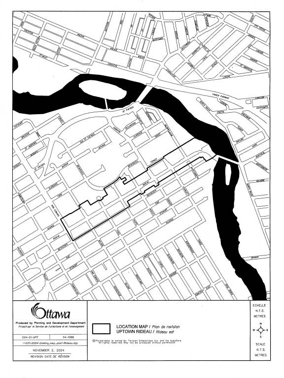
LOCATION MAP Document
1
CHANGES
TO OFFICIAL PLAN Appendix Document 2
PROPOSED CHANGE
TO APPENDIX - SECTION 8.0, TO THE OFFICIAL PLAN FOR THE FORMER CITY OF OTTAWA
1. After the sub-heading
“Categories of Residential Land Use”, on page 2, under Residential Land Uses,
in a), add the following as the last paragraph under “ii) Medium Profile”:
“For the Medium
Profile Residential Area designation that abuts Rideau Street, a 50’ height
limit applies for the properties east of 594 Rideau Street.”
2. On page 5, under
Commercial Land Use, in b) Major Commercial, remove the first two paragraphs.
3. On page 4, immediately before
Institutional Land Use, add the following section:
“Mainstreet Mixed Use
This area is the
southern side of the Uptown Rideau mainstreet that extends from King Edward
Avenue in the east, to the Cummings Bridge in the west. It serves Sandy Hill,
Lowertown East and a larger market area. It is intended that Uptown Rideau be
transformed into a vibrant and charming community mainstreet based on mid-rise
buildings, a mix of uses, pedestrian-friendly sidewalks, high quality
architecture, a fully integrated roadway for transit, pedestrians, cyclists and
motorists, and a transition strategy to blend the built form along the
mainstreet with the surrounding lower profile neighbourhoods.”
Official Plan
AMENDMENTS Document
3
1. OFFICIAL
PLAN AMENDMENT NO. ___ TO THE OFFICIAL PLAN FOR THE FORMER CITY OF OTTAWA.
2. OFFICIAL PLAN AMENDMENT NO. ___ TO THE
OFFICIAL PLAN (2003) OF THE CITY OF OTTAWA.
INDEX
Page
THE STATEMENT
OF COMPONENTS i)
PART A - THE
PREAMBLE
1.0 Purpose 1
2.0 Location 1
3.0 Basis 1
PART B - THE
AMENDMENT
1.0
Introduction 2
2.0 Details 2
3.0
Implementation 3
THE STATEMENT
OF COMPONENTS
Part A - The
Preamble introduces but does not constitue part of these Amendments.
Part
B - The Amendments, consisting of text and the attached map (designated
Schedule "A"), constitute individual amendments to the listed
Official Plans below:
Amendment No. ___ to the Official
Plan for the former City of Ottawa
Amendment No. ___ to the Official
Plan (2003) of the City of Ottawa.
PART A - THE
PREAMBLE
1.0 Purpose
The purpose of this
Amendment is to adopt a new policy framework for the south side of Rideau
Street that is consistent with the framework as established in the Uptown
Rideau Community Design Plan. The modifications in this Amendment are intended
to establish an overall context for Rideau Street by incorporating a new
Mainstreet Mixed Use designation into policy. It will also be providing the
necessary policy support for the implementation of development and public
initiatives to improve the physical environment of Rideau Street; and
introducing transition policies designed to enhance the relationship between
Rideau Street and the surrounding residential community. The proposed
modifications apply only to the Sandy Hill Secondary Plan.
2.0 Location
The lands affected by
this Amendment generally front on the south side of Rideau Street between King
Edward Avenue and the Rideau River.
3.0 Basis
This Amendment is
consistent with the General Urban policies of the former Regional Official
Plan. The Neighbourhood Linear Commercial Area policies in the Official Plan of
the former City of Ottawa and the Mainstreet policies in the Official Plan
(2003) of the City of Ottawa support for the continued development of Rideau
Street as a mixed-use pedestrian-friendly street. The proposed amendments to
the Sandy Hill Secondary Plan, which is found in both the Official Plan for the
former City of Ottawa and the Official Plan (2003) of the City of Ottawa,
provide further planning guidance on Rideau Street. The Major Commercial
designation that applies to the main portion of the south side of Rideau Street
will be amended to a new Mainstreet Mixed Use designation with general policies
that reflect the community vision and the design planning principles as
detailed in the Uptown Rideau Community Design Plan.
PART B - THE
AMENDMENT
1.0 Introduction
All of this part of
this document entitled Part B - The Amendment, consisting of the following text
and the attached map designated Schedule "A", constitutes Amendment
No. ___ to the Official Plan of the former City of Ottawa and constitutes Amendment
No. ___ to the Official Plan (2003) of the City of Ottawa.
2.0 Details
The following changes
are hereby made both to:
i) Volume II of the
Official Plan of the former City of Ottawa; and
ii) Volume 2A of the
Official Plan (2003) of the City of Ottawa.
2.1 New Land Use Designation:
That Schedule
"J" - Sandy Hill Land Use in the Sandy Hill Secondary Plan is hereby
amended by deleting the "Major Commercial" designation as it applies
to the lands identified on Schedule "A" to this Amendment, and substituting
therefore the new designation "Mainstreet Mixed Use" designation, as
shown on Schedule "A" to this Amendment.
2.2 New General Policy
That Subsection
5.3.1.d) Policies - General of the Sandy Hill Secondary Plan is hereby amended
by deleting, "(e.g., the Rideau Street commercial district" and
replacing it with "(e.g., the mainstreet mixed uses area along Rideau
Street".
2.3 New Land
Use Category
That the following new
Subsection 5.3.2.e) - Mainstreet Mixed Use category is hereby added after Subsection
5.3.2.d) to the Sandy Hill Secondary Plan:
“5.3.2. e) Mainstreet Mixed-Uses
i) To transform Uptown Rideau into a vibrant
and charming community mainstreet.
ii) To permit mid-rise buildings and a mix of
land uses.
iii) To provide a
transition strategy between the mainstreet and the surrounding lower profile
neighbourhoods.
iv) To provide high
quality architecture, pedestrian-friendly sidewalks and a fully integrated
roadway for transit, pedestrians, cyclists and motorists.”
2.4 New Land Use Category added to Schedule J
That a new
"Mainstreet Mixed Use Areas" and a new colour associated with it be
added to the Legend in Schedule J to the Sandy Hill Secondary Plan.
3.0 Implementation
The implementation of
these Amendments shall be in accordance with the respective policies of the
Official Plan of the former City of Ottawa and the Official Plan (2003) of the
City of Ottawa.
SCHEDULE A
AMENDMENT TO THE OFFICIAL PLAN OF THE FORMER
CITY OF OTTAWA, Volume II (Sandy Hill Secondary Plan) and OFFICIAL PLAN (2003)
OF THE CITY OF OTTAWA, Volume 2A (Sandy Hill Secondary Plan).
Zoning AMENDMENTS Document
4
Details of the Proposed Zoning Changes
That a new CN
subzone be created to provide for the following modifications to the CN zone:
1. That the following permitted uses be
required to be located above the ground floor: a parking garage, a utility
installation, a shelter, where the first two would also be permitted below the
ground floor.
2. That the following shall be the only
permitted uses on the ground floor of a building that directly abuts
Beausoleil, Besserer and Tormey Streets: a dwelling unit, a retirement home, an
artist studio, and a bed and breakfast establishment. This shall be applied to
a minimum of the first 6 metres of building depth where the building directly
abuts one of the above streets.
3. That a parking lot and parking spaces
must be located at least 4.5 metres from a property line that abuts Beausoleil,
Besserer and Tormey Streets.
4. That 50 percent of the gross floor area
over 2,000 m2 must be used for the following residential uses where a
development exceeds 2,000 m2: dwelling units, retirement home, converted
retirement home, rooming house, converted rooming house, or special needs
house.
5. That an apartment building and a high
rise apartment building, with a maximum height of six storeys, and a townhouse
building be permitted on the properties between Charlotte Street and the Rideau
River and on the properties that abut Besserer, Beausoleil and Tormey
Streets. Despite the above, the maximum
height for a high rise apartment building shall be five storeys for 596-610
Rideau Street (south side).
6. For the purpose of determining the
front yard setback, a lot that abuts Rideau Street is to be treated as though
it fronts on Rideau Street.
7. That all ground floor uses abutting
Rideau Street provide a direct pedestrian access off Rideau Street.
8. That the ground floor building façade
abutting Rideau Street contain a minimum 50% windows and doors.
9. That the height of the ground floor be
a minimum one metre higher than the floors above it.
10. For properties that abut Rideau Street,
the front yard setback shall be:
a) a minimum one metre
between Augusta Street and Cummings Bridge;
b) no minimum between
King Edward Avenue and Augusta Street; and
c) a setback of 2 metres
shall be applied above 6-storeys that has the effect of stepping the upper floors further back from Rideau Street than the
lower floors.
11. For properties that do not abut Rideau
Street, the minimum front yard setback shall be 3 metres.
12. For properties that abut Rideau Street,
that the maximum front yard setback shall be two metres between Augusta Street
and Cummings Bridge; and one metre between King Edward Avenue and Augusta Street,
except for the accommodation of an outdoor patio located at the corner of a
corner lot, for which the maximum front yard setback may be 4 metres along the
frontage of a restaurant use only, for a length along the frontage that is no
greater than 6 metres. The maximum setback shall not apply after 3-storeys.
13. For properties that abut Rideau Street,
that the minimum corner side yard setback shall be 1.0 m and the maximum shall
be 4.0 m. except that a 3.0 metre minimum and a 6.0 metre maximum setback shall
be applied to the property at 292 Rideau Street.
14. That the minimum rear yard setback shall
be 7.5 metres where it abuts a rear yard in a residential zone except an R6
Zone; and 3 metres in all other cases.
15. That the maximum building height shall be
19 metres, except:
a) On the south side of
Rideau Street from 596 Rideau Street to Wurtemburg Street, where it shall be 16 metres;
b) At 303, 292, 306,
308, 312 and 314 Rideau Street, where it shall be 37 metres; and c) At 560 Rideau Street, where it
shall be according to the heights in Schedule 251.
16. For properties that abut a residential
zone other than an R6 Zone, an added 3 metre rear yard setback shall be
applied: above the fourth storey where the maximum building height is more than
16 metres; and above the third storey, where the maximum is 16 metres or less.
17. That the minimum building height shall be
10 metres except for the following properties that contain a building of
heritage interest where a minimum of 5 metres shall apply:
506 Rideau Street
508 Rideau Street
510 Rideau Street
541 Rideau Street
487 Rideau Street
377 Rideau Street
511 Rideau Street
589 Rideau Street
323 Rideau Street
362 Rideau Street
364 Rideau Street
366 Rideau Street
390 Rideau Street
418 Rideau Street
18. That the minimum width of a landscaped
area does not apply to the front yard abutting Rideau Street.
19. That subsection 299, relating to density
restrictions, shall not apply.
20. That the requirements of Sections 315 to
318, relating to amenity area, shall be included in the new CN subzone where
they currently apply for the properties on the south side of Rideau Street.
21. A driveway may be situated equally or in
part on two abutting properties that abut Rideau Street.
22. A parking area may have access to a
public street through another lot.
23. That a minimum driveway width be reduced
to 3 metres for parking lots with less than 20 spaces and 6 metres for parking
lots with 20 spaces or more.
24. For the properties currently zoned as
shown in the left column below, that the F ( ) suffix be changed as shown in
the right column:
BEFORE CHANGE AFTER CHANGE
CN F (2.5) F
(3.5)
CN F (3.0) F
(3.5)
CN F (4.25) F
(4.25)
CN F (5.0) F
(5.0)
CN [502] F (1.25) SCH.
42 F (3.5)
CN [536] F (1.75) SCH.
108 F (1.75)
CN [536] F (2.8) SCH.
108 F (3.5)
CN F (1.0) H (10.7) F (2.5)
CN3 F (3.0) F (3.5)
CN3 [584] F (3.0) H
(37.0) F (3.5)
CN7 F (2.0) F (3.5)
- west of Chapel Street
"
F
(3.0) - Chapel to Charlotte Street
" F
(2.5) - east of Charlotte Street
CN7 [522] F (1.52) H
(10.7) F (3.0)
CN7 [876] F (4.25) SCH.
251 F (4.25)
R6B [167] F (2.5) F (3.5)
25. That the requirements
contained in Exceptions 167, 502, 536, 584 and 876 shall continue to apply.
26. The requirements contained in items 9, 10
and 15 above shall not apply to the property on the south side of Rideau
Street, known municipally as 560 Rideau Street.
27. For the property at the southeast corner
of Rideau Street and Augusta Street, known municipally as 490 Rideau Street,
the requirements of Exception 522 shall continue to apply except for the
reference to a maximum 10.7 m building height which shall be removed.
28. The requirements contained in items 4, 9 and
12 shall not apply to the property at the northeast corner of Rideau Street and
King Edward Avenue, known municipally as 303 Rideau Street.
That the I1
Zone be modified as follows:
1. That the suffix “F (3.5) H (19.0) shall
be added to the I1 Zone at the northeast corner of Rideau Street and Chapel
Street, known municipally as 151 Chapel Street.
2. That the height of the ground floor be
one metre higher than the floors above it.
3. That the minimum building height shall
be 10 metres.
That the R6A Zone
be modified as follows:
1. That the suffix H (18.3) shall be
replaced by suffix H (16) for the properties on the south side of Rideau
Street, known municipally as 630–644 Rideau Street and 223, 225 and 227
Wurtemburg Street, subzone R6A [87] H (18.3).
2. That the height of the ground floor be
one metre higher than the floors above it.
3. That an added 3 metre rear yard setback shall be applied above the third storey.
ZONING MAP Document
5
Consultation
Details Document
6
Following a February, 2000 Design Charrette, a
group of interested people led by Lena Creedy, former Councillor Madelaine
Meilleur and Councillor Georges Bédard decided to form the Rideau Street
Redevelopment Working Group (RSRWG). Those invited to participate were:
merchants along Rideau Street, residents of the surrounding neighbourhoods,
design and planning professionals, City staff and various interest groups. The
Group held its first meeting in September 2001. At the subsequent meeting, the following
sub-groups were formed: Architecture (led by Rhys Phillips); Streetscaping and
Lighting (led by Donald Morse); Transportation (led by Jonathan Freedman) and
Education (led by Lena Creedy).
Between 2001
and 2004, the Group undertook the following forms of consultation and
notification:
Door-to-door
or phone notification to property owners/tenants along Rideau Street.
E-mail
notices to the Downtown Rideau BIA, the ByWard Market BIA, the King Edward Task
Force, developers/investors/architects, and to residents of Sandy Hill and
Lowertown East.
Displays at
various RSRWG meetings and at one meeting of the Ottawa Little Theatre.
Information
provided at Action Sandy Hill annual general meetings for 2002, 2003, 2004.
Uptown Rideau
Design Plan information available at various times on the following websites:
Action Sandy Hill; Councillor Georges Bédard; and the Rideau Branch Public
Library.
Various
articles and notices in “Image”, the Sandy Hill community newspaper.
The RSRWG
sponsored the following specific events:
1. Walking Tour along Rideau Street
Date: Fall, 2001
2. Saturday “Walk-on-Rideau” consultation
and RSRWG display boards located at the Rideau Loblaws
Date: Fall, 2002
3. Regular meetings of the RSRWG every
three months open to the public to discuss issues and the progress of the Plan.
4. Public Meeting to launch the draft
Uptown Rideau Design Plan
Date: Tuesday, October 7, 2003
Participation: 38
5. RSRWG Meeting on the draft Uptown
Rideau Design Plan
Date: February 17, 2004
Participants: 18
6. Community Meeting to present the final
draft Uptown Rideau Community Design Plan
Date: October 12, 2004
Participation: Approximately 30
Summary of
Comments received following the October 12, 2004 community meeting:
Multiple
responses:
The Plan and
its vision are good (5);
The light
rail system should serve the local community like a streetcar (4);
More flexible
building heights are needed (one said 9/12 storeys as a minimum, two said that
if it is necessary to specify a height, one preferred 8 storeys, the other 6
storeys) (3);
The 6-storey
building height as proposed is good (2);
Lower
building heights are needed (one said 3 storeys on the south side of Rideau
Street between Wurtemburg Street and the Cummings Bridge; the other said 4 storeys
on the north side of Rideau Street) (2); and
Detailed
zoning changes are needed (2).
Single
responses:
Problems with
the Capital City Mission;
Night time
safety is an issue;
Make McDonald
Garden Park a poop and scoop park;
Design
guidelines are needed;
Make Rideau
Street like Bank Street in the Glebe;
Improve the
Pizza Pizza site;
Keep traffic
flow moving; and
The vision is
fundamentally flawed. Sandy Hill has hijacked the process.
Action Sandy
Hill (ASH) Comments
Here are some
detailed suggestions for the zoning changes for Rideau Street.
a) different subzones for the North and
South sides of Rideau street might allow for small differences that come from
the Sandy Hill Secondary Plan.
b) Keep the indoor/outdoor amenity area
provisions from CN7. These come
directly from the Sandy Hill Secondary Plan.
The Volume 3 appendix specifies a minimum of 300 square feet of
recreation area per apartment unit.
c) Keep the 50% floor space residential
requirement above 20,000 square feet that is in the current CN7 subzone.
d) Where
is the front upper storey setback in the zoning?
e) Maximum front yard setback: There are all sorts of cases where this is
the best place to put some open space or patio or public art or where
compatibility with existing heritage buildings requires it. What happens when someone wants to renovate
one of the existing old houses? What
about the current practice of negotiated informal right-of-way widening without
a conveyance? I suggest we simply ban
some front yard uses such as parking, and let economics take care of minimizing
the front yard setback.
f) Can we put facade requirements on side
walls being treated as front walls when a heritage building next door has a
larger front setback in the zoning?
It’s a question; I don’t know if we can.
g) Parking requirements for lots retaining
buildings of heritage interest. We need
to more narrowly define “lot”, “retaining” and “heritage interest”. This is all done by using heritage overlays.
h) Where are the heritage overlays? Note: I spoke with Georges Bédard about
adding the missing heritage overlay for the Rideau Library, which is protected
under the Act. I assume there is one
currently in place for Wallis House.
i) Residential only in first 6 metres
abutting Tormey, Beausoleil, and Besserer.
Does this mean no surface parking?
Is this first 6 metres of the lot or of the building?
j) CN7[522] F(1.52) H(10.7) I presume
that there was a house there once and this was a deal to allow a
demolition. I agree we should respect
that deal.
k) Wallis House zoning. This was a deal
worked out with give and take to preserve the character of the lot and protect
the heritage building. Let’s respect
that deal on all the lots involved and keep it as is for height and density.
l) CN7[876] F(4.25) SCH.251. I see no
reason not to apply the height and setback provisions of the new CN subzone
here. The OMB decision on height was
based on OP provisions that are being amended.
Let’s make a consistent policy recommendation and let council worry about
the politics. In fairness, keep the
schedule with the amenity area and ground floor residential use changes; that
was an explicit decision by the OMB not to apply those OP provisions to this
lot.
m) R6A, R6B at the corner of Beausoleil and
Chapel Streets. I disagree with adding commercial uses. In fact, I think it should be zoned R5 and
12 metres high, not CN, in order to rehabilitate the street and the area around
the schools. The lots are too small to
be effective as CN and in any case with 6 metres residential abutting
Beausoleil, CN would be silly.
n) Keep the I1 zoning at Chapel
Street. We always oppose changes away
from I1 zoning. A certain amount of
institutional zoning is required in this part of town. Most such changes are irreversible and many
institutions like schools and day care centres are unable to find space near
where the demand is. Demand hasn’t gone
down and supply hasn’t gone up. The new
OP in my reading discourages such conversions in general, and I don’t think
council believes this should ever be done without a specific proposal. Keep the I1 zoning. Change the yards, but otherwise leave as is.
o) L3 zoning. Wouldn’t now be a good time
to remove the [87] from this zoning?
Why would we put an embassy in the park?
p) ASH wants to keep FSI in the
zoning. This allows the possibility of
more sensible infill since the value of smaller lots of land is less affected
by land assembly, demolition of heritage houses and large-scale projects. The figures below are based on what can be
achieved with intermediate-sized lots that conform to the plan, with lot
coverage rounded down by a few percent to take into account common current site
plan practices. This also allows a bit of room for things like the recommended
upper storey front setback, lofts, interesting architectural treatments,
additional landscaping or public art, and access to on-site parking. To really make it work we should knock
another quarter or half point off the FSI, but this is meant as a compromise to
start a conversation between the developer and the architect by ruling out the
worst possible building designs as of right.
The figures I am proposing are already above my personal level of
comfort. Feel free to adjust them
downward.
West of Chapel
North of Rideau 4.25
South of Rideau 3.75
Chapel to Charlotte
North of Rideau 3.50
South of Rideau 3.00
East of Charlotte
North of Rideau 3.00
South of Rideau 2.50
Most of the
south of Rideau is currently FSI 2.0, stepping down to 1.5 and 1.0 towards the
river. We propose increasing density
between 50-100% in most cases. We make
it explicit that we are asking for a significant upzoning. Most of the north of
Rideau is currently FSI 3.0 (with some exceptions), stepping down to 2.5. We propose increasing density about
25%. To put it in context, it took
reduced setbacks and two additional storeys for Rideau Gardens to reach 4.0
FSI, and the Constitution building at the corner of King Edward is 3.0 FSI.
(12Oct04)
Specific
Comments from Individuals
1. I am very proud to be able to attend
your meetings at Rideau Gardens. I hope that everyone concerned on Rideau
Street planning for the future will approve your well-prepared plans for Rideau
to revitalize the street and buildings along side. I hope also that Rideau
Street will become more secure, especially for women at night. Listening to
comments made by women from Rideau Gardens, around 8 p.m., they were harassed
by a drunkard who followed them to the entrance of Rideau Gardens. To ensure
security we should have walking police. (05Oct04)
2. In response to your request for input,
I would urge City Planners to recognize that the zoning requirements along
Rideau Street must encourage, or at least make it feasible, for new
development. This area sorely needs private sector investment to replace a
number of existing run-down buildings and vacant lots, but this investment will
occur only if it is commercially viable. Otherwise, the investment will take
place elsewhere. It is no coincidence that virtually every new building that
has been constructed, or proposed, along Rideau Street within the past 5 years,
has required a height or density variance in order to be viable. We believe
that individual projects should be considered on their own merits rather than
applying an arbitrary height restriction. If there must be a height guideline,
it should be at least 8 stories on both sides of Rideau Street from King Edward
to the river. (06Oct04)
3. There ought to be no reason why this
section of Uptown Rideau Street should not become the “high street” of Sandy
Hill and Lowertown – but there is. ZONING as it exists allows the City of
Ottawa to dump all sorts of undesirable enterprises onto Rideau Street. Within
a two block area of my shop there currently exist pawn shops, sex video shops,
the Capital City Mission, a cheque-cashing service…etc. All of these
enterprises lower the tone of the street substantially. Until the zoning is
changed, Rideau Street will not improve. In particular, the Capital City
Mission has negatively affected the surrounding businesses. People who visit
the Mission block the sidewalk, litter the street with coffee cups, half eaten
sandwiches, stain the sidewalk with jettisoned coffee and often urinate in the
laneways between our shops. It is really quite intolerable. (06Oct04)
4. I recommend building height restriction
on Rideau North to 4 floors. (11Oct04)
5. I would like to see the plans for
McDonald Garden Park. Will it be fenced? Landscaped? Tormey and Cobourg streets
are all very busy streets. Can it be deemed an off-leash dog park? It is almost
two different parks as it exists now. (12Oct04)
6. Light rail rapid transit with only two
stops suggests quite clearly that forces other than those investing in the
neighbourhood see Rideau Street as a corridor out of town, not a quality,
human-friendly “mainstreet”. Dedicated track for a multi-stop train might make
sense. Thanks for the introduction. (12Oct04)
7. Institute design
guidelines and criteria for the Uptown Rideau area that inform the project
approval process. Design guidelines should extend beyond the street level to
upper floors; should be consistent with the historic character of the street,
evidenced in only a few places. (12Oct04)
8. Planifier
des commerces aux rez-de-chaussées des immeubles pour donner le Rideau Uptown
un caractère commercial comme le Glebe/Bank si le trafic (voitures, train,
parking) le permet!! Des choix à faire? Priorité à l’aménagement du croisement
Rideau/King Edward. Sortir d’autres scénarios à long terme qui ne mettent pas
tout le poids du développement local sur une seule rue. (12Oct04)
9. I don’t think light rail will help
create community – on the contrary. Re: front lot parking – Pizza Pizza has
just been through major renovations without any neighbourhood consultation.
They still do not take care of their garbage, clients block Nelson Street and
loud music out front on some Sunday mornings with amps. Hardly an example yet
an immunity to concerns. (12Oct04)
10. We totally disagree that any:
a) Property east of Charlotte should
exceed 10.7 m;
b) Streetscaping (addition of trees) does
not work;
c) Traffic volume, traffic speed with no
parking cannot support business;
d) No support for changing residential
block;
e) Totally against increasing plaza height
(10.7 m);
f) Tiered setback of residential properties has been reduced
in this draft and should be restored;
g) No bicycle path for eastbound on
Rideau;
h) All 5 properties east of Wurtenburg on the south side have
heritage/architectural value and it is noted in Figure 8 on page 9;
i) No loading areas for new buildings such as 560 Rideau will
bring Rideau Street traffic to a crawl; and
j) Does the RSRWG endorse this study?
Whatever level of support should be noted. (12Oct04)
11. As someone who has owned and operated a business
on Rideau Street for more than 24 years, I have a strong interest in seeing
this area of downtown Ottawa thrive. In recent years there have been noticeable
improvements – some new development; the street is generally safer; and there
has been an increase in pedestrian traffic. However, there is still a lot of
room for improvement, with a number of old, run-down buildings needing to be
renovated or replaced and other improvements needed to the streetscape. In
order to attract new development and for Rideau Street to achieve its
potential, I recommend that the City consider a more creative approach to the
Community Design Plan and zoning variances. Essentially, the Design Plan should
set out objectives in terms of the mix of residential/commercial development
and the “look and feel” of the streetscape. With these objectives in place, the
City should then be prepared to negotiate building height and density limits
based upon the degree to which any proposed development satisfies the
objectives of the plan. If it is necessary to establish an initial guideline
for built height, I would recommend six storeys, however, there should be the
flexibility to permit larger structures if they will enhance Rideau Street and
satisfy other aspects of the design Plan. (12Oct04)
12. I just wanted to send you my comments
from Wednesday's Public Meeting. To start I would like to say that I am very
encouraged by the effort put forth to table improvements for the Upper Rideau
area. It was also encouraging to see the inclusion of professionals on the team
developing the plan.The only issue I would like to mention in detail is the
light rail. Although I am strongly behind improving the public transportation
system, given your timeline in this proposal, the likelihood of an extensive
and comprehensive rail system being developed in that time is slim. Due to that
fact, a small section of light rail in our area would likely do more harm than
good without a larger system connecting to it. Perhaps it would be best left
out of the development until a larger system was in place. Please add me to the
list of residents to be notified of meetings, decisions etc. If there is any
way that I may help this proposal please let me know. I look forward to hearing
more about this plan. Thank you. (15Oct04)
13. I attended the Public Consultation for
the above-proposed project on Tuesday October 12. I would like to add my voice
in support of the vision for the community, as outlined in the Plan.
Specifically, I endorse the following principles contained therein:
a) buried utility wires (remove hydro
poles);
b) gateway entry to McDonald Park
(maintain dog-park, please);
c) establishing a light-rail corridor;
d) introducing public art along the the
street;
e) removing empty spaces along the street
front; and,
f) encouraging pedestrian-friendly,
diversified and interesting eye-level store-fronts.
I do wish to
express some concern, however, with the focus on preserving our building
heritage. Too often this principle is cited to preserve any and all old
buildings. There must be a reasonable approach to conservation principles so
that a minimal number of unique older structures are preserved, while dynamic
newer projects are encouraged for the area. Recall; today's heritage building
was once a modern project. Let's not stifle progress in the interest of
preserving a particular moment in time, unless the building in question is of
some unique (i.e. to be found nowhere else in the city) value to the
neighbourhood and its residents. Thank you for the opportunity to comment and
congratulations on the good work you are doing on our behalf. Your efforts are
appreciated. (15Oct04)
14. As a property owner one block away from
Uptown Rideau, I am very happy with the Community Design Plan. It sets the
stage for this street to finally develop in a manner that will truly embody its
role as a neighbourhood mainstreet. I specifically agree with the following
aspects of the plan:
a) Seeking to develop an incrementally
more disciplined built form: Uptown Rideau should be targeted as a specific
effort to achieve quality urban design within the height envelope stated in
4.2.3 (6 and 5 storeys).
b) A minimum height of 3 storeys is
reasonable and desirable for the reasons mentioned in the section on built
form, namely, to intensify the urban area inside the existing urban boundary
and to establish a more consistent street wall and homogenous urban form to
frame the street.
c) The ground floor should be more
prominent (the word "generally" may be somewhat too permissive), and
I would say more specifically, the ground floor should have greater ceiling
height than the storeys above it. It may be interesting in the future to try to
establish a uniform cornice line at the first storey level of (for example) a
mandatory 5 metres.
d) Completely agree with a maximum front
setback. May wish to add that under no circumstances will surface parking be
permitted to locate between the building and the sidewalk.
e) It may be worthwhile to encourage new
buildings to be designed so that access to rear parking be built into new
development as part of the structure, with other uses (residential etc.) above
- the archway access concept.
f) Agree completely that tighter built
corners are appropriate on this street to help reduce traffic speed and provide
a more fine-grained development pattern.
g) I
would suggest saying "utility uses in a building shall not abut a
street."
h) Consider
reducing the width of Cobourg Street, which is extremely wide as it reaches
Rideau. Thanks for the opportunity to comment. (15Oct04)
15. We like the overall thrust of the Design
Plan. However, we have no confidence in the current Council to support the
Plan. Its approval of high-rise developments demonstrates that Council is fully
in the “Bigger is Beautiful” camp regardless of the wishes of Ottawa residents.
(18Oct04)
16. On reviewing the map showing the
exisiting and planned zoning changes for King Edward Avenue to Cummings Bridge
I note that the south side of Besserer St. from Nelson to Chapel is zoned as
R6A with a allowable height of 18.3 metres. Why should the existing 2 and
3-story residential buildings in this zone, which are of generally high
quality, be subject to demolition to be replaced by 6-story apartment
buildings? If this happens behind our home at 205 Daly Ave. we will lose a
large and significant amount of light and view of the sky at the rear of our
dwelling. It seems to me that the existing structures on this section of
Besserer provide the best kind of transition outlined in section 4.2.17 of the
10/6/04 draft Uptown Rideau Community Design Plan. Can this zoning be changed?
(20Oct04)
17. Let me make clear the true origin of this
plan. A small subcommittee of the group, representing only members of Action
Sandy Hill (ASH) was struck with the mandate to look at some small streetscape
issues, and primarily the gateways at either end of the street. At their own
initiative, and in response to their perception that the proposals for new
residential dwellings were at a density that was contrary to the wishes of ASH,
they expanded their mandate to include this document. At all meetings on this
report, the report was rejected and critiqued by myself representing the Rideau
Street BIA, and all other business owners who have direct ownership and stake
in the street. All our objections have been totally ignored and therefore this
document can no longer be viewed as a document of the Working group, but should
be viewed as a proposal put forward by ASH to promote their view of their
agenda. I chaired the subcommittee on Transportation, and assure you that the
views in the plan are contrary to the work of my committee and its report back
to the group, which was accepted. ASH’s agenda was twofold: Downsize the street
at any cost. At one of the meetings, when I proposed that they change the
height restrictions to more properly reflect what City staff and the OMB were
proposing (9-12 storeys as a minimum) and use the opportunity to create a
unique matrix of density and height in return for better buildings, it was
stated that this was a “zero-sum game” and therefore they had to keep to such a
low density. We were told consistently of Helsinki. This comparison is bogus.
Firstly the slide we were shown showed ten storey buildings. Secondly, if we
want to live like Helsinki this means we must move to erase all the low density
housing from the Rideau River on the east to the O-Train in the west, and
replace it with European, Helsinki style 9-10 storey buildings. This is
obviously not the wish of ASH, and is not the recommendation of Urban
Strategies. However, to retain the low-density areas like Sandy Hill and create
the densities necessary for a vibrant downtown Urban Strategies recommended
using our major streets such as Rideau for increased density. When asked why
block density on Rideau Street as the sun shadows would fall to the north on
high density buildings, the authors of the plan had no answer. The second part
of the agenda was to stop and hinder the east west flow of automobile traffic
from all traffic coming over the Cummings Bridge, and convert this part of
Rideau into a local-only street with only public transit flowing. This part of
the agenda is totally contrary to the views of my subcommittee, and opposed
vocally by the local merchants who will pay the price of this idea. I therefore
submit that the report is fundamentally flawed, flowing from a flawed process
of authorship. It should be returned to the Working Group for a more realistic
and reflective report, one that will reflect the views of all parties, as well
as not be in direct conflict with the new City Official Plan, the existing
rights of owners and the good work done by Urban Strategies.
Detailed
Comments
1.1 Community Collaboration
There was community collaboration.
However this document is the views of ASH only, and does not reflect the views
of the group.
Business Interests
To this list must be added
significant residential density to provide new shoppers able to support the
local businesses.
2.1 Neighbourhoods and Land Uses
This proves that Rideau Street is in
a unique position to accept significant height without casting shadows on Sandy
Hill.
3.1 Community Vision Statement
There is no consensus on this
vision. There is no business support for the vision of down-zoning from the
existing City and OMB approved heights of 12-9 stories, to 4-6 storeys. ASH
knows well that this vision is another way of saying we don’t accept the new
Official Plan, and we prefer the stagnant present reality to change. ASH knows
that given the restrictions they put in this plan the last thing they will see
is “outstanding and award-winning examples of architecture”. As well there was
consensus at the group level that we need to find a consolidated bus route
through the street, in order to lower the amount of buses. As to light rail it
was rejected until the City proved it would remove the need for buses and would
be at grade level, and not a Calgary, grade separated system as stated by City
Staff. As to cyclists, there was no discussion or support to adding cyclists to
an already overburdened right of way.
4.1.2 Mainstreet Character
ASH knows that their wish as stated
in 4.1.2 for buildings will not happen with their height restrictions. As well,
this conflicts with Figure 10, condition 4 “The mainstreet should have a sufficiently
dense concentration of people who live nearby”.
4.2.1 Consistent Height to Frame the Street
Paris and Helsinki work exactly as
stated – they have a uniform height. As we have decided to protect the low
density in Sandy Hill, we have to find another model to allow for the blended
density to meet the density of Helsinki and Paris. It is not correct to
cherry-pick only the height portion and not the density. I note as well that
the picture shows a 7 storey building.
4.2.3 This building height is not accepted. Figure
12 clearly shows that what is being recommended is a down-zoning: one that has
no basis in current city planning or supported by the OMB.
4.2.5 This is not a correct statement and
questions where you start counting. Based on the current zoning approved by the
City, taken to the OMB by ASH and reaffirmed by the OMB, you are removing
significant density. It is not fair to say that because the existing stock is
low we shall perpetuate this and fool ourselves into thinking that we are increasing
density.
4.2.6 This statement is again incorrect. This is
an attempt to roll back the Official Plan.
4.2.8 Continuous Stream of
Buildings
One of the major complaints of Urban
Strategies, and of all Ottawa residents, is that the downtown core is boring as
buildings are lot line to lot line. Now we have ASH promoting what all have
rejected and trying to say that this is exciting.
4.2.12 Design Excellence
Yes we were preoccupied with getting
better buildings. ASH knows that their proposal and its limitations,
downzonings and restrictions will not in any way achieve this goal.
4.2.13 This is the challenge I put to the drafters of
this document. They have failed to meet it and instead refer this to committee
of adjustment. The logic fails me as ASH consistently objects to what they term
“spot zoning” but here recommend perpetuating it?
4.2.16 Heritage Conservation
More language for further removal of
redevelopment potential, with no corresponding solution for lost density.
4.2.17 Neighbourhood Transition
Stepping back, more down-zoning. No
logic to this as the shadows go the other way.
4.2.19 As to existing stock this is bogus as the
shadows go the other way. As to new buildings, they are being capped at such a
low level and built so closely, that the opposite is achieved.
4.3.1 Intensification
This does not find a balance. This
down-zones the street. Please note that Figure 18 is an 8 storey building.
4.3.3 Mixed Uses
These are more restrictions with no
proof that this is viable.
4.3.6 These new commercial and institutional
usages were never discussed. They seem to conflict with the plan. They won’t
work in the densities.
4.3.7 Affordable Housing
The City has yet to finalize how it
could reconcile this wish with the market realities. Until it concludes its
discussions with the Homebuilders Association it would be premature to include
further restrictions here as they could impede the set goals of this report. As
well these proposals only seem to create very expensive 400 ft2 spaces. Would
ASH support the building of housing for these income percentiles in Sandy Hill?
4.4.3 The Paved Roadway
The group reached consensus that
light rail would only be supported if buses could be removed and if they were
at grade.
4.4.4 Bicycles have a designated route and should
not be added to the already hard to manage right of way.
4.4.5 Bicycles
This was not the recommendation of
the transportation subcommittee as it will hamper the flow of traffic.
4.4.10 On-Street Parking and Loading
This was totally rejected by the
transportation subcommittee. This is a goal of ASH only to remove cars from the
street and part of their goal to stop east west traffic on a major artery.
4.4.15 Right-of-Way Protection
This is more down-zoning.
4.4.16 Light Rail
Please see previous comments on
light rail.
4.5.1 A Wide Sidewalk
Wide sidewalks are there to service
people. As this plan removes the people where is the proof or study that these
sidewalk widths are needed and that the vision is sound? As this plan removes
the density, and only allows local tiny stores, who will be on the sidewalks?
4.5.4 Who will pay for granite sidewalks?
4.5.8 Pedestrian Lighting
The City has gained experience in
street lighting including in the Downtown Rideau BIA. This experience should be
reflected here.
Response to Comments
In light of
the feedback received from the public consultation, a number of changes have
been made to the draft Community Design Plan, the Official Plan amendments and
the zoning amendments. These changes have either been approved by the Rideau
Street Redevelopment Working Group or are considered minor or technical in
nature.
REVISED FIGURE 12a Document
8