5. ZONING
- 965 RIVER ROAD
ZONAGE - 965, CHEMIN RIVER
|
COMMITTEE RECOMMENDATION
That Council approve an amendment to the former
City of Gloucester Zoning By-Law to change the zoning of 965 River Road from
Agricultural General (Ag) to Residential Estate (Re 2) and Open Space (OS) to
permit the development of single unit residential lots and flood or erosion
control facilities as shown in Document 2.
RECOMMANDATION DU COMITÉ
Que le Conseil approuve une modification au
Règlement de zonage de l'ancienne Ville de Gloucester en vue de remplacer la
désignation de zonage Agricole général (Ag) du 965, chemin River par les
désignations Domaine résidentiel (Re 2) et Espace libre (OS) afin de permettre
l'aménagement de lots résidentiels pour habitations unifamiliales et
d'installations de lutte contre les inondations ou l'érosion, comme il est
indiqué dans le document 2.
Documentation
1. Development
Services Department General Manager’s report dated 8 October 2003
(ACS2003-DEV-APR-0222).
2. Extract
of Draft Minutes, 23 October 2003.
Report to/Rapport
au :
Planning
and Development Committee
Comité de l'urbanisme et de l'aménagement
and Council / et au Conseil
8 October 2003 / le 8 octobre
2003
Submitted by/Soumis par : Ned
Lathrop, General Manager/Directeur général,
Development Services/Services d'aménagement
Contact Person/Personne
ressource : Karen Currie, Manager / Gestionnaire
Development Approvals /
Approbation des demandes d'aménagement
(613) 580-2424 x28310, Karen.Currie@ottawa.ca
|
Ref N°: ACS2003-DEV-APR-0222
|
|
SUBJECT:
|
ZONING
- 965 RIVER ROAD (FILE NO. OZP2002-0134
|
|
|
|
|
OBJET :
|
ZONAGE
- 965, CHEMIN RIVER (DOSSIER No ozp2002-0134)
|
REPORT
RECOMMENDATION
That the Planning and
Development Committee recommend Council approve an amendment to the former City
of Gloucester Zoning By-Law to change the zoning of 965 River Road from
Agricultural General (Ag) to Residential Estate (Re 2) and Open Space (OS) to
permit the development of single unit residential lots and flood or erosion
control facilities as shown in Document 2.
RECOMMANDATION DU RAPPORT
Que le Comité de
l'urbanisme et de l'aménagement recommande au Conseil d'approuver une
modification au Règlement de zonage de l'ancienne Ville de Gloucester en vue de
remplacer la désignation de zonage Agricole général (Ag) du 965, chemin River
par les désignations Domaine résidentiel (Re 2) et Espace libre (OS) afin de
permettre l'aménagement de lots résidentiels pour habitations unifamiliales et
d'installations de lutte contre les inondations ou l'érosion, comme il est
indiqué dans le document 2.
BACKGROUND
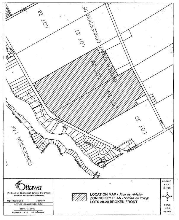
This property is located
east of River Road, west of Spratt Road, one lot north of Mitch Ownes Drive
(former Regional Road 8), and two lots south of Rideau River Road. This is a vacant field used for hay and
other cultivation having an area of approximately 74 hectares. The Heb Gordon Municipal Ditch is located in
the southeast corner of the site.
Surrounding area development consists of detached residential and
agriculturally zoned fields.
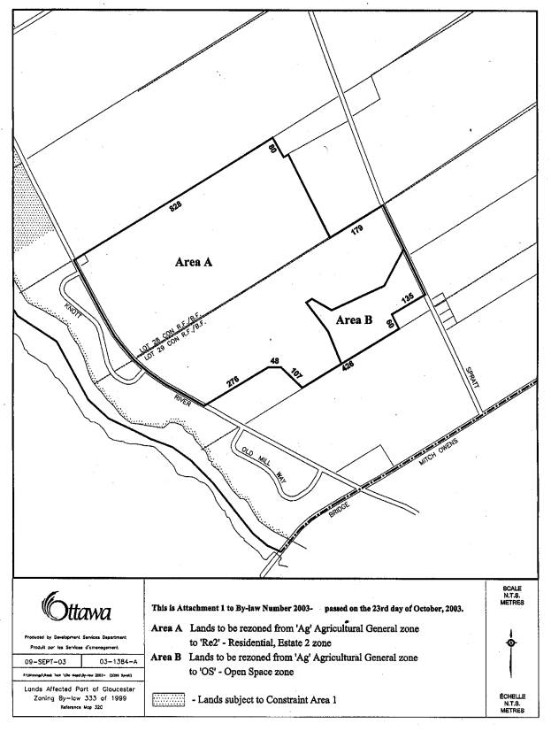
Purpose of Zoning By-law Amendment
The purpose of this Zoning
By-law Amendment is to re-zone the site from Agricultural General (Ag) to
Residential Estate (Re 2) and Open Space (OS) to permit the development of
single residential lots, and flood or
erosion control facilities. The
applicant has also applied for the subdivision of this property to accommodate
74 single residential lots having private well and septic services. The subdivision will have vehicular access
from both River Road and Spratt Road.
The OS zone is being proposed at the southeast corner of the property to
protect the function of the Heb Gordon Municipal Ditch area.
DISCUSSION
This application was
received prior to April 23, 2003, and, as such, is subject to existing
municipal policies prior to that date.
Former Regional Municipality
of Ottawa-Carleton Official Plan
This property is designated
as General Rural Area in Schedule "A" of the Rural Policy Plan. The intent the General Rural Area is allow
non-farm related uses on lands considered to have less resource potential that
other parts of the rural area. The plan
permits residential development to occur on larger country estate lots having a
minimum area of 0.8 hectares.
Former City of Gloucester
Official Plan
The lands are designated as
Limited Development on Land Use Schedule "A5" in the former City of
Gloucester Official Plan. This designation permits country lot development to
occur through a plan of subdivision provided it is deemed to be compatible with
surrounding area land uses and appropriate hydrogeological and geotechnical
studies support proposed development.
The Zoning By-law amendment
has been reviewed in conjunction with the subdivision application and was
determined to comply with the above policies.
Draft conditions of subdivision approval will ensure a comprehensive
private service review by the appropriate approval authorities prior to
development proceeding.
ENVIRONMENTAL IMPLICATIONS
The Rideau Valley
Conservation Authority has reviewed the zoning and subdivision applications and
have no objections to these applications proceeding for approval. Issues relating to the municipal drain and
the adjacent floodplain area have been dealt with though draft conditions of
subdivision approval.
RURAL IMPLICATIONS
Area residents raised a concern with respect to this development's
impact on water quality and quantity for existing residential wells. A hydrogeological study submitted with the
subdivision application the lands subject to the rezoning can support residential
estate lot development. The subdivision
will require the area's water quality to be monitored in a phased build out of
the subdivision.
CONSULTATION
Notice of this application
was carried out in accordance with the City's Public Notification and
Consultation Policy. Information signs were posted on-site indicating the
nature of the application. The Ward
Councillor is aware of this application and the staff recommendation.
Detailed responses to the
notification/circulation are provided in Document 3.
FINANCIAL IMPLICATIONS
N/A
APPLICATION PROCESS TIMELINE STATUS
The application was not
processed within the timeframe established for the processing of Zoning By-Law
amendments due to the fact that the application was placed on hold for
additional file information and clarification regarding the proponent's
representation.
SUPPORTING DOCUMENTATION
Document 1 Location Map
Document 2 Zoning Map
Document 3 Consultation Details
DISPOSITION
Department of Corporate
Services, Secretariat Services to notify the owners Wilma Booth, P.O Box 57,
Manotick, ON, K4M 1A2, Harold Keenan, P.O Box 57,Manotick, ON, K4M 1A2, Donald
Booth, P.O Box 57, Manotick, ON, K4M 1A2 and 1514658 Ontario Limited, c/o Westwood
Developments, 28 Concourse Gate, Suite 203, Ottawa, ON, K2E 7T7, All Signs,
8692 Russell Road, Navan, ON K4B 1J1,
and the Program Manager, Assessment, Department of Corporate Services of City
Council's decision.
Development Services
Department to prepare the implementing by-law, forward to Legal Services Branch
and undertake the statutory notification.
Department of Corporate
Services, Legal Services Branch to forward the implementing by-law to City
Council.
LOCATION MAP Document
1
DETAILS OF
RECOMMENDED ZONING Document
2
CONSULTATION DETAILS Document
3
NOTIFICATION
AND CONSULTATION PROCESS
Notification
and public consultation was undertaken in accordance with the Public
Notification and Public Consultation Policy approved by City Council for Zoning
By-law Amendments. A public information
meeting was held on September 4, 2004 where a number of issues relating to this
development's impact on local traffic, the potential hazard of construction
vehicles along River Road, and storm and well water qualities were raised.
SEPTEMBER 4, 2004 - PUBLIC MEETING COMMENTS
Summary of
Comments
A number of the
comments received were similar to those express by the Ward Councillor and the
local Community Association which have been respond to below. The following are summarized additional
comments received as a result of the Public Information Meeting:
1. This rezoning does not conform to the
Official Plan passed in May of this year.
2. Keep construction vehicles off of River
Road.
3. Proper lighting should be a obligation
for development approval on River Road and Spratt Road.
4. Is there a plan to widen River Road?
Response
1. As part of City Council adopting the
new Official Plan, Council also approved a policy instructing staff to review
development applications currently in process based on former municipal
policies. This application was received
prior to the adoption of the new Official Plan.
2. This was primarily a safety concern
based on the conflict between construction vehicles and heavy volumes of local
traffic. This concern has been address
through a condition of subdivision that will require the construction turning
lanes on River Road at the commencement of the subdivision's internal road
works.
3. The City standard requires all street
intersections to be lit for Residential Estate Lot development. This means that the subdivision's access
points along River Road and Spratt Road will require street lighting.
4. There are no immediate plans to widen
River Road, however, the Owner will be required to convey land for a future
road widening measuring 15.0 metres from the centreline of the pavement along
the River Road frontage as a condition of subdivision approval.
COUNCILLOR’S COMMENTS
Councillor Diane
Deans provided the following comments:
1. Has the applicant produced the
following studies:
a
Serviceability Study
a
Traffic Impact Study
a
Tree Planting and Land Conservation Plan
an
Environmental Impact Study
2. Residents have expressed concerns that
the 74 septic systems proposed will have an adverse effect on the properties to
the west since the substructure of the proposed development slopes west towards
the Rideau River. Has the consultant
addressed this concern?
3. Has the consultant's review determined
if the aquifer capacity is sufficient to serve additional housing?
4. Is the applicant required to clean up
and improve the municipal drainage ditches?
5. Will the applicant be required to
install a traffic signal at the intersection of the new development road and
River Road?
6. At the December 17, 2002 public
meeting, residents asked if the development site would have adequate parkland.
7. What landscaping features will be
included along River Road at the entrance to the new development?
8. Residents were advised that the site
plan would maintain the rural features of the land. Will this be accomplished in the plan?
9. Has the Rideau Valley Conservation
Authority provided comments on the proposal?
10. Please ensure that the buffer zone
remains between the proposed development and the private property at 5474
Spratt Road.
11. Can River Road handle an increase in
volume?
12. Will the applicant be required to
construct an additional lane, both north and south on River Road to allow
access/egress with the development site?
Response
1. These studies have been submitted in a
preliminary form with further detailed analyses required to be provided after
Draft Plan of Subdivision Approval.
2. A Preliminary Terrain Analysis and
Hydrogeological Study was submitted with the subdivision application that
recommended the usage of raised leaching beds.
This study also concluded that by employing this methodology of waste
treatment there would be no adverse effect on neighbouring properties for water
quality.
3. An amended Hydrogeolocial Study to
reflect addition test wells being drilled found there existed water yields more
than what would be required for typical residences. Additionally, this subdivision will proceed in two phases and, as
a condition for the second phase development, a follow-up Hydrogeolocial Study
will be required to reconfirm the existence of an adequate surrounding area
supply of water.
4. The extent of the works for the
cleaning up of the municipal ditch will be determined in the finalization of
the subdivision's Storm Water Management Plan.
5. A Traffic Impact Analysis will be
required by the subdivision to determine what traffic control measures will be
required at this intersection.
6. The general policy direction for
Residential Estate Lots is for cash-in-lieu of parkland dedication with the
rationale that the oversized lotting will provide for adequate greenspace and
private play areas. As such, it is
staff's position that taking of cash-in-lieu of parkland for development
off-site parkland is appropriate to be used for park development servicing the
broader community.
7. Additional planting to the satisfaction
of the City will be required along River Road as a condition of draft
subdivision approval.
8. A Tree Preservation Plan is required as
a condition of draft subdivision approval that will ensure significant pockets
of existing vegetation will be retained thereby maintaining the existing
landscape of the terrain. The
subdivision will require that the lots be no less than 0.8 hectares in size in
an effort to maintain a rural setting.
9. The Rideau Valley Conservation
Authority has reviewed this application and has provided comments that will be
incorporated in the conditions of Draft Subdivision approval.
10. This buffer will be zoned to an Open
Space designation with the subdivision requiring that this buffer remain
undisturbed by its owners.
11. Given the limited size of this
development, staff anticipates that this development will have a minimal impact
on the adjacent roads.
12. The Owner is required to construct the
intersection at River Road with left turn lanes and right turn tapers to the
satisfaction of the City.
COMMUNITY
ORGANIZATION COMMENTS
Riverside South Community Association
The Riverside South Community Association provided the following
comments:
1. This new subdivision
will create additional traffic on already crowded River and Limebank
Roads. The traffic assessment that will
be performed must look at the impact to traffic on River and Limebank Roads as
far North as Hunt Club, and also include the effects of already planned, but
not yet built, developments in the south end east of the Rideau River. In fact, in November 2002 the
"Riverside South Development Status and City Context Report" prepared
by FoTenn Consultants Inc. et. al. states that "…there is virtually no
spare capacity available today on River Road north of Limebank Road in the a.m.
peak hour…", and further states that "…there will be severe
congestion on River Road during peak periods until the proposed 4-laning has
occurred."
Clearly this development will exacerbate the problem and consideration
should be given to moving these infrastructure improvements forward to support
these new developments.
2. Construction traffic
travelling to and from this subdivision via River Road could represent a road
safety hazard. Alternate access points,
alternate routes (such as allowing only right turns in or out of the subdivision
for construction traffic), or modifications to River Road should be considered
to prevent potentially dangerous situations.
3. Concerns were expressed
at the meeting about new developments and the associated increase in runoff
causing green sludge on the shorelines further down the river. While it was
stated that it is City of Ottawa policy to require new developments to be
runoff-neutral (meaning no increase in runoff compared to the land in its
initial state), it was unclear that steps were being taken by the developer to
ensure this will be the case.
Response
1. It is estimated that
generated traffic volumes to/from (both directions) the site will be
approximately 55 and 75 in the a.m. and p.m. peak hour respectively. During the off peak hours, traffic volumes
generated from the site will be much less. Considering that these volumes will
be distributed to the north and south via River Road and Spratt Road together
with existing traffic volumes, it is assumed that the development will have a
minimal impact on the adjacent roads.
Additionally, there are a number of road projects underway within this
area. These include extension of Spratt
Road to Limebank Road and modifications to the Spratt/Limebank intersection,
upgrades to the section of Armstrong Road from east of Shoreline Drive to
Limebank Road. Further, the
Transportation Master Plan has identified plans to widen Riverside to 4 lanes
from Hunt Club Road to Limebank Road, and plans to widen Armstrong Road to 4
lanes, all by 2008 to accommodate the increased traffic in the area. It should be noted that Limebank Road is
planned to be widened to 4 lanes by 2013.
2. The Owner is required
to construct the intersection at River Road with left turn lanes and right turn
tapers to the satisfaction of the City.
These works have been required as part of the initial construction of
the subdivision road network.
3. A Preliminary Terrain
Analysis and Hydrogeological Study was submitted with the subdivision
application that recommended the usage of raised leaching beds. This study also concluded that by employing
this methodology of waste treatment there would be no adverse effect on water
quality for neighbouring properties nor the water quality of the Rideau
River. The findings of this study have been
accepted by the Rideau Valley Conservation Authority.
Old Mill Run
Community Association (Unregistered)
The Old Mill Run
Community Association is opposed to the rezoning for the following reasons:
1. Lack of a study to analyze the effect
of 74 new wells & septic systems on water quality.
2. Storm sewers should be use for drainage
to provide protection from possible polluted stagnant water in roadside ditches
(West Nile virus).
3. What is the plan with respect to fire
protection for a subdivision without fire hydrants?
4. The environmental impact on existing
creek serving as a habitat for birds and other wildlife.
5. The access to and amount of addition
traffic on River Road will result in more accidents.
6. There is a lack of local schooling and
the issue of busing children.
Response
1. A Hydrogeological Study was submitted
with the subdivision application that confirmed the existence of an adequate
supply of water for the development to proceed without negatively impacting on
area water quality.
2. The storm water and drainage plan that
will be finalized prior to the registration of the subdivision will be
engineered is such a way that extended ponding of water for more that two to
three days will not occur in the subdivision's ditches.
3. In the case Residential Estate Lots,
water tanks are typically trucked in for fire fighting.
4. The environmentally sensitive area will
be zoned "Open Space" with the subdivision requiring that this buffer
remain undisturbed.
5. The
increase in traffic resulting from the development of this subdivision will be
minimal and the design of River Road intersection will comply with City
standards that will include a left turning lane and right turning tapers.
6. The school boards have been circulated
the zoning application and have no objections to the City approving the
application.
ZONING - 965 RIVER ROAD
ZONAGE - 965, CHEMIN RIVER
Chair Hunter
began by reading a statement required under the Planning Act, which advised that anyone who intended to appeal this
proposed Zoning By-law Amendment to the Ontario Municipal Board (OMB), must
either voice their objections at the public meeting, or submit their comments
in writing prior to the amendment being adopted by City Council. Failure to do
so could result in refusal/dismissal of the appeal by the OMB.
Colin White,
Program Manager, Development Review (South), provided a succinct presentation
on behalf of Prescott McDonald, the project planner on the application, and was
available to respond to any questions on departmental report dated 8 October
2003.
Councillor Cullen
received confirmation this is estate lot development consistent with the
current ROP, the Gloucester OP, but would be discouraged in the new OP. The Councillor went on to state the
application was completed before the new OP was adopted and as such, was
legally before Committee.
The Committee
heard from the following delegations:
James R.
McIninch, Solicitor for Rita and Marthe Baizana, owners/residents on Spratt
Road, which abuts the lower right-hand corner of the subject lands. This matter was before the OMB in 2001, with
his clients as appellants under the Gloucester Zoning By-Law as well as the
City. The appellants were successful at
the Board and the Zoning By-Law, which would have permitted one acre estate
lots, was repealed by the Board. The
current Draft Plan of Subdivision provides for a 7.88 ha. block, Block 75,
which abuts his client’s property and captures the creek and the municipal
drain. The draft Zoning By-Law
Amendment before the committee proposes to zone that block, shown as Area B on
the zoning map Open Space. His clients
support that and are very anxious and encouraged that zoning will be
maintained, which precludes residential development in close proximity to their
lands. As well as residing on these
premises, they also operate a dog kennel and it was the adverse impact consideration
that brought them into the process in 2001.
He respectfully submitted that Area B will be preserved as open space in
the Committee recommendation to Council.
Jim Burke did not oppose
the development of this land, but did oppose the approval of the development
based on preliminary reports. As a
resident of Knot Crescent, located on the west side of the proposed area, he
indicated there is a slope from Area A to the water line that clearly raises
issues on drainage and water quality.
These issues were raised at the last forum regarding this development,
along with the studies undertaken and the protection thereof, with the proposed
erection of the 75 new homes.
There has been no
assurance of the impact on existing communities that surround that
development. More information should be
forthcoming on these studies to allow for an informed decision.
Chair Hunter
indicated that preliminary is just that.
Each lot must prove there is adequate water supply available without
impinging upon the water supply of others and there has to be a drainage
plan. These are important matters of
subdivision approval, but the subdivision agreement is not before
Committee. The Chair asked staff to
outline the process, if the zoning is approved and what assurances are in place
for Mr. Burke, which was provided by Ms. Currie and Mr. Morrison.
Responding to
further questions by Mr. Burke, Chair Hunter clarified that Subdivision
Approval is delegated to staff and suggested he contact the RVCA to ensure they
were aware of his concerns. Ms. Currie
added that since subdivision approval is delegated to staff, Mr. Burke should
contact the planner on file, Prescott McDonald, to ensure those concerns are
taken into consideration throughout the process.
Miguel Tremblay,
FoTenn Consultants, who represented the four property owners, was
available to respond to any questions.
Preliminary reports are provided, in particular the preliminary
stormwater report, since they are not at the construction stage and those
studies will be embellished. The
hydrogeology report is a final report and attached to the Purchase and Sale
Agreement and will guide development on each lot. Mr. Morrison is correct that it was reviewed by the RVCA and
there are no issues with ground water.
With respect to any contaminates to off-site wells, the hydrogeology and
terrain analysis recommended raised leaching beds to address any potential for
contaminants; however, none were raised in the report and that was confirmed
when the RVCA reviewed and approved the report. There are some conditions in the draft conditions, which will be
released by the City shortly. With
respect to drainage, Area B currently accommodates the Herb Gordon Municipal
Drain and the intent is for the most part to drain the property back into that
facility and they will be embellishing it to some degree. On Councillor Cullen’s inquiries, the
application was initially submitted in August 2002, deemed complete in
September 2002, well ahead of the new OP policies. The new OP, which is under review by the Ministry, does open the
door for limited country lot subdivisions, providing the designation in place
at this time accommodate that. Given
that the local OP designation is limited development, this subdivision would
qualify under the new OP, given its separation from village and urban
boundaries. Since this is being
processed under ROP policies, there is a policy that states 40 lots can be
registered at a time. After the initial
40 lots, the hydrogeology report has to be revised to factor in the effects of
those lots on ground water and confirm to the City that future lots, in this
case, the remaining 35 lots, have sufficient water along with all adjacent
wells. The Regional Policies will protect
ground water in this area.
Councillor Cullen
understood that under the current ROP and zoning, this is a permitted
development, but posited it is low density urban sprawl and precisely why the
new OP would not contemplate this. He
could not support this inefficient land use with 74 residences in a large area,
adding more traffic to River Road.
There will be more pressure on the aqueducts, which is why staff
recommended and Council did not support this kind of development.
The Committee approved the departmental recommendation.
That the Planning
and Development Committee recommend Council approve an amendment to the former
City of Gloucester Zoning By-Law to change the zoning of 965 River Road from
Agricultural General (Ag) to Residential Estate (Re 2) and Open Space (OS) to
permit the development of single unit residential lots and flood or erosion
control facilities as shown in Document 2.
CARRIED
Councillor Cullen
dissented.