8. ORLÉANS INDUSTRIAL PARK LAND USE AND DESIGN STUDY: URBAN DESIGN
GUIDELINES
ÉTUDE D’UTILISATION DU SOL ET DE CONCEPTION DU PARC INDUSTRIEL
D’ORLÉANS : LIGNES DIRECTRICES DE CONCEPTION URBAINE
|
COMMITTEE RECOMMENDATIONS
That Council:
1. Approve the Orléans Industrial Park Land Use and Design
Study: Urban Design Guidelines (Document 2) as a Guideline which provides
direction to future development fronting onto Innes Road and within the Orléans
Industrial Park.
2. Revise Annex 3 of the Official Plan to identify the study as
a statement of Council policy.
3. Direct staff to undertake a review of the Industrial Park's
zoning provisions (ie. lot coverage, landscape provisions, setbacks) to make
them consistent with the study guidelines.
RECOMMANDATIONS DU COMITÉ
Que le Conseil :
1. d'approuver l'Étude
d'utilisation du sol et de conception du parc industriel d'Orléans : Lignes
directrices de conception urbaine (document 2) comme ligne directrice pour
l'orientation de l'aménagement futur donnant sur le chemin Innes et dans le
parc industriel d'Orléans;
2. de revoir l'annexe 3
du Plan officiel afin de préciser que l'étude équivaut à un énoncé de la
politique du Conseil;
3. de charger le
personnel d'entreprendre un examen des dispositions de zonage du parc
industriel (p. ex., superficie du lot, dispositions relatives à l'aménagement
paysager, marges de retrait) afin de les rendre conformes aux lignes
directrices de l'étude.
Documentation
1. Development Services Department General
Manager’s report dated 6 October 2003 (ACS2003-DEV-APR-0217).
2. Extract
of Draft Minutes, 23 October 2003.
Report
to/Rapport au :
Planning
and Development Committee
Comité de l'urbanisme et de l'aménagement
and Council / et au Conseil
6 October 2003 / le 6 octobre
2003
Submitted by/Soumis par : Ned Lathrop, General
Manager/Directeur général,
Development Services/Services d'aménagement
Contact Person/Personne ressource : Karen Currie,
Manager / Gestionnaire
Development
Approvals / Approbation des demandes d’aménagement
(613)
580-2424 x28310, karen.currie@ottawa.ca
|
Ref N°: ACS2003-DEV-APR-0217
|
|
SUBJECT:
|
ORLÉANS INDUSTRIAL PARK LAND USE AND DESIGN STUDY:
URBAN DESIGN GUIDELINES
|
|
|
|
|
OBJET
:
|
ÉTUDE
D'UTILISATION DU SOL ET DE CONCEPTION DU PARC INDUSTRIEL D'ORLÉANS : LIGNES
DIRECTRICES DE CONCEPTION URBAINE
|
REPORT
RECOMMENDATIONS
That
the Planning and Development Committee recommend Council:
1. Approve the Orléans Industrial Park
Land Use and Design Study: Urban Design Guidelines (Document 2) as a Guideline
which provides direction to future development fronting onto Innes Road and
within the Orléans Industrial Park.
2. Revise Annex 3 of the Official Plan to
identify the study as a statement of Council policy.
3. Direct staff to undertake a review of
the Industrial Park's zoning provisions (ie. lot coverage, landscape provisions,
setbacks) to make them consistent with the study guidelines.
RECOMMENDATION DU RAPPORT
Que le Comité de l'urbanisme et de l'aménagement recommande au Conseil :
1. d'approuver
l'Étude d'utilisation du sol et de conception du parc industriel d'Orléans :
Lignes directrices de conception urbaine (document 2) comme ligne directrice
pour l'orientation de l'aménagement futur donnant sur le chemin Innes et dans
le parc industriel d'Orléans;
2. de revoir l'annexe 3 du
Plan officiel afin de préciser que l'étude équivaut à un énoncé de la politique
du Conseil;
3. de charger le personnel
d'entreprendre un examen des dispositions de zonage du parc industriel (p. ex.,
superficie du lot, dispositions relatives à l'aménagement paysager, marges de
retrait) afin de les rendre conformes aux lignes directrices de l'étude.
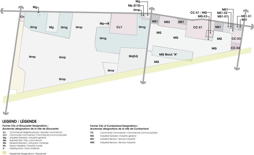
BACKGROUND
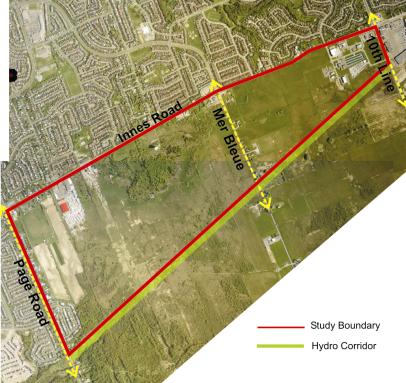
The Orléans Industrial Park
Land Use and Design Study, examines lands south of Innes Road and north of the
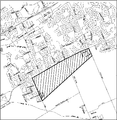
hydro corridor between Pagé Road and Tenth Line Road. The study area, shown in Document 1, is approximately 316
hectares (781 acres) in size and is located within both the former Cities of
Gloucester and Cumberland.
Under the new Official Plan,
the majority of the study area is designated Employment Area with a small
portion designated Mixed-Use Centre.
The study area is regulated by the Zoning By-laws of the former Cities
of Gloucester and Cumberland. The
primary designations are industrial and business park zones, however, there is
some commercial zoning and a small area along Pagé Road is zoned
residential. The design guidelines do
not propose to change the zones or permitted uses in the zoning by-law. The design guidelines will be applicable to
all future built form, in the study area, irrespective of the use.
The Orléans Industrial Park
Land Use and Design Study was initiated due to increasing development pressure
on the Innes Road corridor and the desire to shape an overall vision for future
development fronting onto Innes Road and within the Industrial Park. The intent of the study is to establish
Urban Design Guidelines and development requirements to help direct the visual
image of future development.
The guidelines are divided
into broad sections dealing with site planning, architecture and the pedestrian
environment. The site planning guidelines discuss how development can be
sensitively integrated with the existing context, how it can contribute to the
visual image of the area, and how it can address functional requirements such
as safe and efficient circulation. The guidelines recommend accentuating prominent
intersections, corner sites and key gateways through built form and landscape
design. Key guidelines recommend
reinforcing public streets by reducing setbacks and siting buildings up to the
street. They also recommend creating
active facades with a high percentage of transparency and architectural
detailing.
The architectural guidelines illustrate how, through consideration
of aesthetic and functional requirements, new buildings can be designed to
address human scale and contribute to an active pedestrian environment. In addition to increasing the visual
prominence of buildings, the guidelines recommend reducing the prominence of
parking areas by locating at the rear of buildings or effectively screened from
adjacent pedestrian areas and public streets.
The guidelines discuss the creation of a convenient, accessible and
linked pedestrian realm. This should be
a barrier-free network of sidewalks and walkways that clearly links development
sites within the Industrial Park to each other and to surrounding off-site
uses.
Key landscape guidelines
discuss the need for street trees on all public boulevards as well as the use
of landscaping to highlight entry points, to screen unsightly elements, and to
buffer adjacent residential zones from future industrial uses.
In addition to urban design
guidelines, the study delineates a collector road network within the Industrial
Park area. This network sets the
framework for future development and the subdivision of land. The extensions of Vanguard Drive and Belcourt
Boulevard are identified as the primary east-west and north-south collectors
through the site.
The urban design guidelines
are to be used as a framework to direct the preparation of development
applications and to evaluate
submissions in the development review process.
The design guidelines are meant to ensure that future development
achieves a consistently high level of site planning, architecture and landscape
design.
CONSULTATION
Public consultation during
this study included letters to property owners and community groups and
consultation with these when requested.
Two public open houses were held during the course of the study. The first was held on June 23, 2003, to
which all landowners within and directly adjacent to the study area were
invited, and for which additional notice was provided in two community
newspapers and the appropriate daily newspapers. A second open house was held on September 8, 2003. This was advertised in two community
newspapers. Additonally, letters were
sent to all those who, at the first open house, identified a desire to be
informed of upcoming public meetings.
Eight written comments were
received after the second open house.
These focussed primarily on questions about the timing and specific
design of the Innes Road widening.
Residents adjacent to the study area also expressed the desire for
adequate buffering of residential areas from future large scale devlopment in
the Industrial Park.
Ward Councillors Rainer
Bloess and Phil McNeely were kept abreast of this study and all open house
meetings.
FINANCIAL
IMPLICATIONS
N/A
SUPPORTING DOCUMENTATION
Document
1 - Location Map
Document
2 - Orléans Industrial Park Land Use and
Design Study: Urban Design Guidelines draft document
DISPOSITION
City Clerk to notify the
Development Services Department of City Council's decision.
LOCATION MAP Document
1
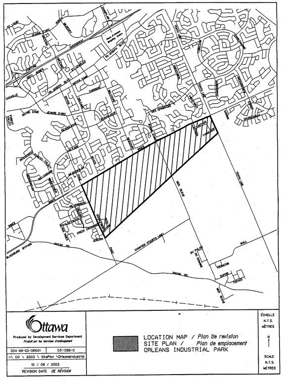
ORLÉANS
INDUSTRIAL PARK LAND USE AND DESIGN STUDY :
URBAN DESIGN GUIDELINES DRAFT DOCUMENT Document
2
1.1
Background
1.2
Planning Context
1.3
Purpose and Scope of the
Guidelines
The Orléans Industrial Park
Land Use and Design Study, examines lands south of Innes Road and north of the
hydro corridor between Pagé Road and Tenth Line Road. The study area, shown in Figure 1, is
approximately 316 hectares (781 acres) in size and is located within both the
former Cities of Gloucester and Cumberland.
With increasing development
pressure on the Innes Road corridor, an overall vision for future development
fronting onto Innes Road and within the Industrial Park is required. This study establishes Urban Design Guidelines and development
requirements to help direct the visual image of this development. The study also delineates a collector road
network within the Industrial Park area.
Both the design guidelines and collector network are meant to ensure
comprehensive and sound development of Innes Road and the Orléans Industrial
Park.
As visible in Figure 2, the
lands north of Innes Road and east of Pagé Road are predominantly residential. The lands
immediately to the east of the study area are retail commercial. A Hydro One Transmission corridor borders
the south side of the study area. The lands south of the hydro corridor
are yet undeveloped however, a number of applications for residential
development have been submitted for the area west of Mer Bleue Road.
Innes Road, through the
study area, is currently a two-lane road. The road is designated for expansion to a
four lane arterial in 2004. As per the
Innes Road Environmental Assessment – completed in 2002,
the future right-of-way will be 37.5 to
40 meters wide.
To address the ongoing development to the east and south of the
study area, Mer Bleue Road and Tenth Line Road are also expected to be widened
in the future.
The future Cumberland Transitway and Blackburn Hamlet Bypass
Extension run south of and generally parallel to the hydro corridor.
The north side of Innes Road
is predominantly developed in reverse frontage single detached and row
housing. However, there are some homes
fronting onto Innes and a limited number of commercial uses. Within the study area, there are a number of
existing legal non-conforming residential uses both along Innes Road and Mer
Bleue Road. There are some commercial
uses along Innes Road; the largest of these being the Builder’s Warehouse store
just east of Boyer Road. Closer to Tenth Line Road there are additional
commercial and business park uses.
Proposed development includes
an 18.7 ha snow disposal facility planned for the lands immediately west of Mer
Bleue and adjacent to the hydro corridor and a 45,000
square meter commercial
development on the south
west corner of Innes Road and Mer Bleue. (see Figure 27 for locations).
 As
visible from Figure 3, the study area also contains a water tower, some
existing mature tree stands, and a natural rock outcrop that forms a ridge.
As
visible from Figure 3, the study area also contains a water tower, some
existing mature tree stands, and a natural rock outcrop that forms a ridge.
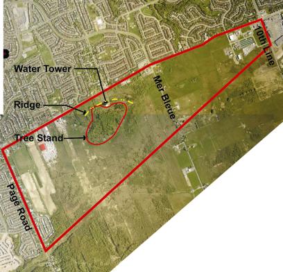
Under the new Official Plan
(adopted May 2003), the majority of the study area is designated Employment
Area with a small portion designated Mixed-Use Centre (see Figure 4).
The Employment Area
designation identifies areas where commercial, office, and
industrial uses are the main land uses.
The primary function of Employment Areas is to supply “products and
services to the city’s office and commercial sectors”; these uses may be
supported by complementary non-industrial uses (page 83). The Official
Plan notes that Employment Areas should accommodate uses totaling over 2,000
jobs.
 The
Mixed-Use Centre designation “applies to lands that have been identified as
strategic locations on the rapid-transit network and lie adjacent to major
roads…and have a high potential to achieve compact and mixed-use development” (page 73). Mixed-Use Centres are to support development
that is both locally- and regionally-oriented. The Official Plan establishes
employment targets of at least 5,000 jobs in Mixed-Use Centres. The Official Plan also notes that in the
case of this Mixed-Use Centre,
The
Mixed-Use Centre designation “applies to lands that have been identified as
strategic locations on the rapid-transit network and lie adjacent to major
roads…and have a high potential to achieve compact and mixed-use development” (page 73). Mixed-Use Centres are to support development
that is both locally- and regionally-oriented. The Official Plan establishes
employment targets of at least 5,000 jobs in Mixed-Use Centres. The Official Plan also notes that in the
case of this Mixed-Use Centre,
“development will only be
permitted after the adoption of a secondary plan by the City” (page 75). The geographic boundaries of the Mixed-Use
Centre will be fine-tuned through the secondary planning process.
 The City of
Ottawa’s current projections are for 6,700 jobs in the Employment Area and
Mixed-Use Centre, of the study area, by 2021.
The City of
Ottawa’s current projections are for 6,700 jobs in the Employment Area and
Mixed-Use Centre, of the study area, by 2021.
The study area is regulated
by the Zoning by-laws of the former Cities of Gloucester and Cumberland. The primary designations are industrial and
business park zones, however, there is some commercial zoning and a small area
along Pagé Road zoned residential (refer to Figure 5 on page 7).
The by-laws permit a variety
of industrial and employment-generating uses such as warehousing and
distribution, manufacturing, communications, office, institutional, research
and development uses. Complementary uses such as
commercial, office, service and recreational uses that meet the needs of people
working and living in the area are also permitted. The design guidelines will be applicable to all future
built form, in the study area, irrespective of the use.
The design guidelines do not
propose to change the zones or permitted uses in the zoning by-law. However, the City has recently embarked upon
a comprehensive City-wide zoning review, which is scheduled for completion in
late 2005. The results of this review
may suggest amendments to the range and type of permitted uses.
Within the study area, parkland allocation
will be taken in accordance with Planning Act requirements. However, the exact
location and type of park
space is yet to be determined. The need
for a sports field park, within the Industrial Park, has been previously
identified in the Gloucester Growth Area Recreation Master Plan (1993)
and members of the public have expressed interest in preservation of the tree
stand on site. The Orléans Master
Plan Update, to be completed in 2004, will re-examine parkland
needs, including the nature and location of new parks. It is anticipated that parkland allocation
strategy for the study area will be identified subsequent to the Master Plan
Update.
The purpose of the design
guidelines is to ensure that future development in the study area achieves a consistently high
level of site planning, architecture and landscape design. Each new development should be sensitive to
the existing context, enhance the character of the area, and contribute to
streetscapes and pedestrian environments.
The guidelines
should be used as a framework to direct the preparation of development
applications and to
evaluate submissions in the development review process. The guidelines are divided into three broad
sections dealing with site planning, architecture and the pedestrian environment. These are followed by a final section, which
discusses the proposed collector road network for the study area.
Site planning
principles and guidelines can ensure that future development responds to the
existing context, contributes to the visual image of the area, and addresses
functional requirements - such as safe and efficient circulation. The following
sections discuss site planning in terms of existing context, building location
and orientation, and parking area requirements.
The study area is
predominantly flat land that has been previously cultivated, although there are
a few contiguous tree stands. The most prominent existing features
are the natural ridge and mature tree stand around the water tower. This area is highlighted in Figure 3 on page
4. A 1992 environmental analysis of the
area describes the stand as a mature tolerant hardwood forest that is uncommon
in the City and has some environmental significance
(Gore and Storie 1992, D5-6). The City
is currently undertaking an Urban Natural Areas Environmental Evaluation Study
that should more precisely define the ecological value of the tree stand. Through sensitive site planning, the
locations of future buildings and roads can reflect the natural topography and
help protect the mature existing vegetation.
Guidelines:
§
Future road patterns and site layouts must follow the
existing contours and should highlight the ridge as a feature. The proposed collector road pattern (see
Figure 26) is sited to make this possible;
§
Grading plans should strive to incorporate the
existing landforms into site development;
§
Development applications must include a survey of
existing vegetation (location, species, size, condition etc.) and identify the
location of individual trees having trunks greater than 10cm in caliper;
§
Development applications must strive to protect and
incorporate existing mature trees into site and landscape plans and, therefore
must identify existing vegetation to be preserved;
§
Grading plans, in support of development applications,
must ensure that existing grades are maintained around trees noted for
preservation; and
§
Road grades and elevations of the proposed road
network must also ensure that existing grades are maintained around trees noted
for preservation.
Although there is little
existing built context within the Industrial Park, there are established
residential uses along Innes Road, adjacent to Pagé Road, and within the
Industrial Park. There are also some
commercial and industrial uses in the Park; most of which are located along
Innes Road and in the vicinity of Lanthier and Vanguard Drives. In all cases it is essential to ensure an
appropriate transition between existing and future uses.
The established residential
communities north of Innes Road are separated from future development in the
Industrial Park by Innes Road (37.5m – 40m right-of-way). This separation can mitigate some of the
effects of loading and service areas, light glare, and building shadow effects
on the existing homes. However, where a
residential zone backs directly onto future development lands it is important
to ensure that future development does not adversely affect the quality of the
residential area.
The following guidelines apply where this condition occurs:
Guidelines:
§
Locate all unsightly and noise-generating elements,
such as service lanes, loading zones, dumpsters and outdoor storage, away from
adjacent residential properties;
§
Separate existing residential zones which back onto
future Industrial Park uses (e.g. along Pagé Rd. and Nature Trail Cresc.) with
a landscaped buffer, located on development lands, designed to mitigate
unsightly and noise-generating elements;
§
As shown in Figure 6, the buffer should be formed by a
6m wide aesthetic berm, predominantly planted with evergreen trees that retain
their lower limbs with age. The
planting should create a continuous and dense visual screen.
§
Where the noise generated by future uses is of concern,
noise studies can be requested in accordance with City and Ministry of the
Environment policies. If deemed
necessary, noise walls can be installed in addition to the planted berm.
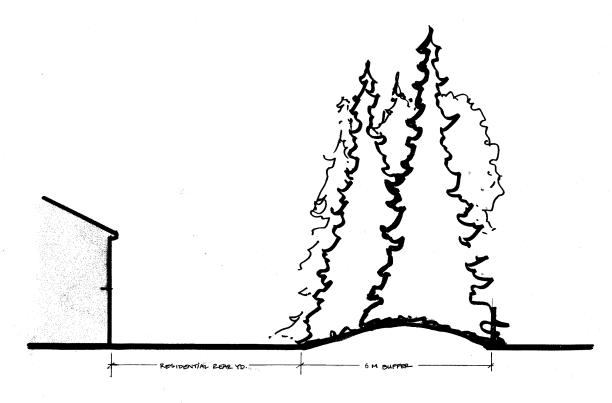
Figure
6: A 6 m landscaped buffer, located on development land, separates the
residential rear yard from the Industrial Park.
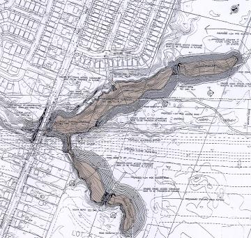
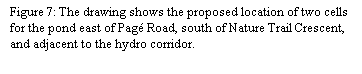
To address servicing issues
in the industrial park and surrounding area, stormwater detention ponds are
planned for the south-west corner of the study area; this is the area behind
the Longwood residential development and adjacent to the hydro corridor (Figure
7). When
the pond is built, it will be integrated into the area as a feature of the
surrounding community.
 The
City of Ottawa Official Plan identifies the hydro corridor, which runs south of
the study area, as a Major Recreational Pathway linking the industrial area to
the existing and future surrounding residential communities. Opportunities for pedestrian and bicycle access
to the pathway should exist where the pathway intersects north-south roads -
such as at the Belcourt Blvd. extension, Mer Bleue and 10th Line
Roads. There should additionally be
opportunities to access the pathway, from the industrial park, at regular
intervals along the hydro corridor. All
development proposals backing onto the hydro corridor will be encouraged to
provide connections to the recreational pathway system. To ensure that the
primary use of the corridor as a recreational pathway, parking areas and
buildings should not extend from the industrial park into the corridor.
The
City of Ottawa Official Plan identifies the hydro corridor, which runs south of
the study area, as a Major Recreational Pathway linking the industrial area to
the existing and future surrounding residential communities. Opportunities for pedestrian and bicycle access
to the pathway should exist where the pathway intersects north-south roads -
such as at the Belcourt Blvd. extension, Mer Bleue and 10th Line
Roads. There should additionally be
opportunities to access the pathway, from the industrial park, at regular
intervals along the hydro corridor. All
development proposals backing onto the hydro corridor will be encouraged to
provide connections to the recreational pathway system. To ensure that the
primary use of the corridor as a recreational pathway, parking areas and
buildings should not extend from the industrial park into the corridor.
 The site for the snow disposal facility was
purchased by the former Region of Ottawa-Carleton in the early 1990s and was
zoned to permit snow disposal prior to amalgamation. The detailed site planning and design began for the facility
began in Spring 2003 and the facility will likely be operational by 2005. The design for the facility addresses
requirements for stormwater detention and pays special attention to berming and
buffering in order to address visibility and noise concerns.
The site for the snow disposal facility was
purchased by the former Region of Ottawa-Carleton in the early 1990s and was
zoned to permit snow disposal prior to amalgamation. The detailed site planning and design began for the facility
began in Spring 2003 and the facility will likely be operational by 2005. The design for the facility addresses
requirements for stormwater detention and pays special attention to berming and
buffering in order to address visibility and noise concerns.
Site planning that carefully
locates and orients buildings can do a great deal to enhance the functionality
and aesthetic value of a development site.
It can also contribute to wayfinding and positively influence the streetscape. The following guidelines address the
relationship between the building and the street, with emphasis placed on
perimeter landscaping.
Guidelines:
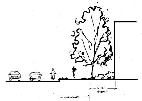
§
Reinforce public street fronts by siting buildings up
to the street.
§
Set buildings back 3 – 5 m from the front-yard
property line in order to create a continuous street frontage. (Figure 8)
§
Set buildings back 3 – 5 m from the side-yard property
line where the side yard is adjacent to a public street
§
 Landscape
the area between the building and the property line with a continuous row of street
trees and foundation planting.
Landscape
the area between the building and the property line with a continuous row of street
trees and foundation planting.
Figure 8: The built edges is
set back 3-5m from property line. The
area between the property line and the building is landscaped.
In some cases a development site may have frontage on three (or
four) streets and it would therefore be difficult to achieve a 3-5m setback on
each of these sides. In such cases, the
3-5m setback should be achieved on what is deemed to be the key street - or
streets in the case of a corner site.
Figure 9 identifies key streets and intersections within the study
area. In all cases Innes Road and the
Belcourt Blvd. extension will be considered the primary focus for built
form. Mer Bleue and 10th Line Roads, as
they pass through the study area, should be second in priority. The internal east-west collector and
remaining north-south collectors should then follow in importance.
§
Accentuate prominent intersections, corner sites, and
the entry points to large development sites.
§
High visibility corners include the intersections of
future collectors with Innes and Mer Bleue, as well as the intersection of
collectors within the Industrial Park.
(Figure 9)
Figure
9: The illustration highlights key
intersections in the study area.
§
Accentuate these locations by designing buildings and landscape
features that relate to both street fronts and provide pedestrian access to the
site and buildings from the corner. (see Section 3 & Figure 10)
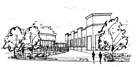
Figure 10: The pedestrian entry on a corner
development site is framed by buildings with windows that face both the
street and walkway and is highlighted with
street trees and planting beds.
§
Where natural features are adjacent to key roads and intersections,
preservation of the natural feature can be used to create a landmark within the
Industrial Park.
§
Within the study area, create opportunities for focal views to the tree
stand from primary intersections along the new north-south collector. (Belcourt
Blvd. extension)
§
Preserve the opportunity to create treed central medians, that act as
gateways, at the major intersections shown in Figure 9.
§
Front principal building entries onto public streets
and reinforce these entries so that they are clearly identifiable. (Figures 11
and 12). Entries can be reinforced by
designing extra-height lobby space, distinctive doorways, and distinctive
landscaped entry area, and also by changing paving materials, textures or
colour.
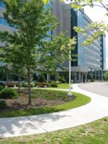
Figure 11: A change of colour and materials is used to
highlight the front entry to this building.
Figure 12: Landscaping is used to define and lead
pedestrian to the building entry.
§
Ensure that all buildings address the street and
create active facades. This can be
achieved, for example, by facing windows and doors onto the street, through
architectural design, and by defining the pedestrian realm. (see Sections 3 and
4)
§
Ensure that site plans that do not maximize permitted density are
designed to permit future intensification.
§
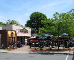
Encourage patio uses to front onto collector
roads. Patios should be avoided along
Innes Road unless noise attenuation issues are addressed.
Site planning
for all future development must ensure that parking areas do not detract from
the streetscape or the pedestrian environment.
The following guidelines will reduce the prominence of parking lots
through sensitive siting and screening.
§
Prohibit parking areas at prominent intersections.
These frontages should be reserved for built form and / or landscaped areas.
§
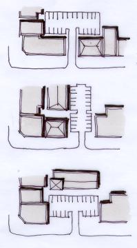
Locate surface parking lots at the rear of buildings
so that built form screens the parking field. (Figure 13)
§
Allow parking at the side or front of buildings only
when parking at the rear is impossible or where parking at the side or front is
an interim use until the land intensifies.
Figure 13: The
sketches show parking areas at the rear, side and front of buildings. Parking lots at the rear of buildings can be
screened by built form.
§
Where any portion of a parking area fronts the street,
a larger setback from the property line is required and cars must be
effectively screened from the view.
§
Provide a 7 m landscaped setback from the property
line to any parking area facing the street. (Figure 14)
§
Landscape the setback with a row of trees, planted to
create a continuous canopy, and an understorey
shrub planting. Where possible, a
second row of trees should be added.
Plant spacing and planting choices must meet the intent of these
guidelines to screen parking areas from view and to shade the sidewalk for pedestrians. Planting may be combined with aesthetic
berms, low fences or walls to achieve the
desired screening.
The screening must be effective all seasons.
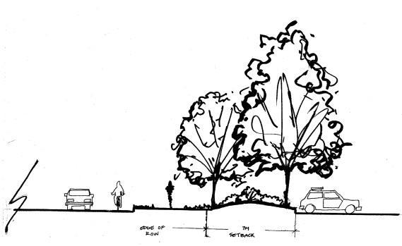
Figure
14: A landscaped buffer sets the parking area 7 m back from the property
line. A slight berm assists
in
screening the parking from view of the sidewalk.
§
Provide a 7 m landscaped setback from the property
line where stacking lanes of drive-through facilities face the street. (Figure
15)
§
Landscape the setback with a row of trees, planted to
create a continuous canopy, and an understorey shrub planting. Where possible, a second row of trees should
be added. Plant spacing and planting
choices must effectively screen the stacking lanes at all times of year. Planting may be combined with aesthetic
berms, low fences or walls to meet the screening requirement.
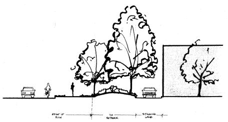
Figure
15: The plan and elevation illustrate how stacking lanes can be screened from
the pedestrian realm.
§
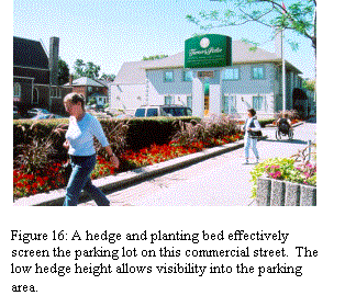
Ensure safety and security by maintaining eye level
visibility to the parking area. (Figure 16)
§
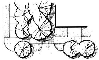
Break up large parking fields into smaller areas
through the creation of pedestrian walkways, that link to building entries, and
the addition of plant material.
§
Ensure that parking islands are no less than 2.5 m
wide and planted with deciduous trees and shrubs. Ground covers, other than grass, can be used in place of shrubs.
§
The number of access driveways should be minimized on
all roads. In Innes Road in particular,
new access locations should be limited and site access should be encouraged
through collector roads, local roads, and shared rights-of-way within the
Industrial Park.
§
In order to reduce the number of vehicular entrances,
permit shared access to parking areas located between buildings that are
located on separate properties. If
shared access is to be provided for in the future, the site plan should show
the proposed location of the access and the development agreement should make
provisions for its future installation.
New buildings along Innes
Road and within the Industrial Park must be designed to address human scale and
contribute to an active pedestrian environment. The following architectural guidelines
address both aesthetic and functional requirements of future built form.
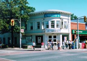
§
Create distinctive building entries that highlight façades and enhance
key intersections. (Figure 17)
§
Accentuate corner sites by designing buildings that
relate to both street fronts and provide pedestrian access to the building from
the corner. (Figure 17)
§
Ensure visibility into buildings from ground level
facades facing public streets and the pedestrian realm. Walls should be highly transparent with windows and doors
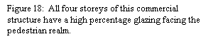
making up at least 50% of the façade. (Figure 18).
§
Ensure that large blank, unarticulated walls do not
face the street and pedestrian realm.
Blank walls include both windowless walls and walls with reflective or
highly tinted glass facades.
§
It is recognized that certain buildings will include
programmatic uses that do not lend themselves to a highly transparent façade
(e.g. loading areas, warehouse and storage functions). These buildings should be designed so that
such uses are located along walls that face away from public streets and the
pedestrian realm. The external surface
of these walls must be designed to break up the visual size of the wall’s
façade; this can be achieved through the architectural detailing of façades
noted above. In addition, the developer
will be required to increase the amount of and detail in landscape planting in
front of the wall.
§
In order to successfully
achieve these guidelines, developers are encouraged to pre-consult with the
City prior to developing the site plan and building design.
§
Ensure the highest level of architectural detailing on
facades facing public streets and the pedestrian realm. A high level of architectural detailing
should be achieved by:
§
facing windows and doors onto the street and public
realm (Figure 19);
§
modulating the façade - stepping back or extending
forward a portion of the façade (Figure 20);


§
changing the roofline to reinforce the façade
modulation;
§
incorporating merchandising display windows into
the façade (Figure 21)
§
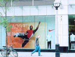
changing materials, colours, patterns, and textures
within the building plane (Figure 22);
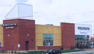
§
designing buildings with distinct bases, middles, and
upper storeys (Figure 23).

As the Industrial Park
develops, it is essential to ensure the creation of a well-defined pedestrian
environment along all public roads and within development sites. Future development also presents the
opportunity to maximize pedestrian accessibility to the proposed transitway
extension, Mixed-Use Centre, and residential developments south of the hydro
corridor. The
following guidelines are intended to ensure a convenient and linked pedestrian
environment.
The pedestrian system must:
§
be barrier-free and designed for safety and security;
§
ensure continuous sidewalks and safe crossing points;
§
connect all uses within a development (buildings,
parking areas, pad buildings etc.);
§
clearly link public sidewalks with all internal
walkways;
§
clearly link the development sites within the
Industrial Park to each other and to surrounding off-site uses (mixed-use and
residential areas); and
§
be defined with landscaping, paving, and pedestrian
scaled lighting.
All sites
should be enhanced with generous landscaping.
The following guidelines build upon those given in Sections 2.2 – 2.4
which describe requirements where planting is used to screen parking areas and
blank walls, or create buffer areas.
§
Plant the public boulevard of all streets in the
Industrial Park with street trees.
Where possible the trees should be planted between the curb and the
sidewalk.
§
Use landscaping to highlight building entries and
pedestrian connections to the street where building entries front onto the
street. (Figure 24)
Figure 24: Generous landscaping
effectively highlights the building entry and leads visitors from the public
realm.
§
Accentuate key intersections at public streets with
additional landscaping and co-ordinate landscaping with the architectural
treatment of corner sites.
§
Mark the entry points of development sites with
additional landscape features. (Figure 25)
§
Select plant species that are non-invasive, tolerant
of urban conditions, and drought resistant.
§
Preference should be given to native species that can
meet these conditions.
§
Tree spacing will vary with species selection. In all cases the intent is to create a
continuous canopy or continuous screen.
Trees may be planted in groupings - instead of rows - to achieve a similar
effect.
§
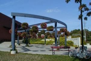
Complement planted areas with hard landscaping elements such as special
pavements (colour, texture, pattern etc.), architectural features (trellises,
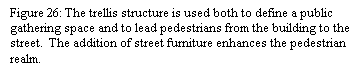
screen walls, planters etc.), and site furniture. (Figure 26)
§
As development backing onto the hydro corridor will be
visible from the future recreational pathway, establish a 3m planting strip on
private property abutting the hydro corridor.
Planting in the 3m strip should be designed to enhance the interface
between development sites and the pathway corridor.
The design and siting of
signs, lighting, and service areas all influence the quality of the pedestrian
environment. The following general
guidelines should be addressed in all future development.
§
Design signage to facilitate the orientation of both
pedestrians and people in vehicles
§
Ensure that signage is incorporated within the
architectural design of buildings
§
Consolidate site signage in order to reduce visual
clutter
§
Ensure that signs are designed and placed in a manner
that is safe for vehicular and pedestrian circulation
§
Locate signage in a manner that will be contiguous
throughout the area (e.g. above principle entrances, at vehicular and
pedestrian entranceways etc) so that the public can easily find their
destination
§
Prohibit temporary or portable signs such as, but not
limited to, billboards, revolving signs, gas-filled inflatable devices, roof
signs, sandwich boards etc.
§
Ensure that lighting provides sufficient visibility
for safety and security. A lighting
plan may be required for large development sites
§
Design lighting to minimize the impact on adjacent
land uses, in particular on existing residential development
§
Use shielding and /or sharp cut-off lighting where
necessary and appropriate to reduce glare and light spillover
§
Locate all mechanical, service areas, and utility
areas as well as unsightly and noise-generating elements, such as service
lanes, loading zones, dumpsters and outdoor storage, rooftop mechanical units,
away from the pedestrian realm, public streets, and residential areas.
§
Where mechanical and service areas are away from the
public realm but, can still be seen, they must be screened from view on all
sides in a manner that complements the buildings. Planting should be incorporated to enhance the screening effect.
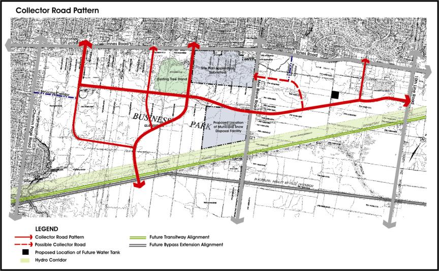
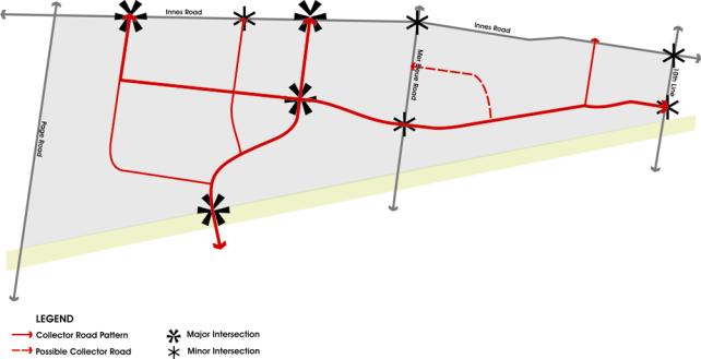
Figure 27
shows the concept plan for a preferred collector road pattern through the
Industrial Park. This pattern is a
refinement of two previous conceptual options.
The preferred pattern was determined in conjunction with the EUC Master
Servicing Plan Update. It was also
based on information from the Innes Road Environmental Assessment, public
consultation, and knowledge of future developments to the south and east of the
study area.
The concept plan identifies
a proposed major and minor collector road network. This network sets the framework for future development and the
subdivision of land. The concept plan
identifies the extension of Vanguard Drive as a
primary east-west collector through the site. As given in the Gloucester Official
Plan Amendment #35, the extension of Belcourt Boulevard is shown as a primary north-south
collector. The concept plan does not
show a local road pattern, as this will develop out of the subdivision process. If
necessary, the alignment of the proposed collector roads may be fine-tuned in
the subdivision process. Depending on
site conditions and future development, there may be a need for an additional
north-south connection, between Lanthier Drive and Mer Bleue Road. This connection would take on the character
of a local road and not a collector.
All collector roads should be designed with sidewalks on both sides of
the street and future local roads should include sidewalks on one side. As noted in Section 4.1, all public
boulevards should be planted with street trees.
The proposed location of a
new water tower and servicing blocks required for the future development of the
Industrial Park and surrounding area are shown on Figure 27.
This document reflects Council’s vision to guide future
development fronting on Innes Road as well as within the overall Industrial
Park and is referenced on Annex 3 to the City’s Official Plan. The urban design guidelines and development
requirements contained herein shall be used as a framework to direct the
preparation of development applications as well as an evaluation tool to review
submissions in the development review process.
It is understood that some flexibility in interpreting
the guidelines is permitted, provided the general intent and overall vision is
maintained.
Following Council adoption of the guidelines, staff
will initiate a review of the zoning provisions for all lands within the study
area to recommend amendments to key zoning provisions (e.g. landscape
provisions, building setbacks) to ensure that the built form and aesthetic
images suggested in the document are achievable without the need for proponent
initiated variances and zoning amendments.