DETAILS OF RECOMMENDED ZONING Document 3
The
following is an explanation of the zones and special exceptions being proposed
for the development. The proposed zoning amendment for the property
implements the draft plan of subdivision for the Lester Road lands. It is also
proposes to use similar zones to those already used in the first phase of the
Canada Lands Project on Queensdale Drive.
·
Sawmill Creek, the lands adjacent to the creek, a linear park, pathways
surrounding the site, a soccer field as well as a woodlot along Lester Road are
proposed to remain zoned OS (Open Space).
The OS Zone applies to Blocks 111, 112, 113, 126, 129, 130 and 131.
·
The
multiple unit development blocks (Blocks 127 and 128) will be zoned Ra2 (Medium
Density Apartment),
·
the adult
lifestyle portion of the development (Block 124) will be zoned Rc2 (Mixed
Residential),
·
the small
mixed use block at the corner of Lester and Albion will be zoned CN
(Neighbourhood Commercial) with limited uses; and
·
the rest of
the residential area is proposed as Rc2 (Mixed Residential) which permits
single, semi detached and row dwellings.
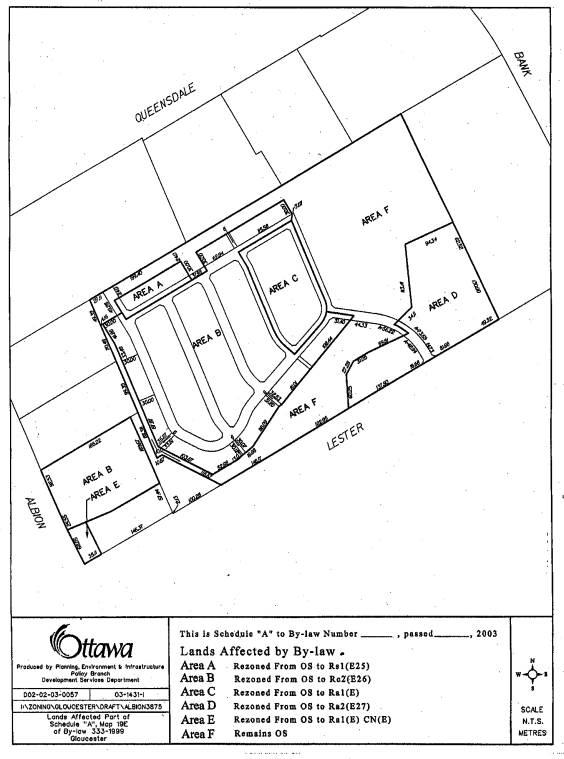
There are
six different zoning categories proposed for these lands, as depicted in the
attached plan.
ZONE 1: Rs1
(Exception XX) – Residential, Single Dwelling
The Rs1
zone is proposed for Lots 1 to 10, which are located south of the Promenade
Park and proposed to be Single Family with Garage Annex. The Rs1 zone is a residential single-family
zone that permits single dwellings as the primary use. It is intended that these homes face the
Promenade Park, which would reflect a layout consistent with the development of
the homes located north of the Promenade Park (Albion/Queensdale subdivision).
The proposed zoning for this area would be similar to that of the Rs1(E25)
zone. This exception zone is currently
in effect in the Gloucester Zoning By-law and was created for the CLC
Albion/Queensdale subdivision in order to allow single family homes, with
street-oriented garages and accessory apartments located above the detached
garages.
ZONE 2: Rc2
Zone (Exception XX): Mixed Residential Dwelling
The Rc2 zone is proposed for Lots 11 to
110, Blocks 114 to 120 and Blocks 122 and 123.
These lots and blocks comprise the majority of the site and generally
consist of its interior portion, backing onto Sawmill Creek, the Promenade Park
or Open Space areas. The Rc2 zone will permit a range of residential uses
including single-family dwellings, semi-detached dwellings, row dwellings and
street row dwellings. In order to
maintain the desired neo-traditional approach to this development, the proposed
zoning for this portion of the site would be similar to the Rc2(Rc2 (E26) zone. This exception zone, created as part of the
Albion/Queensdale Subdivision, allows for reduced building setbacks, as well as
reduced projections for building features such as porches.
In addition to the provisions of the Rc2(Rc2 (E26) zone, the
following variations are requested:
In order to
achieve a neo-traditional streetscape, there is a requirement to ensure that
buildings are located close to the street.
This means replacing the minimum front yard setback requirement and
introducing a “build-to line”. This
means requiring a maximum front yard setback, replacing the standard
minimum front yard setback. This
build-to-line would be set at 3 metres and only apply to the residence, not the
garage, which will be set further back at least 4 metres or more depending on
the sidewalk location. In order to do
so, a definition of ‘build-to-line’ would also be added to Section 2.0
(Definitions) of the Gloucester Zoning By-law.
The Rc2 zone (Exception 26 +) is also proposed for Block 124, which is
accessed from Albion Road and connected to the remainder of the site by an
internal pathway. This Block is
proposed to be developed as the ‘adult lifestyle’ portion of the development. The Rc2 zone, along with exception 26 and
the above-mentioned variations would allow for this type of development.
ZONE
3: Ra1 Zone – Interior (Exception) – Low Density Apartment
Block 121 is proposed to be
developed as a row dwelling block with an internal roadway. Because of the site characteristics in this
area, the proposed housing type may also include stacked townhome units which
are considered ‘apartment dwellings’ in the Gloucester Zoning By-law. Therefore, a Ra2 zone is being requested. This zone would allow row dwellings as well
as stacked townhome units at the desired density. However, the height limit for an apartment building is greater
than what is anticipated for this development, therefore, the following
variation to the Ra2 zone is also being proposed:
·
The maximum building height provisions (Section 6.15.4 – 17a) should be
revised to reduce the permitted height limit for an apartment from 22 metres to
10.7 metres, or 3 storeys whichever is less.
ZONE
4 Ra2 Zone (E27) – Medium
Density Apartment
The Ra2 zone will provide the potential for low-rise apartments on
Blocks 127 and 128, both adjacent to Lester Road at the entrance of the
site. While the density in the Ra2 zone
is appropriate, the permitted height limit is, once again, greater than what is
anticipated for this development. In
this regard, the proposed zoning would be that of the Ra2 (E27) zone, approved
as part of the Albion/Queensdale Subdivision.
This exception zone reduced the permitted height limit to 13.7 metres (4
storeys) and introduced a minimum lot area of 0.25ha.
ZONE 5 Commercial
Neighbourhood (Exception)
Because of its prominent location at the
corner of Albion Road and Lester Road, CLC believes that this block could
develop as a small-scale mixed-use pocket serving the needs of the immediate
residents and/or as a medium density apartment zone. In order to do so, a flexible zoning must be put in place, which
would allow residential uses, neighbourhood commercial uses, as well as
a combination of both. The proposed
zoning would allow apartment dwellings (second floor and above), as well as the
introduction of small-scale non-residential uses. The proposed zoning would require the creation of an exception to
the Cn zone - Commercial Neighbourhood Zone, to only allow the following
non-residential uses:
·
Commercial office;
·
Convenience store;
·
Day nursery, licensed;
·
Institutional uses;
·
Medical and/or dental office or clinic;
·
Personal service business.
ZONE 6 OS – Open Space
Blocks 111, 112, 113, 126, 129, 130
and 131 are identified to remain as OS – Open Space. The OS zone is being proposed to accommodate the community park
system (Block 111, 112, 126 and Block 130 – soccer pitch) and the stormwater
management facility which will complement the stormwater management facility
approved as part of the Albion/Queensdale Plan of Subdivision for the lands to
the north (OLV2002-0010).
The permitted main uses of the OS zone have been reviewed in the
context of this development. It has
been assumed that ‘flood or erosion control facilities’ include stormwater
management ponds. Therefore, at this
time, site specific amendments to the OS zone are not required.
Draft Zoning Schedule:
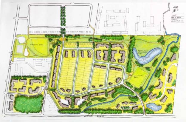
DEVELOPMENT CONCEPT PLAN Document
4
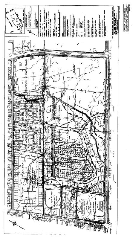
DRAFT PLAN OF SUBDIVISION Document
5
Draft Subdivision Approval Conditions Document
6
|
RECOMMENDED CONDITIONS FOR DRAFT APPROVAL CANADA LANDS PLAN OF SUBDIVISION 2901 LESTER RD between
Albion & Bank Street, former City of Gloucester WARD (10) PLANNING AND DEVELOPMENT
COMMITTEE |
|
|
Site
Location: |
2901 Lester Road[U7] |
|
File
No.: |
D07-16-03-0012
[U8] |
|
Date
of Application: |
March 27, 2003[U9] |
This application submitted by FoTenn Consultants Inc.[U10] on
behalf of Canada Lands CorporationCompany[U11] is
APPROVED as shown on the following plan:
Draft Plan of Subdivision certified by, Ed Herweyer,
Ontario Land Surveyor, dated February 13, 2003, showing the proposed
development and dated as originally received by the City of
Ottawa on March 27, 2003[U12].
And subject to the following Standard and Special
Conditions:
Draft Conditions
GENERAL
1.
The Owner agrees, by
entering into a Subdivision Agreement, to satisfy all terms, conditions and
obligations, financial and otherwise, of the City of Ottawa, at its sole
expense, including, but not limited to, the phasing of the subdivision registration,
the design and construction of roads, services, utilities and drainage, in
accordance with City Specifications and Standards all to the satisfaction of
the City.
2. The
Owner shall be responsible for the provision of the following services, including
oversizing, at its cost, to the satisfaction of the City and/or the Province:
a) watermains
b) sanitary sewers
c) storm sewers
d) roads
e) street lights
f) sidewalks
g) landscaping
h)
street name and traffic signs
i)
stormwater management facilities
3. Prior to any further division of lots
or blocks, the City of Ottawa may require an additional agreement to address
any new or amended conditions.
4. The
Owner shall obtain such permits as may be required from Municipal or Provincial
authorities and shall file copies thereof with the General Manager, Development
Services.
5. The Owner shall
design and construct, at no cost to the City of Ottawa, soft-surfaced paved, public,
all-season pedestrian walkways on all permanent servicing easements.
6. The Owner agrees to provide
servicing to Blocks 124 and 125 in a manner satisfactory to the City of Ottawa,
including the possibility of merging those blocks if appropriate servicing
arrangements cannot be implemented.The Owner
agrees that Block 125 shall not be developed except in conjunction with the
adjacent lands situated to the north (Block 124).
7.
The Owner shall assume ownership and the maintenance
costs of the pond facility as it benefits only one parcel of land (Block
128). Block 128 and Block 129 (portion
required for stormwater pond) shall be merged into one BLOCK. The construction and long term maintenance
of the pond facility will be the responsibility of the owner of Block 128.
8.
The Owner acknowledges the pump station and forcemain will be privately
owned and operated by the developer of Block 128. The Owner shall enter into a franchise agreement with the city
regarding the sanitary force main to be constructed within Street No.1.
9. The Owner shall revise the walkway width between Blocks 116 and 117 on the final 4m-plan to accommodate the proposed servicing.
10. The Owner should review the existing
services for CCC #164 to ensure there are no crossing conflicts with the
proposed storm, sanitary & watermain.
The Owner shall use its best efforts to negotiate
a servicing easement from Condominium #164 to permit servicing of Blocks 124
&125. The City will not release the
0.30m reserve abutting Albion Road until it can be demonstrated that the
required services are available to Blocks 124 &125.
11. The Owner shall provide additional servicing
information concerning Block 125, to ensure that servicing does not extend
through an adjacent private block. The
Owner may merge Block 125 with Block 124 and/or consider developing a
municipally owned road on Block 124.
12.11. The
Owner shall identify the location of Street No. 3 on the final 4M –plan as
determined by the “as-built” location of the existing storm sewer, with the
centerline alignment established based on conventional location of a trunk
storm sewer in the right of way.
123. The Owner agrees to update the “Lester
Road Serviceability Study” prepared by Stantec Consulting Ltd. dated January
31, 2003 (revised August 12, 2003) to clarify the servicing options for these
lands.
134. The Owner shall convey to the City, all
lands required for public purposes, including but not limited to, reserves,
road widenings, daylighting triangles, walkway blocks, open space blocks, lands
required for parks or cash-in-lieu thereof and for storm water measures, to the
satisfaction of the Director, Planning and Infrastructure Approvals.
Highways/Roads
145. The
Owner shall design and construct the intersection of Street No1 and Lester Road
(to City standards, including street lighting, left turn lanes and right turn
tapers) to the satisfaction of the General Manager, Development Services.
156. The
Owner shall be required to construct that portion of the proposed northern access roadway (Block
65 & 66,4M-______) that are outside the limits of the Draft Plan of
Subdivision, but are required to permit access (outlet) for this subdivision.
167. The
Owner shall dedicate the proposed streets, as shown on the plan as public
highways, to the City.
178. The
Owner shall name all streets to the satisfaction of the General Manager,
Development Services of the City.
189. The Owner shall conform to the City's
Street Numbering By-law.
1920. The
Owner shall revise the right-of-way width of Street No.1 from 18.0 metres to
20.0 metres, if required, to the satisfaction of the Director, Planning and
Infrastructure Approvals.
201. The Owner agrees to review the width of
Stedman Street to allow the provision of services including a sidewalk in an
18.0 metre right-of-way and, if required, widen the right-of-way to 20.0 metres
prior to final approval.
212. The Owner agrees that prior to final plan approval, the owner, in
consultation with the RVCA, the Department of Fisheries and Oceans, and the
City of Ottawa, shall:
a) determine
the nature, function and appropriate location of the tributary in Block 127,
and
b) together
with a) above, also determine the appropriate location of Street No. 1 to
ensure the acceptable servicing of abutting blocks."
223. The Owner shall convey at no cost to the
City a 0.30 m reserve in the following locations:
a)
Block 125 abutting Lester Road
b)
Block 125 abutting Albion Rd
c)
Block 124 abutting Albion Road
d)
Block 128 abutting Lester Road
234. The owner shall convey to the City, at no
cost, an unencumbered road widening along Lester Road, measuring 18.75 metres
from the existing centreline of pavement.
The owner's certificate on the M-Plan shall indicate which Block(s)
(are) being dedicated as a public highway of the City of Ottawa, which plan
shall be submitted in draft to the City Surveyor.
245. The Owner shall design and construct, at
no cost to the City, streets which have been identified for potential transit
services, to Transportation Association of Canada standards, including
right-of-way width, horizontal and vertical geometry, and pavement structure
and the construction of a sidewalk on both sides of the streets
256. Sight triangles at intersections between
side streets and arterial/collector roads shall be 10.0m by 10.0m, all other
sight triangles shall be 5.0m by 5.0m, to the satisfaction of the City of
Ottawa.
267. The Owner shall undertake, if required, a
Transportation Impact Study certified by a Professional Engineer with expertise
in undertaking such studies which complies with the City of Ottawa’s
Transportation Impact Study Guidelines in identifying Transportation Demand
Management measures and analyzing traffic impacts, transit impacts and
implications for pedestrian and bicycle movements. The methodology and analysis principles shall be to the
satisfaction of the Director, Planning and Infrastructure Approvals.
Sidewalks,
Walkways and Fencing
278. The
Owner shall construct a sidewalk on the east/north side of Stedman Street from
Parking Circle to Street No 1.
289. The
Owner shall construct a sidewalk on the east side of Street No. 1 from Street
No. 2 to Lester Road.
2930. The
Owner shall erect permanent fencing, without gates, to City
of Ottawa standards, along the rear lot lines of Blocks 117, 118, 119, 120, 128
and 129 (if applicable).
Land/Streetscaping
301. The
Owner shall supply to the Director, Planning and Infrastructure Approvals
streetscape planting plans for approval prior to the acquisition of
building permits. Said plans shall be
prepared by a Landscape Architect registered in the Province of Ontario and implemented
by a qualified Horticulturist, Nurseryman or Landscape Contractor.
LESTER ROAD/LANDSCAPE
BUFFER
312. The Owner shall maintain a minimum 10-metre wide
vegetative buffer along the north edge of Lester Road along Blocks 113 and 126
with the 10-metre setback from the edge of the existing or known future
right-of-way.
323. The Owner shall maintain a
minimum of a 6.25-metre wide vegetative buffer along the north edge of Lester
Road along Blocks 127 and 128 with a target as appropriate of 10 metres from
the edge of the existing or known future right-of-way, to be determined through
Site Plan Control.
334. The Owner shall establish an
appropriate landscape treatment along the southern boundary of Block 125
through Site Plan Control and in consultation with the National Capital
Commission.
345. The Owner shall ensure that the
composition of the vegetative buffer shall consist of one or a combination of
the following:
a)
Where there are sufficient existing trees (minimum three trees wide) of
a species and size/age conducive to survival in post construction conditions,
existing trees shall be preserved.
b)
Where few or no trees exist, new trees shall be planted (minimum 3
metres apart, native species, minimum 50% coniferous species). Reforestation (saplings) size plant material
is acceptable.
c)
Where the buffer is less than 10 metres wide, new trees shall be a
minimum 50 mm caliper for deciduous trees or 1.5 metre high for coniferous
trees.
356. The Owner agrees
to
implement a 2-year warranty and maintenance period for plantings on the
approved planting plan, (including weekly watering for the first month after
planting, then bi-weekly watering until freeze up unless more than 20 mm of
natural precipitation is received during the 2 week period) for all new plantings
in order to achieve and establish the full design of the planting plan will be
required for blocks 127 and 128.
Reforestation and any new planting: planting plan and specifications to
be provided to the National Capital Commission for review and approval prior to
construction, and any future amendments subject to same. The owner further
agrees that such plans will be completed to the satisfaction and without cost
to the National Capital Commission.
PARKS AND
OPEN SPACE
367. The Owner agrees that Blocks 111, 112,
and 130 shall be dedicated to the City for parkland purposes.
378. The Owner agrees that Blocks 113, 126,
131, and 129 shall be dedicated to the City for public open space.
389. The Owner agrees that no storm water
ponds or utility lines or easements of any kind shall be located on dedicated
parkland blocks.
3940. The Owner agrees that the City shall
design and develop the parkland and open space in accordance with all parkland
and open space master plans, and City Specifications and Standards. The development of the park and open space
is subject to a yearly budgetary review and approval. The Owner may design and develop the park and open space in
accordance with City Specifications and Standards, subject to entering into an
Agreement with the City.
4041. The Owner agrees to notify all purchasers
in writing at the time of sale that adjacent parkland designated under the
Agreement an/or already existing parkland may have active lighted sports and
leisure facilities installed. A copy of
said letter must be supplied to the City of Ottawa.
412. The Owner shall, as part of the required
works, and at no cost to the City, provide the following services and utilities
to the future parkland, located in Blocks 111 and 130:
Storm: A 300
mm diameter storm sewer and CB/MH at the property line.
Water: A 50
mm diameter water line complete with a City standard valve chamber at the
property line.
Hydro: A
120/240 volt, 400 ampere single phase hydro service.
Sanitary: A
150 mm diameter sanitary sewer stub at the property line of Block 130.
All servicing
related to the park shall be shown on the subdivision servicing plan.
Protection of Public Lands
423. The Owner shall neither deposit, nor
permit to be deposited, fill, debris, building materials or construction
equipment nor allow vehicle access for any purpose on public lands of the
Subdivision, and furthermore, it shall neither remove nor permit to be removed,
any fill, top soil, trees or shrubs from the said public lands, other than
roads without the consent of the City.
The Owner shall cause the lands transferred to the City for park
purposes, as set out in Schedule “E”, to be identified by permanent
markers and, if required, temporary markers at the Owner’s expense. The Owner shall install and maintain
temporary fencing adjacent to the lands to be transferred to the City for park
purposes. The markers and temporary
fencing shall be of a type and placed in such locations and at such times
satisfactory to the Director, Planning and Infrastructure Approvals.
434. With respect to the dumping by local
residents, the City shall make reasonable effort in conjunction with the Owner
to restrain local residents from using public lands as a debris
depository. The Owner, at its expense,
shall install “No Dumping” Signs on public lands to the satisfaction of the
Director, Planning and Infrastructure Approvals.
445. In the event that topsoil has been
removed from public lands prior to the date of this Agreement, or is hereafter
removed in contravention of this Agreement, the Owner shall provide to the
site, without charge, sufficient topsoil of a quality acceptable to the
Director, Infrastructure Services to provide cover for the site to a depth
specified by the City, and the Owner shall level and grade such topsoil as
required by the City. Similarly, trees
or shrubs which have been, or are hereafter removed from the parkland site in
contravention of this Agreement shall, at its option, be replaced by the City at
the expense of the Owner with nursery stock of a variety and quality equivalent
to or better than the trees and/or shrubs removed.
Preservation of
Trees and Vegetation
456. The
Owner shall preserve all existing vegetation and natural features located on
the lands subject to this agreement in accordance with the approved Tree
Planting and Conservation Plan"
Walkway Blocks:
467. The Owner shall provide 6.0 metre wide
public walkway blocks at locations to the satisfaction of the City of
Ottawa. The walkways shall provide
direct and uninterrupted linkages between parkland and open space blocks 111
and 113 and the adjacent local street, and shall align with the proposed street
intersections. The Owner shall
construct 2.0 metre wide asphalt pedestrian walkways in the walkway blocks in
accordance with City Specifications and Standards, and shall provide and place
No. 1 Nursery Sod over and along the width and length not covered by the
walkway.
478. The Owner agrees to provide topographic
plans with the property boundaries identified, signed by a registered Ontario
Land Surveyor for the 3 park blocks, Blocks 111, 112, 130 prior to
registration. The scale of the drawings
shall be 1:500 scale with a contour interval of 0.25 of a metre. Spot elevations are required at all property
corner and ten metres on centre along the park boundary where the parkland
abuts a roadway. The plan should show
all permanent natural and man made features including existing.
Recreational Pathways:
489. The Owner shall provide recreational
pathways in Park and Open Space blocks 113, 131, 127 and 129. The recreational pathways shall be
integrated into the Sawmill Creek stream corridor restoration and enhancement
plan, and supported by a report and plan prepared by a qualified landscape
architect to the satisfaction of the Rideau Valley Conservation Authority and
the City of Ottawa. The Owner shall
construct the recreational pathways in accordance with City of Ottawa
Specifications and Standards.
SCHOOLS
4950. The
Owner shall inform prospective purchasers that school accommodation problems
exist in the Ottawa-Carleton District School Board Schools designated to serve
this development and that at the present time this problem is being addressed
by the utilization of portable classrooms and/or by directing students to schools
outside their community.
5051. The Owner shall be required to notify
prospective purchasers that Ottawa-Carleton Catholic Schools in the area are
overcrowded and therefore existing attendance boundaries may be changed and/or
students may be by directed to schools outside their community or accommodated
in portables.
Environmental Constraints
512. The Owner shall indicate the 1: 100 year
water level for Sawmill Creek on the draft plan and revise Blocks
117,118,119,120,125,127 & 128 layout if required to ensure the 100 year
water level is above the rear lot line of all Blocks, this shall be to the
satisfaction of the City of Ottawa and Rideau Valley Conservation Authority.
523. The developer agrees to
undertake sufficient post-development monitoring to assess the effectiveness of
the proposed infiltration measures in achieving the required post-development
recharge rates. This would involve, but may not be limited to, the installation
of a local rain gauge and flow monitoring at storm outfalls to accurately
assess the runoff response, as well as measures to monitor the response of the
infiltration devices (water levels, drawdown times, etc.). The proposed monitoring plan will
be subject to the approval of the City of Ottawa and the RVCA. The
period of flow monitoring will not go beyond Final Approval of this
subdivisionbe
in accordance with the recommendations in the Stormwater Site Management Plan required under
condition 67. The proposed monitoring plan will be subject to the
approval of the City of Ottawa and the RVCA. The City will not own, operate nor maintain this
equipment unless a separate agreement has been made regarding the continued
maintenance of this monitoring exercise.
Impacts - Aquatic Habitat
534. The Owner shall include a clause in the
subdivision agreement contain a clause whereby the owner acknowledges that
Sawmill Creek is fish habitat. In
accordance with Section 35 of the Fisheries Act, no person shall undertake any
activity in, on or near waters that may result in the harmful alteration,
disruption or destruction of fish habitat.
Impacts – Wildlife Corridors/Linkages and Terrestrial Habitat
545. The Owner agrees that prior to final plan approval, the draft 4M
plan shall be revised to provide generally a minimum setback of 30 metres
between the rear lot lines of Blocks 117 to 120 inclusive, 128 and 130, and the
normal high water mark of Sawmill Creek and the tributary in Block 127.
556. The Owner agrees to convey Blocks 113, 126, 129, 131 and a 30 metre
buffer on each side of the tributary on Block 127 to the City of
Ottawa.
567. The Owner agrees that prior to final plan approval, Blocks 113, 126, 129,
131, and
a 30 metre buffer on each side of the tributary in Block 127 shall
be rezoned into a suitably restrictive zone in recognition of their natural
habitat/buffer, corridor and linkage functions.
578. The Owner agrees to implement recommendations of sections 9.1 to
9.8, contained in the report entitled “Lester
Road Site Canada Lands Company Plan of Subdivision – Environmental Impact Study”
(Niblett Environmental Associates Inc., February 2003).
589. The Owner agrees that if recreational pathways are to be located
within 30 metres of the normal high water mark of Sawmill Creek, the owner
shall provide, prior to final plan approval, a report and plan, prepared by a
qualified landscape architect in consultation with the owner’s biological
consultant, showing the location of all proposed recreational pathways within
Blocks 113, 127, 131 and 129. The plan
shall clearly indicate how the recreational pathways will be integrated into
the “stream corridor restoration and enhancement plan” and how the impacts of
the pathways on the creek corridor will be minimized. The report shall include a management plan which shall provide
direction to the City of Ottawa with respect to the passive maintenance of
these lands. This shall be to the
satisfaction of the City of Ottawa and the Rideau Valley Conservation
Authority.
5960. The Owner agrees that prior to final plan
approval, the Owner shall submit a “stream corridor enhancement and restoration
report and plan”, prepared by a qualified landscape architect and an aquatic
biologist with appropriate expertise, showing the location of all proposed
recreational pathways within Blocks 113, 127 (if appropriate), 129 and 131 and
showing how the creek corridor buffer will be enhanced with native shrubs and
trees,
and the instream works (logs, boulders, pools,
riffles, etc.). The plan shall clearly
indicate how the recreational pathways the recreational pathways will be
integrated into the stream corridor enhancement and how the impacts on the
creek corridor will be minimized. This
plan shall be to the satisfaction of the City of Ottawa and the Rideau Valley
Conservation Authority.The Owner shall prepare a
final Tree Planting and Land Conservation Plan which attempts to further
minimize the loss of woodland/wildlife habitat identified in the EIS and in the
preliminary version of the plan. In
accordance with the recommendation of the Sawmill Creek Subwatershed Study
Update, the final Tree Planting and Conservation Plan shall demonstrate how the
loss of forest cover will be compensated by plantings either on the site or
elsewhere within the Sawmill Creek subwatershed, to the satisfaction of the City
of Ottawa and the Rideau Valley Conservation Authority.
601. The Owner agrees that prior to final plan
approval, the Owner shall submit a “stream corridor enhancement and restoration
report and plan”, prepared by a qualified landscape architect and an aquatic
biologist with appropriate expertise, showing the location of all proposed
recreational pathways within Blocks 113, 127 (if appropriate), 129 and 131 and
showing how the creek corridor buffer will be enhanced with native shrubs and
trees, and the instream works (logs, boulders, pools, riffles, etc.). The plan shall clearly indicate how the
recreational pathways the recreational pathways will be integrated into the
stream corridor enhancement and how the impacts on the creek corridor will be
minimized. This plan shall be to the
satisfaction of the City of Ottawa and the Rideau Valley Conservation
Authority.
The
Owner agrees
that prior to final plan approval, the Owner shall submit a “stream corridor
restoration and enhancement plan”, prepared by a qualified landscape architect
and an aquatic biologist with appropriate expertise, which clearly shows how
the minimum 30 metre riparian corridor on each side of Sawmill Creek and the
tributary will be enhanced with native trees and shrubs, and instream works
(logs, boulders, pools, riffles, etc.).
This plan shall be to the satisfaction of the City of Ottawa and the
Rideau Valley Conservation Authority.
612. The Oowner
agrees to implement the “stream corridor restoration
and enhancement plan” required above within three years from the date of final
subdivision approval. The owner shall
provide to the City of Ottawa and the Rideau Valley Conservation Authority,
written certification from a qualified landscape architect and a qualified
aquatic biologist, that the plan has been implemented in accordance with the
approved plan. This certification shall
be provided within 60 days of completion of the works. In the event that the owner is unable to
complete the works associated with this “stream corridor restoration and
enhancement plan”, thew
owner shall enter into a separate agreement
with the City of Ottawa which will define the responsibilities of each party in
completing the implementation of the plan.
623. The Owner agrees that
Sawmill Creek and its tributaries, are subject to the Rideau Valley
Conservation Authority’s
“Fill, Construction and Alteration to Waterways Regulation” (Ontario regulation
166/90 under Section 28 of the Conservation Authorities Act (R.S.O. 1990
Chapter C. 27). The regulation requires
that the owner of the property obtain the written approval of the Conservation
Authority prior to straightening, changing, diverting or interfering in any way
with the channel of a watercourse. Any
applications received in this regard would be assessed within the context of
approved policies for the administration of the regulation, including those for
the protection of fish habitat.
Stormwater Management
634. The Owner agrees that the development of
the Subdivision shall be undertaken in a manner such as to prevent any adverse
effects, and to protect, enhance or restore any of the existing or natural
environment, through the preparation of any stormwater management reports, as
required by the City of Ottawa. All
reports are to be approved prior to the commencement of any Works.
645. Prior to the commencement of construction
of any phase of this subdivision (roads, utilities, any off site work, etc.)
the Owner shall:
1.
have an Erosion and Sediment Control Plan prepared by a Professional
Engineer in accordance with Current Best Management Practices,
2.
have such a plan approved by the City of Ottawa, and
3.
provide certification to the City of Ottawa through a Professional
Engineer that the plan has been implemented.
656. On completion of
all stormwater works, the Owner shall provide certification to the City of
Ottawa through a Professional Engineer that all measures have been implemented
in conformity with the Stormwater Site Management Plan.
667. Prior to
registration, or prior to an application for a Certificate of Approval for any
stormwater works (whichever comes first), the Owner shall prepare a Stormwater
Site Management Plan in accordance with the “Lester Road Serviceability Study
Albion and Lester Road”, prepared for the Canada Lands Company by Stantec
Consulting Engineers, January 31,2003, revised August 12, 2003 (and amendments
to the report as required by the City). The Owner further agrees to incorporate
recommendations contained in the “Sawmill Creek Subwatershed Study Update”
prepared by CH2M Hill Canada Limited, dated May 23, 2003 in the Stormwater Site
Management Plan. The Stormwater Site Management Plan shall identify the
sequence of its implementation in relation to the construction of the
subdivision and shall be to the satisfaction of the City of Ottawa and the
Rideau Valley Conservation Authority.
678. The Owner shall
design and construct any required modification(s) to the existing stormwater
management pond and outlet control structure, at no cost to the City of Ottawa.
689. The Owner shall grant a blanket easement
to the City of Ottawa to permit future access to the site for water quality
monitoring and provide vehicular access for pond maintenance to the
satisfaction of the City.
6970. The
Owner agrees that in the event that Block 129 is not
developed in its entirety as a stormwater management facility, Block 131 shall
be extended to the north to allow a 30 metre buffer along Sawmill Creek,
consistent with the buffer provided by existing Blocks 113 and 131.
GRADING
701. The
Owner shall submit detailed grading and drainage plans for this subdivision,
prepared by a Civil Engineer licensed in the Province of Ontario, to the
General Manager, Development Services for approval.
712. The
Owner shall have topographical surveys completed beyond the boundaries of rear
and side yards of lots adjacent the new proposed lots for the purposes of
drainage water control. This shall be
to the satisfaction of the General Manager, Development Services. The developer shall obtain all necessary access
permission to carry out this work at his cost.
723. The
Owner shall retain the services of a Civil Engineer or Ontario Land Surveyor to
certify to the General Manager, Development Services that the final lot grading
is within 0.05 metres of the approved grades on the grading and drainage plan.
734. The
Owner shall have a Civil Engineer or Ontario Land Surveyor certify the
elevation of the top of footings prior to completion of the foundation walls,
and the Owner shall remove said footing if found to be out by more than 0.1
metre from the approved design grading plan.
Said elevation shall be submitted by the Civil Engineer or Ontario Land
Surveyor to the General Manager, Development Services for approval prior to the
completion of the foundation walls.
745. The
Owner shall submit an as-built grading plan showing actual ground elevations to
geodetic datum at front, rear and side of house, driveway at curb and at
garage, all lot corners, swale, inverts, terraces and top and bottom of
retaining walls. The grades must be
taken under the supervision of a Civil Engineer or Ontario Land Surveyor.
CONSTRUCTION
756. The
Owner shall construct (overlay) that portion of the existing Street (Lester and
Albion Road) disturbed by the installation of services to this subdivision.
767. The
Owner agrees to have construction traffic for this subdivision gain ingress and
egress via Lester Road only.
778. The Owner shall grade, landscape and
install erosion control measures on any portion of the proposed lots or adjacent
lands in the possession of the Owner which have been filled or where the
natural vegetation has been disturbed which, in the opinion of the General
Manager, Development Services, is creating a nuisance, hazard and/or eyesore.
789. Prior to the commencement of construction of
any phase of this subdivision (roads, utilities, any off site work etc.) the Oowner shall:
a)
have an erosion and sediment control plan prepared by a Professional
Engineer in accordance with current best management practices,
b)
have such a plan approved by the City of Ottawa, and
c) provide certification
to the City of Ottawa through a Professional Engineer that the plan has been
implemented.
GEOTECHNICAL
7980. Prior
to the submission of the engineering drawings, the Owner shall submit to the
General Manager, Development Services, a detailed soils report prepared by a
qualified Geotechnical Engineer, licensed in the Province of Ontario containing
detailed information on geotechnical matters and recommendations pertaining to
but not limited to the following:
(a) the existing sub-surface soils and
ground water conditions.
(b) slope stability and
building limits adjacent to slopes.
(c) design and construction
of underground services.
(d) design and construction
of internal roadways, fire routes and parking lots.
(e) design and construction
of retaining walls and/or slope protection.
(f) design and construction
of site fill.
(g) design and construction
of building foundations.
(h) site dewatering.
(i) design and construction
of swimming pools.
In the case of a parkland dedication, the soils report must include
soils information pertaining to the design of parkland facilities.
801. The
Owner shall retain the services of the previously referred to Geotechnical
Engineer to ensure that the recommendations of the report are fully
implemented. The Owner shall provide
the General Manager, Development Services with certificates of compliance
issued by the Geotechnical Engineer with respect to each of the matters
identified in Condition 82.
812. The Owner shall engage a Geotechnical
Engineer licensed in the Province of Ontario to approve the design for house
footings on for all Lots _____ to _____, both inclusive, Planon
Plan 4M-_____. The
Owner shall have the Geotechnical Engineer approve the condition of footings
and foundations prior to the placement of concrete.
SERVICING
823. The Owner shall submit detailed municipal
servicing plans, prepared by a Civil Engineer licensed in the Province of
Ontario, to the General Manager, Development Services for approval.
834. The
Owner shall have a full-time construction inspector in attendance of the site,
with qualifications satisfactory to the General Manager, Transportation
Utilities and Public Works, during construction activities.
845. The
Owner shall be required to pay his share of cost for any municipal service as
provided by others and as determined by the General Manager, Development
Services.
WATER SERVICING
856. The Owner shall design and construct an
off site looping of the watermain system to support this development at no cost
to the City. This would include but not
limited to a watermain on Albion Road from its present terminus south to Lester
Road, and Lester Road from Albion Road to Bank Street.
867. The Owner shall
design and construct all necessary watermains within the subject lands to the
satisfaction of the City of Ottawa. The
Owner shall pay all related costs, including the cost of connection, inspection
and sterilization by City personnel.
878. The details for
water servicing and metering shall be to the satisfaction of the City of
Ottawa. The Owner shall pay all related
costs, including the cost of connections and the supply and installation of
water meters by City personnel.
889. Upon completion of the installation of
all watermains, hydrants and water services, the Owner shall provide the City
of Ottawa with mylar(s) of the "as-built" plan(s), certified under
seal by a professional engineer, showing the location of the watermains,
hydrants and services. Furthermore, the
owner shall provide the "as-built" information and the attribute data
for the water plant installation on diskette in a form that is compatible with
the City computerized systems.
890. Financial security, in the amount of 100%
of the value of the water plant, in accordance with the MOE Certificate, must
be filed with the City Legal Services Branch, pending preliminary acceptance of
the water plant at which time the security may be reduced to 10% of the total
cost of construction and installation.
901. The installation of the water plant shall
be subject to inspection by the City of Ottawa at the Owner's expense.
912. The Owner prepares, entirely at his cost,
a hydraulic network analysis of the proposed water plant within the plan of
subdivision and as it relates to the existing infrastructure. Said report shall be submitted to the City
of Ottawa for review and approval as part of the water plant design submission.
923. The Owner shall install the necessary
watermains in accordance with the staging schedule approved by the City of
Ottawa.
934. All prospective purchasers will be
informed through a clause in all agreements of purchase and sale, that no
driveway shall be located within 3.0 m of an existing fire hydrant. No objects, including vegetation, shall be
placed or planted within a 3.0 m corridor between a fire hydrant and the curb,
nor a 1.5 m radius beside or behind a fire hydrant.
945. All prospective purchasers will be
informed through a clause in all agreements of purchase and sale, that a fire
hydrant may be located or relocated, at any time, in front of any lot within
the plan of subdivision.
956. The condominium corporationCompany shall enter into an
agreement with the City of Ottawa to provide for all the maintenance of private
watermains, private hydrants and private water services, as applicable.
967. As the Owner proposes a road allowance(s)
of less than 20 metres, and if the owner also proposes boulevards between 4.0
and 5.0 meters wide, the Owner shall meet the following requirements:
1.
Extend water services a minimum of 2 m onto private property during
installation before being capped.
2.
Install hydro high voltage cable through the transformer foundations to
maintain adequate clearance from the gas main.
3.
Provide and install conduits as required by each utility.
4.
If a sidewalk is to be installed, it shall be located adjacent to the
curb and constructed of asphalt.
Sidewalks, transformers and hydrants must be placed on opposite sides of
the road. Sidewalks must be part of the
initial design or not installed at all.
5.
Provide and install transformer security walls when a 3 m clearance, as
required by the Electrical Code, cannot be maintained. The design and location of the security wall
must be approved by the local hydro utility.
6.
Install all road-crossing ducts at a depth not to exceed 1.2 m from top
of duct to final grade.
978. The
Owner shall submit drawings for approval prior to tendering and shall make
application for the water service connection permit prior to the commencement
of construction.
989. The
Owner(s) will be required to design and construct all necessary watermains to
the satisfaction of the General Manager, Development Services. The Owner(s) will pay all related costs,
including the cost of connection, inspection and sterilization by City
personnel. This includes the park water
service, including the cost of service to the lot line, a curb stop, vault
chamber, meter and all other requirements made by the City.
Utilities
199.00. The
Owner shall by written notice to all telecommunication carriers and
distribution undertakings regulated by the Canadian Radio-Television and
Telecommunications Commission and operating within the City, and as specified
by the City, provide the opportunity to install, repair and maintain equipment
in a common utilities trench within all future road allowances, and up to but
not interfacing with or connecting to, individual dwelling or commercial
building units.
1001. The Owner acknowledges and agrees to
provide such easements which may be required for electrical, gas, telephone and
cablevision facilities, to the satisfaction of the appropriate authority, and
that the Owner shall ensure that these easement documents are registered on
title immediately following registration of the final plan, and the affected
agencies are duly notified.
1012. The Owner shall coordinate the preparation
of an overall utility distribution plan showing the location and installation,
timing and phasing of all required utilities, including on-site drainage facilities
and streetscaping.
1023. Where the relocation or removal of any
existing on-site/adjacent utility facility, including water, sewer, electrical,
gas, telephone and cablevision, is required as a direct result of the
development, the Owner shall pay the actual cost associated therewith to the
satisfaction of the appropriate utility authority.
1034. The
Owner shall be required to coordinate the preparation of an overall Composite
Utility Distribution Plan showing the location (shared or otherwise), and
installation, timing and phasing of all required utilities (on-ground,
below-ground or above-ground) through liaison with the appropriate electrical,
gas, water, sewer, telephone, and cablevision authorities and including on-site
drainage facilities. The Composite
Utility Plan shall be to the satisfaction of all the affected authorities and
shall be prepared and approved prior to the installation of any of the service
lateral connections for any of the affected utility(s).
1045. The
relocation or removal of any utility facility, including electrical, gas,
water, sewer, telephone, cablevision, etc., required as a direct result of
development, shall be at the cost of the Owner and to the satisfaction of the
appropriate utility authority.
1056. The
Owner shall enter into separate agreement(s), if required, with the utility
company(s) (i.e. Hydro Ottawa, Bell Canada, Consumers Gas, Rogers Cablevision,
Canada Post, etc.).
Ottawa Airport
Noise Attenuation
1067. The Owner shall:
1.
have a noise study prepared and certified by a Professional Engineer
(expertise in the subject of acoustics related to land use planning). The study shall be to the satisfaction of
the City of Ottawa and shall comply with MOEE LU-131, Noise Assessment Criteria
in Land Use Planning, the City of Ottawa 's Standards for Noise Barriers and
Noise Control Guidelines, and be in accordance with the current version of the
APEO Guidelines, for Professional Engineers providing Acoustical Engineering
Services in Land Use Planning;
2.
implement the specific noise control measures recommended in the
approved noise study and any other measures recommended by the City of Ottawa
including, as applicable, the City of Ottawa 's "Standards for Noise
Barriers" as may be amended;
3.
prior to the construction of any noise control measures, provide
certification to the City of Ottawa through a Professional Engineer that the
design of the control features will implement the recommendations of the
approved study;
4.
prior to the registration of the plan of subdivision, provide financial
security in the amount of 100% of the cost of implementing the recommended
noise control measures; and
5.
prior to final building inspection, provide certification to the City
of Ottawa, through a Professional Engineer, that the noise control measures
have been implemented in accordance with the approved study.
Height
1078. The Owners acknowledge that this area is
covered under the Federal Airport Zoning Regulations (AZR), which places height
restrictions on land surrounding the Airport.
These AZR must be adhered to during construction as well as for the
final completed development. These guidelines are registered on title of the
property at the land registry office on Elgin Street.
Bird
Hazard:
1089. The
proposed development shows a proposed stormwater retention pond. As this property is located within the “bird
hazard zone’ of the Federal Airport Zoning Regulations, the pond must be
designed so that it does not become a bird hazard for aircraft manoeuvring in
the area. If this pond becomes a
hazard, then the developer must ensure that it is redesigned to alleviate the
bird problem.
Financial
Requirements
10910. The owner shall pay all expenses including
but not limited to land acquisition, contract drawings preparation, utility relocations,
advertising, road work, traffic signal lights installation, construction
supervision, as built drawings preparation, and other engineering and
administrative costs for the modification of the intersection (Lester Road and
Street No.1) and installation of an additional traffic lane(s) along the
affected roads (state name or no.) and shall provide financial security in the
amount of 100% of the cost of implementing the required works.
1101. Prior to registration of the plan of
subdivision, the City of Ottawa shall be satisfied that the processing fee has
been paid in full.
Survey Requirements
1112. The plan of subdivision shall be
referenced, where possible, to the Horizontal Control Network, in accordance
with the City requirements and guidelines for referencing legal surveys.
1123. The Owner shall provide the final plan
intended for registration on diskette in a digital form that is compatible with
the City of Ottawa computerized system.
1134. Upon registration of the plan of
subdivision (i.e. Plan 4M-_____), the Owner shall submit to the General
Manager, Development Services a chronoflex reduction of said plan. The reduction shall be to a size of
8-1/2" x 14".
1145. The Owner shall have an R-plan prepared at
his/her cost and pay any associated legal costs as required by the General
Manager, Development Services for the purpose of dividing any 0.3 metre
reserves into parts.
1156. The final plan of subdivision shall be
referenced to the Horizontal Control Network in accordance with the Municipal
requirements and guidelines for referencing legal surveys.
1167. The
Owner shall provide and dedicate such easements to the City or to the
appropriate utility which may be required for electrical, gas, water, sewer,
telephone and cablevision facilities or for drainage purposes.
1178. The
Owner shall dedicate Block _____ Plan 4M-_____ as constraint
lands to the City and this Block shall not be considered as part of the
parkland dedication.
Closing Conditions
1189. The City of Ottawa Subdivision Agreement
shall state that the conditions run with the land and are binding on the
owner's, heirs, successors and assigns.
11920. Prior to registration of the plan of
subdivision, the City of Ottawa is to be satisfied that all Conditions have
been fulfilled.
1201. The
draft final plan shall be submitted to the Director of Planning and
Infrastructure Approvals, or approval prior to the commencement of the
Subdivision Agreement.
CONSULTATION DETAILS Document
7
NOTIFICATION AND
CONSULTATION PROCESS
Notification and public
consultation was undertaken in accordance with the Public Notification and
Public Consultation Policy approved by City Council. One public meetings was also held in the community.
However, in the fall and
winter of 2002, the applicant held a number of interactive facilitated
discussions with members of the community and consultants to discuss the
proposal and produce the background information needed to prepare the draft
plan, which was officially filed with the city in March 2003. Three meetings
organized by Canada Lands Company in September 2002, November 2002 and December
2002 were held to discuss the proposal. In addition, site visits and an all day
design charrette were held in October 2002. The public have had numerous opportunities
to consult with staff and the applicants to discuss the merits of the proposal.
The impact of these consultation sessions were reflected in the number of
responses staff has received and issues raised at the June 23, 2003 public
meeting. Since posting of the on-site signs, staff has only received two calls
on the project and three letters from area residents with issues to be
addressed. A discussion of these follows.
SUMMARY OF PUBLIC INPUT
Concern:[U13]
The access to the subdivision it was strongly felt
should be off Lester Road and not Albion Road. Further, the connection to the
Queensdale Road site should not be maintained as a roadway connection.
Response:
The intent of the proposal is to have access off
Lester Road. This entrance was designed with
the intent of creating an internal street layout that would discourage
cut-through traffic. Regarding the connection to Queensdale Road,
staff feels it is
necessaryis
necessary to create a continuous community feeling between the Queensdale
site and the Lester Road proposal. This entrance was designed with the intent of
creating an internal street layout that would discourage cut-through traffic,
which is the major concern with the roadway link between these two subdivisions.
Concern:
No commercial uses for the corner of Albion and Lester Road.
Response:
Staff supports the proposed mixed use concept for this corner. The area
will be well served to have small scale office/service commercial uses that
cater to the surrounding population, many of whom would benefit from access to
health care practitioners and convenience retail.
Concern:
The proposal is in the
vicinity of a wetland and significant drawdown of the acquifer could lead to
sinking basements. The loss of wetlands in the Ottawa area should be brought to
the attention of the Ministry of Natural Resources and it should be demanded
that they undertake a review of the significant wetlands in the area worthy of
protection
Response:
The EIS done for this study
and the RVCA review as well as well as staff review did not identify this site
as a significant wetland. The engineering reports done by Stantec demonstrate
that the through carefully engineered construction techniques the water table
will not be impacted thereby not creating a drawdown situation.
Concern:
The linear park system does
not provide adequate active/functional sports facilities for the area’s
residents. Parks area need to be planned for more than children. Teens, adults
and seniors need to be considered when designing these spaces.
Response:
Staff will be engaged with the
developer in designing sports facilities within this development. It is
recognized that the area needs more active facilities and an attempt at this
has been made with the proposed soccer field. However, the linear park system
which is extensive and circum-navigates the entire development, will provide
the area’s seniors with a valuable recreational trail that can be used to enjoy
the natural setting that surrounds the development.
June 23, 2003 - PUBLIC
MEETING COMMENTS
Concern[U16]
West Nile Virus threat from
swamp lands within the forested area of Block 126.
Response
Canada Lands CorporationCompany worked with the
landowners to identify the potential threat areas and employed GDG Environment
Ltd., specialists in insect control, to spray those areas likely to harbour the
mosquito larvae that transmit the virus.
Concern:
That cut through not be
directed into the neighbourhood from the development.
Response
Ron Jack from Delcan
provided details on the number of vehicles that this development would generate
and the morning and afternoon peak traffic movements were presented. It was
stated that traffic in and around the neighbourhood would be only local as the
subdivision roadway design was not conducive to cut-through traffic. East and
west bound traffic on Lester Road is the projected route that traffic would use
as it offers more convenient access in and out of the community. The issue of
Albion Road closure to northbound traffic was dealt with separately from this
application, and all indications are that this will be proceeding in the near
future, it was originally intended to happen before the end of 2003.
Concern[U17]
Is transit service going to
be provided to the development.
Response
OC Transpo has not indicated
that they will be providing service through the development. They will add
service as deemed necessary.
Concern
School construction in the
area or part of this application
Response:
The Boards typically use a
standard wording, which will be included in this agreement, to reflect that
overcrowding is a problem in all areas of the City. No school board has
indicated that they would like a site reserved in this development for a school
site.
Concern
Ownership of Units, will
they be private or rental?
Response
There will be both private
and condominium/common elements agreements covering the residential
developments. CLC will exert design control, as was done on the Queensdale
site, to achieve a high quality of product.
Concern
Will there be adequate parking for
the high density residential uses. Spill over of parking onto adjacent
residential streets is common where high density residential exists.
Reponse:
This is controlled through
site plan approval, however, CLC recognizes the concern and it coincides with
their marketing strategy which requires
at least 2 spaces per unit.
Concern
The width of the buffer/open space corridor between the existing condo
minimum to the north has now shrunk to 80 feet from 120 feet.
Response
Based on the loss of additional lands in other parts of the site to
open space, it is necessary to adjust the size of this buffer to ensure that
the project is still viable. The overall intent still creates a development
with an abundance of open space, albeit spread out across the site and not
focussed in one area. The buffer at 80 feet is still more than adequate to
offer a transition to the development.
Concern
What if any impact may be expected on the basements of abutting
developments, vis-a-vis cracking/sinking foundations.
Response
Stantec Engineering explained that the water table cannot and will not
be disturbed by the development. Their
engineering design for the project have adequately addressed this issue.
Concern
Will Lester Road be widened?
Response
The development does not generate the need to widen this roadway. Any
future widening is projected to be approximately 5 to 10 years away. The City
is moving in the direction of encouraging transit usage and the emphasis will
be increasingly in alternative modes of transportation. Plans to widen Lester Road would form part
of future Environmental Assessments.
COUNCILLOR’S COMMENTS
The following are Councillor Diane Deans comments on the application:
·
That a traffic signal be installed at the entrance to
the development at Lester Road. This
condition should be included in the subdivision agreement. The signal should be operational when the
first occupancy permit is issued.
·
Response: The Delcan Traffic
Study states that signals are not warranted for this intersection
·
Please ensure that there is no direct access to Albion
Road from the development site.
·
Response: None is
proposed.
·
Ensure that there is no opportunity for cut through
traffic between Albion and Lester Roads.
·
Response: The internal street
layout has been designed with this in mind.
·
Please review the commitment made at the CLC working
group community meetings that a 120 metre setback at the northern end of the
property be included in the plan. The
plan has been changed to reflect an 80 metre setback.
·
Response: The applicants have given
up other lands in the development to open space and need to balance the amount
of developable lands against open space, parkland and creek corridor lands, in
order to maintain a viable project.
·
Residents indicated that they did not support the
commercial development at the corner of Lester and Albion. Could consideration be given to residential
or another use at that intersection.
·
Response: The proposed usage
of this block is intended to house uses that cater to the local neighbourhood,
like health care services and similar service commercial uses. These uses
generally allow for walk-in traffic and reduce the dependence on automobiles to
access these services, especially for the seniors in the area.
·
There appears to be inadequate facilities in the
community park proposed for the development.
Please ask the applicant to consider the installation of a water play
facility and a full play structure.
·
Response: Canada Lands will be
working with the city to design the active and passive play areas in the
development. Options can be reviewed
during this stage.
·
Improvements should be made to Aladdin Park, including
a fence around the tennis court and upgrading the play structure.
·
Response: This is a responsibility
of the city, however, CLC has expressed a willingness to work with the city to
make any needed improvements.
·
Please review the tree planting policy for leda clay
soil.
·
Response: This issue has been looked
at by Niblett Environmental Associates Inc. in their Tree Planting and
Conservation Plan. The report contains
recommendations for avoiding any problems that can be created by changes to the
water table. The draft conditions require adherence to these recommendations.
·
Will a warning be registered on title regarding the
leda clay soil?
·
Response: The RVCA has
reviewed the relevant geotechnical and environmental reports and is satisfied
that the development can proceed on these lands. It is therefore felt that
there is no need for such a clause.
·
Please review the questions raised about water
pressure at the public meeting.
·
Response: Stantec as well as
city staff are satisfied that this is not an issue in the area. There is
sufficient water pressure to accommodate the development without impacting the
existing situation.
·
Please add a condition that the development can
proceed only on the basis that the "approved north/south through movement
restriction at the Albion and Lester Road intersection is implemented."
·
Response: There appears to be a resolution that this north/south movement
at Albion and Lester will be discontinued in the near future, prior to the end
of 2003 was the targeted timeframe. Delcans Traffic Study further does not
indicate that this development will in any way add to the problems being
created with the north/south traffic on Albion Road, especially as it is
associated with the Rideau Carleton Raceway. Therefore, it is felt that
requiring this development to proceed only after the Albion Lester Road
modifications are completed is not warranted.
COMMUNITY ORGANIZATION/SPECIAL INTEREST GROUP COMMENTS
The Greenspace Alliance submitted the following
comments/concerns.
Concern:
Natural
Features of the Site
Section 2.4.2.2 of the new Official
Plan contains a policy concerning developing land in a manner that is
environmentally sensitive and incorporates design with nature principles. The Greenspace Alliance recommends that
Planning Staff provide a more comprehensive description of the site’s natural
features in the report to Planning Committee than has been provided in the
material sent to the Concerned Community Groups (Distribution List). The Official Plan states in Section 4.7 that
development sites have natural characteristics (vegetation, topography,
watercourses) and related functions, which must play a fundamental role in site
design. The only description of
pre-development natural features for this site is that Sawmill Creek traverses
it. The site description would be much
improved if it included information about the percentage of the site that is
wetland, the percentage that is wooded, a general description of vegetation
types (perhaps as simple as deciduous woodland, mixed woodland, coniferous
forest, brush, old-field, etc.), mention of the degree of naturalness (never
cultivated, invasive plant species, past logging, etc.), and a statement about
the presence or absence of rare species.
Description of the natural features is important because Official Plan
Policy 4.7.2.4 provides that on-site and adjacent natural features/functions
will be protected and enhanced by incorporating them into public open spaces
and recreational pathways. The proposed
plan of subdivision is laudable in that it incorporates Sawmill Creek into the
plan by keeping it above-ground and providing for greenspace and recreational
paths next to it. On the other hand, it
is deplorable that part of the remaining headwaters wetland area of Sawmill
Creek will be developed and that no apparent attempt has been made to recognize
the wetland as a natural feature to be protected and enhanced.
The report should also include some indication of the importance of the
site to the City’s clean-air and climate change objectives. The vegetation is cleansing air by taking up
carbon dioxide and emitting oxygen; and the wetland, especially, is a carbon
sink which will emit carbon dioxide and pollutants when disturbed.
Response: Natural Features of the site
Information on the site characteristics is contained in the EIS prepared
by NEA. The report includes vegetation communities, fisheries sampling data,
observations of plants, birds, mammals and herptiles and significant species.
The property is predominantly upland with
riparian vegetation along the Sawmill Creek valley. The wetland communities are
located to the east of the CLC lands and extend east to Bank Street and south
to Lester Road. These lands are not part of this application.
Concern: Urban Natural Areas
Environmental Evaluation Study
This site is one of the sites of the
current Urban Natural Areas Environmental Evaluation Study and should not be
approved for development until the recommendation for the site is known.
Response Urban Natural Areas Environmental Evaluation Study
The old City of Ottawa NOSS study has been
extended to include the area of the new City of Ottawa. The Evaluation Study
has been underway for almost a year with field work continuing. While we do
recognize that the study will be completed in the next few years, the ranking
of this site will not be known for some time. The NOSS study lead to the
creation of the MEER process for evaluated sites with mechanisms for setbacks
and completion of EIS’s. The criteria, classification and ranking for sites is
still to be determined at this point with guidelines to follow.
Concern:
Wetland Preservation
Sawmill Creek is not the only on-site natural feature that should be
considered. Much of the site is
wetland. Because the City’s intent is
to develop land in a manner that is environmentally sensitive, seeking a
provincial status for the wetland should be a first step. The Greenspace Alliance recommends that the
City request the Ministry of Natural Resources to complex this wetland with the
provincially significant Leitrim Wetland.
We are confident the evidence will show that the wetland areas are
hydrologically connected and physically close enough to be complexed.
Headwaters Area of Sawmill Creek
The wetland on the site is part of the headwaters wetland for Sawmill
Creek. An Official Plan objective is to
protect springs, recharge areas, headwater wetlands and other hydrological
areas (Section 4.7). This objective is
an additional reason why the Ministry of Natural Resources should be contacted
regarding appropriate study of the wetland to determine its provincial status.
The recently released Sawmill Creek Subwatershed Study Update indicates
that any headwater areas of Sawmill Creek must have no net loss of permeability
as Sawmill Creek is dependent on rainfall for recharge and has no deep aquifers
to make up for loss of headwater inflow.
Appendix C of that report goes into great detail about the necessity of
properly designing any development in these areas to maintain the permeability
as it is at present, both for recharge purposes and for erosion prevention. The
best option for this land is to maintain it as forest covered natural area. Any
development on this area goes completely against the intent of the Official
Plan to preserve groundwater resources and may be contrary to provincial policy
with respect to preservation of pure water.
Official Plan section 4.7.5 requires that such areas must have a
groundwater impact assessment since these lands have been identified as playing
a significant role in the management of the groundwater resource by the
subwatershed plan. Under OP section 2.4.3, these lands have a restriction that
requires a full environmental impact statement before any development
(including storm water ponds). As a storm water pond has already ben
constructed, we feel it prudent to create a pre-existing conditions study and
measurement before any consideration of development be allowed.
Response Headwater areas of Sawmill Creek
The wetland area is located to the east of the CLC property. This
wetland has not been evaluated by MNR. The Leitrim wetland is located
approximately 2-300 m to the south of Lester Road.
Groundwater impacts were evaluated by McRostie
Genest St.Louis and their reports address the engineering methodologies needed
to minimize the impact on the groundwater table as well as the geotechnical
impact on surrounding properties. Infiltration trenches and swale requirements
are recommended for maintaining the groundwater recharging. The RVCA echoed
these comments about the groundwater recharge and hence recommend that prior to final approval technical analyses be provided to
establish that the groundwater recharge and creek baseflow will not be
adversely impacted by the proposed development. A “stream
corridor restoration and maintenance plan” will also be completed prior to final approval and will provide
direction on improving the long term health of the creek.
Concern:
Forest Cover and Compensation
The staff report should include the area (hectares or acres) of forest
cover and the approximate number of trees, including seedlings, that will be
lost as a consequence of the development.
It is important to document this loss because one of the City’s
objectives is to increase forest cover across the City (Official Plan Section
4.7). Official Plan Policy 2.4.5.1.b
provides that the forest cover target for the entire city will be maintained at
30% pending completion of the Greenspace Master Plan. Because Official Plan Policy 2.4.5.9.c provides for the
development of a policy on compensation for loss of forest as a result of
development, we recommend that a condition of subdivision provide compensation
for tree loss. The preferred
compensation would be planting, or funding the planting of, an equal number of
trees, including seedlings, on other sites owned by the applicant or the
City. A site such as 2901 Lester Road
contains an enormous number of trees.
The replacement landscape planting on-site cannot begin to replace the
number of trees that will be lost and should not be considered adequate compensation.
Response:
The Tree Planting and Land Conservation Plan (NEA Feb. 2003) submitted
with the application contains information on the areas of each woodland and
fencerow and the area of each woodland to be preserved. The total area of
woodland is approximately 2.95 ha not including individual trees along Sawmill
Creek, with the remainder of the property successional meadow and dense
buckthorn thickets.
The development of the site will remove
approximately 0.75 ha of woodland primarily adjacent to Alladin Drive. The
remainder will be preserved with 1.1 ha of natural thickets and riparian
vegetation along the Sawmill Creek buffer. In addition streetscaping, plantings
in the buffer and around the stormwater pond will add additional tree cover.
General Comments/Concerns:
In the event that the City chooses
not to request the Ministry of Natural Resources to complex this wetland and
development of the site occurs, we offer some additional comments below.
·
The conditions of subdivision must clearly describe the setbacks for
built development, excluding paths, from Sawmill Creek in order to ensure
protection of the creek.
·
The setbacks of buildings from the creek in the southerly part of the
site should be larger, more like those for the northerly part. What has been done appears to be good, but
it can be better.
·
The on-site tributary of Sawmill Creek should be kept above ground and
enhanced.
·
The on-site hard surfaces should be porous.
·
We are concerned that the forest to be protected on Lester Rd. near the
corner of Albion Rd. will become degraded from human and pet usage after the
nearby dense proposed development is in place.
The part of the development to the north of the forest needs to have
some on-site park space and a buffer area between the buildings and the forest.
·
The
proposed linear park will function well as an area for a recreational path, but
poorly as park area for play activity, especially that requiring field-sized
areas. We think this park should be
wider and recommend the elimination of some of the lots for single residences
and substitution of a denser-type housing in a smaller area to maintain the
total number of residences.
Response: General Comments:
The on-site tributary issue will be dealt with in cooperation with the
RVCA. A draft plan condition has been included to this effect.
A 30 metre setback from the creek is being requested through a draft
plan conditions. All adjacent construction will be completed to maximize porous
surfaces.
The forest west of Alladin Road has already
been impacted by adjacent developments to a degree although fencing has
prevented yard waste and garbage dumping. Mitigation measures will be included
in the landscape plan to minimize further degradation of this small woodland.
Responses to parkland issues have been provided earlier in this report.
Concern: Zoning- 2901 Lester Road
(D02-02-03-0057)
The material sent to the Greenspace Alliance for comment did not
include a map showing the proposed zoning.
Apparently, a map of the zoning was also not one of the handouts at the
public meeting held in the community on June 23, 2003.
Official Plan Section 2.4.5.3 provides: “Pending completion of the Greenspace Master Plan, the City will
consider premature any application filed after adoption of this Plan to amend
the Zoning By-law for urban and Village properties zoned park or open space,
leisure, waterway, conservation, natural environment, wetland or other zone
used for conservation or recreation uses.”
The current zoning of the site is Open Space. While this development proposal has been filed before the
Official Plan was adopted (by City Council), we believe the intent of the Plan
should be followed and the zoning application deferred at least until some
information is available from the Urban Natural Areas Environmental Evaluation Study.
Response:
Zoning for subdivision lands are typically processed after draft plan
approval. In this unique situation, CLC has applied for zoning amendments but
the proposed map/zoning schedule was not available during the early stages of
the subdivision process.
These lands were removed from the Greenbelt Master
Plan by the NCC, after significant public consultation.
These
lands were removed from the Greenbelt Master Plan by the NCC, after significant
investigation surrounding its continued preservation as greenbelt. It was
decided that the lands presented development opportunities and hence its
removal from the Greenbelt designation.
This application is being review on the basis
of the former Regional Official Plan.
It was submitted prior to the
deadline for “grandfathering” applications.
ADVISORY COMMITTEE COMMENTS:
N/A.