|
1. RENFREW COUNTY-MISSISSIPPI-RIDEAU GROUNDWATER STUDY
COMTÉ DE RENFREW-MISSISSIPPI-RIDEAU – ÉTUDE SUR LES EAUX SOUTERRAINES
|
COMMITTEE
RECOMMENDATIONS
That Council:
1. Receive the attached Renfrew County-Mississippi-Rideau
Groundwater Study Report (September 2003).
2. Direct staff to continue working on the implementation plan
for groundwater management including the assessment of priorities,
responsibilities and financial implications.
RecommandationS du comité
Que le Conseil:
1.
reçoive le rapport ci-joint concernant
l’étude sur les eaux souterraines du comté de Renfrew et du reste des bassins
hydrologiques des rivières Mississippi et Rideau (septembre 2003).
2.
donne l'instruction au personnel de poursuive l’élaboration
du plan de mise en œuvre concernant la gestion des eaux souterraines, soit
l’évaluation des priorités, des responsabilités et des répercussions
financières.
Documentation
1.
General Manager, Development Services Department report dated 14 October 2003 (ACS2003-DEV-POL-0045).
2. Extract of Draft
Minutes, 17 October 2003.
REPORT TO
COMMITTEE(S) OF COUNCIL
INTERNAL
ROUTING CHECKLIST
|
ORIGINATING DEPARTMENT: Development Services
|
DIVISION:
PEIP
|
|
REPORT AUTHOR: Lise Guèvremont
|
PHONE No.
580-2424 ext.27784
|
|
REPORT TITLE: Renfrew
County-Mississippi-Rideau Groundwater Study
|
|
REFERENCE No.
ACS2003-DEV-POL-0045
|
|
DOCUMENT FILE NAME/PATH:
|
APPLICANT:
APPLICANT’S
ADDRESS:
WARD:
CONTROVERSIAL: Yes No
To Be Presented To
|
Date of Meeting
|
|
Committees
|
|
1. Agriculture
and Rural Affairs
|
Next or October 20,
2003
|
|
2.
|
Next or
|
|
3.
|
Next or
|
|
Council
|
Next or
|
|
Other
Divisions/Branches Consulted
|
Forwarded
To
|
|
Financial
Services Unit or Financial Planning
|
YES NO
|
|
Supply
|
YES NO
|
|
Legal
|
YES NO
|
|
Others
|
YES NO
|
|
Contacted
/ Consulted / Advised by Department
|
|
Elected
Official(s) / Ward(s)
|
|
|
Public
Groups /
Individual(s)
|
|
Advertising/Notice
|
|
|
Regular Advertising Required
|
NO YES Date:
|
|
Municipal Act Notice Required
|
NO YES Date:
|
|
For
Originating Department’s Use
|
Approved
|
Date
|
|
1.
|
Originating
Division Director or Delegate - - Report is acceptable
|
Dennis
Jacobs
|
October
10, 2003
|
|
2.
|
Financial
Services Unit Manager, Financial Planning or Delegate (if applicable) –
Report Recommended to General Manager
|
|
|
|
3.
|
Supply
(if applicable) – Report Recommended to General Manager
|
|
|
|
4.
|
Other
|
|
|
|
5.
|
Program
Manager
|
Roddy
Bolivar
|
|
|
6.
|
Manager
|
Vivi Chi
|
|
|
7.
|
General
Manager or Delegate – Report approved to leave Department
|
Ned Lathrop
|
October 14,
2003
|
|
|
|
|
|
|
|
Report to/Rapport
au :
Agriculture
& Rural Affairs Committee
Comité chargé de l'agriculture et des questions rurales
and Council / et au Conseil
147
October 2003 / le 147
octobre 2003
Submitted by/Soumis par : Ned
Lathrop, General Manager/Directeur général,
Development Services/Services
d'aménagement
Contact Person/Personne ressource : Vivi Chi,
Manager / Gestionnaire
Transportation
Infrastructure / Infrastructure des transports
(613)
580-2424 x21877, vivi.chi@ottawa.ca
|
Ref N°: ACS2003-DEV-POL-0045
|
|
SUBJECT:
|
RENFREW
COUNTY-MISSISSIPPI-RIDEAU GROUNDWATER STUDY
|
|
|
|
|
OBJET
:
|
COMTÉ DE RENFREW-MISSISSIPPI-RIDEAU – ÉTUDE SUR LES EAUX SOUTERRAINES
|
REPORT
RECOMMENDATIONS
That the Agriculture and Rural Affairs
Committee recommend Council:
1. Receive the attached Renfrew
County-Mississippi-Rideau Groundwater Study Report (September 2003).
2. Direct staff to continue working on the
implementation plan for groundwater management including the assessment of
priorities, responsibilities and financial implications.
RECOMMENDATIONS DU RAPPORT
Que le Comité de l’agriculture
et des questions rurales recommande au Conseil :
1.
de recevoir le rapport ci-joint concernant l’étude
sur les eaux souterraines du comté de Renfrew et du reste des bassins
hydrologiques des rivières Mississippi et Rideau (septembre 2003).
2.
de donner instruction au personnel de poursuive
l’élaboration du plan de mise en œuvre concernant la gestion des eaux
souterraines, soit l’évaluation des priorités, des responsabilités et des
répercussions financières.
BACKGROUND
In
late 2001, the City of Ottawa partnered with the Mississippi and Rideau
Conservation Authorities, Renfrew County, Township of North Frontenac, Township
of Central Frontenac and Township of Addington Highlands to undertake a joint
groundwater study. The study area covers approximately 22,000 km2 and includes
all land within the Rideau and Mississippi Valley watersheds, plus Renfrew
County.
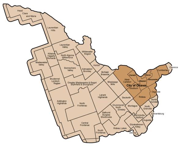
Figure 1: Renfrew
County-Mississippi-Rideau Groundwater Study Area
The goals of the
groundwater study were to:
· map the location of regional
groundwater systems;
· assess their susceptibility to
contamination; and
· characterize the quantity and quality
of the groundwater on a regional scale.
One of the main
functions of the groundwater study was to bring together groundwater
information from various sources such as: Federal and Provincial agencies,
municipalities, health units, conservation authorities and the private sector.
By sharing knowledge on groundwater, surface water, contaminant, agriculture
and population data stakeholders are in a better position to protect public
health and the natural environment.
The groundwater
study was performed in several stages including assessments of groundwater
resources, contamination, usage and a review of management strategies. Tasks
included land use surveys, groundwater sampling program, review of geology
mapping, review of databases on known and potential contaminated sites, review
of water well records, identification of communal groundwater supply systems,
identification of aquifer recharge areas, and mapping of areas where the
aquifer is most susceptible to contamination.
Compiled data
will serve as input for a larger provincial effort to map groundwater
conditions across Ontario. As such the Ministry of the Environment funded 85%
of this $760,000 Study (the remaining 15% was cost shared between the
participating municipalities, with the City contributing $71,000).
The groundwater
study’s results are also being presented to Renfrew County Council on October
29 and Lanark County Council on October 30. These meetings are being
coordinated to emphasize the partnerships that have been formed by this study.
The
recommendations of the groundwater study are consistent with the City of Ottawa’s
Phase 1 Groundwater Management Strategy approved by City Council in May 2003.
Various programs now exist in the City that relate to this study such as the
well inspection pilot program and public education initiatives such as
homeowner workshops for well and on-site wastewater systems. The implementation
process will involve assessing how new initiatives can be integrated with
current programs to improve groundwater protection.
The groundwater
study improves our overall understanding of groundwater resources in Ottawa and
together with previous studies, such as the Eastern Ontario Water Resouces
Management Study (March 2001) and the City-Wide Preliminary Aquifer
Vulnerability Study (April 2001), the City has established a strong foundation
for future groundwater management initiatives.
DISCUSSION
The
intent of this report is to summarize the major findings of the study and
outline the steps required to move forward with implementation tasks.
The results of
the groundwater study were grouped into eight areas: (1) database compilation,
(2) regional water budget, (3) aquifer characterization, (4) surface water
quality, (5) groundwater use, (6) aquifer vulnerability, (7) contaminant
inventory and (8) agricultural impacts.
Generally, it was
found that compiling the data in a geographic information system presented new
opportunities for the sharing of information between partners. The regional
water budget demonstrated that most of the study area is sensitive to a
lowering of water levels in wells during the summer months when rainfall is
infrequent. The majority of the aquifers within the study are capable of
providing good water quality with adequate supply. Some exceptions exist in the
eastern and western portions of the City of Ottawa where groundwater is pumped
from bedrock with significant shale content and often has higher sulphur
content. The surface water quality was scrutinized for phosphorus and ammonia.
Most of the study area has average phosphorus concentrations, however in the City
of Ottawa phosphorus occasionally exceeds provincial objectives at most rural
stream sampling locations.
Groundwater is
used within the study area for potable water, irrigation and livestock watering
and as a source for manufacturing and industry. It is estimated that 2% of the
available groundwater is being removed. There is no indication of depletion on
a regional scale although localized areas suffer from over withdrawal. One of
the key tasks was to identify aquifers that are vulnerable to contamination and
over 90% of the area was found to have high vulnerability because of the
predominance of shallow overburden. The contaminant inventory identified 65
known contaminant sources within the study area. The highest potential concerns
were landfills and auto junkyards. The potential of threats to groundwater from
agricultural activities such as pesticide use was found to be low. Further
details can be found in the attached Summary Report (Document 1).
The primary
recommendation from the study is the creation of the Implementation
Committee. Through this Committee, the
various municipalities and conservation authorities will be able to work
together to develop a cohesive implementation strategy.
The groundwater
study indicated that the main tools available to municipalities for groundwater
protection are the use of regulatory land use planning controls for new
development and the promotion of voluntary measures for existing development
and water users. The recommendations
related to land use planning include:
- incorporating groundwater protection
into planning documents and correlating groundwater records with watershed and
subwatershed plans;
- developing new requirements for small
developments such as minimum lot sizes and mandatory road setbacks;
- requiring approvals for large scale
developments to be based on cumulative impact data and more detailed
hydrogeology studies.
Recommendations
related to best management practices include requiring high risk land uses to
submit groundwater protection plans and greater municipal involvement in
monitoring. Further details can be found in Table 3-1 of the attached Summary
Report.
Prioritizing the
Recommendations
In order to move
forward in conjunction with the study partners, the first step is to receive
direction on the priorities of individual municipalities. With this in mind,
staff is planning a workshop with City of Ottawa Councillors and senior staff
for winter 2004. Workshops will also be held in Renfrew and Lanark Counties.
Following the workshops, the Implementation Committee will categorize
recommendations as short, mid and long term and propose areas to focus upon.
ENVIRONMENTAL IMPLICATIONS
This
groundwater study included a review of existing information related to water
resources and infrastructure servicing and has provided an improved
understanding of water resource issues and concerns. Through implementation of
groundwater study recommendations a net positive impact on water resources will
ensure a sustainable approach to development and growth.
RURAL IMPLICATIONS
Implementation
of groundwater study recommendations will help protect local water resources,
promote the application of standards needed to protect the rural community and
ensure the long-term viability of rural development.
CONSULTATION
Public
consultation was widely promoted throughout the groundwater study. Providing
information to and receiving input from the public was achieved through several
means. A contact list was prepared to
identify key public and private stakeholders – which included government
ministries and agencies, municipal representatives, conservation authorities,
land use and industry associations and public interest groups. A newsletter
presenting the groundwater study’s scope and objectives was issued to the
targeted stakeholders. Three public open houses were held Lanark, Pembroke and
Richmond. The open houses were held to inform the public of the objectives of
the groundwater study and to receive their comments on the groundwater issues
in the study area. The meeting in
Richmond was held on 27 June 2002 and 15 members of the public attended. It was
found that the open houses were poorly attended throughout the study area
although those who attended generally expressed encouragement that the study
was proceeding and were interested in understanding local groundwater
conditions. An additional method of communication was the development of a web
site by the Rideau Valley Conservation Authority’s Landowner’s Resource
Centre. The web site, hosted by the
Mississippi Conservation Authority, provided project updates on the groundwater
study’s progress (www.mvc.on.ca/rmrgroundwaterstudy).
In addition to
the attached Summary Report (Volume 1), there is another detailed document that
contains the technical appendices. This
Volume 2 is currently being printed.
Both documents will be collectively available for public reference at
the following locations:
· The Corporate Resource Centre, 110
Laurier Street
· Kinburn Client Service Centre, 5670
Carp Road
· North Gower Client Service Centre,
2155 Roger Stevens Drive
· Orleans Client Service
Centre, 255 Centrum Boulevard
· University of Ottawa Library, 65
University Street
· Carleton University Library, 1125
Colonel By Drive
· Algonquin College Library, 1385
Woodroffe Avenue
· Ottawa Public Library, Cumberland
Branch, 1599 Tenth Line
· Ottawa Public Library, Richmond
Branch, 6240 Perth Street
FINANCIAL IMPLICATIONS
As
the implementation plan is further developed, a financial analysis of each
element of the plan will be undertaken and this will be reported back to
Committee. Funds are currently available for the next step which is the
planning and development of a workshop to set priorities for the implementation
of the groundwater study’s recommendations. The cost of this workshop is
approximately $5,000 and can be funded from Order No. 900408, Rural Servicing
Strategy.
SUPPORTING DOCUMENTATION
Document
1 - Volume 1: Summary Report, Renfrew County
– Mississippi – Rideau Groundwater Study (September 2003)
DISPOSITION
The
Development Services Department will continue working on implementation and
develop a workshop for winter 2004.
Document 1
VOLUME 1
SUMMARY DOCUMENT
The
Ontario Ministry of the Environment has teamed up with local municipalities,
Counties and related agencies to undertake a groundwater study in the Renfrew
County – Mississippi Valley and Rideau Valley areas. The Study covers an area of approximately 22,000 square
kilometres including the entire Counties of Renfrew and Lanark, North and
Central Frontenac, and Addington Highlands Township, the City of Ottawa and the
balance of the Mississippi and Rideau river watersheds. A map of the study area is shown as Figure 1.
The
goal of the Groundwater Study is to map the location of regional groundwater
systems, assess their susceptibility to contamination and to determine the
quantity and quality of the groundwater within. The study provides recommendations for an updated groundwater
management and protection policy to be considered for implementation by
municipal planning staff within the Study Area. The data will also be used as input into a larger provincial
effort to map groundwater conditions across Ontario.
One
of the main functions of the study is to bring the scattered pieces of
groundwater information relevant to the Study Area together. Several groups
including municipalities, Health Units, Conservation Authorities and provincial
agencies each have portions of the information that, when compiled and
interpreted, provide the groundwater “big picture”. By investigating and sharing groundwater knowledge, stakeholders
will be in a better position to understand the groundwater resources and their
use, and protect public health and the natural environment
The
study was performed in several stages including: a Groundwater Resource
Assessment, a Groundwater Contamination Assessment, a Groundwater Use
Assessment and the undertaking of a Groundwater Management Strategy. The study involved the completion of land
use surveys, review of geology mapping, review of databases on known and
potentially contaminated sites, review of water well records, inventory of
communal groundwater supply systems, identification of aquifer recharge areas,
and mapping of areas where the aquifer is most susceptible to contamination.
The
study was financed in large measure (85%) by the Ontario Ministry of the
Environment through its Operation Clean Water Program. It is part of the $10 million provincial
effort in 2002 to better understand the province’s groundwater resources. The remaining 15% was provided by the following
eight partners:
·
Addington Highlands Township
·
Central Frontenac Township
·
City of Ottawa
·
Lanark County
·
Mississippi Valley Conservation Authority
·
North Frontenac Township
·
Renfrew County
·
Rideau Valley Conservation Authority
The principal
goals of the study are, at a regional scale:
1)
to develop a database and Geographic Information System that can be
used in the future by municipalities and Conservation Authorities to maintain
data on the groundwater resources within the Study Area and to aid in future
analysis, interpretation and management of these resources;
2)
to undertake a regional water balance to map the interrelationship
between precipitation, surface water runoff and groundwater infiltration that
can be used in future watershed analyses as well as to estimate potential
replenishment of the groundwater resources;
3)
to map the location of significant groundwater aquifers, and
groundwater recharging/discharging areas, and to understand the groundwater
flow system and quality conditions within such systems;
4) to assess, on a
regional scale, the surface water quality conditions;
5)
to inventory the major groundwater users within the Study Area and to
assess whether aquifers, on a regional scale, can be expected to meet the
groundwater demand;
6)
to map areas where the aquifers are susceptible to contamination;
7)
to identify known and potential contaminant sources that could possibly
affect the quality of groundwater; and,
8)8) to inventory
existing municipal, provincial and federal policies, guidelines and regulations
that protect groundwater, and to identify various groundwater management
strategies that the participating municipalities and Conservation Authorities
can implement to enhance management and protection of groundwater resources
within the Study Area.
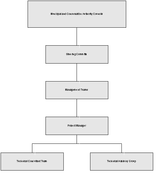
1.4 Project Organization
The organizational structure of the project is presented in the figure
below.
The organizational structure of the project is presented in the
figure below.
Mississippi
Valley Conservation Authority (MVCA), on behalf of Municipal and Conservation
Authority Councils, administered the study.
Reporting to the Councils was a Steering Committee made up from members
of the participating municipalities and Conservation Authorities that
controlled the overall direction of the study and program objectives. A Management Team made up of representatives
of MVCA, RVCA, the City of Ottawa and Renfrew County controlled the day-to-day
operations of the project, and appointed an external project manager to direct
the Technical Consultant Team. A
Technical Advisory Group, made up individuals specialized in technical
disciplines was appointed to provide input to the Management Team on technical
issues relating to the methodologies of the Consultant Team.
Acknowledgements
The
successful completion of this study was the result of the invaluable
contribution of many study partners including the Management Team, the Steering
Committee, and the Technical Advisory Group.
These individuals provided guidance and advice throughout the study. The members of the committees are listed
below.
Management Team
Michael Renaud,
Project Manager (MHPM Project Managers Inc.)
Paul Lehman,
(Mississippi Valley Conservation Authority)
Brian Stratton
(City of Ottawa)
Charles Cheesman
(County of Renfrew)
Dell Hallett
(Rideau Valley Conservation Authority)
Steering Committee Members
Paul Lehman
(Mississippi Valley Conservation Authority)
Councillor Janet
Stavinga (City of Ottawa)
Brian Stratton
(City of Ottawa)
Dell Hallett
(Rideau Valley Conservation Authority)
Phil Sweetnam
(Mississippi Valley Conservation Authority)
Charles
Cheesman (County of Renfrew)
Mayor Raye-Anne
Briscoe (Renfrew County Council Representative)
Sylvia Coburn
(Lanark County)
Robert Harvey
(Township of Central Frontenac)
Ibra Cuddy
(Township of Addington Highlands)
Technical Advisory Group
John Price
(Mississippi Valley Conservation Authority)
Kerry Carnegie
(Ontario Ministry of Agriculture and Food)
Bob Putzlocher
(Ontario Ministry of the Environment)
Heather Wilson
(Consultant)
Jacques Sauriol
(Consultant to the City of Ottawa)
Ian Jarvis
(Agriculture and Agri-food Canada)
Paul Moreau
(Ontario Ministry of Natural Resources)
Dr. Robert
Bélanger (Geological Survey of Canada)
Dr. Michel Robin
(University of Ottawa)
Henry Garcia
(Lanark, Leeds & Grenville County Health Unit)
Jean-Guy Albert
(City of Ottawa Health Department)
Bob Schreader
(Renfrew County Health Unit)
Asher Rizvi
(Rideau Valley Conservation Authority)
Consultant Team
Golder Associates
Ltd.
Paul Smolkin,
P.Eng, Project Manager
Dillon Consulting
Limited
Darin Burr, M.Sc, Project Co-ordinator
J.L. Richards
& Associates Limited
Tim Chadder,
Planning Groundwater Management Approaches
Agricultural
Watershed Associates
Dr. Richard
Coote, Agricultural Assessment
A
Public Communications Plan was designed to inform the public about the
groundwater study and to receive their input regarding groundwater management
and protection issues. In particular,
the public was consulted to help with the following:
·
Identifying and incorporating local knowledge and information into the
study;
·
Increasing community awareness of the importance of groundwater as a
resource; and,
·
Ensuring that stakeholders have a say in recommendations for
groundwater protection measures.
Providing
information to, and receiving input from the public was gained through several
means. A Contact List was prepared with
input from the Management Team and Steering Committee identifying key public
and private stakeholders who would have an interest in groundwater
protection. Stakeholders identified on
the Contact List included government ministries and agencies, municipal
representatives, Conservation Authorities, land use and industry associations
and public interest groups. A
newsletter presenting the study’s scope and objectives was issued to the
targeted stakeholders. A public open
house was held in June 2002 in Lanark, Pembroke and Richmond to inform the
public of the objectives of the study and to receive their comments on the
groundwater issues in the Study Area.
An additional method of communication was the development of a study web
site by the Rideau Valley Conservation Authority’s Landowner’s Resource
Centre. The web site (www.mvc.on.ca/rmrgroundwaterstudy),
hosted by the Mississippi Conservation Authority provided project updates
during the study’s progress.
The Public
Communications Plan is an ongoing initiative that will facilitate the
presentation of the groundwater study results and inform the public about the
options for groundwater management.
Future activities of the Public Communications Plan may involve
promotion of educational events tailored towards groundwater protection, development
of topic-specific information newsletters, and release of groundwater
information through the local media.
The
results of the components that comprise the Groundwater Study assessment are
detailed in separate appendices that are contained within Volume 2 of the
report. Volume 1 of the report, that
is presented herein, summarizes the major findings of the investigation and
outlines a groundwater management strategy that can be used by the
participating stakeholders. A database
of all recommendations made in this study has been prepared and is printed in
Appendix 1.
Various
data sources were used throughout the groundwater management study to derive
the results that have been presented as maps, figures, tables and summary
statistics throughout the study. Since
much of this data is being continually expanded and updated over time as new
information becomes available, the project was designed so that the data used
in the project could be easily accessed and updated.
To
accomplish this task, and to facilitate data analysis, all
the data collected during this assignment were managed in a Geographic
Information System (GIS) environment.
The GIS system allows the user of the data to quickly access, review and
update the information as needed. The
GIS system also allows future analysis of the data through the production of
summary statistics, mapping and querying.
The GIS also enables information to be placed into the digital database
that describes the source and accuracy of the data. This information is often referred to as “Metadata”, and allows
the end user to quickly determine the source of the information that has been
used in any analysis, and allows the user to then determine the level of accuracy
or completeness of the information shown.
The electronic database compiled during this study is provided as a
project deliverable, as per the Terms of Reference.
For this study, all information that was either provided by
external partners, agencies or contractors or derived during this study was
input into a GIS environment using ArcView 8.2 software. This GIS environment is common to all the
regional groundwater studies in Ontario and will allow future common sharing of
data between the municipalities, Conservation Authorities or other agencies.
An important part of
this study was to perform a regional water budget to assess the
interrelationship between precipitation, surface water flow and groundwater infiltration. The purpose of completing the water budget
was to:
·
estimate
by subwatershed, the amount of water that infiltrates the ground to potentially
recharge the aquifers; and
·
identify
watersheds where baseflow (groundwater) may provide a substantial component of
flow to the surface water system.
The water balance is
relevant to the Groundwater Study in several ways. Firstly, it maps areas on a regional scale where infiltration is
likely highest. Land use in these areas
may have a greater risk of impacting recharging groundwater that may flow
towards shallow wells or become baseflow in streams. Secondly, it maps areas that contribute the most to baseflow, and
highlights areas where the development of impervious surfaces may reduce the
baseflow component. Together this
information can be used to help assess both potential quality and quantity
impacts to surface water and the shallow aquifer resources.
A summary of the
major findings is presented below.
Precipitation and
Infiltration
Precipitation in the Study Area
averages 875 mm per year; however the amount varies considerably across the
Study Area. Precipitation is lowest in
the Ottawa Valley between Arnprior and Chalk River (<850 mm), and higher in the
east over the Ottawa, Brockville and Cornwall areas (>975 mm). Of the average 875 mm of precipitation that
falls in the Study Area, approximately 60% of the moisture is returned to the
atmosphere through evaporation or by transpiration through vegetation.
Approximately 12% runs directly to the streams and 28% infiltrates the ground
to become groundwater. The infiltrating
water recharges aquifers and provides baseflow to streams.
Areas of highest groundwater
infiltration were identified in regions of shallow lying bedrock or areas where
the soil is sandy. For example, the
fractured flat lying limestone/dolostone aquifers that are found in the eastern
portion of Lanark County, United Counties of Leeds and Grenville and
southwestern portion of the City of Ottawa are mapped as high infiltration areas. Similarly, areas where sandy soils are
present (e.g., Petawawa, Deep River, Kemptville – Osgoode – Ottawa area) are
mapped as regions of high infiltration.
In areas where sandy soil is underlain by clay, much of the infiltration
will likely be directed to surface water rather than recharge deep aquifers.
Drought and Seasonal Effects
Most infiltration to the groundwater
occurs during the late spring to early summer, with a second period of
significant infiltration occurring in late fall. Infiltration during the spring and early summer produces both
baseflow to the streams and deep percolation flow (recharge) to
groundwater. Baseflow from groundwater
is very important during summer droughts, as it is often the only flow in the
streams.
During the summer months when rainfall is infrequent,
the reduction in groundwater recharge can result in seasonal problems of
reduced well pumping yields. Most of
the Study Area is sensitive to these conditions as the majority of wells pump
from regionally unconfined fractured bedrock or sand and gravel aquifers.
The severity of the problem will depend on many
conditions including the depth of well, the permeability of the aquifer and the
depth of the well pump. Properties
serviced by shallow dug wells or sand points are found in areas of Ottawa and
Renfrew County; they will have the most problems because well depths do not
usually exceed 10 metres. The problems also tend to be more significant in
aquifer recharge areas where the water table is naturally lower than in
discharge points. In the Study Area,
lowering of water levels within wells is usually a seasonal problem, and water
levels soon replenish themselves with the fall rains. However, if a long-term trend of decreasing precipitation
develops, seasonal water shortage problems will likely become more frequent and
severe.
One
of the fundamental purposes of this study was to characterize the groundwater
aquifer conditions. An assessment of
groundwater flow was performed through a review of geology and groundwater
sampling reports, water sampling, and an analysis of the MOE water well
records. The specific objectives of
this investigation included:
·
identifying key regional aquifers and aquitards, and mapping their
distribution;
·
mapping the direction and magnitude of groundwater flow in the
aquifers;
·
identifying areas of discharge to surface water, and
·
assessing the groundwater quality.
A
summary of the major findings is presented below.
Aquifer Locations
Most
of the aquifers within the Study Area are capable of providing good quality
water with adequate supply. The
majority (93%) of the wells tap bedrock aquifers while 7% pump from overburden
aquifers. While some aquifers have
higher average yields than others, all aquifers are generally capable of
supplying adequate yields for residential use on private services (<13
litres/minute or 3 Igpm).
Bedrock
aquifers make up the largest proportion of pumped aquifers in the Study
Area. Within the Counties of Renfrew,
Lanark, Lennox and Addington, and Frontenac Precambrian rock
(igneous/metamorphic rock) is the main aquifer. Sandstone, limestone and dolostone aquifers are important in the
eastern portions of Lanark County and through much of the Ottawa area. Aquifers composed of intermixed limestone
and shale are present in the east and west ends of Ottawa. Groundwater flow through bedrock aquifers
occurs along fractures. Vertical
fractures predominate in the Precambrian aquifers that underlie a large western
part of the Study Area, while horizontal fractures and horizontal bedding
planes are more common in the sedimentary rock in the east. Because fractures near the ground surface
provide a direct path for surface water to enter the subsurface, bedrock aquifers
are often susceptible to potential contamination, especially in areas where the
overburden cover is thin.
While
bedrock provides the main source of groundwater in the Study Area, some of the
bedrock aquifers are better than others.
The Sandstone Aquifer, located in the eastern portion of the Study Area
in Lanark, Leeds and Grenville and the City of Ottawa, provides the best water
in terms of quantity and quality, and is often the aquifer of choice when
drilling large capacity wells. The
Dolostone Aquifer is the most used by individual residents because of its large
aerial extent in populated areas and good water quality. Aquifers that contain significant amounts
of shale often have poor water quality; however, they are pumped in the east
and west ends of Ottawa, as better aquifers are too deep to be economically
drilled. The Precambrian aquifer has
the largest aerial extent and has acceptable water quality; however,
groundwater yields within such aquifers can sometimes be marginal.
Significant
overburden aquifers exist around Petawawa, southern portions of the City of
Ottawa, and locally throughout Renfrew County.
Glacial till can also act as an aquifer where the clay content is low
and the sand and gravel content is high.
In many situations, drillers target the contact zone between the
overburden and the bedrock where sand and gravel is present and the top portion
of the bedrock is fractured. Overburden
aquifers, where they are not covered by clay, are often unconfined and
therefore not well protected from sources of contamination at the surface. The overburden aquifers are generally
underutilized, and could be a future water supply.
Groundwater Flow
Groundwater
flow is controlled largely by differences in elevation. It generally moves from high to low land
elevations. In the northern and eastern
portions of the Study Area (over much of Renfrew, Ottawa and Lanark),
groundwater flow is northwards towards the Ottawa River, while in the west (in
Lennox and Addington, and Frontenac), it is more southward towards the St.
Lawrence River. Regional groundwater
flow in the Study Area appears to generally follow the regional run-off
drainage patterns.
Deviations
from the regional groundwater flow directions often occur at the local
scale. These changes, in a large part,
are caused by variable land elevations that encourages the development of
small-scale groundwater recharge/discharge conditions that are somewhat
independent of regional flow patterns. As a result, prediction of shallow
groundwater flow patterns, and therefore potential contamination pathways in
these areas, is more difficult.
The
study shows that replenishment of groundwater to the aquifers through recharge
occurs throughout the Study Area, however regional recharge conditions appear to
be more prevalent in some areas than others.
Mapping of groundwater recharge conditions indicate that significant
regional recharge areas exist in the highlands of Renfrew County, Addington
Highlands and North Frontenac Townships.
This recharge will replenish both local aquifers as well as aquifers to
the east that are shielded from infiltration by overlying clays.
Local
scale recharge areas exist throughout the entire region, and are generally
associated with areas of higher elevation.
Esker-like overburden deposits located in Renfrew and Ottawa may act as
a local source of recharge for bedrock aquifers.
Groundwater and Surface Water
Interaction
Groundwater
is an important contribution of water to surface water features, in that
groundwater discharge, or baseflow, provides most of the water to streams
during the summer and winter months.
Mapping shows that potential
discharge areas exist in most topographically depressed areas such as ravines
and river valleys. For example, the
ravines and streams that exist throughout the western portion of Renfrew
County, Addington Highlands Township, North and Central Frontenac Townships,
and the western and northern portion of Lanark County are identified as
potential discharge areas. In the
Rideau Valley watershed and the eastern portion of the Mississippi Valley
watershed, many of the wetland areas are identified as potential discharge
areas. Wide areas of potential
groundwater discharge appear along the eastward side of the Madawawska
Highlands, the Bonnechere valley, the Madawaska River and the Carp River. Many of the lakes in the western portions of
the Study Area have been identified as cold water lakes, and likely receive
significant baseflow from the surrounding local recharge areas.
Water Quality
The natural quality of the groundwater in the Study
Area is generally good. Some exceptions
exist in the eastern and western portions of the City of Ottawa, where
groundwater is pumped from bedrock with significant shale content. The presence of shale within an aquifer
often results in elevated concentrations of hydrogen sulphide. Hard water is
common in the eastern portions of Lanark, the City of Ottawa and Leeds and
Grenville, and in portions of the Ottawa Valley in Renfrew, where groundwater
is produced from limestone rock.
Groundwater having lower hardness concentrations is most common in the
western portions of the Study Area in Precambrian rock aquifers (in Renfrew
County, Addington Highlands, the western portion of Lanark County and North and
Central Frontenac Townships). The
presence of sodium at concentrations in excess of the recommended advisory
limit (Ontario Drinking Water Standard) for those on salt restricted diets is
naturally common in the Study Area.
The most common water quality problems
within the Study Area result from chloride and nitrate contamination. In some areas chloride can be naturally
elevated, either due to the presence of marine clays or because the groundwater
is old and has been within the subsurface flow system for a long time. Groundwater with moderate to high chloride
concentrations was found in many bedrock and overburden aquifers. The highest chloride concentrations were
associated with shallow wells. Man-made
sources of chloride (and sodium) include road de-icers, water softeners and
septic systems. Road de-icing would
likely be the most significant chloride source in the Study Area.
Elevated nitrate concentrations are
also present in some areas. Nitrate
contamination is most frequently caused by septic systems. Both nitrate and chloride impacts to
groundwater are often found in areas where the bedrock is shallow.
Assessment of the surface water
quality conditions in the Study Area was performed by reviewing surface water
quality data at 23 Provincial Water Quality Monitoring Network (PWQMN) Stations for the period between 1997
and 2001. The purpose of the assessment was to:
·
evaluate
the quality of water at a regional level; and,
·
determine
if there is a relationship between surface water impacts and groundwater
quality concerns.
Two groundwater contaminants,
ammonia and phosphorus, were scrutinized with respect to potential degradation
of surface water. The sources of phosphorus or ammonia to surface water systems
are often from either inadequately designed or maintained septic systems, or
from agricultural run-off. These
chemicals are also introduced into surface water from effluent discharges from
municipal sewage treatment plants.
Average concentrations of total
phosphorous, and total ammonia during the assessment period indicate that the
water quality at the 23 PWQMN stations is generally good. However, results indicate that total
phosphorous concentrations in the Clyde River and in the Mississippi River (particularly
at Almonte) are elevated and of potential concern. Results also indicate that concentrations of total ammonia are
not a concern at PWQMN stations, however, historical data shows that the total
ammonia concentration at the Kemptville Creek station is occasionally somewhat
elevated.
Average water quality data indicates
relatively few exceedances of total phosphorous in Lanark County streams and
lakes, however, maximum total exceedances of the Provincial Water Quality
Objectives are common. Average total
phosphorous concentrations were observed to be above the provincial objectives
in Mississippi Lake. Grants Creek,
Rudsdale Creek, Black Lake, Davern Lake, Otty Lake, Pike Lake and Rainbow Lake
(all in Lanark County) were also observed to be occasionally elevated in
concentrations of total phosphorous.
On an average basis, total
phosphorus occasionally exceeds provincial objectives at most of the City of
Ottawa rural stream sampling locations.
The highest total phosphorous concentrations occur in the Taylor Drain,
the Monahan Drain, and a ditch in the Village of Cumberland. The water quality in these drains and
ditches themselves may not be a significant concern, although potential impacts
on downstream receiving water bodies may warrant assessment.
Average total ammonia concentrations
did not exceed provincial objectives at any of the City of Ottawa rural surface
water sampling locations; however, maximum total ammonia concentrations
exceeded the provincial objectives on at least one occasion in Ramsay Creek, in
the Carp River, and in an unnamed Creek in the Village of Richmond. These exceedances may be of concern if
sensitive aquatic life inhabits these surface water bodies.
Chloride concentration data
indicates that the Carp River, the Monahan Drain, Harwood Creek, Ramsay Creek,
Green Creek, Borthwick Creek, Coady Creek and Bear Brook Creek are likely
impacted by man-made sources of chloride (run-off), and thus may also be
susceptible to other types of surface water contamination.
On a regional level, there is no
indication that discharging contaminated groundwater is adversely impacting
surface water quality. Although there
are likely specific source locations where impacted groundwater discharges are
causing more local adverse effects, no specific examples were identified. Impacts to surface water from groundwater
impacts are expected to be most prevalent in the Ottawa Valley area of Renfrew
County, City of Ottawa, and eastern Lanark County where agricultural activities
and residential development along water is most prevalent. The trend towards converting cottage
properties to all-season homes and the increase in tiling of agricultural
fields will likely increase the degree of this problem.
Within
the Study Area, groundwater is a major source of water for domestic,
commercial, agricultural and ecological activities. Groundwater is used as a potable water source to municipalities
and private homes, for irrigation and livestock watering and as source of water
for manufacturing and industry.
Groundwater also has an important role in sustaining natural ecological
habitats by maintaining baseflow to surface water and wetlands.
The
purpose of this task was to gain an understanding of the current and future
demands on the groundwater supply, determine if the aquifers can be reasonably
expected to maintain these demands at the subwatershed level, and identify
large groundwater users whose systems are regulated under the Ontario Water
Resources Act.
Specific
objectives of this investigation included:
·
Identifying the major groundwater users and the annual volumes;
·
Determining whether the groundwater supply can be reasonably expected
to meet future groundwater demands; and
·
Inventorying regulated water users whose systems fall under O.Reg.
459/00 (large water systems, e.g., municipal water systems) and O.Reg. 505/01
(water systems that supply sensitive populations, e.g., schools, daycares,
hospitals, seniors residences, etc.).
A
summary of the findings is as follows:
Water Use
The
total volume of groundwater used in the Study Area by public, private and
commercial activities is approximately 59,000 Mega litres (ML) per year, of
which 23% is required for potable water purposes. Commercial/institutional uses account for 38%, irrigation for
15%, livestock watering for 4%, commercial/industrial manufacturing for 3%,
mining for 11%, and other uses (such as remediation by pumping) for 6%.
While
the majority of the people in the Study Area rely on surface water as their
potable water source, 199,000 or 21% of the total Study Area population of
933,000 use the groundwater as a potable source of water. Of this population, 185,000 get their water
from private wells while the remainder are serviced by municipal wells. Ottawa has the highest number of residents
on private wells (75,000) of any municipality, but the lowest percentage of
residents on groundwater (10%). The
Townships of Addington Highlands and North and Central Frontenac rely solely on
private wells for their potable water supply.
In the County of Lanark, 61% of the residents rely on groundwater, while
in the County of Renfrew 46% use groundwater as their potable water
supply. The estimated total volume of
groundwater used for potable purposes is 14,000 ML/year.
Municipally
owned and operated groundwater supply systems are present at 10 locations,
namely Killaloe, Haley Townsite, Beachburg, Almonte, Carp, Kings Park
Subdivision in Richmond, Munster, Kemptville, Merrickville, and Westport. An eleventh system, Carleton Lodge, supplies
a community home of 200 people in Ottawa.
The total population served by groundwater source municipal systems is
14,000. The maximum volume of water
pumped by these systems is estimated to be 6,000 ML/year.
An
inventory of communal well systems identified 114 potential and 18 known O.Reg.
459/00 systems and 269 potential O.Reg 505/01 systems.
Large Water Users
Large water users are registered in
the province of Ontario through the Permit to Take Water system that registers
water takings that exceed 50,000 L/day.
The study identified 134 permitted takings of water in excess of 50,000
L/day, of which 90 were in excess of 200,000 L/day. The largest permitted takings are from the quarries and aggregate
industry (32,000 ML/year); however, much of this water (up to 80%) is
anticipated to come from surface water.
The largest permitted groundwater takings are from golf courses and
groundwater source heat pumps; once again the actual taking is expected to be
less than the permitted rate.
Aquifer Capability and
Future Demand
An evaluation of whether groundwater
resources are sustainable or depleting was made by comparing the quantity of
groundwater pumped to the estimated volume of infiltration that replenishes the
aquifers.
Overall, it is estimated that the
total volume of groundwater taken is <2% of what is potentially available
from recharge. Based on this
comparison, there is no indication of depletion in groundwater resources on a
regional or subwatershed scale. Localized
areas of aquifer mining or interference caused by overwithdrawal likely occur,
however these problems are localized and do not reflect widespread problems (no
specific locations were identified).
Ecological Uses
In
addition to the use of groundwater for potable, commercial, agricultural and
industrial uses, groundwater has an important role in maintaining ecological
habitats such as cold water streams, wetlands and natural habitats. Baseflow during summer months when
precipitation is low is especially important as it maintains water levels that
are needed for habitat and vegetation.
Groundwater baseflow also improves surface water quality as it
assimilates surface water contaminants, and helps supply water to forests.
Areas of potential significant
baseflow were identified by mapping groundwater discharge areas. Many of the wetland areas are identified as
potential discharge areas as are the lakes and rivers in the western portions
of the Study Area.
One
of the key tasks of the project was to identify areas where the aquifers are
vulnerable or susceptible to contamination.
Land use managers can use this information to protect groundwater
susceptible resources by diverting potentially harmful land uses from areas of
high vulnerability. The specific
objectives of this evaluation included:
·
Identifying aquifer vulnerability of the various aquifer systems, and
identifying any differences between the systems; and
·
Assessing the level of confidence in the calculated aquifer
vulnerability maps.
The
main data used as input into the vulnerability mapping was depth of watertable,
and the thickness and permeability of soil or rock material overlying it. Areas where the aquifer is not overlain by
low permeability materials, or where the watertable is shallow, were identified
as having higher aquifer vulnerability.
In general, the MOE approach is used to describe the vulnerability of
the “first” aquifer encountered from ground surface, and is therefore most
suitable to assessing the vulnerability of an aquifer from a near surface
source of contamination.
Location of Vulnerable
Aquifers
Over
90% of the Study Area is mapped as high vulnerability because of the
predominance of shallow overburden. The
thin soils provide minimal protection to underlying bedrock aquifers. Where overburden aquifers exist, they are
often not protected by overlying low permeability material such as clays or
silts. The fact that the water bearing
zones are often at depth in the bedrock has the effect of reducing the actual
vulnerability to some degree, provided the well is properly constructed. If the well casing is not properly sealed,
the well is vulnerable to contamination from surface or near-surface sources.
Areas
of low to moderate vulnerability are most predominant in flat lying areas that
have clay or silt deposits. The largest
areas of low to moderate vulnerability are in the Ottawa Valley in Renfrew
County and the City of Ottawa. Smaller
areas of low to moderate vulnerability are scattered throughout the Study Area,
and are attributed to localized accumulations of clay soil.
In
some areas, protected aquifers exist at depth but are overlain by more
vulnerable aquifers at surface. These
areas may be better suited for residential development on private services
where there is separation or isolation between the potable water aquifer at
depth that is pumped, and the surface aquifer that receives, for example,
septic system discharges.
Uncertainty
Estimation of aquifer vulnerability is not an
exact science, as many of the variables that affect these estimates such as the
presence of fractures, thickness of protective layers, and direction and
magnitude of groundwater flow are difficult to ascertain based on the rather
coarse level of data available for this study.
As a result, the aquifer vulnerability maps produced in this evaluation
are best used as a guidance tool for land use planners, and cannot be used on
their own to make site-specific land use decisions. Nevertheless, they can be used to direct efforts in selecting
regions for more detailed analysis.
Considering the high level of uncertainty in
the aquifer vulnerability map, an analysis was undertaken to map the level of
confidence that can be put into the map.
The results of this analysis indicated that in areas where clay is very
thick such as in the Ottawa Valley, and for which a considerable amount of well
data exists, there is a high probability that any underlying aquifer would be
protected. Similarly, any area where
there is thin overburden or for which the density of well data is low, would be
classified as having a high probability of being highly vulnerable.
2.7 Contaminant Inventory
(Appendix G)
Locations of potential current and
future environmental risk were identified through an inventory of known and
potential contaminant sources. For each
location, a low, medium or high environmental risk factor was assigned
depending upon the type of contaminant, whether or not the site had been
remediated and the vulnerability of the aquifer(s) at/around the site.
The potential sources of
contamination that may be of concern within the Study Area can be generally
described as:
·
point
sources (i.e. localized sources such as existing and former landfills,
underground storage tanks, road salt storage and application, chemical plants,
etc.); and
·
non-point
sources (i.e. sources which are more widely distributed such as agriculture pesticide and fertilizer use ).
Information
on potential contaminant sources was collected from a number of data sources,
including Ministry of the Environment (MOE) files and databases, private
databases, the Federal contaminated sites and solid waste landfills inventory,
and interviews with municipal staff.
The Study did not reveal large scale groundwater problems within the
Study Area, but rather more localized situations associated with a specific
source. A summary of the results,
broken down into three categories, is presented below.
Potential Contaminant
Sources Based on Land Use
Land uses that were identified as
the highest potential concern were abandoned landfills and auto junkyards. Active landfill sites, or those that have
been active during the past 15 to 20 years are not considered to pose as high a
risk to groundwater users since there have been hydrogeological studies and
monitoring programs undertaken to define the extent and degree of groundwater
impacts. Sewage treatment plants were
also identified as a potential concern because of impacts to surface water from
their effluent discharges. Land uses
that were identified as having low to moderate risk included manufacturers and
retail facilities, located in low aquifer vulnerability areas.
Within the Ottawa urban area, most
of the current manufacturing activity is classed as low risk, as it is mostly
comprised of printing and related support activities. Wholesale of equipment and hardware and manufacturing of
fabricated metal products were also found to be relatively significant sectors
within the Ottawa urban area, and generally not an immediate concern. Manufacturing of metal and wood products
comprised the greatest proportion of manufacturing sectors beyond the Ottawa
urban area.
Contaminant Sources Based on
Historic Records
A review of historical records of
chemical spills indicates that 50% of the concerns were related to domestic and
commercial heating oil releases that could have had the potential to affect
groundwater.
The next highest quantity of spills
(20%) comprised motor vehicle accidents in which gasoline or diesel and/or
other vehicle fluids such as ethylene glycol were released. The remaining
records consisted primarily of relatively small-scale miscellaneous petroleum
spills.
With respect to spill locations,
approximately 50% of all significant spills took place in urban areas within
Ottawa, and therefore impact to potable groundwater resources is reduced.
Known Contaminant Sources
Based on the MOE and Federal
records, and municipal survey responses, 65 significant, known contaminant
sources were identified within the Study Area.
The largest proportion of known sources comprised those involving
storage, handling and/or disposal of petroleum hydrocarbons and/or chlorinated
solvents associated with dry cleaning and metal degreasing operations. The Study identified five known
aquifer-scale contaminant plumes associated with solvent releases among these
65 identified sources. Leachate impact
from landfills encompassed the second greatest proportion of known sources.
Of the 65 sites, 31 are located within
serviced areas of their respective municipalities, and hence represent less of
a concern in terms of potential impacts to aquifers that are actively used for
water supply purposes. However, they
remain a concern from a groundwater management perspective.
Other Contaminant Sources
One
of the classes of point source contamination that could not be mapped due to a
lack of addressed (geo-referenced) data was fuel storage tanks. These are, however, known to be pervasive
throughout the Study Area and can generally be assumed to be present at all
gasoline service stations, facilities where commercial vehicle fleets are
based, and bulk terminals. Such storage
tanks are also utilized for waste oil storage at vehicle repair and maintenance
facilities, for heating oil storage at residences and other facilities, at
heating plants, and at sites with emergency generators. Any storage area of fuels or petroleum
products is considered to be of high concern, especially in areas where the
aquifer is vulnerable. Historic outdoor
road salt storage and ongoing road salt applications also represent a source of
contaminants that could lead to well and aquifer quality degradation.
Another
broad category of contaminant sources that was not mapped is communal and
private septic systems. These
contaminant sources are prevalent within non-serviced rural areas, and pose the
greatest concern where soils are thin; such is the case in most portions of the
Study Area. Septic systems can
typically result in individual well contamination problems and, in more
vulnerable areas, to a gradual decline in aquifer water quality.
As a
potential source of contamination to groundwater, agriculture has been
implicated as contributing to elevated nitrate and bacteria concentrations in
many regions of the world. Less clear
is the extent of groundwater contamination by pesticides used on agricultural
land. With this in mind, an assessment of whether or not agriculture is likely
a major contributor to groundwater quality impairment in the Study Area was
conducted. Specific objectives
included:
·
examining the potential for agricultural pesticide use to contaminate
groundwater;
·
determining the extent to which nitrogen used in agricultural
production may cause elevated groundwater nitrate concentrations; and
·
estimating
the risk of micro-biological contamination of wells in the Study Area posed by
livestock production.
The
potential of agricultural land to contaminate groundwater in the Study Area was
assessed by comparing areas of agricultural use with aquifer
vulnerability. A summary of the study
findings is presented below.
Risk from Pesticide Impacts
Pesticides are most commonly used on croplands,
which in the Study Area are located in the clay belts of the Ottawa and Rideau
River Valleys. Because these areas have
a low to moderate vulnerability, the risk to aquifers from contamination is
low. Furthermore, most of the pesticides
are in the form of herbicides, which are generally of less concern to water
quality than other pesticides. In
agricultural areas where the aquifer vulnerability is high, the land is used
mainly for hay and pasture, where pesticide and fertilizer use is minimal. Exceptions have been noted in four small
areas where pesticide use may be occurring on agricultural land overlying
vulnerable aquifers. However, in the
absence of known pesticide contamination of groundwater in the Study Area,
there does not appear to be cause for major concern about this potential source
of contamination. As more land with
high aquifer vulnerability is converted from hay and pasture to cultivated
crops, the potential for contamination of groundwater by pesticides can be
expected to increase.
Risk of Nitrogen Impacts
Agriculture introduces nitrate into the groundwater
through the use of fertilizers, manure, and the growing of leguminous
crops. A review of agricultural data
indicates that the amount of nitrogen that is applied to the soil is on average
lower in the Study Area than for Ontario as a whole. Most of the farmlands that were identified as having higher
nitrate leaching potentials were found mostly in low to moderately vulnerable
areas.
No
correlation between the locations of wells with elevated nitrate levels and the
locations of agricultural activities was observed.
Risk of Bacterial
Impacts
Microorganism
contamination of well water, often by bacteria from livestock manure, is a
major public concern. Within the Study Area, livestock densities are greatest
in the flat lying clay belts, where the aquifer vulnerability is low to
moderate. Wells that are placed in
shallow aquifers are the most at risk.
There
are few large livestock operations in the Study Area. Two in each of Goulbourn
and Rideau wards of the City of Ottawa appear to be above average in size and
are in areas with high aquifer vulnerability.
Large operations do not necessarily pose a greater threat to groundwater
than small operations, as they are often well managed.