7.
ZONING – 1100 OLD CARP ROAD ZONAGE – 1100, CHEMIN OLD
CARP |
COMMITTEE RECOMMENDATIONS AS
AMENDED
That Council
approve an amendment to Zoning By-law 74-79 of the former City of Kanata to
re-zone the lands situated at 1100 Old Carp Road from Estate Residential (ER),
to Institutional (I), Open Space - Special Exception 1 (OS-1), Residential Type
1B - Special Exception 3 (R1B-3), Residential Type 1B - Special Exception 5
(R1B-5), Residential Type 3A (R3A), Residential Type 3A – Special Exception 2
(R3A-2), and Residential Type 3A – Special Exception 3 (R3A-3) as shown on
Document 2, subject to the following amendments:
1. That
staff be directed to bring forward two separate implementing Zoning By-laws for
this application, one for the new school site and adjoining townhouse parcel to
the east (required for servicing) and one for the balance of the parcel.
2. Whereas the
rural residents of Old Carp Road were promised a buffer between rural and urban
through the lengthy planning process for the Kanata North Urban Expansion;
Resolved
that the “Buffering and Landscaped Open Space” of 6.3 metres be amended to require
restorative replanting and reforesting (to the satisfaction of the City) if
existing vegetation is destroyed during the development process; and,
Further
that the subdivision agreement include mechanisms to protect the 6.3 metres no-build strip in
perpetuity.
3. That the
Zoning be amended to reinstate the seven lots on Street 6 subject to
commensurate Open Space being contributed by the landowner elsewhere in the
area to the City’s satisfaction.
4. And that no
further notice be given pursuant to Section 34 (17) of the Planning Act.
RECOMMANDATIONS MODIFIÉES DU COMITÉ
Que le Conseil municipal approuve une
modification au Règlement municipal de zonage 74-79 de l’ancienne Ville de
Kanata en vue de modifier le zonage des terrains situés au 1100, chemin Old
Carp, de zone de domaines résidentiels (ER) à zone d’institutions (I), à zone
spéciale d’aire ouverte – exception 1 (OS-1), à zone spéciale résidentielle de
type 1B – exception 3 (R1B-3), à zone spéciale résidentielle de type 1B –
exception 5 (R1B-5), à zone résidentielle de type 3A (R3A), à zone spéciale
résidentielle de type 3A – exception 2 (R3A-2) et à zone spéciale résidentielle
de type 3A – exception 3 (R3A-3) comme le précise le document 2, sous
réserve des modifications suivantes :
1. Que le personnel présente deux règlements de zonage de mise en œuvre
distincts pour cette demande, un pour l’emplacement de la nouvelle école et la
parcelle adjacente de maisons en rangée à l’est (nécessaire pour la
viabilisation), et un pour le reste de la parcelle de terrain.
2. Attendu qu’on a promis aux résidants
du secteur rural du chemin Old Carp une zone tampon entre les milieux rural et
urbain dans le cadre du long processus de planification pour l’expansion
urbaine de Kanata Nord.
Il est résolu que la disposition relative à la zone tampon et à l’aire
ouverte de 6,3 mètres est modifiée afin d’exiger la plantation et le
reboisement (à la satisfaction de la Ville) si la végétation existante est
détruite au cours du processus d’aménagement.
Il est en outre résolu que l’accord de lotissement comprendra des
mécanismes visant à protéger la bande sans construction de 6,3 mètres de
façon permanente.
3. Que le zonage soit modifié de façon
à rétablir les sept lots de la rue 6, à condition que l’aire ouverte
correspondante soit aménagée par le propriétaire à un autre endroit dans la
zone, à la satisfaction de la Ville.
4. Et qu’aucun autre avis ne soit émis
en vertu de la section 34 (17) de la Loi sur l’aménagement du territoire.
Documentation
1. Development Services Department General Manager’s report dated 12 May 2003 (ACS2003-DEV-APR-0121).
2. Extract of Draft Minutes, 22 May 2003.
Report to/Rapport
au:
Planning and
Development Committee /
Comité de l’urbanisme et de l’aménagement
and Council/et au Conseil
12 May 2003 / le 12 mai 2003
Submitted by/Soumis par: Ned Lathrop, General Manager/Directeur général
Development Services Department
/ Services d’aménagement
Contact/Personne-ressource: Grant Lindsay, Manager, Development
Approvals / Gestionnaire, Approbation des demandes d’aménagement
580-2424 ext.
13242, grant.lindsay@ottawa.ca
|
Ref N°: ACS2003-DEV-APR-0121 |
SUBJECT: ZONING
- 1100 OLD CARP ROAD
OBJET: ZONAGE – 1100, CHEMIN OLD CARP
REPORT
RECOMMENDATION
That the
Planning and Development Committee recommend Council approve an amendment to
Zoning By-law 74-79 of the former City of Kanata to re-zone the lands situated
at 1100 Old Carp Road from Estate Residential (ER), to Institutional (I), Open
Space - Special Exception 1 (OS-1), Residential Type 1B - Special Exception 3
(R1B-3), Residential Type 1B - Special Exception 5 (R1B-5), Residential Type 3A
(R3A), Residential Type 3A – Special Exception 2 (R3A-2), and Residential Type
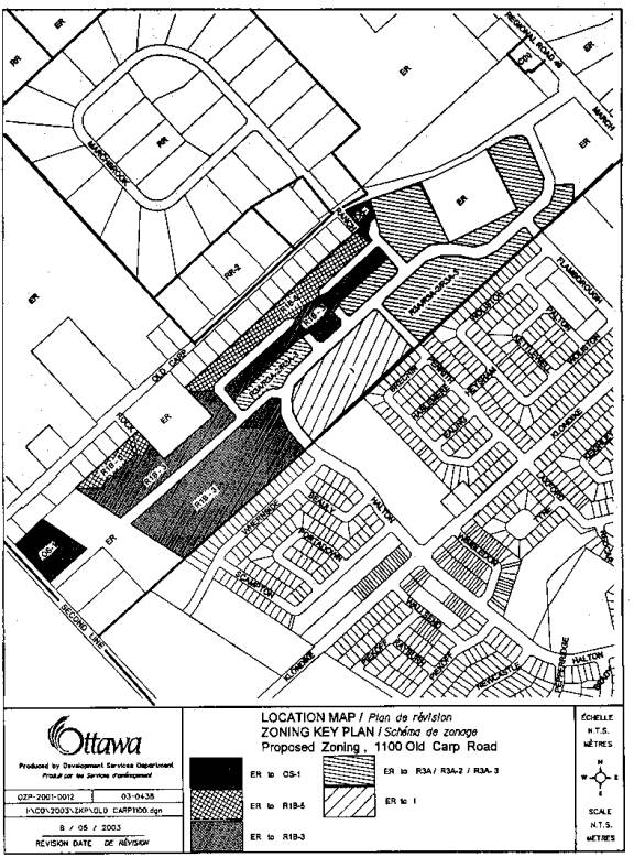
3A – Special Exception 3 (R3A-3) as shown on Document 2.
RECOMMANDATION DU RAPPORT
Que le Comité de l’urbanisme et de
l’aménagement recommande au Conseil municipal d’approuver une modification au
Règlement municipal de zonage 74-79 de l’ancienne Ville de Kanata en vue de
modifier le zonage des terrains situés au 1100, chemin Old Carp, de zone de
domaines résidentiels (ER) à zone d’institutions (I), à zone spéciale d’aire
ouverte – exception 1 (OS-1), à zone spéciale résidentielle de type 1B –
exception 3 (R1B-3), à zone spéciale résidentielle de type 1B – exception 5
(R1B-5), à zone résidentielle de type 3A (R3A), à zone spéciale résidentielle
de type 3A – exception 2 (R3A-2) et à zone spéciale résidentielle de type 3A –
exception 3 (R3A-3) comme le précise le document 2.
BACKGROUND
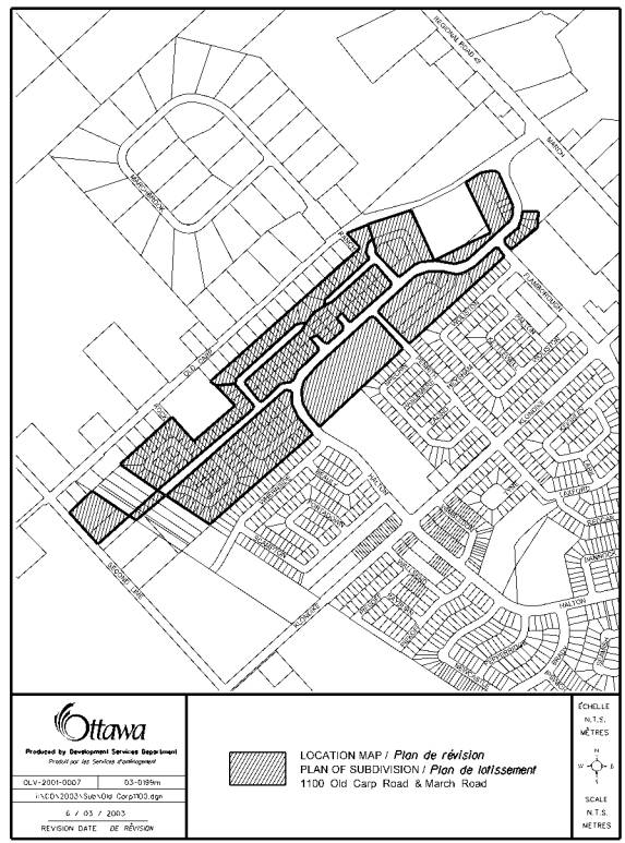
The subject lands consist of 29.5 hectares in the northern most portion of the South March Community and form part of a residential development known as Morgan’s Grant.
The area is bounded by the northern limit of the Kanata North Expansion Area, the existing Morgan’s Grant Community to the south, March Road to the east and Second Line Road to the west (see Document 1). The Hydro Corridor cuts through the subject lands in a south-easterly direction near the western edge. The proponent has submitted development plans on all of the land holdings within the South March Community, with the subject lands being one of the final parcels needing approval (Phase 12).
The subject lands are designated “Kanata North Expansion Area” in the former Regional Official Plan and are designated “General Urban Area” in the recently adopted City of Ottawa Official Plan. Within the “General Urban Area”, all types of residential densities, parks and natural areas and institutional uses are allowed.
The lands are designated “Low Density Residential” and “Open Space” in the former City of Kanata’s Official Plan. Permitted uses within the Residential designation include fully detached, semi-detached and multiply attached dwelling units.
The property is currently zoned “Estate Residential” (ER) by the March Rural Zoning By-law (74-79). Permitted uses in this zone include fully detached units and various agricultural uses. Although residential uses are permitted under the current zoning, the provisions and standards pertain to developments within a rural setting. The proposed amendment reflects that these lands are now within the urban area of the City and will be developed on full municipal services.
DISCUSSION
The proposed amendment reflects that these lands are now within the urban area of the City and will be developed to urban densities. The lands are proposed to be re-zoned to a “Residential Type 1B - Special Exception 3”, (R1B-3), “Residential Type 1B - Special Exception 5” (R1B-5), “Residential Type 3A” (R3A), “Residential Type 3A – Special Exception 2” (R3A-2), and “Residential Type 3A – Special Exception 3” (R3A-3). One parcel will be zoned “Institutional” for a public elementary school and 3 parcels will be zoned “Open Space” for park purposes (see Document 2).
Staff, the applicant and the community have participated in extensive discussions regarding the development of this phase. Of particular concern is the requirement for the school site. The Ottawa-Carleton District School Board is in urgent need of a site in order to have a new school serving the Community for the fall of 2004. In order for this to occur, planning approvals must be in place as soon as possible.
There has also been extensive communications with the residents of this area, in particular, the residents of Old Carp Road. When the urban boundary was extended to its current location through ROPA 8 and LOPA 58, there were significant concerns raised by these residents about having a buffer between the urban and rural lands.
The City of Kanata approved LOPA No. 58 on November 9, 2000. This amendment established the definition of “Buffers” as it relates to the rural residences south of Old Carp Road. It states:
A
buffer for the northern edge of the Urban Residential Area bordering onto the
back of properties in the Rural Area fronting on the south side of Old Carp
Road and for the northern edge of the Urban Restricted Industrial Area east of
march Road is required.
This buffer can take many forms including, but not limited to, extra lot depth with landscaping and fencing, a pedestrian/cycling path, a linear park, a watercourse or drainage channel or a passive open area. The form and extent of the buffer can vary with its location and shall be determined at the time of the plan of subdivision of the area containing the rural/urban buffer. Generally, the buffer located west of March Road should be wider to accommodate existing tree cover where possible.
These buffers for rural/urban separation may also be provided in the zoning by-law.
On May 10 2001, the new City of Ottawa considered LOPA 58. Planning and Development Committee recommended that Council recommend that the Ministry of Municipal Affairs and Housing approve the amendment with modifications. One of the modifications was: “ No trees will be cut down on lands within 20 metres of the rear lot lines of the homes on Old Carp Road until the approval of a Plan of Subdivision application which will address landscaping and buffering issues.”
However, that same day Minto acknowledged in a memo to the March Rural Association and City staff that tree cutting in this area had already begun and that it may have extended within the 20 metres referred to by Council.
The Ministry of Municipal Affairs and Housing approved LOPA No. 58 of the City of Kanata on October 30, 2001. This approval included a modification that exactly reflected the motion passed by Council of the City of Ottawa.
On April 23, 2003, the City Forester undertook a preliminary assessment of the status of the remaining trees along the rear lot lines of the homes on Old Carp Road. He was unable to walk the site since permission to enter the land had not been received, but his observation was that there appeared to be less than 20 metres of trees left abutting these properties.
City staff have had extensive discussions with Minto on ways to achieve the buffer. They include: deeper lots for the properties abutting those on Old Carp Road, retaining the remaining tree cover to the extent possible given servicing and grading constraints and the viability of the remaining trees, covenants on title and restricting development in the rear yards of these lots. If all of these measures are implemented, staff are satisfied that an effective buffer between the rural and urban lands can be achieved.
The pedestrian/cycling path, linear park and passive open area options as types of buffers were also examined. It was determined that this was not the most appropriate location for the parkland dedication requirements. The dedication to the City of a long linear corridor of open space between the existing properties on Old Carp Road and the new subdivision would have limited benefit to the community at large. Concern was also expressed about the impacts of a pathway adjacent to the Old Carp Road properties.
The Open Space block at the western edge of the subject lands is also a matter of discussion. Staff are recommending that this parkland block be enlarged, as shown on Document 2, encompassing the adjacent 7 single lots, fronting onto the street that intersects with Second Line Road. This would enable a larger portion of the woodland to be preserved as an entrance feature and/or a passive park parcel into the subdivision. This area was identified as a high quality representative Forest area and is proximate to the South March Highlands Wetland Complex. Staff are recommending the removal of these lots to enlarge the park block based on environmental, community design and supply of required open space objectives. The amount of parkland that needs to be dedicated to the City in terms of Planning Act requirements would easily accommodate this enlargement.
ENVIRONMENTAL IMPLICATIONS
The western portion of this property is within 120 metres of the South March Highlands Wetlands Complex, a Provincially Significant Wetland complex. In order to address this area of Provincial interest, a Wetland Impact Study was prepared. The recommendations of this study as they apply to Phase 12, will be implemented through the Plan of Subdivision process.
A Tree Conservation Plan was also prepared as part of this proposal. The Plan noted a significant stand of trees in the area proposed to be re-zoned OS-1. Staff’s proposal to enlarge the area would support and enhance this woodland feature.
RURAL IMPLICATIONS
Residents on Old Carp Road have noted water quality and quantity regarding existing wells as a concern. City staff, in accordance with a council motion passed in May 2001, are investigating this matter. The outcome of this investigation will be available prior to the consideration of a subdivision for these lands in accordance with Council’s direction.
CONSULTATION
The Ward Councillor is aware of this application and the South March and the March Rural Community Associations were notified. Further, this application was discussed at public meetings held on the following dates: June 13, 2001, 26 June 2001, October 25, 2001 and April 9, 2003.
The residents’ concerns and the staff response are outlined in Document 4.
FINANCIAL IMPLICATIONS
N/A
APPLICATION PROCESS TIMELINE
STATUS
This application was not processed within the recommended timelines. It was placed on hold until the accompanying plan subdivision was revised and recirculated to include a school site and respond to comments received on the initial circulation.
ATTACHMENTS
Document 1– Location Plan
Document 2 – Zoning Map
Document 3 – Details of Proposed Zoning
Document 4 – Consultation
DISPOSITION
Department of Corporate Services,
Secretariat Services
to notify the owner Minto Developments Inc. c/o Marcel Dénommé, 427 Laurier
Avenue West, Suite 300, Ottawa, ON K1R
7Y2, and the Manager of Assessment,
Department of Corporate Services of City Council’s decision.
Development Services Department to prepare the implementing by-law,
forward to Legal Services Branch and undertake the statutory notification.
Department of Corporate Services,
Legal Services Branch
to forward the implementing by-law to City Council.
LOCATION PLAN Document
1
ZONING MAP Document
2
DETAILS OF PROPOSED ZONING Document
3
Proposed Residential Type 1B – Special Exception 5 (R1B-5) Zone
ZONE PROVISIONS:
|
lot area |
330.0 square metres |
|
lot frontage |
11.0 metres |
|
front yard depth |
4.5 metres |
|
rear yard depth |
6.0 metres |
|
buffering and
landscaped open space |
Notwithstanding the provisions of Section 3(3)(a) and 3(3)(b), no buildings or structures, with the exception of fences shall be permitted within 6.3 metres from the rear lot line. |
CONSULTATION Document 4
Residents have expressed concerns with buffer zone, the school site, well water safety, appropriate zoning of the lands, and transportation, particularly with the intersections of the internal roads with March Road. Most of these issues were addressed in the report. The remaining issues are discussed below.
Zoning: The residents are concerned that densities other than those required by fully detached homes will be permitted on lots abutting the properties fronting on Old Carp Road. With the approval of these zones as proposed and Minto’s ambitious development timeframe, this issue should be adequately addressed.
Transportation: The residents are concerned with the impacts of increased traffic at the intersections of Old Carp Road and March Road and Klondike Road and March Road. This issue can be addressed through the subdivision process as conditions of approval.
Drainage: They are also concerned with drainage from the properties on Old Carp Road onto Minto’s lands. The residents have experienced flooding in the past. The drainage issues will be addressed as part of the subdivision process.