ANNEX B
1.
trail road and nepean landfill sites 2001 annual
monitoring report décharges contrôlées
du chemin trail et de nepean – rapport du programme annuel de contrôle de
2001 |
Committee Recommendation
That Council receive this report for information.
Recommandation du comité
Que le Conseil prenne
connaissance de ce rapport à titre d’information.
Documentation
1.
Transportation,
Utilities and Public Works, General Manager’s report dated 10 October 2002
is immediately attached (ACS2002-TUP-UTL-0030).
2.
A draft Extract
of Minutes of 26
November 2002 immediately follows the report and includes the voting record.
Report to/Rapport au:
Comité des services de l’environnement
And Council/et au Conseil
10 October 2002/le 10 octobre 2002)
Submitted by/Soumis par: R.T. Leclair, General Manager/Directrice générale
Transportation, Utilities and Public Works/Transport, services et travaux publics
Contact/Personne-ressource: P. McNally, Director/Directeur
Utility Services Branch/Direction
des services publics
Telephone No.: (613) 580-2424, extension 22609
e-mail: Patrick.McNally@ottawa.ca
|
|
Ref N°: ACS2001-TUP-UTL-0030 |
SUBJECT: TRAIL
ROAD AND NEPEAN LANDFILL SITES -
2001 ANNUAL MONITORING REPORT
OBJET: DÉCHARGES CONTRÔLÉES DU CHEMIN TRAIL ET DE
NEPEAN – RAPPORT DU PROGRAMME ANNUEL DE CONTRÔLE DE 2001
REPORT RECOMMENDATION
That the Environmental Services
Committee recommend Council receive this report for information.
Que le Comité
des services de l'environnement recommande au Conseil municipal de prendre
connaissance de ce rapport à titre d'information.
In accordance with the terms and conditions of the conditional Certificate of Approval No. A 461301 for the Nepean Landfill site, and the conditional Certificate of Approval No. A 461303 for the Trail Road Landfill site, the City of Ottawa must submit an annual site progress and monitoring report to the Ontario Ministry of the Environment (MOE).
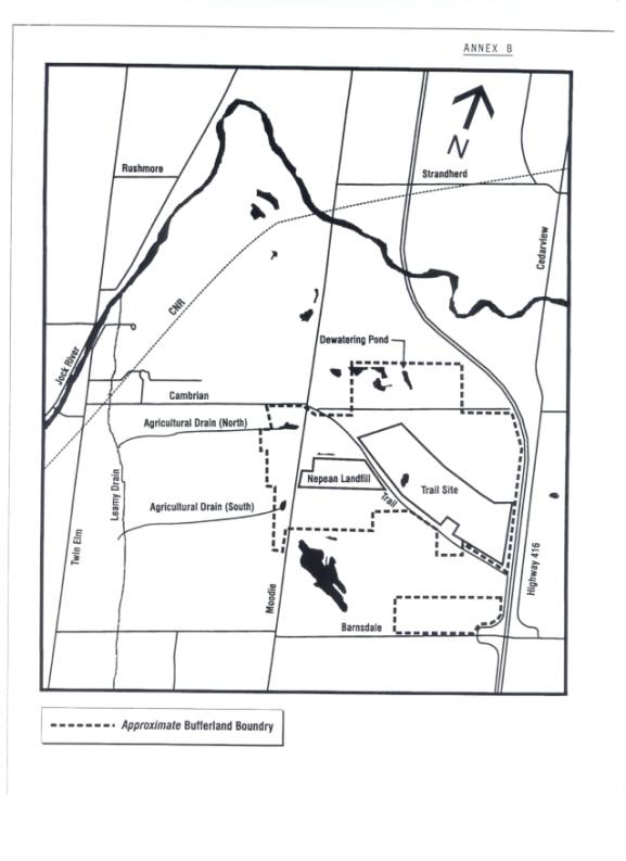
The report for the 2001 Monitoring and Operating Program was submitted to the MOE in May 2002. The purpose of this report is to provide information on the environmental and operational status of both the Trail Road Landfill and the closed Nepean Landfill sites as outlined in the report to the Ministry of the Environment. Submission of the Annual Monitoring report to the Ministry is a requirement of both certificates of approval. A copy of the Executive Summary as prepared by Golder Associates is attached as Annex A. A reference map of the sites and surrounding areas is attached as Annex B.
DISCUSSION
The Trail Road and Nepean landfill sites are in compliance with the terms and conditions of their respective certificates of approval issued by the Province of Ontario. The 2001 monitoring and operating program report describes the monitoring, operating, and capital development activities at the Trail Road and Nepean landfill sites during 2001. The main elements of the monitoring program look at the groundwater impacts, surface water impacts and any impacts of landfill gas migration.
The groundwater monitoring program documents leachate influence in the aquifers related to the site. Two principal overburdened aquifers, one shallow and one deep, are identified at the Trail and Nepean landfill sites. It is important to note that linear groundwater velocity in the vicinity of both landfill sites is generally estimated to be in the order of several centimetres to an upper range of several tens of metres per year, respectively in the shallow and deep aquifers. Stages 3 and 4 of the Trail Road facility are designed with synthetic bottom liners to prevent leachate impacts. The monitoring program is intended to confirm the performance of the liners.
Surface water monitoring tests the creeks, streams, agricultural drains, and springs around the sites to monitor landfill impacts. The landfill gas program ensures the gas generation during the decomposition of the waste is being appropriately handled and does not cause a threat to the operators or the public.
The Nepean Landfill site began receiving waste in the early nineteen sixties. It no longer receives waste and is closed. The site was re-graded in 1991 to promote surface water run off, and capping was completed in 1993. The final landscaping was completed in 1994.
The groundwater flow pattern is similar to that of previous years. The deep aquifer flows north towards the dewatering pond in the bufferland north of the Trail Waste Facility. The shallow aquifer flows south and west to spring-fed ponds in the bufferland. Leachate migration in the deep aquifer extends beneath the northwest corner of the Trail Waste Landfill property and is measured in the bottom portion of the aquifer. Leachate effects from the Nepean Landfill in the shallow aquifer occur west just beyond Moodie Drive and to the south.
The surface water, in the upper reaches of the agricultural drain immediately west of Moodie Drive, exceeds the Provincial Water Quality Objectives (PWQO) for unionized ammonia (ammonium), boron, iron and total phosphorous. However, farther along the agricultural drain, prior to discharge to the Leamy Drain, all provincial surface water quality objectives are met. Sampling in 2001 indicated the presence of volatile organic compounds in the upper reaches of the agricultural drain immediately west of Moodie Drive. Concentrations of these parameters are less than the PWQO criteria. These compounds are not detected farther along the drain, prior to discharge to the Leamy Drain. The surface water quality southwest of the Nepean Landfill continues to exhibit minor leachate effects but water quality remains within livestock drinking water criteria.
Surface waters flow from the spring-fed ponds to the west, and from the dewatering pond to the north through a series of agricultural drains and eventually to the Jock River. The absence of leachate indicator parameters indicates that the Jock River water quality remains unaffected by surface water discharges from the closed Nepean Landfill site.
Landfill gas migration is controlled by an active gas extraction system installed in 1993. The landfill gas is processed at the gas flaring station at the Trail Waste Facility.
As a precaution against landfill effects, water from the water supply wells on adjacent private properties is no longer used for consumption. Bottled water continues to be supplied. The acquisition of additional bufferland and implementation of a remedial action plan as required by the MOE are underway as part of the regulatory closure plan. Over the years, several property acquisitions have been completed. The remaining properties are under negotiation.
Trail Road Landfill Site
The groundwater flow pattern is similar to that of previous years. The deep aquifer flows towards the dewatering pond in the bufferland north of the Trail Road Landfill site. Leachate migration effects, from Stages 1 and 2, in the deep aquifer from the Trail Road Landfill site, are directly beneath the landfill. The shallow aquifer flows northeast and discharges in the forested bufferland north of the filling area on the regional clay plain. Leachate effects in these areas are completely contained within the boundary of the site.
The surface waters from the dewatering pond and the springs in the bufferland forest, which flow north through agricultural and roadside ditches and eventually to the Jock River, meet PWQO at the site boundaries. The water quality of the Jock River remains unaffected by surface water discharges from the Trail Road Landfill site.
In 1991, the landfill gas control system was switched from a passive venting system to an active gas extraction system that flares the gas at the flaring station. The active landfill gas extraction and flaring system continues to reduce greenhouse gas emissions. Landfill gas migration patterns are similar to that of previous years with movement south into an area where additional bufferland was acquired. The landfill gas collection system was expanded in 1998 to include Stage 3 of the landfill site. A series of gas collection wells was installed into the refuse and modifications to the existing leachate underdrain collection system were made to allow for the collection of landfill gas generated in Stage 3 of the Trail Waste Landfill site.
Several residential water supply wells near the landfill sites were tested at the owners’ request. No leachate indicators were found in any of the wells.
The Trail Road Landfill site received 260,676 tonnes of waste in 2001, of which 153,541 tonnes were landfilled. It is estimated that the site will reach approved capacity by 2008/2009.
A permanent composting facility has been in operation on the bufferland north of the Trail Waste Landfill site since 1994. In 2001, 23,238 tonnes of residential leaf and yard material and brush, 554 tonnes of commercial leaf and yard material, and 520 tonnes of Christmas trees were received at the permanent composting facility. In 2000, 26,565 tonnes of residential leaf and yard waste were received at the composting facility, and an additional 617 tonnes of commercial leaf and yard waste and 452 tonnes of Christmas trees were received. Compost is sampled prior to leaving the site to ensure that MOE requirements are met. All of the compost produced in 2001 met the MOE requirements.
During its operation from 14 April to 15 December 2001, the permanent Household Special Waste Depot accepted material from 12,246 vehicles. In 2000, material was received from 10,873 vehicles.
Capital and Operating Projects
The following projects were initiated or completed in 2001:
· a poplar tree leachate remediation project was initiated;
· an Ontario Municipal Board hearing on the preferred leachate pipeline route was held;
· the leachate treatment research pilot studies continued;
· a study on the long-term use of the Trail Waste Landfill through the site Optimization/Expansion Environmental Assessment continued;
· the landfill gas microturbine pilot project at the flaring station continued;
· construction of a permanent H-flume to measure discharge from the Dewatering Pond was completed; and,
· a new compactor and bulldozer were procured.
Finally, the report recommends adjustments to the monitoring programs that are summarized in the Executive Summary attached as Annex A.
The public consultation process is not applicable. A copy of the final report for the 2001 Monitoring and Operating Program for the Trail Waste Facility and the Nepean Landfill sites have been filed with the City of Ottawa’s Secretariat Services Branch, Corporate Services Department. Copies will also be available at three branches of the Ottawa Public Library, at the two local libraries located at Centrepoint and the Walter Baker Centre, and also in the Ottawa Room of the Main Branch at Metcalfe and Albert streets. Quarterly meetings are held with the local MOE office to discuss operations at the Trail Waste Facility and, although not specific to the annual monitoring report, there was considerable contact and dialogue with the public regarding issues related to the proposed routing for a leachate pipeline and the treatment and handling of contaminated groundwater and leachate as well as the Optimization/Expansion Environmental Assessment.
FINANCIAL IMPLICATIONS
The monitoring program and subsequent report were prepared through a contract for 2001 with Golder Associates Limited. Funds for the contract are budgeted for annually in the Solid Waste Services Division's Operating Budget. The contract with the consultant is reviewed annually, and will end in December 2002.
Annex A - Trail Road and Nepean Landfill sites report for the 2001 Monitoring and Operating Program – Executive Summary.
Annex B - Reference map for the Trail Road and Nepean landfill sites and surrounding property.
ANNEX A
EXECUTIVE
SUMMARY
The following Executive Summary highlights only key points from the report. For complete information and findings, as well as the limitations provided in Section 9.0, it is necessary for the reader to examine the complete report and previous reports.
The City of Ottawa (City) owns both the Trail and Nepean Landfill Sites. The City is responsible for the environmental maintenance of the Nepean Landfill and operates the Trail Landfill. The Trail Landfill receives non-hazardous solid waste from most of the City of Ottawa.
The Nepean Landfill has not received municipal solid waste since 1980. The Nepean Landfill received final cover in 1993 incorporating an engineered geomembrane hydraulic barrier cap and active landfill gas collection system.
The Trail Landfill has operated since 1980 to receive municipal solid waste. The Trail Landfill is divided into distinct stages of operation. Stages 1 and 2 were designed based on a natural attenuation landfill. These stages were covered in 1988 and 1991, respectively, with a low permeability geomembrane cap to reduce leachate generation through infiltration. Stages 3 and 4, the approved final stages of the Trail Landfill, were both designed based on engineered containment and have a composite bottom liner (clay and geomembrane) and leachate collection system. Landfilling in 2001 took place in Stages 3 and 4, with the majority of waste being placed in Stage 4. Landfill gas is controlled at the site through an active gas collection system and flaring station for all capped stages, Stage 3 and the closed Nepean Landfill. A groundwater and surface water monitoring program documents changes in groundwater and surface water quality and determines how they are being influenced by the landfill sites.
OPERATIONS
Gross waste received in 2001 was 260,676 tonnes. The net amount of waste landfilled was 153,541 tonnes. Waste diverted from the landfill was 24,521 tonnes. Fill material (82,614 tonnes) was received on-site for daily and interim waste cover, dykes, roads and side slope work, and makes up the balance of the gross waste tonnage. Approximately 40,638 tonnes of material was used for daily landfill cover in 2001.
As of November 2001, the combined remaining theoretical air space in Stages 3 and 4 for disposal (including waste, daily cover material and final cover material) is approximately 1,833,890 cubic metres. Based on the projections of the space consumption, the theoretical completion date for Stage 3 and 4 is late 2008.
During 2001, the following major activities
and capital works projects were undertaken by the City at the Trail Landfill:
· A poplar tree remediation pilot project was initiated;
· An Ontario Municipal Board hearing on the preferred leachate pipeline route was held (awaiting ruling);
· The leachate treatment research pilot studies continued;
· A study on the long term use of the Trail Landfill through the Site Optimization/Expansion Environmental Assessment continued;
· The landfill gas microturbine pilot project at the flaring station continued;
· Construction of a permanent H-flume to measure discharge from the Dewatering Pond was completed; and
·
A
new compactor and bulldozer were procured.
During 2001, the Trail Landfill operated in compliance with its Provisional Certificate of Approval.
There were no operations ongoing at the Nepean Landfill during 2001. During 2001, the following capital works projects were undertaken by the City at the Nepean Landfill:
· A poplar tree remediation pilot project was initiated; and
·
Ongoing
design of the groundwater collector/subdrain to intercept groundwater moving
onto properties located immediately south and southwest of the Nepean Landfill.
During 2001, the Nepean Landfill was in compliance with its Provisional Certificate of Approval.
Leachate influence on groundwater is assessed on the basis of: 1) a physical hydrogeology approach that addresses the flow path and rate of groundwater moving in the groundwater system; and 2) a chemical hydrogeology approach that addresses the alteration of groundwater quality by leachate influences. These two approaches must be combined to provide conclusive scientific evidence of influence of landfill leachate. This methodology was used to determine how surface water and groundwater quality are influenced by the landfill sites.
In the assessment of landfill influence, the study area was subdivided into discussion areas for the surface water and groundwater monitoring locations. The surface water discussion areas are shown on Figures 3.19, 3.20 and 3.21. The groundwater discussion areas are shown on Figure 3.13.
Two principal overburden aquifers, one shallow and one deep, are identified at the Trail and Nepean Landfill Sites. The latter is further subdivided into upper and lower parts. The groundwater monitoring program documents leachate influence in these aquifers.
Careful review of monitoring data and spatial analysis has shown that bromide and to some degree boron are key parameters in the assessment of leachate influences at the sites. In the absence of boron and bromide, and together with the physical hydrogeological interpretation, elevated chloride, alkalinity, iron, hardness, organic carbon and nitrogen compounds in much of the groundwater near Trail and Nepean Landfills are attributed to non-landfill sources. These include fertilizer, road salting (dust control and de-icing) and septic systems, as well as changes in recharge conditions due to landscaping/land use changes leading to a change in mineral dissolution. Organic carbon in much of the groundwater near the Trail Landfill is attributed to elevated organic content of subsurface materials.
Linear groundwater flow velocity in the vicinity of both landfill sites is estimated to be in the order of several centimetres to an upper range of several tens of metres per year, respectively in the shallow and deep aquifers. Localized higher linear velocities of groundwater flow may occur due to increased horizontal gradients and/or hydraulic conductivity brought about by topography and geology.
The
Nepean Landfill has existed since about 1960 or 41 years, whereas Trail
Landfill Stages 1 and 2 have existed since about 1980 and 1987 or 21 and 14
years, respectively. The Nepean
Landfill and Stages 1 and 2 of the Trail Landfill do not have engineered bottom
containment. The estimated groundwater
velocity, together with the age of the landfills, provides an indication of the
maximum distance which leachate could have migrated in the groundwater beyond
the waste. Therefore, under similar
hydrogeologic conditions, leachate influences from the Nepean Landfill would
have migrated farther than those from Stages 1 and 2 of the Trail Landfill.
The natural attenuation stages of the Trail Landfill (Stages 1 and 2) influence groundwater quality in the shallow and deep aquifer. Leachate influence on the shallow aquifer extends a limited distance north of Stages 1 and 2 and is entirely contained on City property, as the shallow aquifer pinches out to the north on City property. Surface water discharge from the property to the northeast does not show any evidence of leachate. Leachate effects on the deep aquifer from the Trail Landfill exist immediately beneath Stages 1 and 2 (in the upper portion of the deep aquifer) in the area where the shallow aquifer does not exist and a limited distance north of Stage 3. Dilute leachate effects may also be present immediately south of Stages 1 and 2 of the Trail Landfill in the vicinity of monitor M34-1 in the upper part of the deep aquifer. Interpretation of groundwater flow information suggests that the maximum extent of leachate effects from the Trail Landfill in the deep aquifer is also somewhere beneath the lined stages of the Trail Landfill. The chemical interpretation is consistent with the physical hydrogeology flow patterns and linear flow velocities. Water quality in other areas of the deep aquifer have elevated key parameters that are not necessarily attributed to the landfill site. These areas are on City property and are included in the ongoing monitoring program.
Because the influence of landfill leachate on groundwater from the Trail Landfill is located within the property boundaries, the site is operating in compliance with the MOE Reasonable Use Guideline B-7.
Leachate effects from Nepean Landfill occur in the shallow aquifer to the west beyond Moodie Drive and also to the south. The shallow aquifer pinches out on the clay plain west of Moodie Drive and the groundwater discharges to the surface water system at this location.
Concentrations of unionized ammonia (ammonium), boron, iron and total phosphorus in excess of Provincial Water Quality Objectives (PWQO) were measured at the headwaters of the surface water system west of Moodie Drive and prior to discharge to the Leamy Drain. As in previous years, some volatile organic compounds were encountered in this surface water system. These volatile organic compounds are no longer detectable prior to discharge into Leamy Drain. This surface water system is a series of agricultural ditches connected to Leamy Drain that discharges to the Jock River. Surface water in the Leamy Drain has increased concentrations of inorganic dissolved constituents along its flow path. A large component of this increase is attributed to agricultural practices, and a component of inorganic constituents is from the Nepean Landfill. The combined sum of chemical loading from the landfill and agricultural practices does not result in exceedance of the PWQO in Leamy Drain for parameters attributed to the landfill.
No effects of leachate from the Nepean Landfill are measured in the deep aquifer at monitoring locations to the west or south of the landfill. Leachate effects exist to the north and northeast of the Nepean Landfill in the deep aquifer and extend beneath the northwest corner of the Trail Landfill property. These effects are measured in the upper, middle and bottom portion of the deep aquifer.
Dilute
leachate effects at monitoring well M40 (situated just north of Stage 4) in the
upper deep aquifer have been measured since 1994. Based on the groundwater flow velocity and time frame of
landfilling, the measured leachate influence is likely from the Nepean
Landfill. Effects at BH12 and M83 and
possible effects at M77, M92 and M123 attributed to leachate from the Nepean
Landfill indicate the plume front from the Nepean Landfill may have passed
these monitoring locations. The
chemical interpretation is consistent with the physical hydrogeology flow
patterns and the estimated range of linear flow velocities.
Landfill gas generation from the Trail and Nepean Landfill Sites continues as in previous years. Landfill gas levels continue to be elevated along Trail Road south of Stages 1 and 2. However, the only structure in that area is on City property and is equipped with methane gas alarms.
Dewatering Pond
It is interpreted that landfill leachate
effects have not reached the Dewatering Pond in either the shallow or deep
aquifer systems. Although there are
upward vertical hydraulic gradients from the bedrock to the basal portion of
the deep aquifer, there are negligible vertical gradients between the lower and
upper portions of the deep aquifer in the vicinity of the Dewatering Pond. Horizontal gradients indicate the Dewatering
Pond area to be a groundwater/discharge feature for the deep aquifer locally.
Shallow groundwater discharges at the southeast corner and outlet of the Dewatering Pond result in distinct iron-staining, sheen, and vegetation growth. The sheen was sampled and chemically analyzed for VOCs. Sufficiently low concentrations of VOCs together with field observations indicate the sheen is not organic in origin. An iron rich groundwater plume in the upper near-surface deep aquifer originating from a fill pile on the Dewatering Pond property is the likely source (Golder, 1999). Iron concentrations exceeded the PWQO for 2001 in the outlet from the Dewatering Pond. The concentrations were comparable to values measured in recent years. VOCs were detected in the discharge stream of the Dewatering Pond at S13 and S51 at concentrations below the PWQO (where PWQO criteria exist). The landfills are not considered to be the source of these VOCs.
The discharges from the Trail and Nepean Landfill Sites do not influence the quality of surface water in the Jock River.
KEY RECOMMENDATIONS
Annual groundwater sampling and water level measurements in April are recommended at selected groundwater monitors. Exceptions to this monitoring frequency are presented in the proposed groundwater monitoring program as presented in Appendix N of this report.
Since 1999 the monitoring of VOCs at the Trail and Nepean Landfill sites has been useful in determining absence or presence of leachate impacted groundwater, determining the origin of leachate impacted groundwater, and in the monitoring of leachate movement. The focus of the VOC monitoring program should be altered to provide greater monitoring of the leading edge of the plume. The revised VOC monitoring program is presented in Appendix N.
As in the past, leachate effects are present on the
property south of the Nepean Landfill at groundwater monitor GR7-1 in
2001. Consideration should be given to
the installation of additional groundwater monitors south of GR7-1 to further define
historical leachate migration south of the Nepean Landfill.
In light of possible leachate effects originating from the Nepean Landfill north of Cambrian Road, monitoring wells installed at borehole location M123 should be monitored three times annually. Monitoring of nearby groundwater monitors M83 and M85; monitors in the direction toward the Dewatering Pond (M62-1, M63-1, and M92-1); surface water ponds north of Cambrian Road and the nearby monitoring location M60 should be continued three times annually.
Increased
parameter concentrations observed at monitor BH16-1 in the upper deep aquifer
since late 1998 require further definition.
Groundwater monitors installed at borehole locations M124 and M125
should be monitored three times annually.
Monitoring of groundwater monitors at BH16A-1, O-1, P-1, M58-1, M107-1,
M124 and M125 should be continued three times annually.
Noting that the composting area is an active operation, monitoring of groundwater monitors in the composting facility area is recommended to continue three times annually.
Water quality at private well locations P7B, P9A and P9B has been monitored since the early 1990’s with changes to groundwater quality occurring gradually over years rather than months. No effects from the landfills have been noted at these locations. Groundwater monitoring at these locations should therefore be reduced to once annually. In addition, it is understood that the sites where these wells are located are provided with bottled water and that the water is not used for drinking purposes. Non landfill-related bacteriological parameters should therefore be removed from the ‘P-Scan’ suite of parameters.
Sampling of the ponds on the property south of the Trail Landfill is recommended to define surface water quality in the vicinity of BH16.
ANNEX B
1. TRAIL ROAD AND NEPEAN LANDFILL SITES 2001 ANNUAL MONITORING REPORT
DÉCHARGES CONTRÔLÉES DU CHEMIN TRAIL ET DE NEPEAN
– RAPPORT DU PROGRAMME ANNUEL DE CONTRÔLE DE 2001
ACS2002-TUP-UTL-0030
Pat McNally, Director of the Utility Services Branch of the Transportation, Utility and Public Works Department expressed his appreciation for the opportunity to provide the Committee with an overview of the Trail Road and the Nepean Landfill sites annual monitoring report for 2001. He stated that this was a practice followed with the former regional government, and noted that this was the first opportunity to present a report on these sites under the new city structure. He informed that the report is submitted annually to the Ministry of the Environment and that the version being presented today is a high level overview and a condensed version. He then turned the presentation over to Trish Johnson, Program Manager for Waste Processing and Disposal; and Peter Filipowich, Coordinator, Site Compliance, Utility Services Branch, TUPW Department, who is involved with site compliance at both facilities.
Ms Johnson elaborated that Golder Associates did both monitoring reports this year. One document has been submitted for each site to the Ministry of Environment for compliance. The report is submitted on May 31 each year. She noted that no comments from the Ministry have been received yet about this year’s report, but went on to say that this is not unusual in terms of timing. Monitoring work continues as usual around the calendar.
Ms. Johnson then proceeded with a PowerPoint Presentation, a copy of which is held on file with the City Clerk. After the presentation, Ms. Johnson opened the floor to questions.
Councillor Brooks wondered whether biosolids have been factored into the 2048 lifespan discussed in this report. Mr. McNally replied that the current plan for biosolids is in response to the direction given by Council earlier this year, which is to continue with a program for beneficial reuse. The contract has been extended with GSI, the broker, sending the biosolids off to different facilities for various forms of composting. He said that, generally speaking, the biosolids have not been factored into the 2048 lifespan.
Councillor Brooks further inquired about the amount of biosolids being produced each year. Mr. McNally responded that approximately 42,000-44,000 tonnes is currently being produced each year, all of which is right now going out to GSI under contract. Previously, half of the amount was sent to the Canadian Waste Facility in Carp, where it was processed into further cover material for beneficial reuse. It is now part of the terms of the GSI Contract to look for beneficial reuse options.
Councillor Brooks commented that the population of the City of Ottawa is expected to rise by 400,000 people by the year 2020 and wondered where the excess biosolids will go. Mr. McNally replied that these are the types of questions staff is actively looking at in the Waste Management Master Plan, which the Environmental Services Committee has approved. Staff is actively reviewing the questions regarding the amount of available waste capacity, both inside and outside of the City and the subsequent decisions on how to handle the amount of waste being produced. Staff hopes to come back with Phase 1 of the report in early January, with Phase 2 to follow in the first four or five months of the new year. Mr. McNally confirmed that the Committee would be provided costing figures for the options at the level of accuracy as possible.
When questioned by Councillor Thompson as to why there is no report being brought forward on the Springhill Landfill site, Mr. McNally replied that the Springhill Landfill operates under a different certificate of approval than the Trail Road and Nepean sites. He stated that staff have seen the results of the most recent annual report on the Springhill site, and assured the Committee that Springhill, in the same fashion as Trail Road and Nepean sites has a very actively ongoing monitoring program in place to study groundwater, surface water and landfill gas. He informed that this site is also monitored by Golder Associates. Mr. McNally articulated that staff could work with its operators, Tomlinson Environmental, and come back to Committee with a report on the Springhill site if the Committee so wished. Councillor Thompson received further clarification from Mr. McNally that no biosolids are currently being landfilled at the Nepean or Trail Road sites.
Councillor Thompson requested details of the GSI contract. Mr. McNally replied that he did not presently have the specifics of cost in front of him, but that the contract was slated to last until 2005, with GSI looking for options for beneficial reuse for 50% of the material, with the price per ton being approximately $50 - $60. Mr. McNally went on to clarify that it is costing the City in the range of $700,000 - $1,000,000 to have the biosolids handled the way it currently is, as opposed to landfilling it, as in the past.
Councillor Kreling made reference to a sentence in the report, which pertained to the Nepean Landfill Site and the remaining properties being under negotiation. He inquired about the properties in question. Ms. Johnson stated that the negotiation is almost finalized with the support of the Real Properties Asset Management Group for the Burnside property, and the piece of property directly west of the Nepean landfill. She explained, via slide presentation, that the City now owns the Cohen property and is currently trying to obtain the two properties mentioned above. She noted that the Goldie Mohr property and Burnside property would have to be negotiated in the future. Mr. McNally then added background to property acquisition and summed up that these lands are being sought and acquired as buffer lands, as part of the closure and remediation obligations that the City has with respect to the Nepean Landfill site. Mr. McNally confirmed the Councillor’s thoughts that the sites would be vacated, subject to zoning and potential future use.
Councillor Kreling asked about the lifespan of the
Trail Road Landfill site, as the original projections were to 2002. Mr. McNally stated that the existing site,
without the approval of the optimization being proposed is estimated to have a
lifespan until 2008-2009. Part of the
reason for this lifespan is the way the leachate is being handled at the site. It is being re-circulated back through the waste
in stages 3 and 4, operating it as a bioreactor type landfill. Through that process, staff has accelerated
the decomposition of the waste and that has been key to allowing stages 3 and 4
to last as long as they have, prolonging the life span of the site. Part of the credit also goes to Waste
Diversion programs and various other factors.
The 2040-2048 range is an outside estimate, assuming that the expansion,
which includes stage 5, takes place.
Councillor Stewart thanked staff for the report and posed
questions regarding the migration of contaminated ground water towards the Jock
River. She stated that water quality
parameters in the River on the stretch north of Trail Road are suspiciously
high in a lot of the compounds being produced at the Trail Road facility. She wondered what the department’s official
position was on this matter. Mr.
Filipowich informed that in 1999 staff performed a specific monitoring study on
the Jock River water quality. Leachate
itself has a number of different parameters in it that are indicative of
leachate, and these were not present in the Jock River study, so the
contamination present in the Jock River is not due to leachates. Ms. Johnson also added that staff monitors
off the site so they are able to discern where contamination is in the pattern
of the ground water for this site. She
noted that there are monitoring stations between Trail Road and the Jock River;
and any leachate impacts are ceasing from Trail Road, and the monitoring sites
are clean before the Jock River. She
informed that this is one of the criteria the Ministry of Environment watches
for.
Councillor Stewart wondered if the deep aquifer
underneath the test site could be responsible for the contamination, to which
Ms Johnson replied that there is extensive monitoring in the deep aquifer as
well, and that the exact location of the plume is known to be nowhere near the
Jock River. Staff is required to meet
the Reasonable Use Guidelines set out by the Ministry, thus ensuring
that there is no impact to the Jock River from the Trail Road site. Councillor Stewart feels that the City would
have to look elsewhere for the source of contamination in just that stretch of
the Jock River where it is not upstream and is not downstream. Ms. Johnson said that it could be coming
from the other side of the river and is not aware what the parameters are, but
staff has no indicators of the Jock River being contaminated.
On the issue of biosolids, Councillor Stewart wondered
if the current practice of not landfilling is a more cost effective solution
than the one formerly used. Mr. McNally
responded that he did not believe the department had been that detailed in its
analysis. The former land application
process was the responsibility of perhaps half of an FTE and that half FTE also
had the responsibility for monitoring the beneficial reuse program. The fact that staff is not land applying
means there will be some reduction in cost due to the smaller amount of staff
hours being put in. With respect to
straight contract cost, the land application versus the beneficial reuse is the
number that is in the $700,000 to $1,000,000 range.
At this time, Chair Hume reminded Committee members to
restrict their questions to matters regarding the Trail Road and Nepean Landfill
Sites Annual Monitoring Report itself, noting that the biosolids is a very
tangential issue to this report.
Councillor Hunter emanated his approval of the report
and the way things are unfolding at the sites, but noted his bewilderment that
there might be a plan to acquire the Goldie Mohr property instead of perhaps
acquiring an easement for the purposes of the work needing to be done. Ms. Johnson elaborated that the properties
being acquired are part of staff’s discussions with the Ministry, and were part
of the Nepean closure plan. The City
does not have full control over that.
The department is told when these properties come on the market, staff
should be acquiring to buy them. In the
case of Burnside, negotiations have been ongoing for quite a few years. With Goldie Mohr, there is no intent to
create any loss of business on the property; it is not a question of
expropriation and it is simply a market value land deal, which is on the
Ministry’s list as potential buffer land for the future. The Goldie Mohr is not the next property on
the list to acquire; the Cohen property was the first, and has just been
purchased, and the Burnside is the next in order of priority. Goldie Mohr will not be a priority for a year
or two yet. Councillor Hunter subsequently
wondered whether the Ministry requirements were the best option if the same
type of protection of the aquifer and prevention of the spread of any plumes
could be achieved with a less expensive solution, such as the acquirement of an
easement. Mr. McNally stated that the
department has, over the years worked very closely with Property and Legal to
see what would meet the current requirements as well as the long-term
obligations, and various alternatives were studied. He mused that staff could bring back updated information in
conjunction with property people as to what has been looked at and what the
options are. He said that these options
are being considered as properties are negotiated.
Councillor Hunter noted that alternate uses of buffer
land is always an issue, and then pondered whether alternate uses for the site
formerly known as Miller’s Strawberry Farm are being looked at to generate
income to offset costs. Mr. McNally
responded that various options have been looked at in the past, and discussions
are ongoing. He noted that there might
be potential use for the farm in conjunction with other land deals with respect
to the aggregate underneath it. He
pointed out though, that with the extent of the aggregate operation around the
landfill site the groundwater conditions and flows could be impacted. The Miller Farm could be developed for
recreational use or as an option with respect to some of the aggregates and
aggregate offsets as the department looks at other property deals. It is not staff’s intention to just let that
land sits forever and ever, but some of these properties are needed so that
staff could make the best deal in the long run for the City in dealing with
other property owners.
Councillor McNeely wondered whether disposal of hog
manure has been factored into the lifespan of the site, as the City is looking
at allowing the operation of hog farms in the area and disposal of the manure
may become a requirement. Mr. McNally
answered that the department has not specifically allocated different waste
streams coming into the landfill, and they have been very generic in the
projection work. Councillor McNeely
inquired if the disposal of hog manure would be permissible at the site, to
which Mr. McNally responded that it would first need Ministry approval.
The Committee then received this report for
information.
That the Environmental Services Committee and Council receive this report for information.
RECEIVED