Report to/Rapport
au:
Planning and
Development Committee/
Comité de l’urbanism et de l’aménagement
and Council/et au Conseil
6 June 2002/ le 6 juin 2002
Submitted by/Soumis par: Ned Lathrop, General
Manager/Directeur général
Development Services Department
/ Services d’aménagement
Contact/Personne-ressource Karen Currie, Manager,
Development Approvals/ Gestionnaire, Approbation des demandes d’aménagement
580-2424 Ext 28310,
karen.currie@ottawa.ca
|
|
|
Ref N°:
ACS2002-DEV-APR-0085
|
SUBJECT: ZONING – 4790 BANK STREET
OBJET: ZONAGE – 4790, RUE BANK
REPORT RECOMMENDATION
That the Planning and Development Committee recommend
Council approve an amendment to Zoning By-law 333-1999 (former City of
Gloucester) to change the zoning of 4790 Bank from Fg (Future Growth Zone) to
RC3 (Special Mixed Residential), RA1 (Low Density Apartment), OS (Open Space),
and In (Institutional Neighbourhood).
RECOMMANDATION
DU RAPPORT
Que le Comité de
l’urbanisme et de l’aménagement recommande au Conseil municipal d’approuver une
modification au Règlement municipal de zonage 333‑1999 (ancienne Ville de
Gloucester) afin de remplacer la désignation de zonage Fg (zone de croissance
future) du 4790, rue Bank par les désignations RC3 (zone résidentielle mixte
spéciale), RA1 (zone d’appartements, faible densité), OS (aire libre) et In
(zone institutionnelle de quartier).
BACKGROUND
This zoning amendment application
changes the zoning from Fg (Future Growth Area) to allow Phase 1 of the Tartan
Land Corporation subdivision in Leitrim to be built. The proposed zoning permits residential, institutional and open
space uses.
DISCUSSION
The proposed zoning amendment would permit the
development plans for phase 1 of the Tartan Land Corporation (Findlay Creek
Village) to be implemented. The
planning for the Leitrim Community has had a long history.
Official Plan
In 1986 the former City of
Gloucester adopted LOPA 10 to designate Leitrim as an Urban Area with a
population of 30,000. The Region of
Ottawa Carleton deferred approval of LOPA 10 because it did not conform to the
Regional Official Plan. In 1988 the
Region adopted a new Official Plan and Leitrim was designated as an Urban Area
for 3,200 dwelling units. In 1990, a
revised LOPA 10 was approved and Leitrim was designated in the Gloucester
Official Plan. Gloucester Council
approved a Development Concept Plan for the community in June 1992.
The boundary for the Leitrim
Wetland was established in 1991, in the field by a committee comprised of
representatives from the Ministry of Natural Resource, the Conservation
Authority and area naturalists. The
wetland boundary was confirmed in the 1997 Regional Official Plan.
Servicing to the Site
The Region of Ottawa Carleton
entered into an early Servicing Agreement in June 2000 to provide services to
the Leitrim community. In 2000 the
Region proceeded with the engineering, design and required property acquisition
for the Ottawa South Booster Station upgrade (water), South Gloucester
Transmission Main and the Leitrim Sewage Pumping Station, Forcemain and Interim
Gravity Sewer. Construction of the
works was provided for in the 2001 and 2002 Capital Budget of the City of
Ottawa. The total expenditure for the
sewer and water projects completed or in progress under previous capital
authority is $7.78 M.
Draft Plan of Subdivision
The draft plan of subdivision for
Phase 1 of the Tartan Land Corporation development was draft approved by the
Region of Ottawa Carleton on 5 May 1994.
The conditions of draft approval were revised and reissued by the Region
on 6 March 1996.
Tartan has requested that the
draft approval be extended and submitted a revised plan to be considered for
draft approval. On 28 November 2000 the
Council of the former City of Gloucester approved the plan of subdivision with
revised conditions and recommended that the Region extend draft approval of the
subdivision. On 5 October 2001 Tartan
submitted a revised plan of subdivision, which revised the local street pattern
and addressed the City’s concerns regarding providing adequate transit service
to the community. The revised plan was
circulated for technical comments and the conditions of draft approval that
were approved by Gloucester Council were revised. The draft approval has been extended dated June 11, 2002.
Zoning Amendment
The proposed zoning amendment for
the property implements the draft plan of subdivision for the site that has
been submitted by Tartan Land Corporation.
Three parks and the stormwater management facilities are proposed to be
zoned OS (Open Space). The two proposed
schools sites are proposed to be zoned In (Institutional Neighbourhood). The multiple unit development block is
proposed to be zoned RA1 (Low Density Apartment) and the rest of the
residential area is proposed as RC3 (Special Mixed Residential) which permits
single, semi detached and street row dwellings.
ENVIRONMENTAL IMPLICATIONS
Letters have been received from
the public in opposition to the zoning amendment because they feel that
environmental concerns have not been adequately addressed. The environmental issues raised are as
follows:
Gloucester Landfill Site
Concerns have been raised by the
public related to the possible contamination of the site from the former
Federal Landfill site on Albion Road.
The federal
government has been operating a permanent on site treatment plant and extensive
groundwater collection, injection and monitoring system at the former landfill
site since 1992. The former landfill
site and properties impacted by it are under close scrutiny through MOE’s
Contaminated Site Program. In 2001 The
Ministry of Environment (MOE) had asked that an Area Wide Risk Assessment be
done to assess the treatment program.
The Area Wide Risk
Assessment is being completed by Transport Canada. A Human Health Assessment is one of the components of the
study. There is a piped water supply
for Leitrim so drinking water parameters do not have to be addressed. A health impact would be gases seeping from
the ground and into people’s basements.
There is no expectation that significant levels of gas will be detected
in the zone of influence at Del Zotto Avenue (500 metres away from the landfill
site).
The Health and Long
Term Care Branch have indicated in their comments that “Based on the
information that we have, it is extremely unlikely that contaminants from the
Gloucester Landfill Site will have a negative impact on the health of future
residents of the proposed Tartan subdivision.
Further study is still underway and an Area Wide Risk Assessment report
to be released later this year will provide another body of information on
which to make comments”.
MOE, in its
comments on the request for Bump Up of the Environmental Assessment Act for the
stormwater managements works, concluded that “The MOE District Office is aware
of the issues pertaining to the contamination originating from the Gloucester
Landfill Site however, it should not preclude the development to occur in the
said area”.
Over the years
information compiled by Transport Canada indicates that it is unlikely that
development in Leitrim will be affected by contamination originating from the
Gloucester landfill site due to the following factors.
§
Time – after 33 years for the properties immediately
adjacent to the landfill site on Del Zotto Avenue, there is no expectation of
health risks –contamination at the site to be rezoned, 2 km away is less likely
·
Monitoring- there are a series of monitoring wells east
and west of Albion Road in place that would detect any problem and provide the
opportunity for remediation long before the problem would reach Leitrim
·
Treatment- treatment at the Gloucester Landfill site is
ongoing and the level of contamination is being reduced
·
Water to dilute- as the contamination mixes with new
groundwater it gets further diluted reducing the risk the farther away you are
from the site
·
Space- the area proposed to be rezoned is approximately
2 km from the former landfill site. If
at Del Zotto Avenue, which is immediately adjacent to the former landfill site,
no air quality concerns are anticipated, contamination is unlikely on the
Tartan lands
·
Regulatory framework – if contamination is migrating
away from the landfill site to other properties MOE has the authority to act
resolve the problem.
The applicant has provided a
Record of Site Condition acknowledged by MOE to indicate that the site is
appropriate for the proposed uses.
Leitrim Wetland
Letters were received opposed to
the rezoning because it will destroy the Leitrim Wetland.
The area proposed to be rezoned
to permit development is outside the boundary of the Leitrim Wetland. The wetland is not being developed. A committee comprised of representatives
from the Ministry of Natural Resource, the Conservation Authority and area
naturalists, established the boundary for the Leitrim Wetland in 1991. The wetland boundary was confirmed in the
1997 Regional Official Plan (the wetland boundary was not appealed). Tartan will transfer the Wetland in its
ownership to the South Nation Conservation Authority.
The stormwater management plan
for the Tartan development has been designed to protect the Leitrim
Wetland. The Stormwater Management
Environmental Study Report (ESR) submitted under the requirements of the
Environmental Assessment Act, addresses stormwater management and monitoring
required to protect the Leitrim Wetland.
A berm with an impermeable liner separates the wetland from the
development area in order to preserve water levels in the wetland. The ESR was originally completed in 1995 and
an Addendum was prepared in 2000 to update the original ESR (required because
the original was five years old). MOE
received a bump up requests from the Environmental Assessment process on both
the 1995 and 2000 ESRs. MOE did not
grant the bump up request. The
stormwater management plan designed to protect the wetland has been
approved. The MOE Certificate of
Approval is pending the sign off from the Department of Fisheries and Oceans.
Fisheries Compensation Agreement – Findlay Creek
Comments have
been received that the zoning is premature until the environmental assessment
completed by Fisheries and Oceans Canada for the Fisheries Compensation
Agreement for Findlay Creek has been finalized.
One of the
conditions of draft approval of the plan of subdivision states that “Prior to
the approval of the stormwater design plan, the owner shall have entered into a
Fisheries Compensation Agreement, to the satisfaction of the City of Ottawa and
the Department of Fisheries and Oceans.
The agreement shall describe the section of Findlay Creek to be
rehabilitated using ‘Natural Channel Design’ features and the required
setbacks”. The agreement will address
the required change to Findlay Creek to accommodate the outlet for the
stormwater works. The assessment
addresses only the Fisheries Compensation Agreement for Findlay Creek and will
not impact on the approved stormwater design therefore, the proposed zoning of
stormwater management area is not premature.
Regionally Rare Species
Letters were received in
opposition to the proposed zoning because the zoning “does not protect
regionally rare species that inhabit the wetland area beyond the POLITICAL
WETLAND BOUNDARIES determined by the Ontario Municipal Board”.
The part of the site proposed for
rezoning contains regionally rare or sparse species. Stellaria longifolia (Long leaved Chickweed) listed as rare and
Epilobium strictum (Downy Willow-herb) listed as sparse are located in the
proposed In zone (one of the proposed school sites). Salix serissima (Autumn Willow), Lonicera villosa (Northern
Honeysuckle), Ceratophyllum echinatum (Spiny Coon-tail) listed as regionally
rare, are located in the OS zone where the stormwater management works are
located. As well a mature woodlot, in
the proposed OS zone, will be affected by the channelization of Findlay Creek
for the stormwater works.
The letters refer to the
description of the natural environment system in Section 5 of the Regional
Official Plan (ROP) and the requirement to protect environmentally sensitive
areas as a basis to oppose the zoning amendment. The Section 5 introduction referred to explains the rational for
the natural environment system that is designated in the Regional Official
Plan. Presence of regionally rare or
sparse species is one of a number of criteria that is used in assessing
potential areas for inclusion in one of the natural environment
designations. However, in this area,
the environmental designation was limited to the significant wetland area as
defined through the past evaluations and municipal board decisions. Identification of a regionally rare or
sparse plant (as opposed to an endangered or threatened species for example)
would not in and of itself provide sufficient justification under the
provisions in the Official Plan to change the basic land use designation and
refuse the zoning.
CONSULTATION
Notice of the public meeting was
provided in accordance with the City’s public notification and consultation
process.
Letters in opposition to the
proposed rezoning have been received and raised issues relate to concerns
about:
§
health risks associated with the Gloucester Landfill
site,
§
the effect of
the development on the Leitrim Wetlands,
§
the lack of protection for regionally rare plant
species found on the site,
§
the zoning is premature until the environmental assessment
process for the Fish Compensation Agreement for Findlay Creek is completed
These issues are discussed above
under Environmental Implications.
The Ward Councillor is aware of
the application.
FINANCIAL IMPLICATIONS
N/A
APPLICATION PROCESS
TIMELINE STATUS
The application was received on February 19, 2002, and
was processed within the established Planning and Infrastructure Approvals
Branch’s target timelines.
ATTACHMENTS
Document 1 - Location Map/Zoning
Key Plan
DISPOSITION
Development Services and Legal
Services are required to co-ordinate the preparation of the implementing Zoning
By-law. The amendment will require
adoption by Council and execution by the Mayor and Clerk. Development Services will undertake the
required Planning Act notification.
Location Map/Zoning Key Plan
Document
1
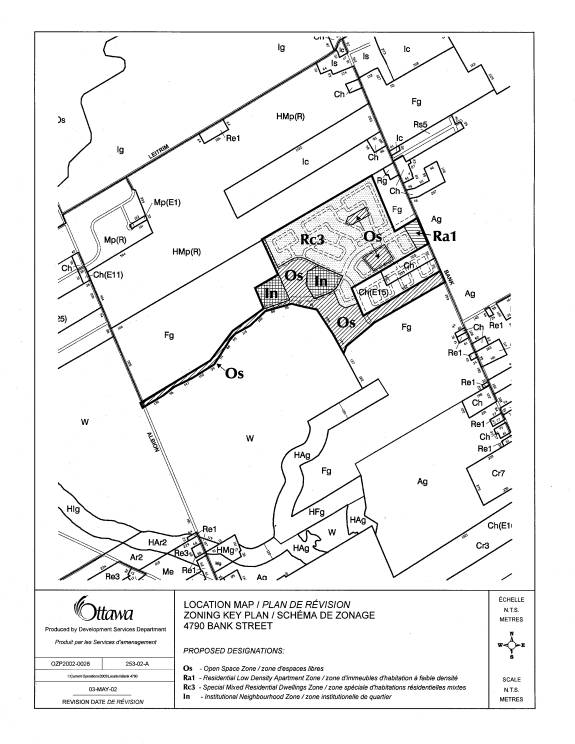
ZONING – 4790
BANK STREET
ZONAGE – 4790, RUE BANK
Chair Hunter
began by reading a statement required under the Planning Act, which advised that anyone who intended to appeal this
proposed Zoning By-law Amendment to the Ontario Municipal Board (OMB), must
either voice their objections at the public meeting, or submit their comments
in writing prior to the amendment being adopted by City Council. Failure to do so could result in refusal/dismissal
of the appeal by the OMB.
Ms. Currie
advised that Myles Mahon would be providing a brief presentation on report
dated 6 June 2002 and respond to any questions
Councillor Cullen pointed out there
was a considerable amount of sensitivity with respect to the wetlands issue
around Leitrim and his understanding is that there is currently a federal
environmental assessment taking place, which was confirmed. It was put to him that the outcome of that
assessment might have an impact on what was being discussed. The question put to him was whether it was
premature to consider this prior to that outcome. Mr. Mahon responded there were two assessments currently ongoing. There was the area-wide risk assessment to
deal with the contamination issue and the advise received is that no one
suspects there will be any concerns for development. Responding to another question, he indicated a representative
from the Ministry of the Environment was present to answer any technical
questions and there was a memo from the City’s Health Branch that indicates the
affects of contamination are unlikely.
The MOE district office does not feel the issues with contamination
should adversely affect the development in Leitrim. Councillor Cullen referred to due diligence and it would seem
wise to have those assessments concluded and determinations made, if indeed
they are made, before proceeding. Why
was the City not waiting for that process to come to completion, which would
certainly resolve some of the outstanding issues? Mr. Mahon responded that one of the main aspects is that there
were no adverse health impacts anticipated through the process for the
area. Tartan has a number of monitoring
wells for the Phase II lands they own closer to Albion Road. There is a large distance between the
landfill site and the area proposed to be developed in Leitrim closer to Bank
Street. Councillor Cullen heard that
the anticipated results of the area-wide risk assessment and the environmental
assessment will not have any effect on this development. Mr. Larry Morrison, Manager, Infrastructure
Approvals, responded by pointing out that, as in the past, when due process was
followed for OPAs, Draft Plan Approval of Subdivision, through the Planning
Act, the federal or provincial agencies were not coming forward objecting
to the zoning. That confirms to staff
they will not object and it was not premature to proceed with the zoning, even
though the studies themselves may not be totally complete. Councillor Cullen commented that the City
anticipates, but does not know there will not be a problem. Mr. Morrison advised that staff was meeting
with Fisheries tomorrow afternoon and were looking at the end of the summer to
have their report completed; and, the overall environmental review by Transport
Canada will probably be available in the early fall. Councillor Cullen suggested that if the Committee deferred the
matter till October, the results would be available and the Committee would be
able to know officially that these assessments were completed and whether or
not there was a problem. Mr. Morrison
declared there was sufficient information currently available that the federal
and provincial agencies would be flagging any difficulty.
Mary Hegan, on behalf of the Environmental Advisory Committee (EAC), and
its working group, were pleased to provide the study
resulting from many reports and letters and presentations to their Committee by
staff, friends of Leitrim and the Tartan Land Corporation, which is on
file. Paul Koch, EAC Chair, lead the
EAC study on the issue put before the Committee today, but was unable to be
present to speak to Committee. In
reviewing four to five inches of documentation, EAC realized that decisions
were made in the past on issues leading up to the zoning amendment before
Committee today. Past Councils,
provincial authorities, OMB and federal departments, made these decisions. Yet, EAC views that the present Council has
the responsibility to review the findings and conflicting recommendations on
all the scientific and technical reports, before making the zoning
decision. EAC feels the present Council
are accountable for future impacts on both the Leitrim Wetlands and public
health. EAC reviewed all the
documentation and scientific assessments in light of its mandate. As the city planner outlined, EAC sees three
priority issues before Committee. One,
is the wetland protection and the need to protect and maintain the few
remaining wetlands within the City for reasons listed in its brief. The second main issue is public health; the
potential for adverse affects to human and other animal health from toxic fumes
originating from the former Gloucester landfill site. And, the third issue is one of governance and due process. In reviewing everything and talking to a few
people, EAC’s specific recommendation on the zoning amendment is that it be
deferred until the City receives the permanent results from Fisheries and
Oceans and the Transport Canada Area-Wide Risk Assessment under the Federal
Environmental Assessment Act. The EAC
Environmental Assessment Committee should continue its work and look at that
documentation and report back when hopefully the zoning question will be looked
at.
If the City proceeds with the zoning
amendments, EAC has a number of other recommendations. One, there have been reports questioning the
total effect of the present storm water management pond. More importantly, is to have a mitigation
plan developed in case the remaining wetland water levels are lowered as some
experts have indicated is a possibility.
And, also if there are other signs of wetland damage as development
starts. EAC asks that the location of
the Rim Road directly adjacent to the Class I wetlands be looked at since there
currently appears to be no buffer in place to protect the remaining wetlands
and its flora and fauna. EAC asked for
full monitoring plans and emergency response plans with regular reports back to
Council and the public in place before development starts. There appear to be monitoring wells in place
and, as already heard from staff, there are other studies ongoing. There is a certain level of public concern
and interest on this issue. This
includes a post-construction plan for monitoring on a long-term basis the
contaminants from the Gloucester landfill that may migrate to and within the
housing and the two elementary schools planned for development. EAC also suggests as part of a monitoring
and review process that Council establish an external panel, with a mix of
expertise and perspectives to look at the ongoing monitoring and review process
suggested.
EAC has more long term
recommendations. EAC suggests there be
a complete inventory of remaining wetlands and that they be built into the new
OP and that there be a step by step protocol.
EAC wanted to be on record that it had some recommendations from the
issue before Committee today for future planning.
Philip Martin, provided written comments, which
were circulated to Committee members and are on file with the Clerk. The Leitrim Wetland contains an enormous
range of biodiversity that is not replicated anywhere else in the province of
Ontario. The material supporting this
has not been adequately reviewed. The
city is in danger of losing this wetland because of the inadequacy of the storm
water management system because the housing development is built at the lowest
part of the wetland and it is impossible to drain that area for housing without
affecting the rest of the wetland. He
is concerned that the experts; namely, Clark Top, Frederick Michel and Michael
Woodley, have not been consulted as peer reviewers, although this has been
suggested by many people. These experts
should have the ability and the right to comment on the original consultant
report by Cumming and Golden. There is
a wealth of information in the medical literature to show that human habitation
close to a waste site results in human health problems; notably, teratogeny and
Downs Syndrome. The latest papers by
Martine Fraihate and others have estimated that that risk is at least a third
as great as in an unaltered area. This
hazard does not appear to have been considered at all by Ottawa city officials,
nor by the consultants for Tartan Homes.
There is no mention at all in Cumming Cobourn or Golden consultants
reports. He suggested the decision to
rezone be delayed until the reports dealing with the problems become available
later this year; namely, the Area-Wide Risk Assessment, being conducted by
Transport Canada; and, the Environmental Assessment being produced by the Department
of Fisheries and Oceans, in collaboration with other federal departments. The latter study, in particular, is a major
study, not just affecting fish. If the
land is rezoned the land value will be raised considerably and add to the cost
of claims that could be made against the City if the land is not developed as a
result of a negative federal decision.
He was also concerned about the
numerous misstatements in the discussion section, on page 202-209, about the
Leitrim Wetland. There are statements
that the area naturalists as represented by the Leitrim Naturalists Group,
which contained representatives of the Ottawa Field Naturalists, have been
somehow in agreement with the boundary set and known as the core wetland. That is not and has never been the
case. He drew the Committee’s attention
to a letter written by Mike Murphy, in 1991, specifically objecting to both the
problem of the toxic contamination and the loss of biodiversity. Secondly, there was no health study of any
area residents on Del Zotto Avenue, nor any studies on air quality that would
justify the contention that there has been no expectation of health risks in
the rest of the area. If such studies
have not been done, the statement is highly misleading. He presumed that when such statements are
made there is scientific backing for it and asked for a copy of the data. The recent study by Vrijheid et al concludes
there are substantial health risks for persons living less than 3 k. from a waste
dump. Most of the Leitrim Wetland is
well within this distance. In view of
the ongoing Area-Wide Health Risk Assessment statements made by Mr. Lathrop
about the efficacy of the treatment by Transport Canada at the Gloucester
Landfill Site should be regarded as debatable as well as premature. In view of the studies being conducted,
there is no firm evidence to support the contention of the MOE that development
should go ahead.
Chair Hunter pointed out the
previous two speakers seemed to be under the impression the question was
whether residential uses were permitted, which is not the question. That is a question of OP and it was
designated as urban. The Committee is
dealing with the detailed zoning plan; the density, the location of the
streets, location of parks etc. He
asked that future speakers reserve themselves to the appropriateness of the
zoning, which is the issue before Committee.
Stan Rosenbaum [an e-mail submitting
the comments of the Ottawa Field Naturalists from Mr. Rosenbaum was circulated
to the Committee, and is on file]. Mr. Rosenbaum commented that
the report reflects that a Committee comprised of representatives from
the Ministry of Natural Resources, the Conservation Authority and Area
Naturalists established the boundary for the Leitrim Wetland in 1991. That statement clearly insinuates that Area
Naturalists were a party to the establishment of the boundary and agreed to it,
which was not the case. They did not
agree to it. One can assume the Area
Naturalists were included in the Committee to lend a kind of political
credibility to the decision, which was made against their advice. Another statement made in that same
paragraph, which said, “the area proposed to be rezoned, is outside the
boundary of the Leitrim wetland”. It’s
outside the boundary of the area that was parceled off to become the
wetland. That’s what remains after the
other part is drained and destroyed as a wetland of course. Then the remaining wetland is the wetland. The existing wetland as it stands now
includes the area of the storm water pond or water treatment and he delineated
it on the map. What’s on the table this
afternoon is only a small part of what appears to be the existing wetland, but
it does include the storm water treatment area which would require very deep
dredging and when carried out, there is a significant chance it will not
protect the wetland. A Committee
established the boundary and the area naturalists did not agree to that but are
being quoted as if they did.
The measures
proposed to preserve the remaining part of the wetland, is mentioned on the
next page of the document.
Professionals have raised concerns that the impenetrable liner may
itself be impermeable, but due to porosity of subsoils, the berm may be
ineffective. He was not aware of any
financial provision for eventual repairs to the barrier. And, if there are any future mitigation
measures required, they are going to be expensive and this should have been
acknowledged under the heading of financial implications which presently state
“not applicable”. In view of ongoing
federal investigations, rezoning at this time would be premature, as several
previous speakers have said.
Councillor Deans
wanted to be clear about the paragraph referred to on page 202 of the report
pertaining to the Area Naturalists, since he was not the first person who
raised it, she wanted to be clear if the statement was accurate. Was it his understanding that the Area
Naturalists participated in a Committee to establish the boundary for the Leitrim
wetlands in 1991? Mr. Rosenberg responded
they participated in a Committee.
Councillor Deans was not reading that insinuation in the paragraph. The report indicates a Committee established
the boundary for the Leitrim wetland in 1991.
Committees make many decisions, but it doesn’t mean everyone sitting
around the table agrees with the decision(s).
She did not read that the Area Naturalists necessarily concurred with
the decision reached. She did not want
to leave the impression that staff deliberately misled this Committee or
Council in any statement.
In response to a
question by Councillor Cullen, Mr. Rosenberg indicated he would support a
motion to defer the zoning amendment until after the required permit from
Fisheries and Oceans was received and the Transport Canada Area Wide Risk Assessment
under the Federal Environmental Assessment Act was completed. But, on further questioning by Chair Hunter,
he added that the Field Naturalists did have other objections to the
application.
Councillor
Stavinga asked if there was further assessment with regard to the wetland
boundary since she had found the boundaries reflected in the 1997 Regional OP
were not accurate. They were more
extensive; and, as a consequence, resulted in debate at Committee on a recent
subdivision. She also questioned if the
OMB played a role in the wetland boundary.
Mr. Mahon pointed out the Ministry of Natural Resources was responsible
for the wetland boundaries in Ontario, which are the boundaries used in
establishing the area to be designated in the 1997 OP. He was not aware of any evaluations made
between 1991 and 1997. The storm water
management facilities went through the Environmental Assessment Process and
deemed to be sufficient study to determine what could go into the adjacent
lands for the wetland. Mr. Morrison
added that the boundary, as it exists on the Tartan lands, was defined by the
Committee referred to several times.
The Ministry of Natural Resources defined the boundary that lies in the
Reimer lands at an OMB hearing. So the
boundary as it’s know now on the Tartan lands has been in existence for quite
some time and reviewed again during the Region’s OP and confirmed to be the
actual boundary for the wet land, with no appeal.
In responding to
a further question, Mr. Lindsay recalled that when the application came forward
it was reviewed in detail by Ministry of Natural Resources, as Mr. Morrison
said, as well as this Committee. It
would be the detailed review that took place on the Tartan lands; the lands were
walked, surveyed, mapped and then provided to the then City of Gloucester with
respect to the delineation of the FG zone and the open space corridor. It was a fairly detailed exercise similar to
what has occurred and has been occurring in Stittsville. In clarification, the re-zoning proposed by
staff respects the boundary as it was defined and included the buffer zone.
Erwin
Dreesen, Greenspace Alliance, observed the advice from staff continues to
maintain an extremely myopic view of what the Federal Assessment is all
about. He referred to page 205, middle
of the page, where the staff report says “The assessment addresses only the
Fisheries Compensation Agreement for Findlay Creek and will not impact on the
approved storm water design.” It was an
unsustainable position. He exampled the
letter recently received from Ministry Thibault, Minister of Fisheries and
Oceans and he quoted just a few phrases in the middle of the page, which he
distributed and is on file. In the
middle of the page it says that “Health Canada and Environment Canada are
respectively the two Federal Departments with mandates addressing the potential
for contaminant impacts on human health and the ecosystem. Accordingly, says the Minister, I’ve taken
the liberty of forwarding copies to his two colleagues, the Ministers of Health
and Environment for expert advice as it relates to the Environmental Assessment
as prescribed by subsection 12(3) of the Canadian Environmental Assessment Act
(CEAC). Transport Canada, Agriculture
Canada and Natural Resources Canada have also been contacted for advice and
input regarding the screening report. That makes a total of six federal
departments now involved in preparing a draft screening report. This clearly demonstrates there’s more
involved than fish in Findlay Creek or mere Fisheries compensation agreement is
at issue. There are replies from
several Ministers that indicate clearly the onus is on the proponent to provide
more information because there is not enough information on the record to do a
full assessment. DFO has decided to
await the outcome of Transport Canada’s Area Wide Risk Assessment before
finalizing it’s draft screening report; i.e. the draft screening report will
not be forthcoming before the fall. In
the words of the Minister of Fisheries and Oceans “the draft screening report
will provide ample opportunity for public comment”. Transport Canada plans to hold an open house after the peer
review of its area wide risk assessment is in.
On peer reviews, here is the latest advice from experts at the
Geological Survey of Canada, Hydrogeology Section. The advice goes on for ten pages, and there is a documents list
and an appendix attached to that. It
concludes that the review documents do not provide sufficient data and analysis
to conclude that the proposed storm water management facilities will not have
adverse effect on water levels in the wetland.
It goes on to say the reported base flow data is insufficient. It also says that the hydraulic conductivity
of the peat and bedrock are insufficiently characterized. It says finally, the installation of the
geo-synthetic clay liner may require significant excavation. Dewatering of this excavation could lower
ground water levels in the wetland.
There is no indication that this issue has been considered and
assessed. Monitoring of water levels in
the wetlands following construction of storm water management facilities does
not appear to be planned yet would be appropriate. How much clearer can we make it?
That the proponent may have to revise his plans, perhaps, even abandon
them altogether. Believing that the
outcome of this federal assessment will have no impact on zoning and the plan
of subdivision is quite a heroic assumption.
We therefore urge you to defer consideration of this zoning
amendment. In the alternative should
Committee wish to go ahead, at least delay passage of the zoning by-law until
after final disposition of the Federal Environmental Assessment. This would avoid an appeal to the OMB as a
precautionary measure. The OMB would
not want to hear this case until final disposition of the Federal
Assessment. Finally, the Green Space
Alliance and several of its members have submitted detailed comments to staff,
and the objections are based on the Planning Act, the Provincial Policy
Statement, on the Regional OP and on Charting a Course principles. In closing, under the current plans
identified regionally rare and sparse plant species will be destroyed; in one
case, even eliminated from the wetland.
Secondly, there’s a mature wood stand with more than 70 trees in 100-200
year old range that will be ruined if the proposed discharge channel is
constructed. [Documentation received is
on file.]
Pierre
Dufresne, Manager of Land Development, Tartan Land Corporation. The project has a 12
year history and this is the final implementation. Tartan is enacting what was always conceived for the property;
‘Residential dwelling units, parks, schools and storm water management
uses.’ He would be answering some
statements made by earlier presenters that were misconceptions or
misleading. First, the designation of
the wetland boundary did undergo an extensive public consultation, not only
with all the technical review agencies with the federal, provincial and
regional levels. All those that have
authority, agreed with the proposal and how to protect the wetland from the
effects of adjacent developments and notwithstanding what was said before,
there was a group called the Leitrim naturalists group that supported the
endeavor. That group was made up of
members of the Ottawa Field Naturalists, Sierra club, members of the public, environmental
advocates who have since written letters that have objected to it. There is a letter on file that states they
unequivocally support what was agreed upon.
It does state that it may not be the best-case scenario for them, but
understand that under the planning process it’s a good and fair solution. Tartan has been painted the bad guys, but
undertook the public consultation on wetlands designated urban land purchased
at urban values, with a legal right to develop those lands. Tartan is donating over 230 acres of this
wetland to the South Nation Conservation Authority for a tax receipt and
protecting that wetland, spending millions of dollars on a stormwater
management system that will ensure the protect of that wetland; given up
authority to legally do anything on that wetland, not only through conveyance
but by supporting the former Region to re-designate those urban lands to
wetland, without appeal. Tartan is
providing financial contributions to the South Nation Conservation Authority
and setting up partnerships for them to be able to develop those wetlands in
terms of recreational, passive and educational facilities. Tartan will donate its sales centre to them,
to turn it into a interpretation centre.
These
wetlands will be protected, but the experts with the Ministry of Natural
Resources and Environment Canada, local, the provincial environment department,
the conservation authority, hydro-geologists, biologists stormwater management
experts, anyone with authority over these lands agree and support what Tartan
is doing. Unfortunately everyone can’t
be convinced, and some of those people know how to very effectively challenge
any type of process that requires public approval. It was suggested this may be premature given the federal
assessment. There are two components to
the federal assessment; there is the fish compensation agreement and tied into
that is the wetland issues and the contamination issue. The technical matters with the fish
compensation agreement and the wetland issues have all been agreed upon with
the Department of Fisheries and Oceans; in fact, they dictated what needed to
be done. It was extensive and will cost
more money. Tartan agreed not only to
rehabilitate that part of the fish habitat that will be disturbed by the
channellization of the creek; mitigate against the damage, but also improve and
enhance that fish habitat for the protection of the fish to be able to survive
and flourish. The contamination issue
is not new. That contaminated site was
identified in the 1980s; the landfill was removed. It was identified there are contaminants in both the shallow and
deep aquifers. Testing has been ongoing
to ensure that migration does not come onto the property. Tartan does not want to have contaminated
lands and wants to make sure it is not.
The Ministry of the Environment, the city health department, federal
government departments, Health Canada, Environment Canada and Transport Canada
are all monitoring the situation and have all agreed through their comments on
this federal process that the development should not be precluded or
delayed. Tartan is awaiting the final
copy of the study. Does zoning jump the
cue of the results of this study, no, there is a condition for approval that
determines that the federal assessment process has to be completed prior to the
conveyance of any lot in this subdivision.
So whether this property is zoned or not, it will be enforced. If there is one threat of contamination and
health risk on the property, the Ministry of the Environment has the statutory
authority to shut Tartan down. The
zoning should be approved.
Councillor
Deans highlighted the condition she asked staff to include in the draft plan of
subdivision that says no agreement of purchase and sales shall be finalized
until such time as the approval from the Department of Oceans and the
Certificate of Approval from the Ministry of Environment and Energy are
granted, which Tartan agreed to. She
brought it to the attention of the Committee because it addresses some of the
issues heard around the table in terms of having a condition in the final
subdivision that gives some protection for those approvals.
Councillor
Cullen explained that the amendment he was putting forward deals with the
required permit, which seems to be covered by the remarks just heard, but also
deals with the Transport Canada Area Wide Risk Assessment under the Federal EA
Acts. This is expected to be completed
by the fall and questioned if the four-month delay would be a problem. Mr. Dufresne responded that Tartan hoped
that some of the processes, which need to be completed to build units, run
concurrent. If Tartan were to wait
until the finalization of that report, the next step would be that the report
would go to the department of Fisheries and Oceans for authorization with
another two month delay for completion and then another couple more months for
the zoning to be completed with the opportunity for appeal. It would end up extending well into next
year so Tartan would prefer that the processes run concurrently. For the protection of the concerns about the
contaminated waste site and the wetlands, if the zoning is approved today and
by council at the end of July, it will not impact or prejudice those concerns
because there are already other protective measures the municipal planning
process and through provincial statute to meet those interests.
Councillor
Cullen pointed out that if the decision is appealed to the OMB, the Board would
be unwilling to be seized because of the outstanding studies, particularly the
Transport Canada Area Wide Risk Assessment.
Mr. Dufresne responded that although it will be extremely useful when
completed he did not agree the OMB would require that the studies be complete
because Transport Canada are commissioning the studies. They are on the record that they do not want
to see development interrupted; the locally Ministry of the Environment are
also on the record there was no reason to stop development. The area wide risk assessment was an
insurance policy. There was ongoing
monitoring and testing on the property and extensive testing on properties west
of the boundary, with no indication there is a human health risk threat on the
property. All the applicable agencies
agree with that assessment.
Barbara Barr
was in support of Couuncillor Cullen’s motion to defer the zoning until after
the Federal Environmental assessment which began in February 2000. This is not a simple assessment. Section 5.5.2, Policies for Adjacent Lands
of the Regions OP reads, “Council shall 1. Permit development and site
alteration on lands adjacent to provincially significant wetlands designated on
Schedules A and B, only if the following conditions are met: a) … b) It is
demonstrated that the proposed development or site alteration will not have any
negative impacts on the natural features or on the ecological functions for
which the area is identified as described in the wetlands evaluation undertaken
by the Ministry of Natural Resources.”
That section of the OP simply reflects a provision in Subsection 2.3.2
of the Natural Heritage Section of the provincial policies statement, so the
OMB would definitely be interested if the community was forced to appeal a
premature zoning action to the OMB. The
item proposed to be adjacent to the provincially significant wetland that has
the potential to have a negative impact on it is the storm water management
system, the drainage ditch, the pond in the lowest part of the wetland and the
discharge channel. Those are proposed
to be zoned OS. Natural Resources
Canada has substantial concerns about the storm water works. Agriculture and Agri Food Canada soils
expert had this to say in a letter to DFO, dated March 7, 2002. “Hence this uncertainty about the adequacy
of the hydrologic barrier the protecting the hydrologic conditions of the
wetland core still exists. Uncertainty
about whether a proposal will result in significant adverse effects is one of
the elements that could cause the DFO to refer the proposal to the Minister of
Environment for mediation or a panel review.
At present, federal departments are indicating uncertainty bordering on
no confidence about the ability of the storm water system to exist in the
proposed location without draining water from the provincially significant area
of the wetland. Basically the federal departments are asking for more
information so that they can consider the matter additionally before reaching
their conclusions. If staff think this
environmental assessment is just about a fisheries compensation agreement they
had better consult the case law on environmental assessments. No matter how much you want to see this
development proceed, it is inappropriate to pre-judge the results of the
federal assessment and she encouraged the Committee to defer the zoning. If councilors want the federal agencies like
the NCC to respect the planning processes the Committee had better be prepared
to respect the federal government’s processes.
She directed the
Committee to a diagram she handed out.
She asked a botanist to draw the wetland boundary on top of the
zoning. He drew in the boundary of
Cumming Cockburn, who is the consultant for the developer. He drew in a similar boundary of the Ontario
Ministry of Natural Resources. There’s
no dispute that the wetland is this big.
So now there is a little artificial kind of line that resulted from an
OMB decision, there is the provincially significant wetland. The other wetland is simply to be developed
wetland. You have to be careful when
you are talking about wetland, it’s the provincially significant wetland. When people have been talking about wetland,
they have only been talking about the part that’s going to the South Nations
Conservation Authority. This is also
wetland. How did the OMB make such a
decision? It might have been related to
an economic return for the owner. But
there is the responsibility of not hurting the provincially significant wetland
when working adjacent to it. She
pointed out the mature woodland with 70-200 year old trees in the discharge
channels of the storm water works. They
should be moved elsewhere. Two of the
rarer plants are in one of the institutional zones; and, two others are in the
storm water pond. She proposed that the
wetland portion of the site be zoned OS.
In conclusion, she asked for an information and comments session in the
community, which is needed, since this is Phase 1 of an entirely new growth
area, it ought to demonstrate some smart growth principles, and should be
discussed. In a written statement she
submitted yesterday, which is on file, she read “ I reason that zoning now
before the report of the federal environmental assessment has been issued,
creates a no-win situation for everyone because it essentially forces community
people to appeal to the OMB which takes the decision-making out of the city’s
hands and it inconveniences the developer.”
She didn’t think the OMB would rule until the federal report is completed;
the reason being that the provincial approval is conditional. One of the conditions is the fisheries and
the storm water approval. That doesn’t
happen until the environmental assessment is complete and that raises more
issues beyond fisheries. She urged
deferral.
In response to a
question by Councillor Stavinga, Mr. Mahon related that was a boundary
originally floated when M&R first did the assessment in 1989. Since then, it has undergone a number of
re-iterations and the boundary defined as a significant wetland in the Leitrim
area is the one on the zoning map. That
was accepted by the Ministry of Natural Resources and went through a public
consultation process for the regional OP; and, Gloucester Zoning By-Law, in
1999, in terms of the province and the city.
He demonstrated the wetland boundary on the map. Councillor Stavinga commented it was the
straightest wetland boundary she had ever seen, but it was defined by decision
with regard to certain uses coming into play encroaching on the wetland. In response to a further question by the
Councillor, Mr. Mahon clarified that it was a standard condition for a plan of
subdivision that the zoning had to be in place and the appeal period expired
before the subdivision could be registered.
Many of the issues raised today were discussed during the subdivision
approval process. It was originally
draft-approved in 1994, and revised by the Region in 1996. Since then it needed an extension of the
draft approval and at that time Tartan decided to submit a different concept,
so there was a revised plan submitted in 2000.
It went to the Planning and Advisory Committee, which is a public
meeting of the City of Gloucester for the local conditions for the
subdivision. The subdivision was
approved under delegated authority to staff, in June 2002.
Councillor
Stavinga received further clarification that the plan of subdivision is
approved and the lands are subsequently re-zoned to implement those decisions.
Moved by
Councillor Cullen:
That consideration of the proposed zoning amendment for 4790 Bank Street
be deferred until after the required permit from Fisheries and Oceans has been
issued and the Transport Canada Area-Wide Risk Assessment under the Federal
Environmental Assessment Act has been completed.
LOST
YEAS (3): Councillors Cullen, Munter, Stavinga
NAYS (4): Councillors Bellemare, Hume, Harder,
Hunter
Moved by J.
Harder:
That the Planning and Development
Committee recommend Council approve an amendment to Zoning By-law 333-1999
(former City of Gloucester) to change the zoning of 4790 Bank from Fg (Future
Growth Zone) to RC3 (Special Mixed Residential), RA1 (Low Density Apartment),
OS (Open Space), and In (Institutional Neighbourhood).
CARRIED
YEAS (4): Councillors Bellemare, Hume, Harder,
Hunter
NAYS (3): Councillors Cullen, Munter, Stavinga