Report to/Rapport au :
Planning
and Environment Committee
Comité de l'urbanisme et de l'environnement
and Council / et au Conseil
09 January 2009 / 09 janvier 2009
Submitted by/Soumis par : Nancy Schepers, Deputy City Manager
Directrice municipale adjointe,
Infrastructure
Services and Community Sustainability
Services d’infrastructure et Viabilité des collectivités
Contact Person/Personne ressource : Danny Page,
Acting Manager/Gestionnaire intérimaire, Development Approvals/Approbation des
demandes d'aménagement, Planning and Growth Management/Urbanisme et Gestion de
la croissance
(613) 580-2424, 27595 Danny.Page@ottawa.ca
|
SUBJECT: |
ZONING - 3530 and PArt of 3538
Jockvale Road (FILE NO. D02-02-08-0113) |
|
|
|
|
OBJET : |
REPORT RECOMMENDATION
That the recommend Council approve an amendment to Zoning By-law
2008-250 to change the zoning of 3530 and part of 3538 Jockvale Road from
DR (Development Reserve Zone) and R3Z [1435]-h (Residential Third Density
Subzone Z, Exception 1435, Holding) to R1Z [664] (Residential First Density
Subzone Z, Exception 664), R3Z [xxxx] (Residential Third Density Subzone Z,
Exception xxxx), and R4Z [xxxy] (Residential Fourth Density Subzone Z,
Exception xxxy), as shown in Document 1 and as detailed in Document 2.
RECOMMANDATIONS DU
RAPPORT
Que le Comité de recommande au Conseil d’approuver une modification au Règlement de
zonage 2008-250 afin de changer la désignation de zonage du 3530 et d’une
partie du 3538, chemin Jockvale de DR (Zone d’aménagement futur) et de R3Z
[1435]-h (Zone résidentielle de densité trois, sous-zone Z, exception 1435,
aménagement différé) à R1Z [664] (Zone résidentielle de densité un, sous-zone
Z, exception 664), et à R4Z [xxxy]
(Zone résidentielle de densité quatre, sous-zone Z, exception xxxx), comme il
est indiqué dans le document 1 et expliqué en détail dans le document 2.
BACKGROUND
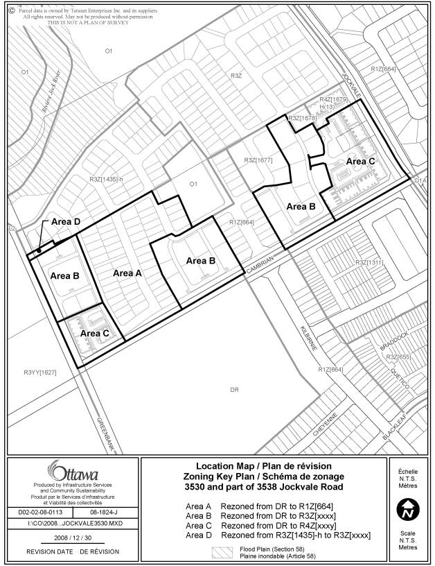
The subject lands are located to the south of Jock River, flanked by Jockvale Road to the east, Cambrian Road to the south and Greenbank Road to the west. The 10.5-hectare parcel is currently vacant and surrounded by existing and planned residential developments. It is part of Stonebridge Phase 10 North subdivision which is comprised of a mix of lots for single detached, multiple attached and blocks for stacked townhouses. The subdivision was draft approved on July 11, 2008. A Zoning By-law amendment (file number D02-02-08-0061) was submitted and approved for a small portion of the Stonebridge Phase 10 North lands. This application is to rezone the remainder of the lands.
Purpose
of Zoning Amendment
The purpose of this request is to develop 52 single detached houses, 139 street townhouses and 122 stacked units.
A large majority of the subject land is currently zoned DR (Development Reserve), which is intended to recognize lands for future urban development while allowing limited interim uses including agricultural, conservation, and rural residential. A small piece of land in the northeast corner (shown as Area D in Document 1) is currently zoned Residential Third Density Subzone Z - R3Z [1435]-h, which permits detached, semi-detached and multiple attached dwellings, as well as planned unit developments
The proposed zoning for Area A (as shown in Document 1) is R1Z [664] that permits only detached dwellings. A provision is made to specify the maximum accessory building height.
The proposed zoning for Area B is R3Z [xxxx]. This zone permits detached, semi-detached and multiple attached dwellings, as well as planned unit developments. The site-specific zone exception would specify the projection from a garage to a main wall and yard setbacks for planned unit developments.
The proposed zoning for Area C is R4Z [xxxy]. This zone permits stacked and apartment dwellings in addition to all uses permitted under R3Z zone. The site-specific zone exception would specify a reduced building height, reduced driveway width, provisions for permitted projections, and yard setbacks for planned unit developments.
The proposed zoning for Area D is R3Z [xxxx], which is consistent with Area B.
Revisions to the Original Application
The original application, as submitted on October 10, 2008, only included Areas A, B and C as shown in Document 1. On December 17, 2008, as requested by the applicant, a strip of land adjacent to the northwest corner of the site was added to this application. This area is identified as Area D in Document 1.
DISCUSSION
The Official Plan designates the
property General Urban Area. This
designation permits the development of a full range and choice of housing types
to meet the needs of all ages, incomes and life circumstances, in combination
with conveniently located employment, retail, service, cultural leisure and
institutional uses.
The Council approved Barrhaven South Community Design Plan (CDP) is a statutory document that complements Official Plan policies and provides more detailed guidance regarding the form and character of Barrhaven South. The site is located on the northeast corner of the CDP Sub-Planning Area 1. Under the CDP, the lands at the northeast corner of Greenbank-Cambrian intersection and at the northwest corner of Jockvale-Cambrian intersection are designated Medium Density Residential, which permits all forms of ground-oriented multiple dwellings, including street townhouses and stacked units. The remainder of the lands are designated Low Density Residential, which permits detached, semi-detached as well as multiple attached dwellings.
Analysis
The proposed development consists of various dwelling types from singles and street townhouses to stacked units. It is consistent with the policies as outlined in the Official Plan and Barrhaven South CDP in that the new neighbourhood will provide a range of housing options and opportunities.
The site is adjacent to two arterial roads. The location and proposed land uses comply with the CDP Land Use Plan as well as with Sections 5.1.2 and 5.1.3, thereof which require that Medium Density Residential housing shall be focused along arterial and collector roads, major intersections and at neighbourhood focal points. Multiple dwellings are permitted within Low Density Residential areas provided their location is consistent with above noted locational criteria.
The overall residential density of the area is 38 net units per hectare, which meets the density target of 37.3 net units per hectare for the Sub-Planning Area 1 as set out in the CDP.
The subject lands are located in the Stonebridge Phase 10 North Subdivision and are surrounded by lands that are zoned R1A, R3YY, R3Z and DR. The proposed R1Z and R3Z zones are consistent with those zones. The proposed R4Z zone will allow stacked units and permit a maximum building height of 13 metres. Compared to the surrounding residential zones that permit a maximum building height of 11 metres, the increase in height is minimal and the impact is insignificant. The proposed stacked units will have similar qualities with respect to their setbacks, massing and character as nearby street townhouses.
Conclusion
The proposed land use fully conforms to the applicable policies as outlined within the Official Plan and Community Design Plan. The proposed exceptions are generally minor in nature; the exceptions to the setbacks and projections help promote an enhanced street presence; and the exception to the building height helps improve the compatibility of the proposed development. The Department supports this application.
CONSULTATION
Notice of this application was carried out in accordance with the City's Public Notification and Consultation Policy. The Ward Councillor is aware of this application and the staff recommendation. Details of the consultation are shown in Document 3.
LEGAL/RISK MANAGEMENT IMPLICATIONS:
N/A
FINANCIAL IMPLICATIONS
APPLICATION PROCESS TIMELINE STATUS
This application was processed by the "On Time Decision Date" established for the processing of Zoning By-law amendment applications.
SUPPORTING DOCUMENTATION
Document 1 Location Map
Document 2 Details of Recommended Zoning
Document 3 Consultation Details
DISPOSITION
City Clerk and Legal Services Branch, Legislative Services to notify the owner/applicant, Rob Pierce, Monarch Homes, 3584 Jockvale Road, Nepean ON K2C 3H2, OttawaScene.com, 174 Colonnade Road, Unit #33, Ottawa, ON K2E 7J5, Ghislain Lamarche, Program Manager, Assessment, Financial Services Branch (Mail Code: 26-76) of City Council’s decision.
Infrastructure Services and Community Sustainability Department to prepare the implementing by-law, forward to Legal Services and undertake the statutory notification.
Legal Services to forward the implementing by-law to City Council.
LOCATION MAP DOCUMENT 1
DETAILS OF RECOMMENDED ZONING DOCUMENT 2
Proposed Changes to the Comprehensive Zoning By-law 2008-250
1) That the lands known municipally as 3530 Jockvale Road and part of 3538 Jockvale Road, shown as Areas A to D in Document 1, be rezoned as follows:
Area A from DR to R1Z [664]
Area B from DR to R3Z [xxxx]
Area C from DR to R4Z [xxxy]
Area D from R3Z [1435]-h to R3Z [xxxx]
2) Two new exception zones, xxxx and xxxy, will be added to Section 239 with the following provisions, or provisions having the same effect:
|
|
|
Exception
Provisions |
||
|
I |
II |
III |
IV |
V |
|
xxxx |
R3Z[xxxx] |
|
|
-maximum
distance the front wall of a private garage may extend beyond the building
front wall, sidewall, covered porch or veranda: 2.7m for multiple
attached dwelling buildings in a PUD, - minimum setback from a rear lot line to a building
sidewall is: 1.2 m - minimum setback from an interior side lot line to a
building sidewall is: 1.2 m. |
|
xxxy |
R4Z[xxxy]
|
|
|
-minimum
driveway and aisle width: 6.5m -maximum permitted height above finished grade of steps projecting into
any required yard: 1.8m -minimum
distance between a permitted projection and a lot line: 1.0m -maximum
building height: 13m for stacked
dwelling buildings in a PUD, -
minimum setback
from a rear lot line to a building sidewall is: 2.5 m -
minimum setback
from an interior side lot line to a building sidewall is: 2.5 m.
|
CONSULTATION DETAILS DOCUMENT 3
NOTIFICATION AND CONSULTATION PROCESS
Notification and public consultation was undertaken in accordance with the Public Notification and Consultation Policy approved by City Council for Zoning By-law amendments.
PUBLIC COMMENTS Summary
The following comments were received as a result of the public notification:
1. We do have some concerns with this, mainly privacy and
overcrowding. One of the reasons we chose this neighbourhood was for the
privacy and nice areas of greenery. We
wonder how many stacked townhouses currently exist in this neighbourhood, and
if any of them face Jockvale.
2. I hope that Monarch and the City in these early development
stages will preserve some of the mature trees on the lot
that had dwelling demolition earlier this year (3530 Jockvale Road).
They removed some mature deciduous trees. There still remain many very
mature coniferous trees. The Tree
Preservation Plan by Muncaster is only for the lands currently of the first few
phases of the development and excluded 3530 Jockvale which possess' these
mature trees.
Staff
Response
1. About nine buildings of stacked units are proposed around the
corner of Jockvale Road and Cambrian Road, each consisting of 12 or 14
units. Four of those buildings will be facing Jockvale Road. The
applicant had made changes to the original proposal to remove all balconies
facing Jockvale Road.
2. This rezoning proposal is associated with a subdivision application in which the Tree Preservation Plan was reviewed. In order to address the tree preservation issues at 3530 Jockvale Road, an updated Tree Preservation Plan has been requested and must be approved by the City prior to the registration of the subdivision. The applicant intends to preserve a number of the coniferous trees and has purposely designed the development concept to accommodate them within the open space area on the plan.
COMMUNITY ORGANIZATION COMMENTS Summary
Stonebridge
Community Association (December 12,
2008)
The community
is expected to endure planned 4-lane arterial traffic volumes on a roadway
(Jockvale) that is designated 2-lane rural & probably will remain that
way. We are looking to the city for solutions in containing additional
local traffic which is going to be combined with already existing very
significant thru traffic volumes on Jockvale. We already have
traffic tie-ups on Jockvale. This situation is not a basic BRT fix. We would
therefore recommend:1) that the 83% planned multiples for this phase actually
be reduced to 50% because of the aggregate existing & planned multiples in
this particular area; 2) that the proposal to introduce stacked townhouses be completely eliminated from this
amendment.
Staff Response
A Traffic Impact Study (TIS) for Stonebridge Subdivision Phase 10 to 12 concludes that the intersection of Jockvale Road and Cambrian Road will operate at acceptable levels of service during the weekday morning and afternoon peak hours of traffic at the 2018 study horizon year. The proposed dwelling types and density measures are consistent with applicable Official Plan and CDP policies.
Advisory Comiittee Comments Summary
Ottawa Forests and Greenspace Advisory Committee (December 2, 2008)
1.
Relocate the
four single lots to allow for single loaded roads to surround the future park.
2.
As a
condition of approval for the zoning bylaw amendment, and considering that no
attempts have been made to Design with Nature, request that additional planting
of mature trees be included in the proposed park setting and, given the limited
planting space of the proposed front yards, request that tree clusters be
incorporated in larger areas (such as corner lots, open space, entrance
features etc) within the boundaries of this application.
3.
Re-balance
the distribution of the multiple units so that the eastern and western portions
of the site are comparable: Spread-out the units and mix with single and semi
throughout the entire plan.
4.
Match the
proposed growth for this area to the original housing densities of the CDP
Overall so that you do not have such a disproportionate representation of
single & semi to multiples (town & stacked):44%- 47% single & semi
compared to the proposed 14%-17% ; and 43%-46% Multiples compared to the proposed
83% - 86%.
5.
Reduce the
unit count and mix to a level that the current road infrastructure can
accommodate.
Staff Response
1. The design of the future park complies with the CDP Design Guideline 6.4.3 in that it provides full frontage on at least two public streets.
2. Landscape Plans will be required and reviewed during the site plan control stage.
3. The proposed housing types and their location are consistent with the Land Use Plan in the CDP.
4. The housing distribution of a larger area is 54 per cent of singles and semis and 46 per cent of multiples, which is close to the housing distribution targets as set out in the CDP. This is consistent with the CDP Policy 7.3.4 in that while the overall CDP will achieve the desired mix of uses and densities, each subdivision may not.
5. A Traffic Impact Study (TIS) for Stonebridge Subdivision Phase 10 to
12 concludes that several intersections, including those at Greenbank/Cambrian,
Cambrian/Kilbirnie and Jockvale/Cambrian, can operate at acceptable levels of
service during the weekday morning and afternoon peak hours of traffic at the
2018 study horizon year. Roadway
modifications are further recommended to safely accommodate future traffic
generated by the development.