Report to/Rapport au :
Planning and Environment Committee
Comité de l'urbanisme et de l'environnement
and Council / et au Conseil
31 August 2007 / le 31 août 2007
Submitted by/Soumis par : Nancy Schepers, Deputy City Manager/
Directrice municipale adjointe,
Planning, Transit and the Environment/
Urbanisme, Transport en commun et Environnement
Contact Person/Personne ressource : Karen Currie,
Manager / Gestionnaire, Development Approvals / Approbation des demandes
d'aménagement
(613) 580-2424, 28310 Karen.Currie@ottawa.ca
|
SUBJECT: |
ZONING - 199 AND 200 KENNEVALE DRIVE, 155 PREM CIRCLE, 755 COBBLE HILL
DRIVE, 300, 309 AND 350 MOFFATT POND COURT AND 674 LIMERIDGE CIRCLE. |
|
|
|
|
OBJET : |
ZONAGE - 199 ET 200, PROMENADE KENNEVALE, 155, CERCLE PREM, 755,
PROMENADE COBBLE HILL, 300, 309 ET 350, COUR MOFFATT POND ET 674, CERCLE LIMERIDGE |
REPORT
RECOMMENDATION
That the recommend Council, in order to implement an Ontario Municipal Board
decision, approve an amendment to the former Nepean Zoning By-law to change the
zoning of 199 and 200 Kennevale Drive,
155 Prem Circle, 755 Cobble Hill Drive, 300, 309 and 350 Moffatt Pond Court and
674 Limeridge Circle from
Residential Mixed Unit - RMU Zone to Community Commercial Exception - CC Block (XX) Zone and Commercial
Automotive Exception - CA1 Block (XX) Zone as detailed in Document 2 and as shown in Document
1.
RECOMMANDATION DU
RAPPORT
Que le Comité de l'urbanisme et de l'environnement
recommande au Conseil d’approuver une modification au règlement de zonage de
l’ancienne Ville de Nepean visant à faire passer la désignation de zonage des
propriétés situées aux 199 et 200, promenade Kennevale, au 155, cercle Prem, au
755, promenade Cobble Hill, aux 300, 309 et 350, cour Moffatt Pond et au 674,
cercle Limeridge, de RMU (zone d’utilisation résidentielle mixte) à CC Bloc
(XX) (zone commerciale communautaire - Exception) et CA1 Bloc (XX) (zone
commerciale routière - Exception), comme le précise le document 2 et l’illustre
le document 1, et ce, en vue de mettre en oeuvre une décision de la
Commission des affaires municipales de l'Ontario.
BACKGROUND
The two parcels of land subject to this Zoning By-law amendment application are located between Cedarview Road and Strandherd Drive, immediately to the west of the existing Barrhaven community and east of the area designated and zoned for Prestige Business Park. The sites are on the north-and south-east corners of the intersection of Kennevale and Strandherd Drives.
A subdivision approval was granted in December
2004 for the surrounding lands for the development of single detached and
townhouses dwelling units, along with an institutional and park block. This
development is underway and a number of units have now been built and are
occupied in the immediate vicinity of the proposal.
The application for a Zoning By-law amendment
is in response to an Ontario Municipal Board (OMB) Decision granted in April
2006, which changed the designation of the subject lands from Residential Area
to Commercial. With the original subdivision application in 2003, the applicant
had filed an application for an Official Plan Amendment to permit commercial
development in this location. The existing Official Plan policy at the time did
not support this request. An appeal of the Council decision refusing the OPA
was successful at the OMB. The subject Zoning By‑law amendment responds
to the OMB order No. 1165.
DISCUSSION
Purpose of Zoning Amendment
The proposed Zoning By-law amendment
will introduce
two new commercial sites to this area, not originally contemplated in the
Secondary Plan for Area 9 and 10, with a development capacity up to 6510
square metres and a gas station use.
The existing zoning is a Residential Mixed Unit – RMU Zone, which permits residential uses such as single-detached, semi-detached, townhouses and rooming houses. This zone was introduced on these lands when the subdivision was approved in 2004 and to ensure compliance with the Secondary Plan policies for Area 9 and 10 of the former City of Nepean.
Two zone
categories are proposed for the sites. The land to the south of Kennevale Drive
(identified as parcel “A” on Document 1) is proposed to be a Community
Commercial (Exception) - CC Block XX Zone, which will allow the following uses:
•
Bake Shop
•
Bank
•
Brew on premises
•
Business office / medical/dental office
•
Cinema
•
Convenience store
•
Day nursery
•
Garden centre
•
Kitchen and bath showroom
•
Outdoor vehicle or merchandise sale
•
Place of amusement
•
Refreshment vehicle
•
Respite care facility
•
Restaurant take-out
•
Restaurant
•
Retail store
•
School, School commercial, and School private
•
Service and repair shop
•
Service Establishment
•
Special event outdoor sale
•
Supermarket, for the sale of fresh and frozen foods.
• Veterinary establishment
The exception is necessary in order to:
Add a supermarket for the sale of fresh and frozen foods use to the
list of permitted uses.
Establish a cap on the maximum gross leasable floor area to 6510 square metres, as ordered by the OMB, and
Permit a reduced front yard abutting Strandherd Drive from the required 3.0 metres down to 1.0 metre. The rationale for this is based on the fact that buildings will be moved as far away from the residential uses as possible without creating any negative impacts on the Strandherd flankage.
The parcel on the north side of Kennevale Drive (identified as parcel “B” on the attached Document 1) is proposed to be a Commercial Automotive – CA1 (Block XX) Zone that will permit only the following uses:
•
Automobile service station,
•
Convenience store, if accessory to an Automobile service station
The application that has been submitted requests additional permitted
commercial uses beyond those which were mandated by the Ontario Municipal Board
Order in the Official Plan Amendment.
These additional uses include a restaurant fast food, which would allow
drive-through car pick-up facilities, as well as a car washing establishment
accessory to an automobile service station.
In view of the fact that there uses were not specifically identified as
permitted by the OMB order and in view of the potential for these uses to be
incompatible with adjacent residential development, they are not supported for
inclusion in the list of permitted uses.
Official Plan Policy
These two commercial sites were originally located in the ‘Residential’ designation within the Secondary Plan for Areas 9 and 10 in the former City of Nepean Official Plan and Volume 2A: Secondary Plans of the Official Plan. The Residential designation does not allow for commercial uses in this area, hence a request for an Official Plan amendment was made. The OPA application to permit commercial uses on these sites was refused by Council in 2005.
A subsequent appeal of this decision to the Ontario Municipal Board overturned Council’s decision and the OPA was approved based on retail market evidence that demonstrated there was the ability to support up to approximately 6500 square metres in retail space in this geographic area. Hence the retail floor space was capped by the OMB decision.
The Secondary Plan for Areas 9 and 10 was
prepared by the City of Nepean shortly before amalgamation and incorporated
into the former Nepean Official Plan. A significant amount of consultation with
the surrounding residential community and the development industry was
undertaken in order to formulate the policies that constitute the Secondary
Plan for Area 9 and 10. The marketing studies prepared in association with
the South Nepean Town Centre proposals were also used to determine the
potential retail opportunities that should be allowed in this planning area.
The resulting approved Secondary Plan designated two pockets of Commercial use
along Strandherd Drive west of the Town Centre to serve the immediate business
park and residential community. Concerns were expressed through the planning
process that creating a potentially high volume of new commercial development
in this area would erode the residential development potential in this area. It
was also felt that commercial activity serving beyond the neighbourhood level
should be concentrated in the South Nepean Town Centre.
A number of retail opportunities exist in the
core of the South Nepean Activity Centre.
This area is on its way to reaching its targeted retail thresholds and
continues to grow. The South Nepean Town Centre Design Plan adopted by Council
in 2006 establishes design guidelines and provides direction for new
developments in the Town Centre. The Department, in its report to Planning and
Environment Committee in 2005, did not support allowing additional unplanned
retail opportunities outside of the core as they would compromise the goal of a
vibrant Town Centre with a sustainable retail base. It was and still is the opinion of staff that allowing unplanned
commercial development will impact the Town Centre negatively.
This segment of Strandherd Drive just off
Highway 416 is the major entryway into all of South Nepean and was designed to
have a high standard of design. Hence a deliberate attempt to restrict the proliferation
of gas stations along this strip was incorporated into the policies. Allowing
the Commercial Automotive Zone at the end of Kennevale Drive will compromise
the overall ability to achieve the desired design integrity along this roadway.
A gas station is permitted and planned north and west of this site at the
intersection of Strandherd Drive and Fallowfield Road. There will be no
shortage of gas stations on this roadway. On Strandherd Drive, there are
already gas stations at Woodroffe Avenue, Longfields and a recently approved
one at Jockvale Road.
The introduction of these two
commercial sites at this intersection will introduce three new driveway
accesses onto Strandherd Drive, one being a right-in-right-out into the plaza,
and two driveways onto the gas station site. In addition, each site will have
one access off of Kennevale Drive. The design intent of the Secondary Plan was
to only have collector roadways intersect with this arterial roadway. A Traffic
Impact Study has been prepared for the development and is under review. The Traffic Study recommends intersection
and driveway modifications which will be further refined through the site plan
approval process.
A Noise Study has been prepared and is currently under review for the plaza and the gas station car wash proposal. The study recommends for the retail plaza that:
Ÿ
Wing
walls be installed alongside the delivery docks for the two retails bays at
either ends of the plaza,
Ÿ
The rooftop
and HVAC equipment noise can be mitigated through their installation furthest
away from the residential uses and/or the use of a rooftop parapet or acoustic
screens, and
Ÿ
Delivery
truck noises due to idling and marshalling are considered acceptable under MOE
criteria; however, backup-beeper and trailer-mounted refrigeration unit noises
can be mitigated through the wing walls in the loading docks specified above.
For the gas station, the study recommends the
following measures be incorporated into the design in order to enable operation
at all times of the day:
Ÿ acoustic baffles within the car wash
building (not a use mandated by the OMB order)
Ÿ rooftop barriers
Ÿ silenced vacuum cleaners and tire
inflators
A site plan application is currently
being processed for the commercial plazas that will implement the Zoning By-law
amendment. Certain uses proposed by
that site plan will not be supported if zoning proceeds in accordance with this
report.
Based on the OMB decision, which imposed the commercial designation under the Official Plan, the Department is bringing forward this Zoning By-law amendment for Planning and Environment Committee consideration. The proposed Zoning By-law amendment as presented above complies with the Official Plan as it has been amended by the OMB order.
CONSULTATION
Notice of this application was carried out in
accordance with the City's Public Notification and Consultation Policy. The Ward Councillor is aware of this application and
the staff recommendation.
The
City did receive many negative comments and opposition to this application. Most of the respondents indicated that they were not told these
sites were proposed to be developed for commercial land uses. Had they known
this, they would not have purchased their houses fronting onto a gas station or
retail plaza. The OPA application for commercial land uses on these sites were
filed along with the original zoning for the subdivision April 2004. Those homeowners
who contacted staff over the past few years with enquiries about these sites
were informed of the commercial potential due to the pending OMB hearing, those
homeowners who did not contact the City may not have been made aware of the
potential. Given the timing of the new construction in the area, many of the
residents may not have lived in the area at the time of the Official Plan
amendment.
FINANCIAL IMPLICATIONS
APPLICATION PROCESS TIMELINE STATUS
The application was not processed by the "On
Time Decision Date" established for the processing of Zoning By-law
amendments due to the resolution of issues associated with the site plans for
the gas station and retail plaza.
SUPPORTING DOCUMENTATION
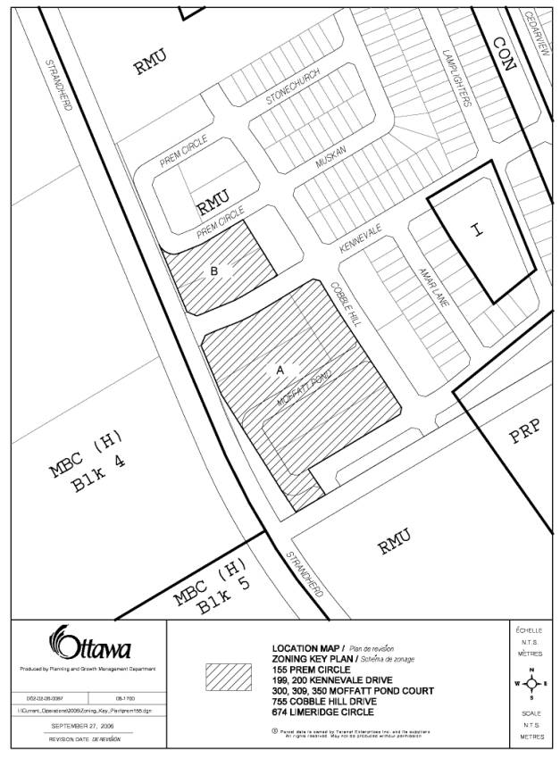
Document 1 Location
Map
Document 2 Details
of Recommended zoning
Document
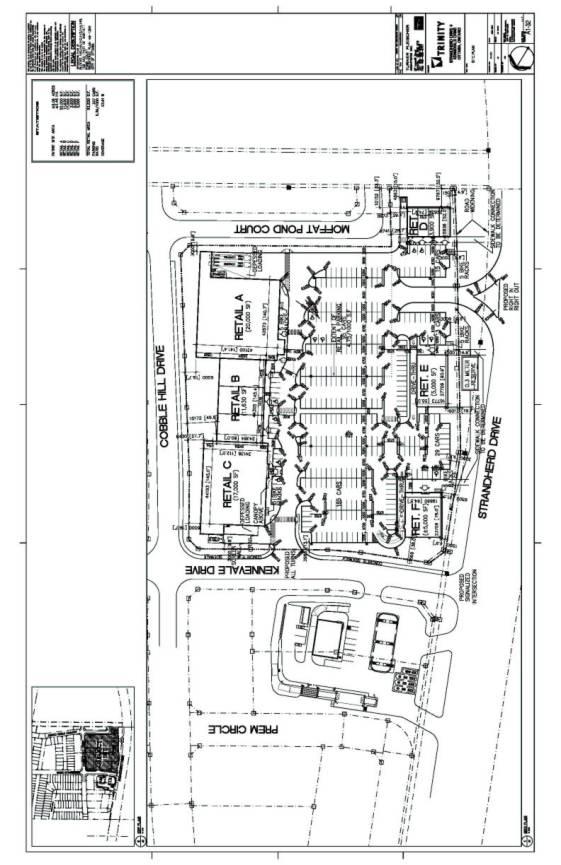
3 Conceptual Site Plan for Retail
Plaza and Gas Station
DISPOSITION
City Clerk’s Branch, Committee and Council
Services to notify the owner, DCR Phoenix Development Corporation, 18 Bentley
Ave. Ottawa. ON, applicant, Bill Holzman, 1076 Castle Hill Crescent, Ottawa,
ON., OttawaScene.com,
174 Colonnade Road, Unit #33, Ottawa, ON K2E 7J5, Ghislain Lamarche, Program Manager, Assessment,
Financial Services Branch (Mail Code:
26-76) of City Council’s decision.
Planning, Transit and the Environment
Department to prepare the implementing by-law, forward to Legal Services Branch
and undertake the statutory notification.
Legal Services Branch to forward the implementing
by-law to City Council.
LOCATION MAP DOCUMENT
1
DETAILS OF RECOMMENDED ZONING DOCUMENT
2
1. That the lands known municipally as 199 and 200 Kennevale Drive, 155 Prem Circle, 755 Cobble Hill Drive, 300, 309 and 350 Moffatt Pond Court and 674 Limeridge Circle, shown as Areas A and B in Document 1, be rezoned as follows:
Ÿ Area A from RMU to CC Block XX
Ÿ Area B from RMU to CA1 Block XX
2. Notwithstanding the permitted uses of Section 7:3:1 to the contrary, for the lands zoned as CC- Block XX, the following additional permitted use is allowed:
Ÿ Supermarket, for the sale of fresh and frozen foods.
3. Notwithstanding the zone provisions of subclause 5:20:11 i) and clause 7:3:2 to the contrary, for the lands zoned as CC - Block XX, the following provisions apply:
Ÿ Yard Front (Minimum) 1.0 metre
Ÿ Front Yard loading exemption from by-law restriction
- Notwithstanding the zone provisions of Section 7:3:2 to the contrary, for the lands zoned as CC- Block XX, the following maximum gross leasable floor area applies:
Ÿ Gross Leasable Floor Area (Maximum) 6,510 sq. m.
5. Notwithstanding the permitted uses of Section 7:8:1 to the contrary, for the lands zoned as CA1- Block XX, only the following uses are permitted:
Ÿ
Automobile service station
Ÿ
Convenience store, if accessory to an Automobile
service station
CONCEPTUAL RETAIL PLAZA AND GAS STATION SITE
PLAN DOCUMENT 3