Report to/Rapport au :
Planning and Environment Committee
Comité de l'urbanisme et de
l'environnement
30 January 2007/ le 30 janvier 2007
Submitted by/Soumis par : Nancy Schepers, Deputy City Manager/Directrice
municipale adjointe
Planning, Transit and the Environment/ Urbanisme,
Transport en commun et Environnement
Contact
Person/Personne Ressource : Grant Lindsay, Manager / Gestionnaire,
Development Approvals / Approbation des demandes d'aménagement
(613) 580-2424, Ext. 13242 Grant.Lindsay@ottawa.ca
|
SUBJECT: |
SITE PLAN CONTROL - 40 Cleary Avenue (FILE
NO. D07-12-06-0224) |
|
|
|
|
OBJET : |
REPORT RECOMMENDATION
That Planning and Environment Committee
approve the Site Plan Control application for 40 Cleary Avenue as shown on the
following plans:
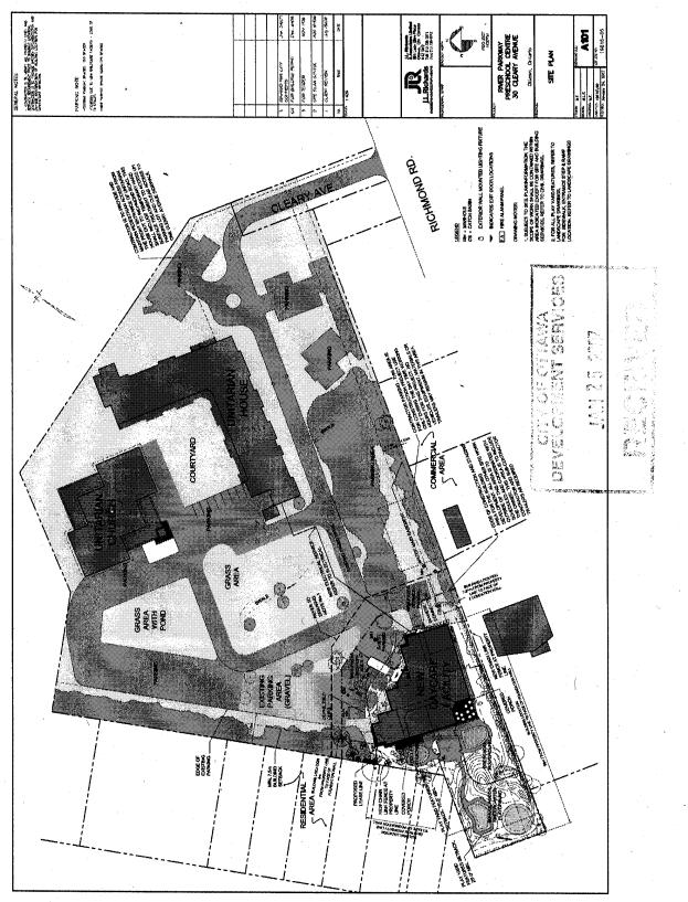
1. "Site Plan, River Parkway Preschool Centre, Drawing No. A101" prepared by J.L. Richards & Associates Limited, dated as revised to January 24, 2007, and dated as received by the City of Ottawa on January 25, 2007.
2. "River Parkway Preschool Centre,
Layout Plan, drawing number L.1", prepared by Douglas Associates,
Landscape Architects Ltd., dated November, 2006, revised to January 23, 2007,
and dated as
reviewed by Infrastructure Approvals Division on January 25, 2007.
3. "River
Parkway Preschool Centre, Landscape Plan, drawing number L-2", prepared by
Douglas Associates, Landscape Architects Ltd., dated November, 2006, revised to
January 23, 2007, and dated as received by the City of Ottawa on
January 25, 2007.
4. "River
Parkway Preschool Centre, Site Servicing Plan, Drawing No. S1", prepared
by J.L. Richards & Associates Limited, dated October 27, 2006, revised to
January 23, 2007, and dated as reviewed by Infrastructure Approvals Division
on January 25, 2007.
5. "River Parkway Preschool Centre,
Grading Plan, Drawing No. G1", prepared by J.L. Richards & Associates
Limited, dated May 4, 2006, revised to January 23, 2007, and dated as reviewed
by Infrastructure Approvals Division on January 25, 2007
6.
"River Parkway Preschool Centre, Plan and Profile,
Cleary Avenue, Drawing No. O1", prepared by J.L. Richards &
Associates Limited, dated May 4, 2006, revised to January 23, 2007, and dated
as reviewed by Infrastructure Approvals Division on January 25, 2007.
7. "River
Parkway Preschool Centre, Plan and Profile, Cleary Avenue, Drawing No.
O2", prepared by J.L. Richards & Associates Limited, dated May 4,
2006, revised to January 23, 2007, and dated as reviewed by
Infrastructure Approvals Division on January 25, 2007.
subject
to the conditions contained in Document 9.
RECOMMANDATION DU RAPPORT
Que le Comité de l'urbanisme et de
l'environnement approuve la demande de réglementation du plan d'implantation
visant le 40, avenue Cleary, qui est illustrée par les plans suivants :
1. Site Plan, River Parkway Preschool Centre,
Drawing No. A101 (Plan d'implantation, Centre préscolaire de la promenade de l'Outaouais,
dessin no A101), produit par J.L. Richards & Associates
Limited, révisé le 24 janvier 2007 et reçu à la Ville d'Ottawa le 25
janvier 2007;
2. River
Parkway Preschool Centre, Layout Plan, drawing number L.1 (Centre
préscolaire de la promenade de l'Outaouais, plan d'aménagement, dessin numéro
L.1), produit par Douglas Associates, Landscape Architects Ltd., daté de
novembre 2006, révisé le 23 janvier 2007 et examiné par la Division de
l'approbation des demandes d'infrastructue le 25 janvier 2007;
3. River
Parkway Preschool Centre, Landscape Plan, drawing number L-2 (Centre
préscolaire de la promenade de l'Outaouais, plan d'aménagement paysager, dessin
numéro L-2), produit par Douglas Associates, Landscape Architects Ltd., daté de
novembre 2006, révisé le 23 janvier 2007 et reçu à la Ville d'Ottawa le 25
janvier 2007;
4. River
Parkway Preschool Centre, Site Servicing Plan, Drawing No. S1
(Centre préscolaire de la promenade de l’Outaouais, plan de viabilisation,
dessin no S1), produit par J. L. Richards & Associates
Limited, daté du 27 octobre 2006, révisé le 23 janvier 2007 et
examiné par la Division de l’approbation des demandes d’infrastructure le 25
janvier 2007;
5. River
Parkway Preschool Centre, Grading Plan, Drawing No. G1
(Centre préscolaire de la promenade de l’Outaouais, plan de nivellement, dessin
no G1), produit par J.L. Richards & Associates Limited,
daté du 4 mai 2006, révisé le 23 janvier 2007 et examiné par la Division de
l’approbation des demandes d’infrastructure le 25 janvier 2007;
- River
Parkway Preschool Centre, Plan and Profile, Cleary Avenue, Drawing No. O1
(Centre préscolaire de la promenade de l’Outaouais, plan et profil, avenue
Cleary, dessin no O1), produit par J. L. Richards &
Associates Limited, daté du 4 mai 2006, révisé le 23 janvier 2007 et
examiné par la Division de l’approbation des demandes d’infrastructure le
25 janvier 2007;
- River
Parkway Preschool Centre, Plan and Profile, Cleary Avenue, Drawing No. O2
(Centre préscolaire de la promenade de l’Outaouais, plan et profil, avenue
Cleary, dessin no O2), produit par J. L. Richards &
Associates Limited, daté du 4 mai 2006, révisé le 23 janvier 2007 et
examiné par la Division de l’approbation des demandes d’infrastructure le
25 janvier 2007;
sous
réserve des conditions énoncées au Document 9.
BACKGROUND
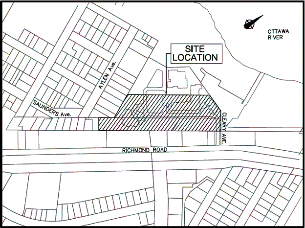
The subject property is known as 40 Cleary Avenue, which is the First Unitarian campus at the north end of Cleary Avenue. The actual development site is an area leased to the River Parkway Preschool Centre at the southwest corner of the First Unitarian campus. The overall property has an area of 2.069 hectares and is occupied by the Unitarian Church on the northeast corner of the property and the Unitarian House seniors residence on the southeast portion of the property. The church structure also currently houses a pre-school facility in the basement. Site access is provided by an on-site roadway across the south side of the property linking to the terminus of Cleary Avenue at the southeast corner of the property. There are parking areas on the south and west portions of the site. There are trees and other landscaping around the perimeter and within the interior of the site. Adjacent to the north and east of the campus is part of the National Capital Commission's Ottawa River Parkway. To the west is a low profile residential area, consisting primarily of single detached dwellings. To the south is the rear side of low profile commercial buildings and parking areas that front onto Richmond Road.
The
proposed development will consist of a one and one-half storey, 1,066
square-metre daycare building, containing six play/class rooms, administration,
storage, food preparation and utility rooms, and a second storey mezzanine
level storage area. The facility is
designed to accommodate approximately 93 children, ranging from toddlers to
elementary school aged, and is intended to replace the existing pre-school
facility located in the church structure, which accommodates approximately 89
children.
The
proposal includes the provision of 11 parking spaces plus one service parking
area to serve staff and clients, along the north and east sides of the
building. The total number of parking
spaces on the site is proposed to decrease to a total of 174; a total of 143
parking spaces are required by the Zoning By-law. Three play areas designed to suit the specific needs of
different age groups will be provided behind the building (west side) in a
small "pan-handle" shaped segment of the site at the southwest corner
of the property. A number of trees and
shrubs will be retained at the edge of the property and will be supplemented by
new trees and shrubs, as well as continuous combination of fencing and hedging
adjacent to the neighbouring residential properties.
Removal
of Delegated Approval Authority
Delegated authority for approval of this application was removed from staff, in keeping with Council policy, by an e-mail message sent to staff by Councillor Cullen stating that members of the community had cited concerns about the project. Community concerns are discussed in Document 10.
DISCUSSION
Site Design Concept
The site design concept sensitively addresses the surrounding urban context, while providing for efficient and functional use of the Unitarian campus and maintaining sufficient space for logical future expansion of other facilities on the campus. The southwest corner siting of the proposed building provides efficient access, using the existing on-site roadway system connection to the end of Cleary Avenue, and provides increased separation of the existing and proposed parking facilities from the nearby residential neighbourhood to the west. No noticeable increase in parking demand is anticipated given that the daycare is relocating on the same site. This location also allows for maximizing the use of the unusual “pan-handle” shaped portion of the campus for the varied play areas required by a modern children’s daycare facility. The design concept also affords the retention and relocation of significant segments of the existing vegetation on the site; the vegetation is used to provide diversity and shade to play areas, help achieve a buffer from adjacent residences, and maintain separation from the commercial development lands adjacent to the south. The low profile building design will help provide visual compatibility between the new development and the adjacent residential community to the west.
Official Plan Policies
Strategic Directions
The
Strategic Directions Section of the Official Plan (OP) advocates creating
livable communities, by providing a balance of facilities, including schools
and community facilities. The proposed
site plan provides for a continued provision of a daycare facility to serve the
community.
Compatibility and
Community Design
In addition to the design merits discussed
above, the proposed site plan is consistent with the intent of the Design
Objectives and the Principles of the Compatibility and Community Design
sub-section of the Strategic Directions of the OP.
The proposed development is consistent with the
compatibility factors of sub-section 2.5.1 which pertain to: creating places
with their own identity; defining quality public and private spaces; creating
places that are safe and accessible; respecting the character of the existing
area; giving consideration to the ease of adaptability over time; and
respecting natural processes and features and promoting environmental
sustainability. The development,
through its location and building design on the Unitarian campus, will contribute
to the creation of the campus as a distinctive place with sensitivity to its
local neighbourhood setting through the design and scale, of the low profile
building and the landscape treatment. The now vacant and over-grown southwest
segment of the campus will benefit from the development becoming safer, less
isolated, and benefiting from the passive surveillance of constant use. The site plan concept, with the building in
the southwest corner, will allow for future adaptation of the overall site for
other possible community facilities.
The retention and relocation of a number of existing trees, supplemented
by new plantings will respect the natural vegetative features of the site.
Compatibility is also addressed in sub-section
4.11 of the OP. The policies of
sub-section 4.11 applicable to the evaluation of the subject site plan pertain
to factors of: traffic, vehicular access, parking, building height and mass,
outdoor amenity areas, loading and service areas, lighting, noise, and
supporting neighbourhood services. As
discussed above the site design concept appropriately addresses traffic,
vehicular access, parking, and building height and mass issues. The site plan includes a combination of
fences and hedge plantings to provide privacy and noise buffering between the
proposed play areas and adjacent residential private amenity spaces. Loading and servicing is at the southeast
corner of the building out of view from the adjacent neigbourhood and from the
predominant on-site views from the senior’s residence. Site lighting will be limited to entrance
areas and will add to heightened security in the area. The daycare centre provides a service to
support the needs of the neighbourhood.
General Urban Area
The Designations and Land Use Section of the OP
establishes the site as part of the General Urban Area. The policies for the General Urban Area
provide for the inclusion of service and institutional facilities, such as
daycare centres, to help facilitate the development of complete and sustainable
communities.
Servicing
The policies for water and wastewater servicing require that there is a reliable water supply and safe wastewater disposal available to all development. There is adequate piped sewer services available to accommodate redevelopment at the subject location as proposed, and the applicant is upgrading the overall water service to the campus as part of this development. The proposal will also be required to satisfy objectives for proper stormwater management related to a new development.
Conclusion
The proposed site plan has been
evaluated in terms of the existing zoning of the property, the site design
concept and the intent of the Official Plan, and subject to the conditions
contained in Document 9, the Department is recommending approval of the
application.
CONSULTATION
Notice of this applicaton was carried out in accordance with the City's Public Notification and Consultation Policy. The Ward Councillor is aware of this application and the staff recommendation. Comments were received from the public regarding this application, as well as comments received from the two meetings, attended by staff, that were held by the Ward Councillor with neighbours. The community identified the following as the primary issues of concern: (1) noise; (2) loss of privacy; and (3) loss of existing vegetation. Detailed responses to the notification/circulation are provided in Document 10.
FINANCIAL IMPLICATIONS
APPLICATION PROCESS TIMELINE STATUS
The application was not processed by the "On Time Decision Date" established for the processing of Site Plan Control applications in which Delegation of Authority to the Director of Planning and Infrastructure Approvals is removed, due to the need to resolve community concerns.
SUPPORTING DOCUMENTATION
Document 4 –
Landscape Plan 2
Document 5 –
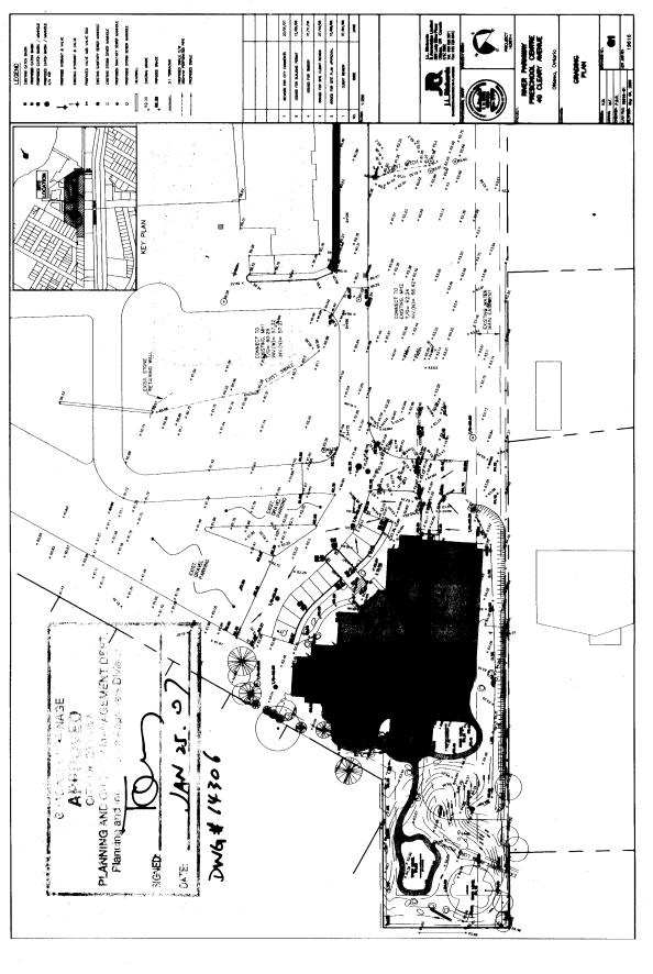
Servicing Plan
Document 6 –
Grading Plan
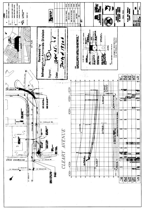
Document 7
– Cleary Avenue Plan and Profile – 1
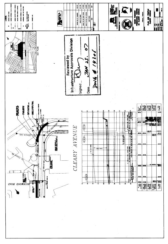
Document 8
– Cleary Avenue Plan and Profile – 2
Document 9 - Conditions of Site Plan
Control Approval
Document 10 - Consultation Details
DISPOSITION
Corporate Services Department, Legal Services Branch to prepare the Site Plan Control agreement.
Planning Transit and the Environment Department
to notify the owner, (The First Unitarian Congregation of Ottawa, 30 Cleary
Avenue, Ottawa, K2A 4A1); applicant, (J.L. Richards & Associates Limited,
864 Lady Ellen Place, Ottawa, K1Z 5M2); OttawaScene Canada, 33‑174 Colonnade
Road, Ottawa, ON, K2E 7J5; and all interested parties of Planning and
Environment Committee’s decision.
LOCATION MAP DOCUMENT
1
SITE PLAN DOCUMENT
2
LANDSCAPE PLAN 1 DOCUMENT
3
LANDSCAPE PLAN 2 DOCUMENT
4
SERVICING PLAN DOCUMENT
5

GRADING PLAN DOCUMENT
6
CLEARY AVENUE PLAN AND PROFILE -1 DOCUMENT
7
CLEARY AVENUE PLAN AND PROFILE -2 DOCUMENT
8
CONDITIONS OF SITE
PLAN CONTROL APPROVAL DOCUMENT 9
STANDARD CONDITIONS
1.
Permits
The Owner(s) shall obtain such permits as may be required from Municipal
or Provincial authorities and shall file copies thereof with the Director,
Planning and Infrastructure Approvals Branch.
2.
Barrier Curbs
The Owner(s) agrees that the parking areas (and entrances) shall have barrier curbs and shall be constructed in accordance with a design professional and approved by the Director, Planning and Infrastructure Approvals.
3.
Water Supply for Fire Fighting
The Owner(s) shall provide adequate water supply for fire fighting for every building. Water supplies may be public water works system, automatic fire pumps, and pressure tanks for gravity tanks.
4. Reinstatement of
City Property
The Owner(s) shall reinstate at its expense, to the satisfaction of the Director of Planning and Infrastructure Approvals, any property of the City, including, but not limited to, sidewalks and curbs, boulevards, that are damaged as a result of the subject development.
5. Construction
Fencing
The Owner(s) shall be required to install construction fencing at its expense, in such a location as may be determined by the Director of Planning and Infrastructure Approvals.
6.
Completion of Works
No building will
be occupied on the lands, nor will the Owner(s) convey title to any building
until all requirements with respect to completion of the Works as identified in
this Agreement have been carried out and received Approval by the Director,
Infrastructure Services, including the installation of municipal numbering
provided in a permanent location visible during both day and night and the
installation of any street name sign on relevant streets. Notwithstanding the
non-completion of the foregoing Works, conveyance and/or occupancy of a lot or
structure may otherwise be permitted, if in the sole opinion of the Director,
Planning and Infrastructure Approvals, the aforesaid Works are proceeding
satisfactorily toward completion. The
Owner shall obtain the consent of the Director, Planning and Infrastructure
Approvals for such conveyance and/or occupancy in writing.
SPECIAL CONDITIONS
1. Permanent Features
No permanent features will be permitted above and below-grade within City’s easement.
2. Re-grading
Shoulders of Ditch
The Owner(s) must:
(a)
Re‑grade
the shoulders of the ditch found on the road allowance abutting the site to be
developed;
(b)
Obtain
utility clearances prior to the re-grading of ditches;
(c)
Obtain the
approval of the Public Works and Services Department if the grade of the ditch
bottoms are to change; and
(d)
Maintain a
grass cover as required by the By‑law Regulating the Use and Care of
Streets (By‑law Number 165‑73, as amended).
3. Asphalt Overlay
The Owner(s) must install an asphalt overlay over the total area of the public driving surface fronting the site, because of the number of road cuts required to provide utility services to the development, to the satisfaction of the Deputy City Manager, Public Works and Services Department All cost(s) are to be borne by the Owner(s).
4. Bird
Nesting Protection
The owner agrees to make best efforts
to avoid the removal of vegetation from the site during bird nesting season
between April 1 and July 31.
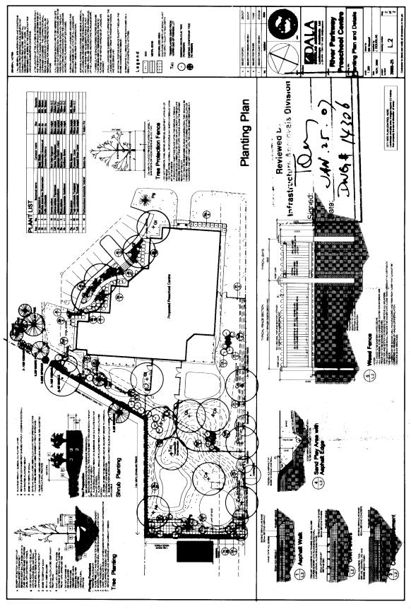
5. Tree Protection
In addition to the provisions of Condition 22 of Schedule “C”, the Owner(s) must undertake protective measures to the satisfaction of the Director, Planning and Infrastructure Approvals prior to commencement of, and during construction, to minimize damage to any roots, trunks and branches of the existing trees, which are to remain and be protected as shown on the approved landscape plans. These measures shall consist of the following:
i. Erect a wooden tree protection fence having
a minimum height of 1.2 metres as shown on the approved “Planting Plan and
Details, drawing number L.2” to clearly delineate the area to be protected and
to minimize any damage, including any damage to tree roots. The barrier shall be erected prior to any
site preparation and shall remain in place until such time as final grading has
been completed to the satisfaction of the Deputy City Manager, Planning,
Transit and the Environment.
ii. No
heavy equipment or vehicles will be permitted within the wood barrier protecting the existing tree to be
retained.
6. Native Plant Selections
Proposed vegetation shown
on the approved “Landscape Plan, drawing no. L.2” may be changed to
native species of similar size and type (deciduous or coniferous) at the
discretion of the Landscape Architect.
CONSULTATION DETAILS DOCUMENT
10
NOTIFICATION AND CONSULTATION PROCESS
Notification and public consultation
was undertaken in accordance with the Public Notification and Public
Consultation Policy approved by City Council for Site Plan applications. Staff also attended two meetings in the community.
PUBLIC COMMENTS
SUMMARY OF PUBLIC INPUT
The issues raised by respondents to the public notification and at the meetings with neighbours to the property are summarized and addressed below:
1.
Comment:
The proposed play areas are too close to the adjacent private rear yards
of neighbouring residences and should be buffered for privacy and noise.
Response:
The plan has been revised to add wooden screen fencing for privacy and
improved sound attenuation along the most westerly edge of the site.
2.
Comment:
Trees along the south side of the site should be saved as much as
possible to help screen the site and adjacent residential rear yards from the
nearby Richmond Road commercial properties.
Protection measures should be installed for trees to be saved.
Response:
Special Condition 5 addresses tree protection, and the plan has been
revised to save more trees along the south edge of the property and to by
adding three new trees, while maintaining City drainage requirements in this
area.
3.
Comment:
More trees should be saved along the west side of the project in keeping
with an understanding between the Unitarian Church and adjacent neighbours that
a minimum 40 foot wide landscape buffer will be maintained in this area.
Response: The plan has been revised to save more trees
along the west side of the property.
There is no evidence of a legally binding agreement between the church
and neighbouring property owners establishing set backs, and the proposal
exceeds the Zoning By-law set back requirements in this area.
4. Comment: The proposal will lead to a devaluation of
local property values. Any problems
associated with the proposed development should be borne by the church
congregation not the adjacent resident neighbours.
Response:
Staff is unaware of any
evidence concluding that the proposed daycare development will cause diminished
property values.
5. Comment: As a resident of property abutting the
church land and a parent of a child attending the daycare this facility is
welcome to our community and there appears to be ways to mitigate all the
neighbours’ concerns.
Response: The proposed plan has been revised to mitigate neighbours concerns as
much as practicable.
6. Comment: The church should make sure
that the road system is properly reinstated after the excavation and
construction of the water and/or sewer lines.
Response: The
conditions of approval require proper reinstatement of all private and public
roadways affected by the proposed construction.
COUNCILLOR’S COMMENTS
Councillor Alex Cullen has indicated support for the application.
COMMUNITY ORGANIZATION COMMENTS
Community Association Comments
Comments received from the public, as summarized and addressed above, indicated that the concerns raised were supported by the Woodroffe North Community Association (WNCA).
There was not formal response from the WNCA per se.
ADVISORY COMMITTEE COMMENTS
Ottawa Forests and Greenspace Advisory Committee
“Significant trees on the site that should be preserved
However
“TRANSPLANTING” will involve 7 gingkos, 2 spruce, a pine, a honey locust, and 3
red oaks, and a large number of shrubs including red osier dogwood, yellow twig
dogwood, Japanese garden juniper, alpine currant, elderberry, spirea, and 92
cedars . This would actually appear to be new planting rather than
transplanting.. Of these, the Ginko,
Spruce? Pine? Honey Locust, Japanese Garden Yew, Alpine Current, Spirea? Are
not native to the Ottawa area. OFGAC
recommends the use of native species and a table below suggests alternatives to
these if they are new plantings.
Need for
tree or greenspace protection
during post development phase
Most of the
space will be used for the building or planted to new trees and shrubs. However normal precautions should be taken
to protect the trees that will not be moved (fencing out to the dripline, no
parking of vehicles under existing trees nor storage of construction
equipment). Newly planted trees and shrubs should also be protected.
Comments on the Site Plan
The site is
conscientiously planned and transplanting would compensate for the necessary
tree destruction. The site is flat and currently mainly either grassland or
parking space
The plan
indicates that retention of existing trees is difficult, but the”
transplanting” intentions should compensate.
None of the existing trees is very large.
|
Proposed
planting of Non-native Species |
OFGAC’s
Proposed Alternative Native Species |
||
|
Common
Name |
Botanical
Name |
Common Name |
Botanical Name |
|
Ginko |
Ginko
biloba |
Grey
Birch |
Betula
populifolia |
|
Honey
Locust |
Gleditsia
tricanthos |
Downy
Serviceberry |
Amelanchier
arborea |
|
Japanese
Garden Yew |
Juniperus
procumbens |
Common
Juniper |
Juniperus
communis |
|
Alpine
Current |
Ribes
alpinum |
Winterberry |
Ilex
verticillata |
|
Snowmound
Spirea |
Spiraea
nipponica |
Narrow-leaved
Meadowsweet |
Spiraea
alba |
Recommendation
Accessibility Advisory Committee
“It appears that this developer has
taken care to ensure easy access to the facility by the mobility impaired. There are no grade separations at entry
points and a ramp has been provided to access the main entrance from the
accessible parking stall.
We trust
that this stall will be of the required width and that pushbuttons will be
provided at the main entrance for ease of access.”
Response to
Comments
The
accessible parking stall will meet the dimensional requirements of the City,
and main building entrance will have “pushbuttons” required to satisfy the
accessibility requirements of the Ontario Building Code.