Report to/Rapport au :
Planning and Environment Committee
Comité de l'urbanisme et de
l'environnement
28 June 2006 / le 28 juin 2006
Submitted by/Soumis par : John
L. Moser, Acting Deputy City Manager/
Directeur municipal adjoint par interim,
Planning and Growth Management/Urbanisme et Gestion de la croissance
Contact
Person/Personne ressource : Richard Kilstrom, Manager
Planning, Environment and Infrastructure
Policy/Politiques d’urbanisme, d’environnement et d’infrastructure
(613) 580-2424 x 22653,
Richard.Kilstrom@Ottawa.ca
|
|
Ref N°: ACS2006-PGM-POL-0062
|
|
SUBJECT:
|
FERNBANK COMMUNITY DESIGN PLAN - TERMS OF
REFERENCe
|
|
|
|
|
OBJET :
|
PLAN DE CONCEPTION
COMMUNAUTAIRE POUR FERNBANK - PARAMÈTRES
|
REPORT RECOMMENDATION
That Planning and Environment Committee approve the
Terms of Reference for the Fernbank Community Design Plan, as shown in Document
1, to guide the project in consultation with the community, area landowners,
and other interested parties.
RECOMMANDATION DU
RAPPORT
Que le Comité de l’urbanisme et de
l'environnement approuve les paramètres du plan de conception communautaire
pour Fernbank, tel qu'illustrés dans le Document 1, dans le but d'orienter la
consultation avec la collectivité, les propriétaires fonciers du secteur et
autres groupes intéressés.
BACKGROUND
In August 2005, the Ontario Municipal Board allowed
appeals by Del, Brookfield and West Park Estates to designate their lands
between Stittsville and Kanata as urban in the 1997 Regional Official Plan. In
Order 2092, the Board requested that a modification to the 1997 Plan be
prepared to guide future development of the area according to policies similar
to those in the 2003 Ottawa Official Plan regarding community design
plans. Recognizing that the designation
of the area was also appealed in the 2003 Official Plan, Council subsequently
settled the 2003 Plan appeals by supporting a Future Urban designation for the
area in the 2003 Plan and setting additional requirements for the community
design plan. At its meeting on November
9, 2005, Council adopted motions that, among other matters, required that
planning for the area also consider the phasing of infrastructure, provision of
recreation and public amenities, and financing.
The purpose of this report is to present the Terms of Reference for
the Fernbank Community Design Plan for approval by Planning and Environment
Committee.
DISCUSSION
The Terms of Reference are proposed to guide a
community design plan for a study area shown on Document 2 (attached) north of
Fernbank Road between Stittsville and Kanata.
The purpose of the community design plan is to implement the policies of
the Official Plan, particularly with reference to the policies of Section 3.6.4
on Developing Communities. Of the total study area of approximately 650 ha,
approximately 455 ha are owned by Del, Brookfield and WestPark Estates. These
landowners are sponsoring the community design plan and are paying all the
costs associated with it and the environmental assessments. The remaining lands
include approximately 132 ha designated as Agriculture Resource in the
northeast portion of the study area that are now entirely surrounded by urban
land, and approximately 60 ha in the southwest portion of the study area that
are designated as General Rural. The
designation of the latter site was appealed to the Ontario Municipal Board
after the 2003 Official Plan was approved by the Ministry of Municipal Affairs
and Housing and is scheduled for a Board hearing in September.
Inclusion of these additional lands in the study area for the
community design plan allows for efficient planning of public services for the
long term. Given the proximity of these
lands to the urban area, it is reasonable to anticipate that they will be
designated as part of the urban area by an Ottawa Council at some point in the
future. The future use of these lands
will be broadly determined in the community design plan, to a level of detail
sufficient to support analysis of requirements for transportation, water and
sewer services and consideration of alternate development patterns and
servicing scenarios. Stormwater management scenarios can be evaluated and
environmental effects of development of the whole area can be reasonably
assessed. However, the need to
designate the additional lands and any other lands in the city as urban will be
assessed as part of a separate process leading to a Council decision on the
urban land supply early in 2008, in keeping with Council's policy to consider
the need for urban land on a comprehensive basis every five years.
The Terms of Reference proposes a planning process that coordinates
the Municipal Class Environmental Assessment for the required infrastructure
with approval of an Official Plan amendment under the Planning Act. Provided that
the intent and requirements of both the Municipal Class Environmental
Assessment process and the Planning Act process are fulfilled, the projects
identified through the environmental assessment are considered pre-approved
once an Official Plan Amendment based on the community design plan is
approved. Appeals of either the Class
EA projects or the Official Plan Amendment would be to the Ontario Municipal
Board. This approach has the advantage
of providing a more comprehensive approach to infrastructure and land use
planning and helps incorporate mitigation measures in the development
plan. The public is also provided a
more comprehensive picture of the proposed development and the implications of
various development scenarios.
However, coordination of the two processes can be technically
challenging and therefore, the City staff and the landowners sponsoring the
community design plan are working closely with the Ministry of Environment,
Ministry of Natural Resources, and Ministry of Transportation. These ministries have been consulted on the
Terms of Reference and the work program requires ongoing consultation.
The community design plan will be a cooperative undertaking by the
City and the sponsoring landowners, Del, Brookfield Homes and WestPark Estates,
with the two serving as co‑proponents of the Class EAs. City staff, the sponsoring landowners, and
their consultants will form the core project team, which in turn works
throughout the project with a Technical Advisory Committee, comprised of government
agencies and City staff from various departments, and a Public Advisory
Group. The Public Advisory Group, to be
selected in consultation with the area Councillors, will include organizations
such as community associations and recreation clubs based in the adjacent
communities as well as environmental groups and other special interest groups
that are interested in participating.
Council's Advisory Committees will be consulted during the study and
requested to comment.
In keeping with the Council motion that the community design plan
consider the advancement of public amenities, such as sportsfields, parks and
community centres, a parks and recreation planner will participate throughout
the process. In addition, City staff
will coordinate a review of community and protective services in the west to
make sure the population growth arising from development of these lands, Kanata
West and other new residential lands has been accommodated.
The study process will yield a community design plan plus supporting
documents, including a Transportation Master Plan, Infrastructure/Servicing
Master Plan, and Cultural Heritage and Environmental Management Plan, including
a Carp River Restoration Plan if warranted.
The supporting documents will be prepared to a level of detail normally
provided for Environmental Study Reports prepared in support of Municipal Class
EA projects. Further, the community
design plan will advise on the need to adjust the phasing of infrastructure in
the City's master plans for transportation and infrastructure, to accommodate
the new development, and front-end financing will be considered.
ENVIRONMENTAL
IMPLICATIONS
The study area straddles two watersheds, the Carp
River and the Jock River. The Terms of
Reference recognizes the need to incorporate the findings of the Carp River
Watershed/Subwatershed Study and the background inventory of the Jock River
Subwatershed Study (Reach 2) into the Environmental Management Plan. Off-site impacts will also be identified and
addressed appropriately.
RURAL IMPLICATIONS
The change in designation of formerly rural lands and
the shift in the urban boundary was determined by the Ontario Municipal Board
in 2005. Thus, this report has no rural
implications.
CONSULTATION
The Terms of Reference were drafted in consultation
with area councillors, the conservation authorities and various provincial
ministries. Copies of the proposed Terms of Reference and information about
this report to Planning and Environment Committee were provided to all
landowners in the study area. In
addition, all technical agencies and community groups who are circulated on
development applications in the area were advised of this report, as a means of
giving early notice that the study was being initiated. This report was also
listed in the newspaper notices published for the July 11 meeting. The Terms of Reference provide for public
consultation as the study progresses.
FINANCIAL IMPLICATIONS
This report has no financial implications. The sponsoring landowners are paying the
cost of the community design plan and the environmental assessments and will
not request compensation through the Development Charges Act.
SUPPORTING DOCUMENTATION
Document 1 Fernbank
Community Design Plan - Terms of Reference
Document
2 Study Area
DISPOSITION
Planning and Growth Management be directed to
initiate the Fernbank Community Design Plan, in keeping with its Terms of
Reference.
DOCUMENT 1
FERNBANK COMMUNITY DESIGN PLAN –
TERMS OF REFERENCE
Fernbank Community Design
Plan
TERMS OF
REFERENCE
June 27,
2006
Brookfield
Homes (Ontario) Limited ◘ 443641 Ontario Limited (Del Corporation Ltd.)
◘ WestPark
The Fernbank Community is proposed
to encompass approximately 650 hectares (1,600 acres) of land between the
established communities of Stittsville, Kanata West and Kanata South, extending
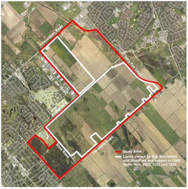
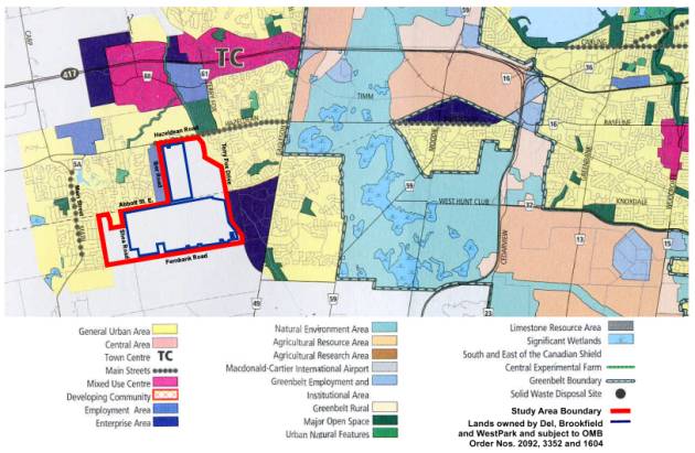
south to Fernbank Road, within the West Urban Area of the City of Ottawa. The Fernbank Community Study Area is shown
on Figures 1 and 2 (the “Study Area”).
Figure 1: City of Ottawa Official Plan –
Schedule B
At the request of the
three major landowners in the Study Area, (Brookfield Homes (Ontario) Limited,
Del Corporation and WestPark, collectively the “Sponsoring Landowners”) the
City of Ottawa is supporting the initiation of the Fernbank Community Design
Plan (“CDP”) process, generally as outlined herein.
The Study Area includes
approximately 455 hectares (1,125 acres) of land owned by Brookfield Homes
(Ontario) Limited, Del Corporation and WestPark (“Brookfield”, “Del” and
“WestPark”) and additional lands to extend the Study Area north to Hazeldean
Road, east to the Carp River, west to the existing Urban Area of Stittsville
and south to Fernbank Road, which is to function as an Urban Area boundary to
protect productive agricultural areas to the south on the Richmond Plain.
Figure 2: Study Area

The Brookfield, Del & WestPark
lands were the subject of an Ontario Municipal Board (“OMB”) hearing during the
summer of 2005 which involved proposed amendments to the former Region of
Ottawa-Carleton Official Plan (“Regional Plan”) to redesignate lands for urban
uses. As directed by OMB Order No.
2092, issued August 11, 2005, Order No. 3352, issued December 11, 2005, and
Order No. 1604, issued May 31, 2006, the Regional Plan and the City of Ottawa
Official Plan are to be respectively amended to redesignate the Brookfield, Del
and WestPark lands as “General Urban – Special Policy Area” and “Future Urban
Area”, and to include these lands within the Urban Area Boundary. The lands subject to OMB Order Nos. 2092,
3352 and 1604 are also shown on Figures 1 and 2. When the OMB issues its final order on the Fernbank lands, the
small holdings between Terry Fox Drive and Shea Road, adjacent to Fernbank
Road, will be included in the urban area.
The proposed Study Area encompasses
the entire area between Stittsville and Kanata extending from Hazeldean Road
south to Fernbank Road which includes lands that were not approved as ‘General
Urban – Special Policy Area” and “Future Urban Area” in the OMB’s decision. The OMB concurred with the evidence that
future planning studies (such as those described herein) address the whole of
the area to the north of Fernbank Road and indicated that it could support an
urban designation for the whole area. However,
the determination as to if and when these other lands within the Study Area are
included within the designated urban area will be a matter subsequently
determined by City Council.
Order No. 3352 also directs that
community design plans for the lands designated as Future Urban Area shall, in
addition to the requirements described in Section 3.6.4 of the Official Plan,
address the phasing of the north-south arterial road capacity; the need to
advance the timing of infrastructure identified in Council’s master plans; the
provision of recreation and other amenities; the use of front-ending financing;
and, measures to ensure that existing local infrastructure is not
overburdened.
The OMB Order also
reflects Council’s motion of November 9, 2005, which provided direction on the
preparation of the Fernbank CDP. These
included the integration and design of the new north-south arterial to
accommodate development within the study area, the preparation of a final
phasing plan, examination of infrastructure and public amenity requirements and
the ability to advance their construction through front-end financing.
Both the “General Urban – Special
Policy Area” and “Future Urban Area” land use policies provide a shared general
policy direction for the preparation of the Fernbank CDP, prior to other development
approvals, as expressed in Section 3.6.4 of the Official Plan. This includes:
<
Establish
the mix and location of residential dwelling types for the area, of which no
more than 60 per cent shall be single-detached and semi-detached, and, at least
10 per cent shall be apartment dwellings and the remainder multiple dwellings,
other than apartments;
<
Establish an
overall average density for single-detached, semi-detached and townhouses of 29
units per net hectare;
<
Identify how the land use mix contributes to
achieving the balance of jobs and households for the larger area;
<
Establish an
overall mix and location of other land uses such as recreational, commercial
and institutional;
<
Complete a subwatershed plan should no plan
exist for the area;
<
Establish a modified grid system as the
preferred alignment of roads serving the area, in order to maximize the number
of access and egress points, the permeability of the network, pedestrian and
transit accessibility to all areas, and to enhance way-finding and personal
navigation within it;
<
Preserve existing desirable landform or
landscape features;
<
Identify and
illustrate how the development pattern will achieve a distinctive identity and
a variety of building form and façade treatments;
<
Establish policies for Hazeldean Road that provide
for a mix of uses that have the potential to evolve, over time, into more
compact, pedestrian-oriented and transit friendly places, considering Arterial
Main Street Design Guidelines and in keeping with Council policies already approved
for development fronting on this roadway.
A key consideration
throughout the Fernbank CDP process will be the various subwatershed studies.
The results of the Carp River Watershed/Subwatershed Study will also provide
essential input into the preparation of the CDP. At this time, preparation of the Reach Two Jock River
Subwatershed Study has been initiated, but only the Existing Conditions Report
having been prepared. The watershed analysis relating to the Fernbank CDP
process is to be integrated with any on-going watershed studies or study
updates and the Master Plans associated with the Environmental Assessments
required for the Study Area.
These Terms of Reference
are intended to provide information regarding the following components of the
Fernbank CDP, including:
·
Study Area Boundaries (Including the lands subject to OMB Order Nos.
2092 and 3352 and other lands in proximity which provide a logical and
comprehensive area for evaluation)
·
CDP Purpose and Objective
·
CDP Organization
·
Environmental Assessment
·
Work Program and Deliverables
These Terms of Reference
also represent the commencement of a process that will provide an excellent
opportunity for the residents of the City of Ottawa, including the immediate
surrounding communities of Kanata South, Stittsville and Kanata West, to
contribute to a collaborative community design process and to forge
partnerships with the City of Ottawa and area landowners. Input from stakeholders will be balanced and
shaped in accordance with the approved goals, objectives and policy directives
of the City of Ottawa Official Plan.
As is illustrated in Figure 2, the
Study Area for the Fernbank CDP is limited to those lands designated as Future
Urban Area, General Rural Area and Agricultural Resource Area in the new City
of Ottawa Official Plan, located south of Hazeldean Road, east of the existing,
designated urban area of Stittsville, west of the Carp River and the Terry Fox
Drive Extension and, north of Fernbank Road.
The Study Area comprises approximately 650 hectares (1,600 acres).
Background studies for the CDP and
Environmental Assessment processes will ensure that the lands located within
the Study Area are reviewed strategically by:
·
The identification of possible future transportation, recreational,
community infrastructure and servicing linkages to the Study Area and abutting
communities;
·
The identification of environmental features and constraints to ensure
that the aforementioned linkage locations do not adversely impact significant
environmental features;
·
The identification of significant cultural and heritage attributes; and,
·
An assessment of the potential impact of existing and future land use
activities on the affected subwatershed systems.
The study area has been expanded to
include lands surrounded by urban development.
It is anticipated that these lands will eventually be developed for
urban purposes. The time horizon is not known at this time, however this plan
and the infrastructure required to support the CDP will provide for eventual
integration of these lands into the urban area.
The Fernbank CDP process
represents an important opportunity to shape future development and land use in
a manner that fulfills and implements the key goals, objectives and policies of
the City of Ottawa Official Plan, including those pertaining to growth
management and Developing Communities, within a framework that carefully
considers the character of existing and planned adjacent communities.
The Fernbank CDP is to be
prepared in accordance with the policy requirements of Section 3.6.4 of the
Official Plan, and address the additional Study Area-specific matters as
outlined in OMB Order No. 3352, and as described in the Background section of
these Terms of Reference. In general,
the Fernbank CDP is intended to establish the mix, location and types of land
uses within the Study Area in accordance with good land use planning and
community design principles and infrastructure requirements.
The objective
of the CDP is to create a blueprint, which will help shape the Fernbank
Community as a very liveable community, with a land use plan, a parks and
recreation plan, an open space plan, an infrastructure plan, and design
guidelines. The CDP preparation process
will be integrated with Environmental Assessment processes for required
infrastructure within the Study Area.
The approved CDP will be the basis for an Official Plan Amendment (OPA)
under the Planning Act encompassing
the entire Fernbank Study Area. The following sections will provide the steps
for the OPA and indicate how the Class EA requirements will be integrated with
the actual OPA.
The Fernbank CDP will be
completed within an overall planning framework, which considers the following
on-going projects and plans:
·
Carp River Watershed/Subwatershed Study;
·
Jock River Subwatershed Study (Reach 2), as available;
·
Greenspace Master Plan;
·
Urban Natural Areas Environmental Evaluation Study;
·
Transportation Master Plan;
·
Infrastructure Master Plans;
·
Stormwater Management Strategy (Master Plan);
·
Hazeldean Road Widening/Huntmar Road Extension/ Fernbank Road
Widening/Terry Fox Drive Extension Environmental Assessments;
·
Ottawa Cycling Plan;
·
Pathway Network for Canada's Capital Region (Update);
·
East-West LRT Corridor Environmental Assessment;
·
Urban Design Guidelines (Annex 3 to the Official Plan);
·
Sports Fields Strategy;
·
Recreation Infrastructure Strategy; and,
·
Carp River, Poole Creek and Feedmill Creek Restoration Environmental
Screening Report (2006).
In parallel with the
Fernbank CDP, City staff will review the need for community services in the
Fernbank and surrounding area, to ensure that existing community services are
not over-burdened and that provision is made for future growth.
The Fernbank CDP is a
developer-initiated and funded project, however, the City of Ottawa remains the
key stakeholder and provides the regulatory framework within which the CDP will
be completed. The costs associated with the Fernbank CDP study process will be
borne by the Sponsoring Landowners.
CDP
Study Team Organization
The organization of the
Fernbank CDP Community Design Plan will include a number of committees or teams
to enable a collaborative study process which encompasses a broad range of
stakeholders.
Core Project Team (“CPT”)
A Core Project Team
(“CPT”) will be established and comprised of the Sponsoring Landowners as
described in this section, the consultant team, and City of Ottawa staff from
the Department of Planning and Growth Management. The primary function of the CPT will be to resolve issues and
achieve consensus at each step of the CDP work program. Walker Nott Dragicevic
Associates Limited (“WND”) will lead the project consulting team and also be
responsible for land use planning and urban design input. The City of Ottawa
will provide an internal project Manager for coordination and guidance. The CPT
contains representatives from the following organizations and will sit on a
monthly basis:
City of Ottawa
·
Area Councillors
·
Community Design and Environment
·
Transportation & Infrastructure Planning (Transit)
·
Environment
·
Population and Modeling
·
Communications
·
Development Approvals
·
Parks and Recreation Planning
·
Public Works
Sponsoring Landowners
·
Brookfield Homes (Ontario) Limited
·
443641 Ontario Limited (“Del
Corporation”)
·
830289 Ontario Ltd., 891748 Ontario Limited, SRI Limited, Margaret
Watters and Pleasant Valley Dairy Farms Limited (“WestPark”)
Consulting Team
·
WND – Land Use Planning (Project Manager), Urban Design, Parks Master
Planning
·
Novatech Engineering Consultants Ltd. – Servicing Infrastructure
·
Novatech Engineering Consultants Ltd. – Subwatershed Study, Soils,
Stormwater Management
·
Delcan – Transportation
·
Muncaster Environmental Planning Inc. – Natural Environment
Technical Advisory
Committee (“TAC”)
A Technical Advisory
Committee (TAC) will also be created and will meet to review critical
deliverables on an as-needed basis. The work program has five scheduled TAC
meetings. In addition, as needed, the members of the TAC are to be available to
provide input throughout the CDP process. Representatives of the following
organizations will be invited to participate:
·
CPT Members (as needed)
·
City of Ottawa Traffic and Parking Operations
·
City of Ottawa Parks and Recreation Branch
·
City of Ottawa Infrastructure Services
·
City of Ottawa Utility Services Branch
·
City of Ottawa Transit Services
·
City of Ottawa Development Approvals
·
Ontario Hydro
The Government Review Agencies
(GRA), as listed below, with an interest in the project shall be provided with
copies of all notices prepared for the project and requested to provide input
and comments during phases 2, 3 and 4 of the Class EA process. In addition, GRA representatives may also be
invited to sit as regular members of the TAC.
The level of participation may vary depending on the role of the
GRA. For example, some government
review agencies may not wish to attend meetings at the initial steps but would
be involved in the details of the alternative designs, others may not wish to
participate in the evaluation and selection of alternatives but only to provide
a technical input. The level of
participation will be at the discretion of the agency/representative. Individual meetings will be held with GRA as
required and TAC meeting agendas will be distributed in advance to assist in
determining if attendance/participation is required.
Government Review
Agencies
·
Ontario Ministry of the Environment
·
Ontario Ministry of Transportation
·
Ontario Ministry of Natural Resources
·
Ontario Ministry of Culture and Tourism
·
Ontario Native Affairs Secretariat
·
Ontario Ministry of Municipal Affairs and Housing
·
Rideau Valley Conservation Authority
·
Mississippi Valley Conservation Authority
·
Department of Fisheries and Oceans
·
Environment Canada
Terms of Engagement for
the TAC and GRA are outlined in the Consultation Plan contained in Appendix
"A”.
Public Advisory
Committee (“PAC”)
The varied interests of the
surrounding community (i.e., community
associations, local residents, and special interest groups) will be represented
on the PAC. The PAC will
meet with members of the CPT on a regular basis to:
·
identify any community issues early in the CDP process;
·
review technical analyses;
·
provide direct input to the establishment of the guiding principles of
the CDP;
·
work collaboratively with the Consultant Team in the development of land
use alternatives; and,
·
provide meaningful feedback on all study activities and
work-in-progress.
The format of the PAC
meetings will vary based on the specific activities associated with each ‘Step’
of the Work Plan. For
example, for the development of land use scenarios, the PAC meeting will take
the form of a hands-on workshop, where alternatives will be developed through
direct PAC participation.
The composition of the PAC will be as follows:
·
Community Groups such as;
o
Community Associations
o
Recreation Associations
o
Religious Organizations
·
Special Interest Groups, such as:
o
Ottawa River
Keeper
o
Sierra Club of
Canada
o
Friends of the
Carp
Representatives to the
PAC will be identified in consultation with City Councillors and staff. Terms
of Engagement for the PAC are outlined in the Consultation Plan contained in
Appendix "A”.
Additional Consultation
In addition to the CPT,
Sponsoring Landowners, TAC and PAC groups there are a number of City advisory
committees which will also be regularly advised of, and be requested to provide
comment to, the study on a regular basis.
This will include Advisory Committees, such as
o
Roads and
Cycling Advisory Committee
o
Environmental
Advisory Committee
o
Pedestrian and Public Transit Advisory Committee Advisory Committee
o
Parks and
Recreation Advisory Committee
o
Forest and
Greenspace Advisory Committee
Other landowners within the study area
will also be
regularly advised of, and be requested to provide comment to, the study on a regular
basis.
Finally, there are a
number of ‘open houses’ and ‘workshops’ identified within the Work Plan which
form important consultation opportunities for the public at-large. While the PAC will be comprised of a
diverse cross-section of community interests, it is recognized that other
residents, businesses and individual landowners may wish to provide input to
the CDP process and these public open houses and workshops will provide
opportunities for that input. The nature and scope of these consultation
initiatives will vary based on the specific activities associated with each
‘step’ of the Work Plan and, where appropriate, ‘hands-on’ workshops will be
employed wherein the stakeholders will participate directly in the preparation
of such matters as guiding principles and land use/design alternatives for
consideration in the study process.
A key component of the
CDP process will be the coordination and integration of the CDP preparation
process, including the Planning Act requirements
for an implementing Official Plan Amendment, and the requirements of the
Municipal Class Environmental Assessment for related environmental and
infrastructure projects. The planning
and coordination of the infrastructure and environmental management
requirements for the CDP in consultation with the community will help to ensure
that the objectives of the City, the community and approval authorities are
fulfilled.
Master Plans and Studies
and associated infrastructure projects for water, wastewater, storm drainage,
stormwater management, stream restoration and roads are required to follow the
process outlined in Section A.2.7 of the Municipal Engineers Association
Municipal Class Environmental Assessment -June 2000 (“MEA Class EA”) pursuant
to the Environmental Assessment Act. The MEA Class EA permits proponents to
combine the community and MEA Class EA infrastructure planning processes into
an integrated approach as set out in Section A.2.9 of the MEA Class EA. The MEA Class EA specifically states that
“any project which would otherwise be subject to this (MEA) Class EA and has
fulfilled the requirements outlined in Section A.2.9 of this (MEA) Class EA and
for which the relevant Planning Act
documents have been approved or have come into effect under the Planning Act…” is a Schedule “A”
(approved activity) project. As such
the Master Plans will be prepared following Approach #4 – Integration with the Planning Act which will address the
infrastructure servicing alternatives in an integrated fashion to recommend the
best overall solution for the community.
The Environmental Assessment requirements for all projects will be
completed through the Master Plan process (Approach 4) and integrated with the
Official Plan Amendment, so that appeals about any of the projects must be
directed to the Ontario Municipal Board.
The MEA Class EA
recognizes the benefits of integrating the Class Environmental Assessment
process with the Planning Act
approval, provided the intent and requirements of both processes are
fulfilled. This type of integrated
process would result in the projects identified in the Master Planning and EA
studies as being considered to be pre-approved under the MEA Class EA process
when the approval of the Official Plan Amendment to implement the CDP under the
Planning Act comes into effect. Under an integrated approach, the MEA Class
EA process, consultation and documentation requirements are not diminished and
the final review and approval authority (appeal mechanism) for both the MEA
Class EA projects and the Planning Act
applications is the Ontario Municipal Board, not the Ministry of the
Environment. Figure 3 illustrates the two parallel processes prior to their
integration while and Table 1
describe how the required components of the CDP and the Planning Act
requirements for the OPA and MEA Class EA processes are to be coordinated and
the schedule achieved.
Key points for
integration include:
·
documentation of existing conditions
·
public consultation
·
development of infrastructure and land use alternatives
The City and the
Sponsoring Landowners Group will act as co-proponents for these undertakings as
they are mutually beneficial projects.
As such, the conditions of the MEA Class EA shall apply equally to each
co-proponent.
Figure 3: MEA
Class EA and Planning Act Processes
An
integrated MEA Class EA Planning Act
approach as identified in section A.2.9 of the MEA Class EA document allows
for:
·
A
single point of contact ("One-Window") at the City and ensures
consistent responses and notification to the public and media. If
the CDP process and associated Planning
Act application and Class EAs were not integrated, there could potentially
be several different notices for meetings and public review periods in order to
meeting the requirements of both processes.
·
One
approval framework schedule assists in ensuring that infrastructure and
development would not proceed or be delayed if only one of the Class EA
projects received a Part II Order request.
·
Integrated
Consultation – Consolidating the Planning Act and Municipal Class EA
consultation will save time and money.
Meetings can meet the requirements of both the land use planning and
Class EA processes. This also helps to ensure consistent responses and
notification to the public and media.
·
Harmonized
Review - Review
agencies and the public will have an opportunity to review the Class EA
documentation and the CDP documentation as an inclusive package and,
accordingly, would be better able to understand the decision making processes.
·
Integrated
Review and Approvals – With the approval of the Official Plan Amendment and, by
extension, the MEA Class EA projects through the Planning Act, any appeals will
be considered by the OMB and it will have access to all the studies needed for
an informed decision.
Once
approved, the preferred municipal infrastructure projects will generally not be
subject to additional MEA Class EA approval requirements with the submission of
subsequent site plan or plan of subdivision applications. This ensures that the
environmental protection measures identified in the MEA Class EAs to permit
development in the Study Area will be adhered to by any subsequent
developments. Any amendments or revisions would be made using the addendum
procedures in the Municipal Class EA, with the appropriate public review.
Specific Environmental
Assessment Studies that will be included in the preparation of the CDP will
include:
·
Transportation Master Plan;
·
Master Servicing Plan; and
·
Environmental Management Plan including Carp River Watercourse
Restoration Plan, if required.
The above Master Plans
will identify the individual projects to be implemented under the Master Plan,
and will identify the Class EA project schedules for each project. The final Notice issued for completion of
the Planning Act and Class
Environmental Assessment process, and availability of supporting documentation,
shall also list the individual projects for which the Municipal Class EA
process is deemed to be completed.
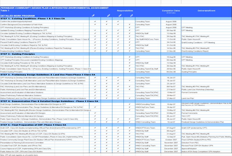
An overview of the CDP
work program is shown on Table 1. Detailed Work Plans for the specific Plans
and Studies will be reviewed and approved by City staff in consultation with
the interested Government Review Agencies. The overall program will be
completed in five steps as described in the following paragraphs. Steps 1 and 2
comprise Phase 1 of the Fernbank CDP process while Steps 3, 4 and 5 comprise
Phase 2.
The Fernbank CDP general
work schedule is expected to take approximately fifteen months to complete,
within the two-phased approach. The
first phase is anticipated to commence in August of 2006 and continue until
November of 2006, and involve the collection of background information and data
and the establishment problems, opportunities and guiding principles for the
preparation of the Fernbank CDP.
Identification of alternative solutions will be developed in concert
with the establishment problems, opportunities and the evaluation and selection
of the alternative solutions will benefit through input from the guiding
principles. This work is intended to
satisfy phases 1 and 2 of the MEA Class EA process as illustrated in Figure 4.
The second phase is
anticipated to commence in January 2007, and involve the preparation, review
and selection of alternative land use plans and alternative designs for
required Schedule C Class EA projects, as well as the preparation of design
guidelines, a demonstration plan and will culminate in Council’s adoption of
the Fernbank CDP and an implementing Official Plan Amendment in the last
quarter of 2007. Phases 3 and 4 of the
MEA Class EA process will be included within the second phase of the CDP Study
process.
A key first step in the
Environmental Assessment process is to identify the need or opportunity for a
project. The OMB decision approved
certain portions of the CDP Study Area for urban (primarily) residential land
uses to contribute to a supply of required urban residential lands. The OMB concurred with the evidence that
future planning studies (such as those described herein) address the whole of
the area north of Fernbank and indicated it could support an urban designation
for the whole area.
The CDP study area
boundaries will recognize those adjacent areas that may be affected by the
proposed undertaking. The spatial
boundaries may vary depending on the environmental features being investigated
in order to address environmental affects and operational issues; to
accommodate coordination with relevant on-going studies and projects; and to
identify infrastructure needs and future connections. For example, transportation projects result in noise
and air quality impacts outside the CDP boundary; stormwater drainage or works
within the watershed could have upstream and downstream impacts, and disruption
of wildlife corridors could have impacts outside the CDP area. Any potential off-site impacts will be constructively
addressed to identify appropriate mechanisms for moving forward.
The intent of Step 1 is
to gather all information that exists for the CDP study area to inform the CDP
process, identify information gaps and opportunities, and to serve as a
springboard to address issues affecting the community, including impacts on
community facility services, (which may, in turn, affect infrastructure phasing
and front-end financing). An inventory
of the existing natural, social and economic environment will be documented as
outlined below:
Land Use:
·
Summary of existing Official Plan Designations and Zoning.
·
Summary of existing and proposed land uses – both within and adjacent to
the CDP Study Area.
·
Review of all relevant Land Use Planning Documents, to include approved
policy/regulatory documents (i.e., Official Plans) and on-going major land use
planning initiatives.
·
Update of relevant Official Plan appeals within the context of this
study.
Subwatershed:
·
Information from completed and ongoing Subwatershed Studies will be
incorporated into the CDP.
·
Ongoing Natural Environment Existing Conditions work will address the
following, including any opportunities or constraints such elements may pose on
the future development of the area:
<
Fisheries: The location of any
fish habitat within the Carp River, Jock River, drains, roadside ditches and
creeks within the whole CDP study area.
<
Vegetation: The vegetation
communities (including woodlots, significant tree stands and hedgerows) within
the study area will be documented (in descriptive form and on figures) and
where relevant, these vegetation communities may be assessed on the basis of
the evaluation criteria contained within the ‘Urban Natural Features Environmental Evaluation Study’.
<
Wildlife: A summary of the field inventory
surveys will be presented in table format and lists. The significance on a
national, provincial and regional level will be determined.
<
Natural Area: A literature review of
existing information on natural areas within the study area will be completed.
<
Fluvial Geomorphic: A review of existing
conditions surrounding the Carp River basin and other tributaries within the
study area
Transportation:
·
Review intersection volumes and Levels of Service for the Existing Road
Network in the study area (to include Main Street, Hazeldean, Huntmar Extension,
Iber, Terry Fox, Eagleson, Fernbank, Shea, Abbott Street East, and Hope Side
Road).
·
Overview of Fernbank Community Transit Service.
·
Overview of existing pedestrian and cycling networks.
·
Review Eagleson/Terry Fox screen lines and their existing capacity.
Infrastructure (water, sanitary, storm, major utilities):
·
Review existing conditions both within the CDP study area and the
systems to which future development may connect them.
·
Provide an overview of presently planned infrastructure improvements.
·
Hydrogeological and geotechnical information;
·
As a component of the infrastructure overview and Subwatershed work,
soils information will also be gathered.
·
Review previously completed servicing reports for the study area.
Cultural Heritage:
·
Evaluate archaeological and historical significance potential based on
Provincial data and determine areas for further assessment;
·
Within areas for further assessment, conduct a review and assessment of
properties potentially possessing design, physical, historical or contextual
cultural heritage value or interest;
Parks and Recreation
·
Information regarding parks and recreation facilities in the area
o
Trans Canada Trail
o
Carp River Recreation Pathway
o
Goulbourn Recreation Complex and Skate Park
If it is determined that
information gaps exist, the impact of the gaps and how they will be addressed
will be defined in this step of the work program.
The preliminary Existing
Conditions information is to be presented at the first TAC meeting (#1) and first PAC meeting (#1), and distributed
to the interested GRA for review and comment in advance of Open House
(#1). Both the PAC meeting and Open
House will provide opportunities for the community to identify key local
community issues that will be important to the activities of the overall work
plan. These local issues will also
inform the development of the Guiding Principles to be established in the next
step of the work plan. A second TAC
meeting will be held to finalize the existing conditions reports
Deliverable:
·
Preliminary Existing Conditions Reports with Maps endorsed by the CPT.
The intent of this step
is to establish the Guiding Principles for the CDP which will provide a
framework for subsequent community designs and detailed land use patterns. The
Guiding Principles are to be consistent with the City of Ottawa Official Plan
and reflect:
·
The existing conditions of the Study area;
·
The preliminary opportunities and constraints produced by those existing
conditions; and,
·
Community and landowner interests and issues.
The Core Project Team
will conduct a facilitated round-table session, in advance of the finalization
of the Existing Conditions Reports, once sufficient existing conditions
information is assembled. The Guiding Principles are to be vetted by the TAC
and PAC.
The first Public Open
House (#1) represents a discretionary point of contact with the public and
review agencies in accordance with the Municipal Class EA. The Meeting will be held to jointly address
Step 1 and 2 components of the Study process, including the introduction of the
CDP process, explanation of the Planning Act and Municipal Class EA integration
process; present findings to date (i.e. Guiding Principles & Preliminary
Existing Conditions) and to elicit input on opportunities and issues to be
addressed by the CDP and Environmental Assessments. Public Open House No. 1 will also be utilized to further interest
local residents in participating in the process (i.e., future workshop
participants).
A key activity which will
be completed as part of Step 2 in the work program is a Facilitated Session
& Workshop for the CPT to establish the Guiding Principles for the CDP. It
is recognized that the CDP with its Demonstration Plan will support the goals
and objectives of the City of Ottawa Official Plan; however, it will be of
great benefit to establish the Guiding Principles as early as possible in the
CDP process.
Deliverables:
·
Guiding Principles endorsed by CPT.
·
Final Existing Conditions Report endorsed by CPT.
Three alternative Land
Use Plans conforming to the Guiding Principles and infrastructure alternatives
identified in the Master Plans and Studies will be produced by the consulting
team in collaboration with the CPT, TAC, PAC and the public at large. During Step 3, broad preliminary community
design guidelines that support the initial land use plans and infrastructure
alternatives will also be produced.
Three design workshops will
be held, the first with the TAC and interested GRA, the second with the PAC and
the third with the broader public. The workshops will form the first mandatory
point of contact with the public and review agencies in accordance with the
Municipal Class EA requirements. The
results of the workshop, in conjunction with technical analysis by the
consulting team, CPT, and TAC, will inform the identification of three
alternative land use plan and the selection of a recommended land use plan and
preferred alternative solution. The
impact assessment and evaluation of the alternatives will be documented and
form the basis for confirming the preferred infrastructure alternatives. The
recommended land use plan is to be endorsed by the CPT and is to form the basis
for the preparation of the Demonstration Plan.
All alternative land use
plans and infrastructure alternative solutions will be supported by
corresponding studies relating to the environment, water, wastewater,
stormwater, and transportation. The Guiding Principles developed in Step 2 will
be used to develop the evaluation criteria for the alternatives. Assessment and evaluation of the
alternatives will involve the identification of the effects of alternatives
based on a range of technical and environmental criteria and considerations.
Deliverables;
·
Three Design Workshops
·
Recommended Land Use Plan endorsed by CPT
·
Preliminary Preferred Alternative Solutions
In this step, the preferred
Land Use Plan will be used as the basis for the preparation of the detailed
Design Guidelines, alternative infrastructures designs and create a
Demonstration Plan. The purpose of the Demonstration Plan is to illustrate at a
finer level of detail how the Land Use Plan and infrastructure alternative
solutions could develop in the future in accordance with the Design Guidelines.
Assessment and evaluation
of the alternatives and Demonstration Plan will involve the identification of
the effects of alternatives based on a range of technical and environmental
criteria and considerations. The
Demonstration Plan will include such features as local roads and block patterns
and all levels of municipal parks incorporating the preferred alternative
designs. The Demonstration Plan along
with technical analysis will be distributed to the CPT, TAC, GRA and PAC for
review and input.
The alternative
infrastructure solutions selected and presented at the public workshop in Step
2 will be presented again at Open House #2 as well as the results of Step
3. This Open House and TAC Meetings
represent the second mandatory point of contact with the public and review
agencies in accordance with the Municipal Class EA requirements.
The Demonstration Plan
will be used as a starting point for future site plan and draft plan of
subdivision applications. It is not to
be viewed as the final detailed blueprint for the future development as it is
anticipated that the CDP will be implemented over a number of years. As such,
some flexibility in final subdivision and building design must be retained.
Phasing and implementation of future development will be addressed in the CDP
Addendums to the Class EAs may be required if there is a substantial change to
the project or environmental setting of a project. For example, a significant change to the location of the
infrastructure, where negative impacts are anticipated should be planned in
accordance with the Class EA addendum procedures.
Design Guidelines are
anticipated to address such matters as:
·
Community land use structure
·
Landscape Theme, Treatment and Maintenance
·
Open Space Systems including Parks and Recreation Facilities
·
Built Form and Streetscapes
The Demonstration Plan is
to illustrate:
·
Land Use and Density
·
Transportation Systems (including roadways, transit, pathways, etc.)
·
Key Open Space, Parks and Natural Systems
·
Integration with Surrounding Areas/Communities
·
Major Infrastructure Facilities, which may impact community design, such
as stormwater ponds or servicing corridors
The Demonstration Plan
will be produced by the Consulting Team in consultation with the CPT. and
analyzed to ensure the integration of detailed transportation and
infrastructure servicing requirements, including the stormwater management
system. It will also be assessed to ensure that it fulfills the intent of the
previously determined Guiding Principles. The Demonstration Plan, as with the
preferred Land Use Plan in Step 3, is to conform to the Master Plans and
Studies forming part of the MEA Class EA process.
The Demonstration Plan
will include visual maps/diagrams/illustrations and supporting documentation
addressing land use planning and technical information and the selection of a
preferred alternative concept plan and corresponding infrastructure (i.e.,
transportation, servicing, stormwater, environment, parks and open space). Environmental impacts and mitigation
measures associated with the infrastructure will be identified and well as any
additional work or monitoring requirements.
The Demonstration Plan will also address the those matters identified in
the November 9, 2005 City Council motion, including the integration and design
of the new north-south arterial road to accommodate development within the
study area, the preparation of a final phasing plan, examination of
infrastructure and public amenity requirements and the ability to advance their
construction through front-end financing.
It is the intent that the
Demonstration Plan with supporting documentation will form the basis of the
Final CDP produced in Step 5.
The Demonstration Plan
and Detailed Design Guidelines and supporting technical studies will be
reviewed by the TAC, PAC and review agencies with an interest in the project.
The impact assessment and evaluation will be documented and form the basis for
the preliminary preferred infrastructure alternative concepts then brought to
the second Open House for public comment.
Deliverables:
·
Demonstration Plan
·
Detailed Design Guidelines
The Fernbank CDP is to be
a comprehensive document which will clearly illustrate achievement of the CDP’s
Guiding Principles and conformance with the area subwatershed studies and MEA
Class EA process. The CDP is to be produced by the Consulting Team in
consultation with the CPT and include a primary land use planning document with
a supporting land use plan, demonstration plan, and design guidelines. There
will also be discipline-specific supporting documents, including: Transportation
Master Plan, Infrastructure/Servicing Master Plan, Cultural Heritage and
Environmental Management Plan(s), including the Carp River Restoration Plan (if
required). Open Space System Plan and Parks and Recreation Plan supporting
information will be included in either the main CDP document, or if warranted,
as a specific supporting document. The
supporting documents will be prepared to a level of detail normally provided
for Environmental Study Reports prepared in support of Municipal Class EA
projects. The supporting documents
shall include information on the problem or opportunity, alternative solutions,
alternative design concepts, preferred solution and design concept,
consultation with the public and review agencies, decision-making process, and
description of the proposed projects including the physical locations and
physical dimensions of the projects, and their Class EA project schedules.
The CDP (Main Volume) is
to include:
·
An overview of the planning process.
·
Summary of the Existing Conditions Report.
·
Guiding Principles.
·
CDP area-specific targets for Affordable Housing, Greenspace, and
Transit Use, in conformity with Official Plan policies. A summary table shall be included which
indicates the number and mix of unit types proposed, net and gross areas, and
commercial and retail floor space
·
Detailed Land Use Plan with Summary Table (including densities).
·
Demonstration Plan.
·
Design Guidelines.
·
Guidelines for Development Review.
·
Implementation and Phasing Plan, to include recommended policy changes,
the content to be included in the Official Plan Amendment, direction on zoning
provisions, comments on the appeal and
EA review processes, front-end financing.
Supporting Document –
Transportation Master Plan:
·
Identify transportation: needs, alternative solutions, alternative
designs, preferred alternatives, consultation and decision making process.
·
Identify required transportation infrastructure to support the CDP.
·
Address implementation phasing, and costing.
·
Implications and Integration of on-going and proposed environmental
assessments for transportation infrastructure within and surrounding the Study
Area.
·
Identify required pedestrian and cycling networks.
·
Transit strategy and goals.
·
Identify the need to advance transportation infrastructure as currently
defined in Council’s Transportation Master Plan, with consideration of
front-end financing opportunities, including coordination with any required
revisions to the relevant Master Plan.
Supporting Document –
Master Servicing Plan:
·
Identify water and wastewater: needs, alternative solutions, preferred
alternatives, consultation and decision making process.
·
Identify water and wastewater management systems to implement to the
CDP.
·
Identify servicing improvements which could be in addition to projects identified
in the City of Ottawa Master Servicing Plan.
·
Identify the need to advance servicing infrastructure as currently
defined in Council’s Water and Wastewater Management Master Plans, with
consideration of front-end financing opportunities.
·
Address implementation, phasing, and costing, including coordination
with any required revisions to the relevant Master Plans.
Supporting Document –
Environmental Management Plan(s):
·
Identify environmental management: needs, alternative solutions,
preferred alternatives, consultation and decision making process.
·
Environmental Management Plan for terrestrial and aquatic environments;
·
Identify stormwater management systems to implement the CDP
·
Identify natural environment consideration which are necessary to ensure
that the CDP complies with the intent of the Jock River Sub-watershed Study
(Reach 2) and Carp River Watershed/Subwatershed Study;
·
Carp River Restoration Plan (if required); and,
·
Open Space Master Plan, including design rationale guidelines for parks,
recreational pathway network and linkages, natural and cultural resources,
utility corridors, a phasing strategy, and explore opportunities for front-end
financing.
Supporting Document –
Draft Official Plan Amendment
A draft Official Plan
Amendment will be prepared for review by the CPT and TAC to facilitate the
implementation of the CDP.
The CDP, with supporting
documentation, is to be reviewed by the CPT, government review agencies, TAC,
PAC, following which it will be presented at the Public Open House #3. Following TAC, government agency and PAC
review and the third Public Open House, the CDP will be finalized and presented
to the Planning and Environment Committee (the statutory public meeting under
the Planning Act), followed by City
Council. Copies of the Notice of Study
Completion and Official Plan Amendment Adoption will be provided in accordance
with the Planning Act requirements for Official Plan Amendments, including
government review agencies. The Notice
shall provide for a minimum 30 day for appeal period.
Deliverables:
·
Final Community Design Plan with supporting documents
·
Transportation Master Plan
·
Master Servicing Plan
·
Environmental Management Plan
·
Official Plan Amendment
Appendix A
Consultation Plan
Consultation Plan
Effective consultation
and communications will play a key role in the success of the project. Broad
access, effective information, and adequate opportunity and time for input are
project goals. The methods to achieve
these goals are highlighted in this Consultation Plan.
Technical
Consultation
Consultation with key City
departments and Government Review Agencies will occur through regular contact
and direction from a Technical Advisory Committee (TAC) and ongoing contact
with Government Review Agencies (GRA).
Technical Advisory Committee (“TAC”)
The TAC will include staff of the
agencies/organizations involved in the project that have a technical interest
in the project. The role of the TAC
will be: to identify planning and design issues early on in the study process
to ensure they are addressed in a timely manner; to provide direction and
guidance on all technical matters influencing the project; to assist in the
evaluation of alternative solutions and selection of a preferred design; to
review and comment on all technical reports provided during the course of the
study; and to represent the varied interests of their particular agency,
organization or provincial/municipal department. The level of participation may vary depending on the role of the
TAC representative. For example, some
government review agencies may not wish to attend meetings at the initial steps
but would be involved in the details of the alternative designs, others may not
wish to participate in the evaluation and selection of alternatives but only to
provide a technical input. The level of
participation will be at the discretion of the agency/representative. Meeting agendas will be distributed in
advance to assist in determining if attendance/participation is required.
Roles and
Responsibilities
The varied
interests of stakeholders (i.e.,
Sponsoring Landowners, government agencies, approval bodies) will be
represented on the TAC. The Committee will meet with the CPT on a regular basis
to review work-to-date and provide comment/direction on study activities, as
appropriate. Draft reports will be made
available to the TAC and other GRA that request the information throughout the
study to facilitate understanding and to enable the Committee to provide meaningful
feedback. The TAC will also address the
full range of technical issues and comment on the special studies required to
complete the CDP and Environmental Assessment requirements. Details regarding
the roles and responsibilities of the TAC are outlined below.
The TAC Members
will:
·
represent the
interests of their organization/agency;
·
attend TAC
meetings;
·
participate in
the process by providing technical input and advice;
·
work towards a
consensus for actions and approvals for project milestones; and
·
disseminate
information to the organization/agency they represent.
Administration
·
The TAC will
be co-chaired by the Fernbank CDP Project Managers (Walker, Nott, Dragicevic
Associates Limited and the City of Ottawa)
·
Meetings will
be held at the discretion of the Chairs
·
The Chairs
will be responsible for ensuring adequate notification to members of upcoming
meetings, meeting agendas, and the overall conduct of meetings
·
Materials and
draft reports will be provided to all TAC members in advance of scheduled
meetings
The Meeting Notes will be prepared by
the Consulting Team and circulated for review and approval following each
meeting.
Meetings will
not generally be open to the public.
The general public will have opportunities to review and comment on the
study progress and outcomes at Public Open Houses scheduled at key points in
the study.
Government Review Agencies (GRA)
The proponent is responsible for
ensuring that review agency consultation is carried out in accordance with the
requirements of the Municipal Class EA.
Review agencies with an interest in the project shall be provided with
copies of all notices prepared for the project and requested to provide input
and comments during phases 2, 3 and 4 or the Class EA process. This consultation shall be over and above
invitations to TAC meetings, and shall include all provincial and federal
ministries and agencies with an interest in the project (not limited to
agencies listed as participants in the TAC).
GRA representatives may also be
invited to sit as regular members of the TAC.
The level of participation may vary depending on the role of the
GRA. For example, some government
review agencies may not wish to attend meetings at the initial steps but would
be involved in the details of the alternative designs, others may not wish to participate
in the evaluation and selection of alternatives but only to provide a technical
input. The level of participation will
be at the discretion of the agency/representative. TAC meeting agendas will be distributed in advance to assist in
determining if attendance/participation is required.
Public Advisory
Committee (“PAC”)
The varied interests of stakeholders
(i.e., community associations,
non-sponsoring landowners/users and special interest groups) will be
represented on the Public Advisory Committee (PAC). The PAC will meet and collaborate with the study team on a regular and
more informal basis to assist in establishing the guiding principles of the
CDP, review work-to-date, and provide comment/direction on study activities, as
appropriate. Progress reports will be
made available throughout the study to facilitate understanding and to enable
the Committee to provide meaningful feedback. Details regarding the roles and responsibilities of the PAC
are outlined below.
The PAC Working Members will:
·
represent the
interests of local residents, community associations and business associations
and interest groups in the study area;
·
attend every
PAC meeting
·
participate in
the evaluation of alternatives by offering advice, expressing opinions, and providing
local knowledge;
·
disseminate
information to the association/organization they represent; and
·
become
informed and involved in the process
Administration
·
The PAC will
be chaired by the Fernbank CDP Project Managers (Walker, Nott, Dragicevic
Associates Limited and the City of Ottawa)
·
Walker, Nott,
Dragicevic Associates Limited in coordination with the City will be responsible
for ensuring adequate notification to members of upcoming meetings, meeting
agendas, and the overall conduct of meetings.
·
The meeting
notes will be prepared by the Consulting Team and circulated for review and
approval following each meeting.
·
Materials and
draft reports will be provided to all TAC members in advance of scheduled
meetings
Meetings will not generally be open
to the public. The general public will
have opportunities to review and comment on the study progress and outcomes at
Public Open Houses scheduled at key points in the study work program.
Integrated Planning Notice
Requirements and Consultation
Under the proposed integrated
planning process, the public consultation and notice requirements of both the
Municipal Engineer’s Association Class Environmental Assessment (“Class EA”)
and the Planning Act will be adhered
to. The Sponsoring Landowners will be
responsible for coordinating with the Consulting Team Project Manager and the
City to schedule public meetings and workshops and to implement notice
requirements.
The Environmental Assessments will be “integrated”
with a Planning Act approval (Official Plan Amendment), and the requirements of
section A.2.9 of the Class EA must be met in terms of public and review agency
notification and consultation, and documentation; appeal will be to the Ontario
Municipal Board rather than the Minister of the Environment (approach # 4).
It must be clear to the public and review agencies at
the outset of the Class EA process and in public notices:
·
which approach will be followed for each of the
infrastructure Master Plan and which Class EA phases will be completed;
·
future assessments and/or Class EA work that will be
need to be completed prior to construction;
·
final notification of completion of schedule B and C
projects will be done at the same time and in the same notice as the final
notification of completion of the Master Plans and the final notice for the Planning Act Approval,
·
Opportunities for consultation in the future,
·
Opportunities for appeal.
Notices will also be provided to the Environmental
Assessment and Approvals Branch (EAAB), with a brief summary of how the Master
Plan followed the Class EA requirements. This information is required for
tracking purposes, to monitor the effectiveness of the Master Plan approach.
Each published notice shall state
that the notice and corresponding public meeting are intended to meet the
requirements of both the Municipal Class EA process and the Planning Act, and that the Municipal
Class EA process will be integrated with the Planning Act approval in
accordance with section A.2.9 of the Municipal Class EA. The notice shall provide information on the Planning Act approval to be obtained
(Official Plan Amendment) and the infrastructure to be approved under the
Planning Act through the integration process.
The Class EA notice requirements
differ from those of the Planning Act
as they require notification throughout the process for the purposes of
encouraging consultation on options and decisions. The type of consultation under the Class EA is left up to the
proponent while under the Planning Act;
one public meeting would be required for the purposes of an Official Plan
Amendment. Notices shall identify the
infrastructure projects that will be implemented under the OPA and supporting
Master Plans. Notice shall specify that concerns about the OPA and the proposed
infrastructure shall be to the OMB.
A web-site will be prepared by the
Sponsoring Landowners and will provide notices of upcoming meetings as
described in the Detailed Work Program (Table 1), and post final deliverables
such as reports, the demonstration plan and alternative land use plans, and
design guidelines.
DOCUMENT
2
STUDY AREA