Report to/Rapport au :
Planning and Environment Committee
Comité de l'urbanisme et de
l'environnement
and Council / et au Conseil
1 September 2005 / le 1 septembre
2005
Submitted by/Soumis par : Ned Lathrop, Deputy City Manager/Directeur
municipal adjoint,
Planning and Growth Management/Urbanisme et Gestion de la croissance
Contact
Person/Personne ressource : Karen Currie, Manager
Planning and Infrastructure
Approvals/Approbation des demandes d’aménagement et d’infrastructure
(613) 580-2424 x28310, karen.currie@ottawa.ca
|
SUBJECT: |
|
|
|
|
|
OBJET : |
REPORT RECOMMENDATIONS
That
the Planning and Environment Committee recommend that Council:
1.
Approve an amendment to the City Council Approved Official Plan for
the lands at 15 and 81 Colonnade Road North as shown in Document 1 and detailed
in Document 3.
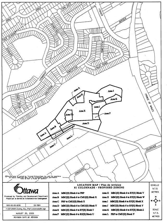
2. Approve an amendment to the former City of Nepean Zoning By-law to change the zoning for the lands at 15 and 81 Colonnade Road North as shown in Document 4 and detailed in Document 5.
RECOMMANDATIONS DU
RAPPORT
Que le Comité de l’urbanisme et de
l’environnement recommande au Conseil :
1. d’approuver
une modification au Plan officiel de la Ville d’Ottawa approuvé par le Conseil
municipal visant les terrains au 15 et 81, chemin Colonnade nord indiqués dans
le document 1 et précisés dans le document 3.
2. d’approuver
une modification au Règlement municipal de zonage de l’ancienne Ville de Nepean
en vue de changer le zonage pour les terrains au 15 et 81, chemin Colonnade
nord indiqués dans le document 4 et précisés dans le document 5.
BACKGROUND
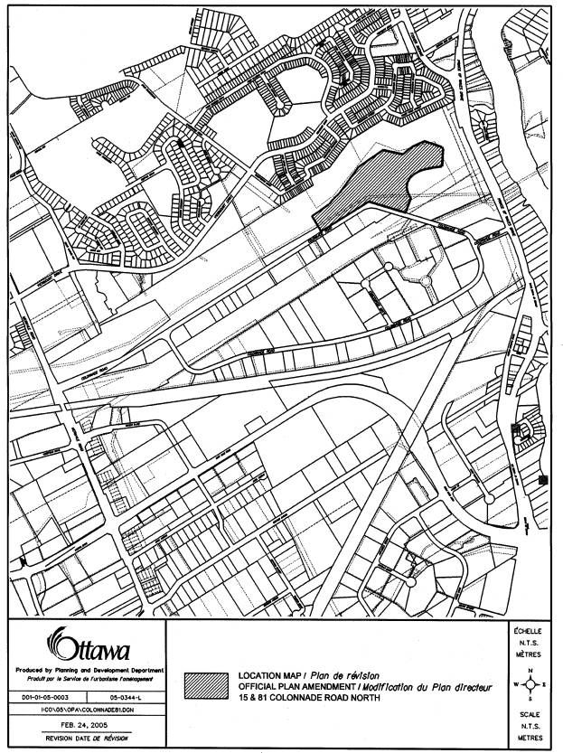
The subject property is located on the north side of Colonnade Road
North, adjacent to the Colonnade Business Park. It is a vacant site with an area of 8.7 hectares. A location map is attached as Document
1. To the immediate south of the site, across
Colonnade Road, is the Colonnade Business Park which contains a mix of office,
light industrial, and sample/showroom uses. To the west are City owned soccer
fields. To the north and east is City
open space consisting of Nepean Creek with a recreational pathway running along
the top of bank and stormwater management facilities. Further to the north,
across the Nepean Creek valley, are existing low density residential uses in
the communities of Fisher Glen and Carleton Heights.
Development Proposal
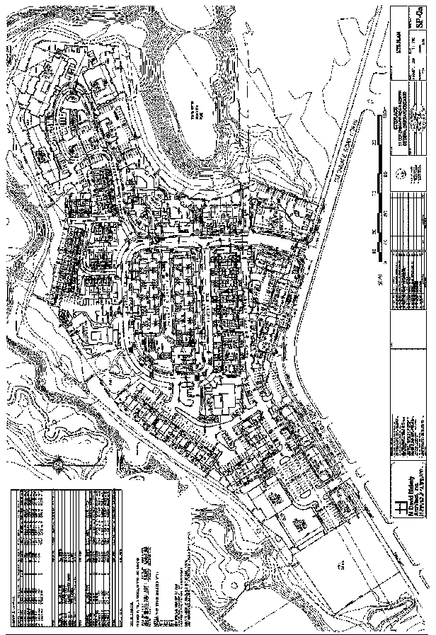
The proponent has prepared a conceptual site plan for the proposed
development in support of the applications (Document 2). The plan proposes a compact, mixed use
development of office, retail and residential uses. Proposed adjacent to Colonnade Road are a series of three storey
buildings with office or retail uses occupying the ground floor and apartment
units occupying the upper two floors. A
proposed public street that forms a "P" loop provides services and
frontage for the parcels to the interior of
the property. Several private
streets branch off of the public street.
A series of blocks are proposed to be developed that will include a
range of housing types, either in
freehold or condominium ownership.
Approximately 1100 residential units are proposed consisting of several
low, medium and high rise apartments, stacked townhouse units, back-to-back
townhouse units and conventional street townhouse units. The development will have varied building
heights and densities. Some of the
housing units will have underground parking while others will have surface
parking or parking spaces in garages.
Some of the buildings will accommodate retirement units. Private amenity space will be provided with
each cluster of residential development. Two public parks are also proposed.
An application for Subdivision Approval has also been submitted along with the applications to amend the
Official Plan and Zoning By-law. Details of the site's development will be
dealt with through the Subdivision Approval process and individual Site Plan
Control applications for each of the blocks at a later date.
Purpose of the Official Plan and Zoning Amendment Proposal
The purpose of the Official Plan Amendment is to amend Subsection
4.8.7, Land-Use Constraints Due to Aircraft Noise, of the City Council Approved
Official Plan, as it applies to the subject lands. The intent is to allow residential uses within the Ottawa Airport
Operating Influence Zone currently shown on Schedule K.
The proponent has requested that the lands be rezoned to permit
mixed use, residential and park uses which reflect the proposed plan. The application also requests approval to
remove the Holding provision on the basis that a Traffic Impact Study and a draft
road infrastructure improvements agreement has been submitted. The Zoning By-law Amendment application also
seeks to remove the Airport Operating Influence Overlay Zone applying to the
site on the basis of new noise contours that project lower levels of airport
related noise.
DISCUSSION
City Council Approved Official Plan
The City Council Approved Official Plan designates the property as General Urban Area. This designation permits all forms of housing, employment, shopping, service, industrial, park and natural areas, entertainment and institutional uses.
Former Regional Official Plan
The Regional Official Plan designation for this property is General Urban Area and the policies are similar to those found in the City Council Approved Official Plan. A range of residential uses and non-residential uses are permitted.
Former City of Nepean Official Plan
The subject property is designated Business Park in the former City of Nepean Official Plan. The purpose of this designation is to provide for both traditional industrial and current business park uses. A range of non-residential uses are permitted such as light industrial, office, institutional, business and personal service uses, and convenience stores.
Due to there being no appeals to the City Council Approved Official Plan with respect to the subject lands and based on the submission date for these applications, the new Official Plan prevails and will be used in the evaluation of the subject proposal.
Existing Zoning
The current Zoning By-law zones the lands Industrial Business Campus - MBC(H) Blk 6. This zoning allows a range of business park related uses including uses such as a bank, business office, light assembly and production, multiple occupancy industrial building, and restaurant. The zone applies a maximum building height is 11.5 m and the maximum floor area ratio is 0.4. Removal of the Holding provision is conditional upon the submission and approval of a Traffic Impact Study, an agreement between the City and the owners of the subject lands regarding cost sharing and implementation of a schedule for construction of road infrastructure improvements generated by development and submission and approval of a site plan application to the satisfaction of the City. The Zoning By-law also applies an Airport Operating Influence Overlay Zone which specifically prohibits noise sensitive land uses.
Proposed Official Plan Amendment
The site is within the Airport Operating Influence Zone in the City Council Approved Official Plan, one of two zones designated in the Plan to identify areas where land use and future development is constrained by aircraft noise. New residential uses are considered a noise-sensitive land use and are not permitted in this zone. The boundaries of these zones are based on the projected levels of noise around the airport resulting from current and future airport operations. Federal guidelines for land use have been based on two measures of projected noise, the Noise Exposure Forecast (NEF) and the Noise Exposure Projection (NEP) that can be depicted as noise contours around the airport. The boundary of the Airport Operating Influence Zone is based on the 30 NEF and NEP contour, whichever is more restrictive. A composite of the 30 NEF/NEP contour has been created and mapped against physical features on the ground, to define the boundary of the Airport Operating Influence Zone and thus make the policy more readily interpreted and applied.
Since the adoption of the Official Plan by City Council in May 2003, the NEF and NEP contours were revised by the Ottawa International Airport Authority in 2005 to reflect updated projections of future airport activity and associated noise. The subject site is outside both the revised 25 and the 30 NEF and NEP contours. The work of mapping the revised contours against physical features to amend the boundary of the Airport Operating Influence Zone and other designations on Schedule K is ongoing. A comprehensive Official Plan amendment is being prepared and will be brought to Committee and Council late this fall, following community consultation.
However, a site specific Official Plan Amendment is being recommended at this time for the subject property, prior to the OPA being brought forward, as it appears that the subject site will be outside the revised Airport Operating Influence Zone to be proposed in the amendment. The site will continue to be within the Airport Vicinity Development Zone, where the Ottawa International Airport Zoning regulations apply and affect such matters as the location and height of objects on lands near the airport.
If the current airport noise constraint did not apply to the site, an Official Plan amendment would not be required and the development applications for the site would be evaluated in accordance with the General Urban Area policies. The General Urban Area designation encourages the development of a full range and choice of housing types, densities and sizes for a variety of demographic profiles, in combination with conveniently located employment, service, leisure, entertainment and institutional uses. Official Plan policies support intensification, like the proposed development, in a manner that enhances and complements the desirable characteristics and ensures the long-term vitality of the existing surrounding community. The proposed development is a well-designed, mixed-use community offering a wide range of housing types and forms of tenure, plus employment, commercial space for uses such as shops, restaurants, day-care centres and medical facilities, and active and passive parkland space. Clustering of neighbourhood scale commercial services as part of the development with good pedestrian connections, make the development more complete and walkable. It will be an integrated development with the opportunity to work, live, shop and play in the same general area.
Evaluation of Zoning Proposal
Rezoning to Mixed Use
The proposed zoning amendment is requesting that residential uses be introduced into an area that is currently zoned for employment uses only. Recently, concerns have been raised over the conversion of employment land in the urban area generally. Areas inside the Greenbelt have not experienced any significant loss of vacant employment land to non-employment uses. The subject lands are General Urban, so although they may be adjacent to the employment area on Colonnade Road, they do not form part of the vacant employment land inventory. Generally, the area inside the Greenbelt has an excess of jobs over housing, while the opposite is true outside the Greenbelt. Hence, there is not a concern that this parcel is being developed for residential over employment. The Official Plan gives priority to intensification for residential uses inside the Greenbelt. The proposed development clearly supports this priority while not significantly compromising the employment land base. It is also important to note that the proposed rezoning will require a significant amount of employment uses to be developed on the site, in conjunction with the residential uses. The proposed zoning amendment will require a floor area of approximately 6848 m2 of employment uses. Finally, as a significant portion of the proposed housing will meet the City’s affordability targets, it will achieve an Official Plan objective of promoting the development of affordable housing through intensification.
Compatibility and Diversity
When considering a proposed change of land use, the compatibility of the proposed use must be evaluated. The concept plan for the development of the site takes into consideration the pattern of the surrounding area. The adjacent open space containing stands of mature trees and stormwater retention facilities provide a wide buffer between the residential community to the north and also housing on the east side of Prince of Wales Drive. Along the Colonnade Road frontage, the use of three storey buildings with office and showroom uses on the ground floor and apartments above provide a transition between the business park across the street and the residential uses proposed for the interior of the subject property. The use of two and three storey buildings towards Colonnade Road with high rise apartments planned farthest from Colonnade Road also provides a transition and separation space with the one and two storey buildings on the south side of Colonnade Road. The addition of a sidewalk and street trees along the north side of Colonnade Road, adjacent to the development, along with on-site parking areas being planned to be at the side or rear of buildings, will provide a pedestrian friendly, attractive streetscape.
This proposal will contribute to the diversity of the land use and activity in the area. As the surrounding community does not contain a wide range of housing types to meet the needs of all ages, incomes and life circumstances, this development will contribute to the diversity of the area by offering a choice of housing. It will inject new investment into an area that contains mainly non-residential uses which may result in additional future investment as the area reinvents itself as a mixed-used neighbourhood. As well, the provision of two public parks as part of the proposed development, meets an identified need for recreational space for future residents as well as providing existing employees and residents of the area with additional park space. Finally, the proposed development can to be supported by existing infrastructure, including sewer, water and a major collector road, meeting a major underlying principle in the Official Plan of optimizing existing infrastructure wherever possible.
Transportation
In support of this application, a Traffic Impact Study was prepared and it concluded that the proposed residential-based development is compatible with the existing business park development from the perspective of maximizing the directional capacity of the surrounding transportation network. In peak periods, traffic from the subject development will travel mainly in opposite directions from that of traffic associated with the business park. Overall, the study concluded that the increase in traffic attributed to the proposed development will be 3%. The study indicates that the surrounding roadways and intersections which would serve the development, are operating at capacity during peak periods, but the addition of the traffic from the proposed development would only slightly add to traffic volumes. Some intersection modifications are recommended such as the addition of a second westbound left-turn lane on Colonnade Road onto southbound Merivale Road. A cost-sharing agreement between the City and the owners of the subject lands as well as two other parcels of land yet to be developed on the north side of Colonnade Road, is to be completed and approved by the City prior to the Holding zone be lifted. Three OC Transpo routes currently operate on Colonnade Road in the vicinity of the subject lands. Additional routes may have to be added after project build out. Finally, possible construction of the proposed east-west light rail line along the existing CN rail corridor just south of the business park, with possible stations at the western and eastern limits of the business park, is seen as a positive feature for this development from a transportation perspective.
Pedestrian Network
With respect to integration of the development with existing pedestrian and bicycle networks, the proposed pedestrian network identified within the site plan provides good connection to the existing recreational pathway system situated to the north and east of the site. The provision of a sidewalk on Colonnade Road is proposed along the site's frontage. Sidewalks are also planned for both sides of the public street from where it connects with Colonnade Road and to the inside portion of the "P" loop that is adjacent to the terrace homes. A need has been identified for a link to the Fisher Glen community to the north to allow future residents to access the schools and other community facilities located in that community. Conceptually, this could be easily accomplished by the installation of a bridge structure across Nepean Creek immediately north of the proposed development and in the vicinity of Coolspring Crescent in Fisher Glen. This enhancement to the existing pathway network is also viewed as being beneficial to the existing residents located to the north to allow them better access to the business park and surrounding recreational pathways and parkland. Details with respect to location, timing and financing of the bridge will be confirmed through the subdivision approval process. The proponent has committed to contributing towards the cost of the bridge.
Environmental Studies
The adjacent City-owned property in which is located the Nepean Creek is designated as an Urban Natural Feature on Schedule B to the Official Plan. As the subject property is within 30m of an Urban Natural Feature, an Environmental Impact Study is required. The approach taken by the environmental consultants was to identify the most important features on the property that could be incorporated into the development in keeping with the City's design with nature policy and to ensure that no negative impact occurs on features and functions of the existing Urban Natural Feature on the adjacent property. A Preliminary Tree Preservation Plan has also been submitted which includes an assessment of the quantity and quality of tree cover and opportunities for additional plantings. The environmental consultants noted that the most mature trees in the area are either located off-site along the banks of the Nepean Creek or on-site along the perimeter of the property where the Tree Preservation Plan included the retention and preservation of these stands. The environmental consultants concluded that use of mitigative measures, environmentally sensitive construction techniques and implementation of the recommendations in the Tree Preservation Plan will minimize impacts to the retained forest blocks and vegetation outside the development envelope. Details and implementation of the recommendations from the environmental reports will be done through the subdivision and site plan approval processes.
Details of Recommended Zoning
The applicant has requested that the property be zoned in a manner which will permit the proposed development and that special provisions, reflective of the proposed concept plan, be applied to the site. The application also seeks to have the Airport Operating Influence Overlay Zone removed from the site on the basis of the new NEF and NEP noise contours that project lower levels of airport related noise being experienced on-site. Finally, the application also requests that the Holding provision be removed on the basis that a traffic impact study and cost sharing proposal have been submitted.
Staff are recommending three main zones be applied to the site, as shown in Document 4 and detailed in Document 5. Firstly, the two proposed public parks located on the western edge and north central area of the property will be zoned Parks and Recreation (Public). Secondly, the areas which will contain the mixed use buildings located along Colonnade Road and in the north west corner of the property will be zoned Commercial Mixed Use - CMU (H).Within this zone there will be two sub-zones (special provisions) in order to control building height and density and allow for a reduced parking standard for business office of 1 space per 50 m2 of gross floor area. Staff are in support of the reduced parking standard for business office in this location as it has been approved for other office developments in the area and additional on-street parking will be available on Colonnade Road.
The areas containing the residential uses will be zoned primarily Residential Seventh Density - R7(H) with a small area for a block of street townhouses being zoned Residential Fifth Density - R5(H). Within the R7 (H) zone, there are six special provision zones which will regulate land use (multiple attached or apartments), density, height, building coverage and setbacks.
As requested, staff are recommending that the Airport Operating Influence Overlay Zone be removed for reasons previously mentioned. However, it is recommended that the Holding provision remain on the property until such time as the cost-sharing agreement for required road modifications is resolved.
Conclusion
It is staff’s opinion that the subject proposal to amend the Official Plan and Zoning By-law be approved as the proposed development is suitable and appropriate for the area as it is compatible with, and will have no negative impact on surrounding uses. The rezoning proposal conforms to Official Plan policies and will contribute to the City of Ottawa's residential housing objectives.
CONSULTATION
Notice of this application was carried out in accordance with the City’s Public Notification and Consultation Policy. The Ward Councillor is aware of this application and the staff recommendation. Correspondence and phone calls from the public, both in support and against the proposal, were received including from area residents, area businesses, and the General Burns Community Association. Comments were also received from several technical agencies. An open house (March 8/05) and a community meeting (May 17/05) were held with the applicant, Ward Councillor and staff in attendance. As well, staff attended separate meetings with the Councillor and representatives of the Community Association. An additional community meeting is scheduled for September 6, 2005. A summary of the main issues identified through letters, email and the community meeting, is attached in Document 6
APPLICATION PROCESS TIMELINE STATUS
The applications were not processed within the “On-Time Review” timeframe established for the processing of Official Plan and Zoning By-law Amendment applications due to the detail in the submission of required studies and the complexity of the subject applications.
FINANCIAL IMPLICATIONS
SUPPORTING DOCUMENTATION
Document 2 Conceptual Site Plan
Document 3 Draft Official
Plan Amendment to the City Council Approved Official Plan
Document 4 Proposed Zoning
Map
Document 5 Details
of Recommended Zoning
Document 6 Consultation Details
DISPOSITION
Department of Corporate Services, Secretariat
Services to notify the owner (Ashcroft Homes , 18 Antares Drive, Ottawa, ON,
K2E 1A9), applicant (Dave Krajaefski, Trow Associates Inc., 154 Colonnade Road
South, Ottawa, ON. K2E 7J5) All Signs, 8692 Russell Road, Navan, ON K4B 1J1 and
the Manager of Assessment, Department of Corporate Services of the City
Council’s decision.
Planning and Growth Management Department to prepare the
implementing by-laws, forward to Legal Services Branch and undertake the
statutory notification.
Department of Corporate Services, Legal Services Branch to forward
the implementing by-laws to the City.
|
|

Official Plan Amendment XX /Modifications du Plan
directeur
To
the Official Plan of the City of Ottawa
Land use
Utilisation du sol