Report to/Rapport au :
Planning and Environment Committee
Comité de l'urbanisme et de
l'environnement
and Council / et au Conseil
Submitted by/Soumis par : Ned
Lathrop, Deputy City Manager/Directeur municipal adjoint,
Planning and Growth
Management/Urbanisme et Gestion de la croissance
Contact
Person/Personne ressource : Carol Christensen, Manager/Gestionnaire
Environmental Management/Gestion de
l’environnement
(613) 580-2424 x 13242,
Carol.Christensen@ottawa.ca
|
SUBJECT: |
SIGNIFICANT WETLAND additions TO THE
GOULBOURN WETLAND COMPLEX |
|
|
|
|
OBJET : |
AJOUT DE
TERRES HUMIDES IMPORTANTES À LA TOURBIÈRE GOULBOURN |
REPORT RECOMMENDATION
That the Planning and Development Committee recommend that Council receive this report for information purposes.
RECOMMANDATION DU
RAPPORT
Que le Comité de l'urbanisme et de
l'aménagement recommande au Conseil de prendre connaissance du présent rapport.
EXECUTIVE SUMMARY
Assumptions and Analysis
The City’s Environmental Management Division in cooperation with the Ministry of Natural Resources initiated a study to identify and evaluate wetlands within the vicinity of the Goulbourn Wetland Complex. In 2004, an Environmental Impact Statement, filed as part of a development application for 6851 Flewellyn Road, identified the presence of wetland habitat on the subject property that was not previously mapped. After reviewing existing natural environment information for the area, it was determined that there could be several unidentified and unevaluated wetlands in the surrounding area including this property. Further, given the close proximity of a Provincially Significant Wetland, the Goulbourn Wetland Complex, the significance of these unevaluated wetland areas needed to be determined prior to processing the development application.
Ron Huizer with Jacques Whitford Consulting was retained in August of 2004 to carry out the wetland evaluation study. In January of 2005, Jacques Whitford submitted their report entitled “Potential to Complex Unevaluated Wetland Areas in the vicinity of the North Goulbourn Wetland Complex” to the City and MNR (see Document 1). The analysis conducted by Jacques Whitford identified twenty new wetland areas that meet all the criteria for connecting individual wetland areas with a larger wetland complex, as specified in the Ontario Wetland Evaluation System for Southern Ontario (1993).
The Ontario Ministry of Natural Resources reviewed the Jacques Whitford report and concurred with the report’s evaluation and conclusion that the twenty newly identified wetland areas form part of the Goulbourn Wetland Complex and, as such, are considered Significant Wetland.
With the confirmation of additional Significant Wetland area within the Goulbourn Wetland Complex, the City is now mandated to designate these areas appropriately within the City’s Official Plan so that these natural features and associated functions within the landscape will be retained.
Financial Implications
There are no financial implications associated with this information report.
Public Consultation/Input
A landowner information session was held on Thursday, April 21, 2005, in order to allow an opportunity for affected public to ask questions to the City and MNR regarding the newly identified Significant Wetlands on their property. Further public consultation will be conducted over the next few months leading up to and including the Official Plan Amendment.
RÉSUMÉ
Hypothèses et analyse :
La Division de la gestion de
l'environnement de la Ville d'Ottawa a lancé, de concert avec le ministère des
Richesses naturelles, une étude visant à recenser et à évaluer les terres
humides situées à proximité de la Tourbière Goulbourn. En 2004, un énoncé
d'impact environnemental produit dans le cadre d'une demande d'aménagement
relative au 6851, chemin Flewellyn, signalait la présence sur la propriété en
cause de terres humides qui n'avaient pas été cartographiées auparavant. Après
examen de l'information disponible sur l'environnement naturel du secteur, il
avait été établi qu'il pouvait y avoir plusieurs terres humides non recensées
et non évaluées dans le voisinage de la propriété. De plus, en raison de la
proximité immédiate d'une terre humide d'importance provinciale, en
l'occurrence la Tourbière Goulbourn, il fallait déterminer l'importance de ces terres humides non évaluées avant
de traiter la demande d'aménagement.
Au mois d'août 2004, on a confié à Ron Huizer,
de la société Jacques Whitford Consulting, le mandat de procéder à une étude
d'évaluation des terres humides. Cette société a soumis en janvier 2005 à la
Ville et au Ministère un rapport intitulé Potential
to Complex Unevaluated Wetland Areas in the vicinity of the North Goulbourn
Wetland Complex (Potentiel de terres humides non évaluées situées dans le
voisinage de la Tourbière Goulbourn-Nord) (voir document 1). L'analyse
recensait vingt terres humides qui répondaient à tous les critères
d'intégration à un complexe plus vaste, comme le prévoit le système
d'évaluation des terres humides de l'Ontario pour la partie sud de l'Ontario
(1993).
Le ministère des Richesses naturelles a examiné
le rapport de la société Jacques Whitford Consulting et en a accepté l'évaluation ainsi
que la conclusion selon laquelle les vingt terres humides nouvellement
recensées font partie de la Tourbière Goulbourn et doivent par le fait même
être considérées comme des terres humides importantes.
Compte tenu de cette confirmation de la
présence d'autres terres humides importantes dans la Tourbière Goulbourn, la
Ville a donc le mandat de désigner ces zones comme il convient dans le Plan
officiel, de façon que ces caractéristiques naturelles et les fonctions qui y
sont associées dans le paysage soient préservées.
Répercussions financières :
Le présent rapport n'a pas de
répercussions financières.
Consultation publique / commentaires :
On a tenu, le jeudi 21 avril 2005,
une séance d'information qui avait pour but de donner aux propriétaires
concernés la possibilité de poser des questions aux représentants de la Ville
et du Ministère au sujet des nouvelles terres humides recensées sur leur
propriété. D'autres consultations publiques auront lieu au cours des prochains
mois, soit d'ici à ce que le Plan officiel soit modifié.
BACKGROUND
In 2004, an Environmental Impact Statement, filed as part of a development application for 6851 Flewellyn Road, identified the presence of wetland habitat on the subject property. The City's natural environment database had this area classified as "forest dry", not wetlands. As City staff reviewed existing natural environment information for the area with representatives from the Ministry of Natural Resources (MNR) and Rideau Valley Conservation Authority (RVCA), it was determined that there could be several unidentified and unevaluated wetlands in the surrounding area including this property. The study area included un-evaluated wetland features in the vicinity of the TransCanada Trail, Munster Road to the west, Mansfield Road to the south and Black’s Side Road to the east. Further, given the close proximity of a Provincially Significant Wetland, the Goulbourn Wetland Complex, the significance of these unevaluated wetland areas needed to be determined prior to processing the development application.
As the evaluation of the potential wetland areas involved multiple properties and landowners, the City’s Environmental Management Division in cooperation with the Ministry of Natural Resources initiated the study to identify and evaluate wetlands within the vicinity of the Goulbourn Wetland Complex. Originally, the wetland evaluation was to be conducted as part of the on-going Reach 2 of the Jock River Subwatershed Study. However, there was a very poor response from affected landowners to allow a biologist on their property to do field investigations. As a result, Ron Huizer with Jacques Whitford Consulting was retained in August of 2004 to carry out this work in a separate contract. Mr. Huizer is a qualified wetland evaluator under the Province’s Wetland Evaluation System and also conducts wetland evaluation training on behalf of the MNR.
As property access was not available, a combined review of existing data, aerial photograph interpretation, a fly-over of the area and road-side field checks was the methodology used to identify wetlands and assess their potential for complexing with the Goulbourn Wetland Complex. Wetlands can be considered for complexing when they are located close to each other and are connected through drainage systems or other natural functions such as wildlife movement.
DISCUSSION
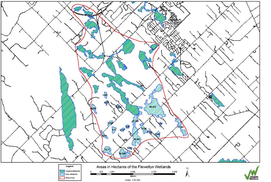
In January of 2005, Jacques Whitford submitted their report entitled “Potential to Complex Unevaluated Wetland Areas in the vicinity of the North Goulbourn Wetland Complex” to the City and MNR (see Document 1). The analysis conducted by Jacques Whitford identified twenty new wetland areas representing a total of 262 hectares of primarily swamp forest and shrub swamp wetland habitat. All twenty wetland areas identified meet all the criteria for connecting individual wetland areas with a larger wetland complex, as specified in the Ontario Wetland Evaluation System for Southern Ontario (1993). Specifically, the twenty new wetland areas meet the following criteria:
· High density of wetland area within the local landscape;
· Individual wetlands which occur within 750 m of other wetland areas;
· Wetland areas which perform a headwater function;
· All the proposed complexed wetland areas perform a similar ecological function; and
· All the wetland areas perform a habitat function in the local landscape.
The Kemptville District Office of the Ontario Ministry of Natural Resources reviewed the Jacques Whitford report. The MNR concurred with the report’s evaluation and conclusion that the twenty newly identified wetland areas form part of the Goulbourn Wetland Complex and, as such, are considered Significant Wetland.
With the confirmation of additional Significant Wetland area within the Goulbourn Wetland Complex, the City is now mandated to designate these areas appropriately within the City’s Official Plan so that these natural features and associated functions within the landscape will be retained. These functions include filtering of surface water, contribution of base water flow to the nearby watercourse, a diverse and connected plant and wildlife habitat and a carbon sink for the deposited organic material that, if drained or removed would contribute additional greenhouse gases to the atmosphere.
These twenty newly identified significant wetlands affect approximately sixty different landowners. The affected landowners were sent a letter and information package at the beginning of April 2005, notifying them that Significant Wetlands have been newly identified on their property. The information package included:
· Report by Jacques Whitford: Potential to Complex Un-evaluated Wetland Areas With the Goulbourn Wetland Complex (13 January 2005)
· Maps identifying the twenty newly identified significant wetlands to be complexed with the Goulbourn Wetland Complex – overview map plus a more detailed, larger scale version for their property
· Questions and Answers – Wetlands
· Significant Wetland Policies (Section 3.2.1 City of Ottawa Official Plan (May 2003))
· Information brochure on Conservation Land tax rebate program
The letter also invited affected landowners to an information session that was held on Thursday, April 21, 2005 at the former Goulbourn Municipal Office. The purpose of the meeting was to provide an opportunity for the landowners to ask questions of City staff, MNR staff and Ron Huizer, wetland consultant, on this matter. The meeting was well attended with approximately 90-100 people attending. Further details on the meeting are provided in the Public Consultation section of this report.
An Official Plan Amendment (OPA) process to designate these wetland areas as Significant Wetland in the City’s Official Plan will be initiated by City staff. The OPA to the Goulbourn Wetland Complex will also include wetland boundary modifications to existing wetland areas and addition of another newly identified wetland in the Rothbourne /Hazeldean Road/Highway 7 area. There will be considerable public involvement over the next few months leading up to and including the Official Plan Amendment such as:
· On-going communications and correspondence with affected and interested public;
· Meetings with individual affected landowners upon request;
· Field visits in June and July of this year by Ron Huizer to confirm presence of wetland habitat and boundary delineation, at the request by landowners;
· Revised consultant report to document any changes to wetland areas and boundaries as a result of field visits on individual properties (Summer 2005);
· Notification of Official Plan Amendment to affected landowner, adjacent landowners and broader community in keeping with planning approvals notification process (early Fall 2005);
· Public meeting as required under the Planning Act to present proposed Official Plan Amendment (late Fall 2005); and,
· Official Plan Amendment to be brought forward for approval at Planning & Environment Committee and City Council (late Fall 2005).
In addition, the newly identified Significant Wetlands will be presented and discussed at the upcoming Public Open House for the Jock River Reach 2 Subwatershed Study being held on June 9th to present the Phase 1 - Existing Conditions report.
ENVIRONMENTAL IMPLICATIONS
Wetlands are essential components of the ecosystems that contribute to the high quality of our natural environment in Ottawa. Wetlands are the most productive and biologically diverse habitats in Ontario. They play a critical role in the water cycle. By protecting wetlands, we contribute to the protection of plant and animal species, and to the protection of surface water and groundwater resources.
Wetlands provide many benefits to society and perform the following important functions:
· Water Quality Improvements
· Groundwater Recharge
· Flood Attenuation
· Fish and Wildlife Habitat
Over 80% of wetlands in Southern and Eastern Ontario have been lost over the last 20 years. The Province and in turn the City of Ottawa have strong protection policies related to significant wetlands due their environmental importance.
The newly identified Provincially Significant Wetlands (PSW) are situated in the rural area and affect 60 landowners. Currently, the new Significant Wetlands fall under three designations on Schedule A – Rural Policy Plan of the City’s Official Plan:
· General Rural;
· Rural Natural Feature; and
· Mineral Aggregate Resource.
The General Rural designation is relatively unrestrictive in regard to land use. Within Rural Natural Features, limited development is possible upon completion of an Environmental Impact Statement. For the wetland areas within the Mineral Aggregate Resource designation, staff is seeking direction from the Ministry of Natural Resources as to the appropriate Official Plan designation.
The Significant Wetland designation is restrictive in terms of development defined under the Planning Act. No development or site alteration is permitted within Significant Wetlands with the exception of the following: 1) a single detached dwelling with accessory buildings on an existing lot of record that fronts on an existing roadway and where a dwelling is permitted in the zoning by-law; 2) existing agricultural operations; 3) forestry as defined by the Forestry Act; and, 4) works subject to the Drainage Act.
CONSULTATION
A landowner information session was held on Thursday, April 21, 2005, in order to allow an opportunity for affected public to ask questions to the City and MNR regarding the newly identified Provincially Significant Wetlands on their property. The meeting was well attended with approximately 90-100 people in attendance. The majority of attendees were affected landowners with interested public and rural residents also present. Staff from the City’s Environmental Management, Development Approvals, and Corporate Communications Divisions as well as staff from MNR and Ron Huizer, wetland consultant, were on hand to answer questions. A facilitator was hired to assist with the meeting. Councillor Stavinga was also present and assisted in responding to public questions.
A brief presentation was provided by City and MNR staff on the study background, rationale, methodology, findings, land use policy and land use planning process. The question and answer period lasted approximately 2 hours ensuring that all attendees had an opportunity for the questions to be asked and responded to accordingly. The majority of the questions pertained to:
· Questioned the identification of wetlands on their property
· Why are Provincially Significant Wetlands being identified now
· What is the appeal process
· Compensation / Private property rights
· Loss of property value
· Artificial creation of wetlands through improper drainage/beaver activity
· Restricted use of property – what activities could still be conducted on their property
· Continuation of agricultural operations
· Process to identify wetlands
· Official Plan Amendment Process
Meeting notes were taken and distributed to attendees. The sign-in list included an opportunity for interested landowners to indicate whether or not they would like to have an individual meeting with City staff and if they would like a site visit to be conducted on their property. City staff has been following up on these requests and site visits are being arranged for the beginning of June for those landowners expressing an interest.
Further public consultation will be conducted over the next few months leading up to and including the Official Plan Amendment. In addition, the newly identified Significant Wetlands will be presented and discussed at the upcoming Public Open House for the Jock River Reach 2 Subwatershed Study being held on June 9th as these wetlands fall within the study area.
FINANCIAL IMPLICATIONS
SUPPORTING DOCUMENTATION
Document 1 - Jacques Whitford Report and Maps
DISPOSITION
1. Environmental Management in cooperation with the Ministry of Natural Resources will undertake the consultation activities associated with this project.
2. Environmental Management will report back to Committee and Council with the Official Plan Amendment in the fall of 2005.
JACQUES WHITFORD REPORT AND MAPS Document 1