Report to/Rapport au :
Planning and Environment Committee
Comité de l'urbanisme et de
l'environnement
8 November 2004 / le 8 novembre 2004
Submitted by/Soumis par : Ned
Lathrop, Deputy City Manager / Directeur municipal adjoint
Planning
and Growth Management / Urbanisme et Gestion de la croissance
Contact Person/Personne ressource : Grant
Lindsay, Manager / Gestionnaire
Development Approvals / Approbation des demandes
d'aménagement
(613) 580-2424 x13242, Grant.Lindsay@ottawa.ca
|
SUBJECT: |
SITE PLAN CONTROL - 495 Richmond Road
(FILE NO. d07-12-04-0194) |
|
|
|
|
OBJET : |
RÉGLEMENTATION DU PLAN D'IMPLANTATION -
495, CHEMIN RICHMOND (DOSSIER D07-12-04-0194) |
REPORT RECOMMENDATION
That Planning and Environment Committee
APPROVE the Site Plan Control application for 495 Richmond Road as shown on the
following plans:
1. “Site
Plan, 495 Richmond Road: The Manor House, Drawing No. A1” prepared by Barry J.
Hobin & Associates Architects Incorporated, dated May 2004, revised October
18, 2004.
2. “Landscape
Site Plan, 495 Richmond Road: The Manor House, Drawing No. LSP-1” prepared by
Douglas Associates Landscape Architects Ltd., dated July 2004, revised October
18, 2004.
3. “Site
Servicing and Grading Plan, 495 Richmond Road, Drawing No. 2483-S2"
prepared by David McManus Engineering Ltd., dated November 2003, revised
October 19, 2004.
subject to the Owner entering into a standard Site Plan agreement including the conditions contained in Document 6. In the event that the Owner fails to sign the required agreement and complete the conditions to be satisfied prior to the signing of the agreement within one year of the Site Plan Approval, the approval shall lapse.
RECOMMANDATION DU RAPPORT
Que le Comité de l’urbanisme et de
l’environnement APPROUVE la demande de réglementation du plan d’implantation
visant le 495, chemin Richmond, comme le montrent les plans suivants :
1. Plan
d’implantation, 495, chemin Richmond - Manor House, dessin numéro A1, préparé
par Barry J. Hobin & Associates Architects Inc. en mai 2004, révisé le 18
octobre 2004;
2. Plan
d’aménagement paysager, 495, chemin Richmond - Manor House, dessin numéro
LSP-1, préparé par Douglas Associates Landscape Architects Ltd. en juillet
2004, révisé l8 octobre 2004;
3. Plan
de viabilisation et de nivellement de l’emplacement, 495, chemin Richmond,
dessin numéro 2483-S2, préparé par David McManus Engineering Ltd. en novembre
2003, révisé le 19 octobre 2004;
à la condition que le propriétaire conclue
une entente standard sur la réglementation du plan d’implantation comprenant
toutes les conditions contenues dans le Document 6. Si le propriétaire ne
réussit pas à signer l’entente requise et à remplir les conditions de façon
satisfaisante avant la signature de l’entente dans une période d’un an de
l’approbation du plan d’implantation, l’approbation deviendra caduque.
BACKGROUND
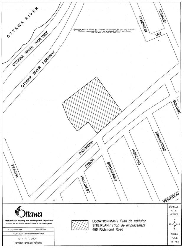
495 Richmond Road is a 1.4 ha property located
on the north side of Richmond Road and east of Broadview Avenue as shown in
Document 1. The site has 89 m of
frontage on Richmond Road and a lot depth of approximately 118 m.
A seven-storey office building, known as the
Denis Coolican building, is located in the northwest corner of the site facing
Richmond Road. The building has a gross
floor area of 7576 sq. m and a building height of approximately 35 m. Vehicular access to Richmond Road is
currently provided by one full-movement driveway along the west side of the
site. The site contains approximately
359 parking spaces including 183 underground spaces and 176 surface spaces.
In terms of the site context, the Ottawa River
Parkway and associated open space corridor is located to the north of the
site. To the northeast are two
apartment buildings with heights of 20 and 13 storeys, and lower profile
residential uses beyond. To the east
along Richmond Road is a one-storey commercial building and a 17-storey
apartment building further to the east.
Richmond Road forms the southern boundary of the site. An east-west open space corridor is located
between Richmond Road and Byron Avenue, and a residential area consisting of a
mix of low profile residential uses is located south of Byron Avenue.
Immediately to the west of the site is open
space and the Maplelawn Estate, which includes Rochester House and the
Maplelawn walled garden. Built in
1831-1834, Maplelawn Estate is designated under Part IV of the Ontario Heritage
Act for its architectural and historical significance. Rochester House is also designated as
"Classified" by the Federal Heritage Buildings Review Office, and the
house and garden are designated as a National Historic Site. Rochester House is one of the best examples
of Georgian domestic architecture in Canada, and the walled garden is
considered to be the finest example and best preserved landscape of its type in
Central Canada.
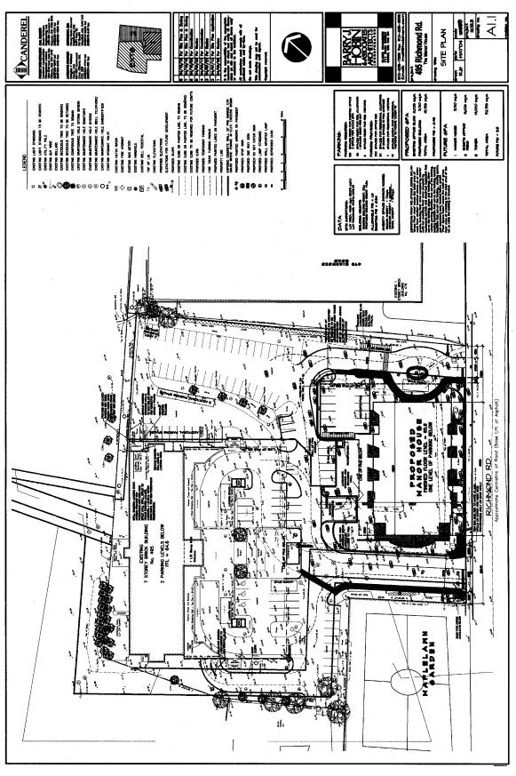
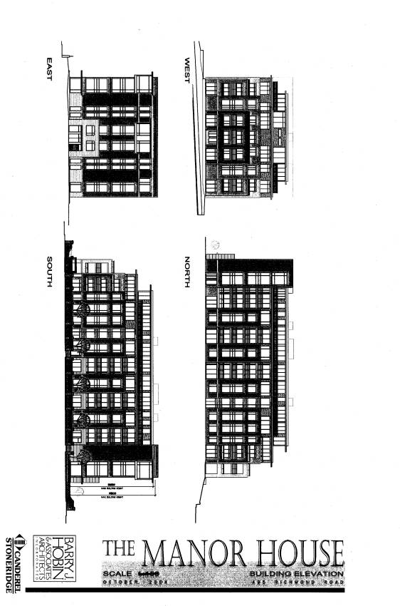
Proposed Development
The applicant is proposing to develop a
six-storey apartment building adjacent to Richmond Road. The proposed Site Plan, Landscape Plan, Site
Servicing and Grading Plan, and Building Elevations are shown in Documents 2 to
5.
The apartment building, named the Manor House,
will contain 48 dwelling units and will have a gross floor area of
approximately 5710 sq. m. A maximum
building height of 19.3 m is proposed.
Vehicular access to Richmond Road will be provided by the existing
driveway on the west side of the site and by a new driveway to be located on
the east side of the site. A passenger
drop-off area is proposed between the building and the new driveway, and the
main building entrance is located on the east side of the building facing the drop-off
area. Parking will include 57 underground
parking spaces with access provided from a ramp on the north side of the
building. 19 surface parking spaces are
also proposed on the north side of building.
The applicant is also proposing to make several
modifications to the parking area and drive aisles near the Denis Coolican
building. As part of this work, the
applicant plans to expand the existing outdoor amenity area located south of
the main building entrance. Currently,
vehicles enter the parking garage on the east side of the garage and exit on
the west side. The applicant is
proposing to provide both the entrance and exit to the parking garage on the
west side of the garage, and to increase the width of the existing drive aisle
to accommodate two-way traffic. In
addition, three loading spaces will be added in the area south of the main
entrance to the Denis Coolican building.
Concurrent Applications
The applicant has submitted a Zoning By-law
amendment application to permit the development of a 24-storey apartment
building in the northeast corner of the site.
.
DISCUSSION
Council Approved Official Plan
The Council Approved Official Plan designates
the site as General Urban Area. In
addition, the property is subject to the Mainstreet designation in the Official
Plan that applies along Richmond Road.
As the Manor House building is proposed adjacent to Richmond Road, the
proposed development was reviewed on the basis of the Mainstreet policies.
Mainstreet Policies
The Mainstreet designation identifies areas that
are intended to provide an uninterrupted network of active, mixed-use,
pedestrian-oriented uses. Permitted
uses include a wide variety of retail stores, service establishments, offices,
community-oriented facilities and residential apartments. Change and renewal within all Mainstreets
will be carried out in accordance with the principle of fostering an
environment that is architecturally pleasing, lively in its mix of uses,
oriented to the street, friendly to pedestrians and that presents a strong continuous
building edge along the sidewalk.
The Official Plan encourages intensification
within Mainstreets, particularly where it will replace surface parking areas
that interrupt the continuity of the building façades along the street. The proposed development will replace a
large portion of the existing surface parking area adjacent to Richmond
Road. The Manor House building will
have a 5 m front yard setback and will establish a strong building edge along
the Richmond Road sidewalk. In
addition, an architectural wall is proposed along the Richmond Road
sidewalk. The architectural wall will
consist of a combination of stone piers, banded concrete walls, and metal
fencing and gates. The Manor House
building and the associated architectural wall are well articulated and will
enhance the streetscape and pedestrian environment along the north side of
Richmond Road.
The addition of a residential building to the
existing office use on the site contributes to the mix of uses along Richmond
Road. Initially, the applicant had
proposed ground level retail uses for the Manor House building, which would be
more in keeping with the intent of the Mainstreet policies to provide active,
mixed-use, pedestrian-oriented uses.
However, the applicant had concerns regarding the feasibility of retail
uses at this location because the site is located at the western edge of the
Westboro commercial area with development located only on the north side of
Richmond Road. The current zoning
permits a high-rise apartment, which allows the proposed use including ground
floor residential units. It is
recognized that the current zoning does not require ground floor commercial
uses. To address the Mainstreet
policies, staff have requested that the building be designed to potentially
accommodate the future conversion of the ground floor residential units to
commercial uses. In response, the
applicant has designed the east side of the building to potentially accommodate
a future commercial use.
The Official Plan encourages elements such as
public entrances, display windows, canopies and signage to be oriented to the
street. The applicant is proposing that
the main building entrance be located on the east side of the building facing a
vehicular drop-off zone, rather than on the south side of the building facing
Richmond Road. The proposed building
entrance will be visible from Richmond Road and easily accessible by a direct
sidewalk connection to Richmond Road.
Heritage Policies
The site is
located adjacent to the Maplelawn Estate, which is a designated heritage
property under the Ontario Heritage Act and a recognized Federal Heritage
Resource. The Council Approved Official
Plan contains policies for reviewing Site Plan Control applications adjacent to
designated heritage resources to ensure that the proposed development is
compatible with the heritage resource.
To respond to these policies, the applicant has submitted a Heritage
Impact Assessment for the Manor House.
This assessment has been reviewed and accepted by staff..
Pedestrian Access to the Dominion Transitway
Station and the Ottawa River Parkway
The Dominion Transitway Station is located
approximately 300 m northeast of the subject property. Section 4.3 of the Council Approved Official
Plan provides for proponents of any development or redevelopment within 600
metres of a transit station to develop projects so as to ensure that convenient
and direct access between the proposed development and the transit station is
provided or maintained.
To address the transportation policies in
Section 4.3 of the Plan, Condition 13 in Document 6 requires that any future
development of the subject property other than as shown on the approved plans
incorporate a well-defined, safe and accessible pedestrian circulation system
that will allow for the provision of a pedestrian connection from the site to
the Dominion Transitway Station. The
City will pursue with the National Capital Commission having the existing
informal path that now exists between the site and the station formalized.
Staff believe that the location and design of
the pedestrian circulation system should be determined through the Site Plan
Control application for the 24-storey apartment building proposed at the
northeast corner of the site. This will
allow for the design and construction of the on-site circulation system to be
integrated with the future site development for the 24-storey apartment
building.
Former Regional Official Plan
The subject property is designated as General
Urban Area in the former Regional Official Plan. The General Urban Area is intended to be used primarily for
residential purposes and the shopping, services and community facilities
required to meet day-to-day needs. An
apartment building is a permitted use within this designation.
Former City of Ottawa Official Plan
The former City of Ottawa Official Plan
designates the site as Residential Area.
A Neighbourhood Linear Commercial Area designation applies to lands
along Richmond Road to the east of the site.
The Neighbourhood Linear Commercial Area designation is intended to
accommodate a wide variety of retail, office, service and community uses, and
provide for street-oriented development.
The proposed Manor House is oriented to the street and will help to
define the western edge of the Richmond Road Neighbourhood Linear Commercial
Area.
Zoning
The site is zoned "CG1[421] F(1.0)
SCH.60", which permits a maximum floor space index of 1.0. The Manor House building is classified as a
high-rise apartment building in the Zoning By-law, and the current zoning
permits this use. The Manor House
building and the Denis Coolican building, including the atrium renovation, will
have a total gross floor area of 13 736 sq. m.
The site has an area of 14 081 sq. m, and the existing and proposed
development will have a floor space index of 0.98. Therefore, the total gross floor area complies with the maximum
floor space index allowed under the present zoning.
The proposed development also complies with the
general provisions and the zone provisions in the Zoning By-law including the
parking requirements, loading requirements, setbacks, building height and
landscaped area requirements.
CONSULTATION
Notice of this application was carried out in accordance with the City’s Public Notification and Consultation Policy. Information signs were posted on-site indicating the nature of the application. The Ward Councillor is aware of this application and the staff recommendation.
Detailed responses to the notification/circulation
are provided in Document 7.
FINANCIAL
IMPLICATIONS
APPLICATION PROCESS TIMELINE STATUS
This application was not processed within the
fourteen week timeframe established for the processing of site plan control applications
where delegated authority has been withdrawn.
Additional time was needed to obtain comments from the National Capital
Commission, to address the comments received on the application, and for the
applicant to revise the Site Plan, Landscape Plan, and Site Servicing and
Grading Plan.
SUPPORTING DOCUMENTATION
Document 2 – Site Plan
Document 3 – Landscape Site Plan
Document 4 – Site Servicing and
Grading Plan
Document 5 – Building Elevations
Document 6 – Conditions of Site
Plan Control Approval
Document 7 – Consultation Details
DISPOSITION
Department of Corporate Services, Legal Services
Branch to prepare the Site Plan Control agreement.
Department of Planning and Growth Management to
notify the owner (City of Ottawa, Attention: Les Nalezinski, Program Manager,
Real Estate Services, Corporate Services Department, Mail Code 01-86), the
applicant (Geoff Boole, Canderel Construction Management Ltd., 1145 Hunt Club
Road, Suite 220, Ottawa, Ontario K1V
0Y3), the architect (Rosaline Hill and Sandy Davis, Barry J. Hobin &
Associates Architects Incorporated, 711 Bank Street, Ottawa, Ontario K1S 3V1), All Signs (8692 Russell Road,
Navan, ON K4B 1J1) and all interested
parties of Planning and Environment Committee’s decision.
LOCATION MAP Document
1
SITE PLAN Document
2
LANDSCAPE SITE PLAN Document
3

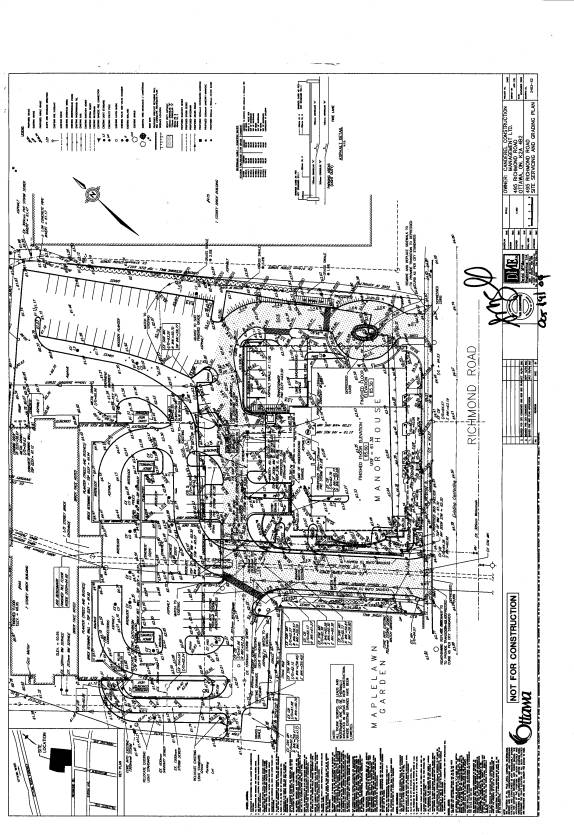
SITE SERVICING AND GRADING PLAN Document 4
BUILDING ELEVATIONS Document 5
CONDITIONS OF SITE PLAN CONTROL APPROVAL Document 6
SCHEDULE “D”
SITE SPECIFIC CONDITIONS
STANDARD CONDITIONS
The Owner(s) shall obtain such permits as may be required from Municipal or Provincial authorities and shall file copies thereof with the Director, Planning and Infrastructure Approvals Branch.
The Owner(s) agrees to extend internal walkways to connect to existing or proposed public sidewalks, at the sole expense of the Owner, to the satisfaction of the Director, Planning and Infrastructure Approvals Branch.
That prior to the issuance of a building permit, the Owner(s) agrees to prepare and implement a Waste Reduction Workplan Summary for the construction project as required by Ontario Regulation 102/94 of the Environmental Protection Act, and provide a copy to the Director, Planning and Infrastructure Approvals.
The Owner(s) agrees that the parking areas (and entrances) shall have barrier curbs and shall be constructed as approved by the Director, Planning and Infrastructure Approvals.
The Owner(s) shall provide adequate water supply for fire fighting for every building. Water supplies may be public water works system, automatic fire pumps, and pressure tanks for gravity tanks.
The Owner(s) shall be responsible to design and construct sidewalk(s) within public right-of-ways or on other city owned lands (to provide a pedestrian connection from or to the site) as may be determined by the Director of Planning and Infrastructure Approvals. Such sidewalk(s) shall be constructed to City Standards.
The Owner(s) shall reinstate at its expense, to the satisfaction of the Director of Planning and Infrastructure Approvals, any property of the City, including, but not limited to, sidewalks and curbs, boulevards, that are damaged as a result of the subject development.
The Owner(s) shall be required to install construction fencing at its expense, in such a location as may be determined by the Director of Planning and Infrastructure Approvals.
No building will be occupied on the lands, nor will the Owner(s) convey title to any building until all requirements with respect to completion of the Works as identified in this Agreement have been carried out and received Approval by the Director, Infrastructure Services, including the installation of municipal numbering provided in a permanent location visible during both day and night and the installation of any street name sign on relevant streets. Provided that notwithstanding the non-completion of the foregoing Works, conveyance and/or occupancy of a lot or structure may otherwise be permitted, if in the sole opinion of the Director, Planning and Infrastructure Approvals, the aforesaid Works are proceeding satisfactorily toward completion. The Owner shall obtain the consent of the Director, Planning and Infrastructure Approvals for such conveyance and/or occupancy in writing.
SPECIAL CONDITIONS
The Owner(s) shall convey, at no cost to the City, within six months of signing this agreement, a road widening across the complete Richmond Road frontage measuring 7.5 meters from the existing centreline of pavement. The exact widening must be determined by legal survey. The owner shall provide a Reference Plan for registration, indicating the widening. Such reference plan must be tied to the Horizontal Control Network in accordance with the municipal requirements and guidelines for referencing legal surveys and will be submitted to the City of Ottawa Surveyor for review prior to its deposit in the Registry Office.
No permanent features will be permitted above and below-grade within the widened right-of-way, including commercial signage.
The owner has undertaken a Transportation Impact Study to estimate the anticipated traffic volumes associated with the development, investigate the expected impact on the road system and determine the road modifications and other measures required to accommodate the development. This included a review of pedestrian, cycling and transit needs. The owner agrees to implement the recommendations of this report to the satisfaction of the Director, Planning and Infrastructure Approvals, and the Deputy City Manager, Public Works and Services, and all costs must be borne by the Owner.
The Owner agrees that any future development of the subject property, other than as shown on the approved plans, shall incorporate a well-defined, safe and accessible on-site pedestrian circulation system to the satisfaction of the Director of Planning and Infrastructure Approvals. The on-site pedestrian circulation system shall provide for well defined, safe and accessible pedestrian connections between the different buildings and uses located on the site, and shall be designed and located to provide direct and convenient links to the pedestrian circulation system in the area that is provided over public lands and in particular, will be designed and located to allow for the provision of a safe, direct and convenient pedestrian connection from the site to the Dominion Transitway Station through the Ottawa River Parkway Lands. In this regard, the Owner further acknowledges that the City will utilize its best efforts to work with the National Capital Commission to have the informal connection that now exists between the site and the Dominion Transitway Station formalized as a public pathway link. Also, the Owner acknowledges that the City may as a condition of approval of any revised site plan for the subject property to accommodate additional development, require the establishment of a public easement through the subject site that will facilitate public use of the on-site pedestrian circulation system that is to be established to provide for public access from Richmond Road to the existing informal or any formalized path connection from the site to the Dominion Transitway Station. Further, the owner acknowledges that modifications may be required to the location of features shown on the approved plans including, but not limited to drive aisles, parking spaces, and landscaping to accommodate the required on-site pedestrian circulation system and the owner agrees to incorporate any such required modifications within any revised site plan for additional development of the site.
The Owner(s) must prepare and implement a noise attenuation study in compliance with MOE Publication LU-131 to the satisfaction of the Director of Planning and Infrastructure Approvals Branch. The Owner(s) shall implement the noise control recommended in the approved noise study.
The proposed development is located within a sanitary collector area which has been assessed by the City to be at capacity. The Owner(s) shall liaise with the City to identify extraneous wet weather flow sources. Where flow removal cannot be achieved on site, removal of extraneous flows will be conducted through a flow removal program. The Owner(s) shall contribute $4,772/l/s x [increase in avg. sanitary flow x 1.5 peaking factor + infiltration (0.28 l/s/ha)] for additional sanitary flow generated by this site.
16.
Bus Shelter
Prior to the
registration of the Site Plan Agreement, the Owner agrees to register a public
access easement on title to accommodate a bus shelter adjacent to Richmond
Road, at no cost to the City, and to the satisfaction of the Director, Planning
and Infrastructure Approvals, and the Deputy City Manager, Public Works and
Services. The Owner further agrees to
pay all costs associated with the relocation of the existing bus shelter and
concrete pad.
17.
Landscaping Adjacent to the Maplelawn Garden
Wall
The Owner agrees to
install landscaping adjacent to the Maplelawn Garden wall. Prior to installing the site landscaping,
the Owner agrees to consult with the National Capital Commission and the
Director, Planning and Infrastructure Approvals, to select the appropriate type
and quantity of plant material to be installed in the landscaped area adjacent
to the Maplelawn Garden wall. The Owner
acknowledges that the plant material may include low-to-medium height trees. Tree species chosen should be of a type that
minimizes any impact on the heritage stone wall by the tree’s roots. The Owner further agrees that the securities
for the siteworks in Schedule ‘B’ shall include the costs of tree planting
in the landscaped area adjacent to the garden wall. The proposed drainage swale adjacent to the existing stone wall
must be maintained.
Fire Department
18.
Municipal
Number Signs
The Owner undertakes and agrees to provide and
erect or affix, at their expense, such municipal number signs, illuminated or
otherwise, in such locations and of such a size, design and colour as submitted
to and approved by the Fire Chief of the City of Ottawa prior to occupancy of
any buildings, or part thereof, in the subject development, and that any such
numbering shall be visible from the street during both day and night.
19.
Fire
Hydrants
All fire hydrants must be fully operational
prior to any structural framing and be maintained accessible and operational at
all times.
20.
Emergency
Vehicle Access
All streets or roadways shall be accessible for emergency vehicles at
all time during construction. (i.e.
clear of any and all obstructions).
21.
Fire
Access Routes
On-site roadways are to be constructed to meet the design requirements
of Section 3.2.5.6 of the Ontario Building Code, as amended from time to time
for fire access routes, where applicable.
The Owner agrees to submit five (5) copies of
the final site plan to the Fire Department for official designation of the fire
access route, where applicable, per City By-law, as amended from time to time.
23. Identification,
Maintenance, Snow Removal and Signing of Fire Routes
The Owner shall meet all the requirements of
the City’s Fire Department with respect to identification, maintenance, snow removal
and signing of fire routes.
CONSULTATION DETAILS Document
7
NOTIFICATION AND CONSULTATION PROCESS
Notification and public
consultation was undertaken in accordance with the Public Notification and
Public Consultation Policy approved by City Council for Site Plan Control
applications. One community
information and comment session was held on September 14, 2004.
COUNCILLOR’S COMMENTS
Comment: I am pleased that Canderel has amended and
updated both their original plan and traffic study in response to residents'
concerns. The study, in addition to development pressures in the area, does
indicate the immediate need for a Greater Westboro / Highland Park / McKellar
Park Traffic Management Plan. I am
hopeful that the department will respond in the affirmative to the formal
request I have made in this regard. The fact that there are two other
applications that have been submitted to the City in the immediate area also
highlights the need for a secondary planning study for the Richmond Road
corridor as pressure for development in the area continues to increase. I have
also made this request formally to staff.
The need for a pedestrian pathway linking the site to the Transitway was
also identified by residents as a priority. I fully support this item and would
like to see this included as a specific site plan condition.
Response: The timing for the preparation of an Area Traffic Management Plan and a Community Design Plan will depend on obtaining budget approval from City Council. The issue of providing a pedestrian pathway linking the site to the Dominion Transitway Station is addressed in Condition 13 of Document 6.
COMMUNITY ORGANIZATION COMMENTS
Highland Park Ratepayers Association
1. Comment: The submitted
Site Plan contravenes the zoning of the property and therefore is
unacceptable. There is no reason not to
abide by the property’s required floor space index of 1.0. The Zoning provides
for FSI of 1.0.
Response:
Floor space index is defined in the Zoning By-law as the ratio of the gross
floor area of the building to the total area of the lot on which the buildings
are located. The applicant indicated on
the initial Site Plan submission that the floor space index was 1.17. This was based on the total building area of
the Denis Coolican building and the Manor House building rather than the gross
floor area. The definition of gross
floor area excludes the floor area occupied by
mechanical, service and electrical equipment, steps and landings, motor vehicle
parking facilities, loading facilities, laundry facilities that serve the
building, play areas accessory to a principal use on the lot, amenity space and
accessory uses located below grade. The
total gross floor area of the Denis Coolican building, including the
renovation, and the Manor House building is 13 736 sq. m. As the site has an area of 14 081 sq. m, the
floor space index will be 0.98 after the office renovation and the addition of
the Manor House building. Therefore,
the proposed development complies with the maximum 1.0 floor space index under
the existing zoning.
2. Comment: Approval
of the project and accordingly the submitted site plan should only occur
following submission by the City of a Community Design Plan for the Richmond
Road area between Churchill Road and Woodroffe Road for short-term (in process)
and long-term plans. In absence thereof, the City of Ottawa Official Plan as
adopted by City Council in May 2003, has to be the applicable regulation to be
followed.
Response: Planning applications are evaluated on the
basis of the policies in effect at the time of the submission of the
application. The application was
submitted in July 2004 and was evaluated based on the Council approved Official
Plan, the former Regional Official Plan and the former City of Ottawa Official
Plan. A Community Design Plan has not
been prepared for the Richmond Road area.
The Council approved Official Plan contains policies for evaluating
applications along Mainstreets where a Community Design Plan has not been
approved, and the application was reviewed in accordance with these policies.
3. Comment:
Any acceptance of any portion of the present site plan
will not and should not imply acceptance of any other portion or the project in
total as submitted. Only the complete project should be dealt with, i.e. the
complete application.
Response: The proposed Manor House
building is permitted under the current zoning, while the proposed 24-storey
apartment building requires a Zoning By-law amendment. The City cannot delay the granting of site
plan approval for the Manor House because it is already permitted under the
current zoning. The subject Site Plan
Control application does not grant approval of the proposed 24-storey apartment
building. If the concurrent Zoning
By-law amendment application is approved, a separate Site Plan Control
application would be required for the development of the tower.
4. Comment: Acceptance of any portion of
the proposed project as compliant to the present zoning regulations, has to be
binding, in other words, any change in design size or scope to the proposal
submitted would require renewed approval. To allow any changes to the project
varying from the original proposal as accepted or outside the prevailing regulations
without a renewed enquiry and public input would make a mockery of the system
and the process designed by it.
Response: The City's Site Plan
Control By-law sets out the criteria when site plan approval is required, and
the City's Public Notification and Consultation Policy determines if public
consultation is required depending on the characteristics of the proposed
development. Any future Site Plan
Control application would be processed in accordance with the Site Plan Control
By-law and the Public Notification and Consultation Policy.
5. Comment: In order to maintain the
character of the neighbourhood, one- two- or three-storey townhouses would
better reflect and respect the long-established ‘single family homes only’
nature of the community immediately opposite the property (on Byron Avenue).
Response: The land use has already
been established by the existing CG1[421] Zone, which permits high-rise
apartments. In addition, the Council
approved Official Plan indicates that residential apartments are the only form
of residential development permitted within the Mainstreet designation. The proposed development complies with the
Zoning By-law and with the intent of the Mainstreet policies.
6. Comment: The proposed building should
be set back further from the street (i.e. the front yard should be increased)
in order to achieve the following:
a. To reflect and respect the
long-established front yard streetscape that exists along Richmond Road,
starting from Berkley Avenue in the east.
b. To reflect and respect the
long-established front yard streetscape that exists directly opposite, along
Byron Avenue.
c. To provide sufficient room for the
Shademaster Honey Locust trees in the front yard of the proposed building to
develop the healthy root systems they need in order to reach their full
potential in height and canopy, thereby providing maximum screening for the
community to the south and increasing the attractiveness of the development for
potential residents of the units fronting Richmond Road.
The southern boundary of the
existing paved parking lot should provide a more appropriate setback.
Response: The Zoning By-law
regulates the minimum front yard setback requirements. The current zoning of the site does not
require a minimum front yard setback for a high-rise apartment building in a CG
Zone where the zone abuts any zone other than an R1, R2, R3, R4 or R5
Zone. The front yard of the subject
property abuts an L2 Zone for the east-west open space corridor located between
Richmond Road and Byron Avenue.
Therefore, no front yard is required for the Manor House building. The applicant is proposing a 5 m front yard
setback, which complies with the Zoning By-law and is appropriate for a
high-rise apartment building located within a Mainstreet land use
designation. The proposed front yard
setback will provide sufficient space to accommodate the Shademaster
Honeylocust trees.
7. Comment: Access and egress points
should be one-way, restricting entrance to one driveway only and exit to
another. This would mitigate the
traffic conflict that currently exists (and that will be exacerbated by the
proposed increased development) at the dangerous, jogged “intersection” of 495
Richmond Road and Broadview Avenue. Safety
would best be served by designating the driveway to be located east of the
proposed building for egress, and the one to the west for access or to
completely eliminate access to Broadview and Byron at this location.
The community association later
submitted the following: "… we also strongly suggest imposition of having
egress located only at the eastern exit of the proposed Manor House, allowing
south-bound traffic to properly integrate into the proper lanes for
turn-off. Alternatively, access to Broadview
would have to be eliminated at Richmond."
Response: The applicant is
proposing to retain the existing Richmond Road driveway as a full-movement
access, and to add another full-movement driveway approximately 60 m to the
east. The City's Private Approach By-law permits two two-way private approaches
for the subject property based on the site's 89 m of frontage on Richmond
Road. Transportation staff have
reviewed the proposed access configuration and the applicant's Traffic Impact
Study, and have no objection to the provision of two full-movement driveways as
proposed by the applicant.
As previously noted, the Ward
Councillor is seeking budget approval for an Area Traffic Management Plan. Any potential modifications to the road
network should be analyzed as part of this study.
8. Comment: The existing egress from the
Rochester House (The Keg) was cause for great
traffic dangers already when the restaurant opened. This was alleviated
when our members, together with the City and the NCC created the present egress
through the Coolican parking lot. This
was necessary because the sight line of the exit is obstructed through the
existing wall and has caused in the past some serious accidents. Egress through
the 495 Richmond Road driveway has eliminated that danger spot. We suggest that
the City as present owner has a moral obligation to maintain the granting of
such rights into the future title. This
is even more so important, as Richmond Road has now been up-graded to arterial
road and traffic will be flowing still faster (and always exceeding the speed
limits) once the present construction in Westboro is terminated. Vehicles from the neighbouring restaurant
parking lot (at 529 Richmond Road) must continue to be permitted to exit via
495 Richmond Road. This is essential
for the safety of both the local community and the restaurant’s patrons.
Response: Currently, the National
Capital Commission does not have an access easement through the site to allow
egress to Richmond Road. The agreement
of purchase and sale between the City and the applicant does not contain any
conditions regarding the provision of an access easement in favour of the
National Capital Commission's lands.
Staff believe that it is beyond the scope of the subject Site Plan
Control application to require the applicant to provide an access
easement. Under the circumstances,
staff believe it would be appropriate for the National Capital Commission to
make arrangements directly with the applicant to resolve the access from the
Maplelawn Estate to Richmond Road.
9. Comment: The eastward line of vision
for vehicles exiting the driveway located west of the proposed building must
not be obstructed by building projections.
While the introduction of a stone wall along the front of the property
sounds (we have not seen an illustration) as if it could be appropriately
sympathetic to the Maplelawn Estate immediately to the west, it needs to be
constructed so as not to obstruct the eastward line of vision for vehicles
exiting the driveway located west of the proposed building.
Response: The Manor House building
will be setback 5 m from the front lot line along Richmond Road, and will not
affect sight lines for vehicles exiting the sight. The fence is proposed to be setback 0.35 m from the front lot
line in the area south of the Manor House building. The fence setback will increase to 6 m in the areas adjacent to
the two driveways. Sight triangles have
been provided for at the intersection of the driveways with Richmond Road. The landscape planting proposed within the
sight triangles has been selected to not exceed a height of 75 cm to ensure
that the sight lines will not be obstructed.
10. Comment: As the next-door neighbour of a
heritage house that is considered by architectural experts to be one of
Canada’s best examples of 19th century British Georgian design, the design of
the exterior of the proposed building should more explicitly complement a house
of that period. As implied in the name
of the proposed building – The Manor House – the developer clearly wishes – and
rightly so – to establish a connection with historic Maplelawn. An exterior that better reflects this house,
which carries the highest level of federal heritage designation, will
accomplish this and will make the project more compatible with the neighbouring
community.
Response: The applicant submitted a
Heritage Impact Assessment demonstrating that the design of the Manor House
building is compatible with the Maplelawn Estate. The proposed form of development and exterior materials are also
considered to be compatible with the residential area to the south. It is noted that the visual
impact of the building will be mitigated by the distance separation between the
building and the residential area, and by the buffering effect of the east-west
open space corridor located between Richmond Road and Byron Avenue.
11. Comment: Public access to the parklands
north of the property must be maintained. This should include right-of-way
access for public, non-resident, pedestrians and cyclists to the Dominion
Transitway Station.
Response: Currently, there is no public access
easement located on the subject property that would allow legal access through
the site to the Dominion Transitway Station after the applicant purchases the
property from the City at the end of 2004.
The issue of public access to the Dominion Transitway Station will be
addressed as part of the future Site Plan Control application for the proposed
24-storey apartment building. Condition
13 in Document 6 has been added to address the issue.
McKellar Park Community Association
1. Comment: Reduce the usable floor space
area (FSA) and thus reduce the floor space index (FSI) as the submitted site
plan document shows an FSI of 1.17 which contravenes the zoning of the property
and therefore is unacceptable. MPCA requests compliance with the zoning of the
property for a FSI of 1.0.
Response: See the response under Comment 1 from
the Highland Park Ratepayers Association above.
2. Comment: Provide site access and public
right-of-way access for a future pathway leading to the Dominion transitway
station and to the National Capital Commission (NCC) parklands north of the
subject site.
Response: See the response under Comment 11
above from the Highland Park Ratepayers Association.
3. Comment: Make the design and colors of
the exterior of the proposed building complement the historic NCC Maplelawn
Gardens making the project compatible with the nature of this community and
compatible with the Mainstreet designation of Richmond Road.
Response: See the response under Comment 10
above from the Highland Park Ratepayers Association.
4. Comment: Negotiate an equitable
arrangement for continued access from the Rochester building portion of the
Maplelawn NCC site to the subject site.
Response: See the response under Comment 8 above from the Highland Park Ratepayers Association.
ADVISORY COMMITTEE COMMENTS
Comment: The
Local Architectural Conservation Advisory Committee's (LACAC) Development
Review Sub-Committee reviewed the application and submitted the following
comments:
LACAC wishes to express concern in two areas of
the proposed site plan for 495 Richmond Rd. The first is the possible impact of
water runoff on the adjacent heritage garden ("Maplelawn") to the
west. Because the wall of this garden
abuts the property line, it is imperative that no runoff be permitted in this
direction. The second is the type of
plantings that will be permitted along the wall of the garden. Because they abut the heritage garden, the
plantings should be of types that relate to this garden, and not to the new
development. Except for these, LACAC has no comments on the proposal from a
heritage perspective.
Response: The Site Servicing and Grading Plan has been revised to direct drainage to a grass swale away from the garden wall. Condition 17 in Document 6 has been added to address the landscape treatment near the garden wall.
NATIONAL CAPITAL COMMISSION (NCC) COMMENTS
1. Comment: The wall surrounding the
garden is a character-defining element of the Maplelawn National Historic Site,
and is an important part of its heritage value. It appears that gate posts and short walls are proposed on either
side of the westerly entrance to the residential development site, tied to or
very close to the Maplelawn Garden’s heritage stone wall. No new structure should, however, be
connected to or located in direct proximity to the Maplelawn Garden wall, whose
south east corner should remain clearly visible to the public from the
street. This will effectively protect
its integrity as a separate element, not part of the new building entrance, and
avoid creating a false sense of association.
The proposed new fence must be situated at
least 0.5 metres from the Maplelawn Garden wall so as to not touch the wall. The minimum distance would provide
sufficient area for the NCC to conduct maintenance of the wall as required.
Response: The applicant has revised the design
of the banded concrete wall adjacent to the historic stone wall of the
Maplelawn Garden in response to the NCC's comments. The concrete wall was originally shown connecting to the
southeast corner of the historic wall.
The design was modified to locate the concrete wall approximately 6 m
north of the corner of the garden wall.
The concrete wall is proposed to be setback a minimum of 0.6 m from the
historic wall.
2. Comment: The building in this location,
and stepping back on the west façade, does appear to be a sufficient minimum
distance from the adjacent heritage garden.
It is suggested, however, that trees should be planted along the east
side of the entrance road, to filter views from this garden to the adjacent new
building given its very different scale.
Response: There is an existing watermain
located between the driveway and the Manor House building that prevents the
installation of trees in the location suggested by the NCC.
3. Comment: The NCC does not support
locating a pathway along the east and north sides of the Maplelawn wall for
several reasons. The drainage
constraints already existing on the site would further be exacerbated by
building an asphalt pathway beside the wall.
The proximity of the pathway to the wall, particularly on the north
side, would impair the historical (and possibly its structural) integrity. The NCC's intent to highlight the visitor
experience has always been to have visitors view the Maplelawn Garden by
entering the site from the front off Richmond Road, rather than using the back
parking lot area. Finally, the proposed
pathway along the garden wall leads to a parking area, and represents an
indirect, circuitous route to reach the Dominion transit stop.
Response: The asphalt pathway proposed near the north side of the garden wall
has been removed from the Site Plan that is recommended for approval. The applicant reviewed the request to
relocate the pathway from the west side of the driveway to the east side. However, the relocation of the sidewalk to
the east side of the driveway is problematic given the grade change and narrow
width between the driveway and the building.
The applicant is proposing a 1.8 m wide sidewalk on the west side of the
driveway, with an approximately 3 m wide landscape buffer between the garden
wall and the sidewalk. The width of the
landscape buffer should be sufficient to maintain the wall's integrity. Given the site constraints, staff believe
that the proposed location of the walkway is appropriate for the proposed
development.
4. Comment: The NCC recommends that a
pathway be located on the east side of the site, adjacent to the front entrance
of the Manor House, eventually serving the future residents of the northeast
tower, and leading directly to the Dominion transit stop. This location for the pathway would
represent more direct access to transit and better serve the residents of the
development site.
Response: Staff are recommending that the
location of the pathway leading to the Dominion Transitway Station be
determined through the Site Plan Control application for the proposed 24-storey
apartment building to coordinate the design and construction of the pathway
with the future site development.
5. Comment: The NCC recommends that the
proposed pathway along the wall be deleted and replaced with landscaping, such
as medium-height trees and shrubs. Tree
species chosen would be a type that minimizes any impact on the heritage stone
wall by the tree's roots. As such, the
NCC would be pleased to discuss the details of the landscape plan with City
officials and the proponent to determine the appropriateness of tree species
and amount.
Response: Condition 17 in Document 6 requires
the Owner to consult with the NCC to select the appropriate type and quantity
of plant material to be installed in the landscaped area adjacent to the
Maplelawn Garden wall.
6. Comment: The NCC continues to support retaining the existing west access
from the subject property to Maplelawn, adjacent to the garden's north wall.
Response: The subject Site Plan Control
application does not remove this access.