Report to/Rapport au :
Planning and Environment Committee
Comité de l'urbanisme et de
l'environnement
and Council / et au Conseil
26 July 2004 / le 26 juillet 2004
Submitted by/Soumis par : Ned Lathrop, Deputy City Manager / Directeur
municipal adjoint
Planning and Growth Management / Urbanisme et
Gestion de la croissance
Contact Person/Personne ressource : Grant Lindsay,
Manager / Gestionnaire
Development Approvals / Approbation des demandes d'aménagement
(613) 580-2424 x13242, Grant.Lindsay@ottawa.ca
|
SUBJECT: |
|
|
|
|
|
OBJET : |
REPORT RECOMMENDATION
That the Planning and Environment Committee recommend Council approve an
amendment to the former Township of West Carleton Zoning By-Law to change the
zoning of 5532 Ferry Road from Tourist Commercial (CT) and Tourist Commercial
Flood Plain (CT-FP) to Rural Residential Exception (RR-**) and Rural
Residential Flood Plain (RR-FP) as detailed in Document 3.
RECOMMANDATION DU RAPPORT
Que le Comité de l'urbanisme et de l'environnement recommande au Conseil
d'approuver une modification au Règlement de zonage de l'ancien Canton de West
Carleton afin de remplacer les zonages Commercial touristique (CT) et
Commercial touristique, plaine inondable (CT-FP) du 5532, chemin Ferry par des
zonages Résidentiel rural, exception
(RR-**) et Résidentiel rural, plaine inondable (RR-FP), comme il est précisé
dans le document 3.
BACKGROUND
The proposed
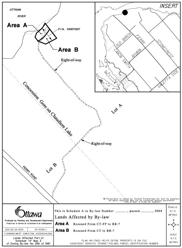
Zoning By-law amendment is located at 5532 Ferry Road with access to the
property via a private right-of-way off the east side of Ferry Road, north of
Alywin Road. The 0.76 hectare waterfront parcel is currently
the site of a seasonal dwelling. The
property is an existing lot of record which does not have frontage on an open
maintained public road. The private
right of way also serves as access to a second waterfront lot with a seasonal
dwelling and a much larger parcel of land which is owned by the Roman Catholic Archdiocese of Ottawa. The Archdiocese property, formerly known as Camp Echon, operated
as a summer camp in the late seventies through the eighties. The current land uses adjacent to
the site are the Ottawa River to the north and a hydro right-of-way to the
east. The lands to the west and south
are vacant and mostly tree covered.
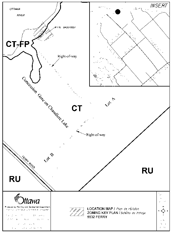
In the early eighties the former Township of West Carleton approved a Zoning By-law amendment to permit Camp Echon. The lands, approximately 93 ha. in size were rezoned to CT-FP Commercial Tourist-Flood Plain. Nestled within the larger parcel were the two lots of record previously which were included as part of the overall zoning of the summer camp. These lots currently enjoy a legal non-conforming right. The owner of one of these lots now wishes to have his lot recognized through a rezoning, as meeting all Zoning By-law requirements.
DISCUSSION
The subject lot is designated “Rural Natural Features and Flood Plain”
in the City Council Approved Official Plan.
The Official Plan of the former Region of Ottawa-Carleton designates the
property as “General Rural, Environmental Features and Flood Plain” and the
former Township of West Carleton Official Plan designates the lands as
“Marginal Resource, Hazard Lands and River Corridor”.
The owner proposes to demolish the existing seasonal dwelling which is
located in the flood plain and construct a fully detached dwelling house. The new structure is to be located in a cleared area of the lot outside the flood
plain.
Under the City Council Approved Official Plan, the subject lot is
currently designated as “Rural Natural Features”. According to section 3.2.4, a Zoning By-law amendment to change
the use or expand a use requires an Environmental Impact Statement (EIS) to
determine if development can occur with no adverse environmental impacts on the
rural natural feature.
According to the Mississippi Valley Conservation Authority (MVCA) flood
risk mapping, the current seasonal dwelling is situated within the Regulated
1:100 year flood plain. Ontario
Regulation 159/90 stipulates that development in areas susceptible to flooding
during a 1:100 year flood will generally not be permitted. It is recognized that the landowner intends
on demolishing the existing seasonal dwelling and replacing it with a fully
detached structure outside the flood plain.
The flood plain will be identified in the Zoning By-law amendment to
ensure that no development is permitted within this area.
In addition to the above, the MVC conducted a site visit on May 7,
2004. The MVCA discovered that a large
section of the wooded area had been cleared for what appeared to be a building
envelope. On June 28, 2004 City staff
conducted a site visit to the property and found that the majority of the site
had been cleared. The owner has
indicated that no further clearing of the existing lands will occur.
Staff reiterate that this is a previous developed lot of record that was
zoned improperly. Some development
rights have been established on this lot.
By means of the amendment proposed, standardly accepted setbacks will be
implemented and the floodplain recognized and protected. Prior to the issuance of a building permit
the owner will be required to demolish the existing structure.
ENVIRONMENTAL IMPLICATIONS
The owner has been advised that any further development or site clearing beyond what is proposed must be supported by an Environmental Impact Study (EIS). In addition, in order to limit the impact on the Rural Natural Feature, no additional buildings will be permitted within the required yards.
CONSULTATION
Notice of this application was carried out in accordance with the City's Public Notification and Consultation Policy. Information signs were posted on-site indicating the nature of the application. The Ward Councillor is aware of this application and the staff recommendation. The City did not receive any negative comments or opposition to this application.
FINANCIAL IMPLICATIONS
N/A
APPLICATION PROCESS TIMELINE STATUS
The application was not processed within the timeframe established for
the processing of Zoning By-law amendments due to the complexity of the issues
associated with the requirements of the
Conservation Authority. The
delay is also the result of workload volumes.
SUPPORTING DOCUMENTATION
Document 1 - Location Map
Document 2 - Explanatory Note
Document 3 - Details of Recommended
Zoning
DISPOSITION
Department of Corporate Services, Secretariat Services to notify the owner Mrs. Suzanne Potter, 66 Aylmer Avenue, Ottawa, Ontario K1S 2X3, applicant Mr. Steve Cunliffe, 200 Catherine Street 6th Floor, Ottawa, Ontario K2P 2K9, All Signs, 8692 Russell Road, Navan, ON K4B 1J1, and the Program Manager, Assessment, Department of Corporate Services of City Council's decision.
Planning and Growth Management Department to prepare the implementing by-law, forward to Legal Services Branch and undertake the statutory notification.
Department of Corporate Services, Legal Services Branch to forward the implementing by-law to City Council.
LOCATION MAP Document
1
EXPLANATORY NOTE Document
2
By-law Number 2004- Zoning By-law 266 of 1981 of the former Township of West
Carleton. The amendment affects the
property at 5532 Ferry Road, which is located via a private right-of-way with
access of the east side of Ferry Road north of Alywin Road.
The application is to rezone the subject
property from Tourist Commercial (CT) and Tourist Commercial Flood Plain
(CT-FP) to Rural Residential Exception (RR-**) and Rural Residential Flood
Plain (RR-FP). The amendment will
permit a fully detached dwelling house and; permit development of a lot without
opened and maintained public road frontage.
For further information please, contact Jeff
Ostafichuk at 580-2424 ext. 31329.
DETAILS OF RECOMMENDED ZONING Document 3
That the Tourist Commercial Flood Plain (CT-FP) zone at 5532 Ferry Road be amended to a Rural Residential Flood Plain (RR-FP) zone; and
That the Tourist Commercial (CT) zone at 5532 Ferry Road be amended to a Rural Residential exception zone (RR-**), with the following provisions:
- Building Setback, Front (minimum): 6.0 m from the zone boundary
- Building Setback, Side (minimum): 6.0 m
- Building Setback, Rear (minimum): 10.0 m
- No buildings any kind will be permitted within required building setbacks.
- Street Access: Frontage on an opened and maintained public road is not required.
- A private sewage system may be located within the rear and side yard building setbacks.