Report to/Rapport au :
Planning and Environment Committee
Comité de l'urbanisme et de
l'environnement
and Council / et au Conseil
14 July 2004 / le 14 juillet 2004
Submitted by/Soumis par : Ned Lathrop, Deputy City Manager / Directeur
municipal adjoint
Planning and Growth Management / Urbanisme et
Gestion de la croissance
Contact Person/Personne ressource : Grant Lindsay,
Manager / Gestionnaire
Development Approvals / Approbation des demandes d'aménagement
(613) 580-2424 x13242, Grant.Lindsay@ottawa.ca
|
SUBJECT: |
|
|
|
|
|
OBJET : |
REPORT RECOMMENDATION
That the Planning and Environment Committee recommend Council approve an
amendment to the former City of Ottawa Zoning By-Law to change the zoning of
1440 Bank Street from a commercial CD F(2.0) zone, a commercial CD3 F(2.0)
H(15.24) zone and residential R3A zone to a commercial CD F(2.0) exception zone
as shown on Document 1 and detailed in Document 3.
RECOMMANDATION DU RAPPORT
Que le Comité de l'urbanisme et de l'environnement recommande au Conseil d'approuver une modification au Règlement de zonage de l'ancienne Ville d'Ottawa afin de changer la désignation de zonage commercial CD F(2.0), commercial CD3 F(2.0) et résidentiel R3A du 1440, rue Bank par la désignation de zonage commercial CD F(2.0) assorti d'une exception, tel qu'il est indiqué dans le Document 1 et expliqué dans le Document 3.
BACKGROUND
The subject property comprises part of a former Canadian Pacific Railway Right-of-Way. The site is currently vacant and has three zoning designations (CD F(2.0), CD3 F(2.0) H(15.24) and R3A). The applicant, who owns the adjacent commercial plaza located to the east, recently has purchased the subject site and wishes to construct a new commercial plaza next to the existing one. These commercial plazas would be independent of each other. To accommodate this proposal the applicant is requesting that a single CD F(2.0) exception zone, be applied to the entire site.
DISCUSSION
Council Approved Official Plan
The City Council Approved Official Plan designates the subject property
as Mainstreets. This designation
anticipates a lively mix of commercial uses serving both the local needs and a
larger market. The proposed zoning to
establish a single commercial zone, which will increase the commercial
development potential, will allow for a wide range of uses that meets this
intent.
Lands with the Mainstreets designation offer some of the most
significant opportunities for renewal through more concentrated forms of
development. The City will support
projects that achieve a more urban, densely developed form within Mainstreets,
in a manner that sensitively builds on existing neighbourhoods and is less
auto-dependant. Over time, it is the
City's intent that Mainstreets will consolidate into uninterrupted networks of
active, mixed-use, pedestrian oriented development. The proposed rezoning will
allow a vacant property along Bank Street, which is a busy commercial street,
to be constructed with a building which will increase the density of existing
development and allow the site to become part of the continuous urban fabric
anticipated by this designation.
Development in Mainstreets is eventually to be guided through a
Community Design Plan. In the meantime,
however, development is permitted, provided the proposal satisfies relevant
policies. Relevant policies for this
property include ensuring that the redevelopment of underutilized land is
optimized, permitting community serving uses and considering the extent to which
the proposal will contribute to a diversity of land uses in the area and the
ability to live, work and play. The
proposed zoning satisfies the intent of these policies as it will permit the
development of underutilized land and provide for a range of permitted uses on
the entire site, which will add to the
diversity of land uses in the area.
In addition to the policies mentioned above, development in areas
designated Mainstreets must also satisfy the policies in Section 2.5.1. of the
new Official Plan. This section relates
to ensuring the compatibility of a proposed development with surrounding
properties. While many of the
compatibility factors relate to considerations that would be addressed through
the Site Plan Control Process, there are policies relevant to zoning. In this regard, the proposed rezoning is
located on an arterial road with sufficient capacity to accommodate the
proposal's anticipated traffic. As well,
rezoning the property will allow a development with a variety of uses, which will
diversify the land use and activity in the surrounding area. Development of this site will also help
consolidate Mainstreets as it will develop an existing vacant space on the
street. Given the small area of the
property and the allowable floor space index, the size of any development will
respect the height and massing of other developments in the general area,
including the residential development to the west.
Former Regional Official Plan
The Official Plan of the former Region designates the subject lands as
"General Urban Area". Lands
with this designation are to be used for primarily residential purposes,
supportive shopping services and community facilities. The proposed rezoning will permit a
development that satisfies these policies in the former Regional Official Plan
as it will provide for commercial uses which can serve the surrounding
residential neighbourhood.
Former City of Ottawa Official Plan
The former City of Ottawa Official Plan designates the subject property
as District Linear Commercial. This
designation anticipates a wide variety of commercial uses which traditionally
attract a significant percentage of their customers from beyond the local area
as well as from local pedestrian traffic.
While the existing portion of the property zoned District Commercial
will allow uses which meet the intent, rezoning the section presently zoned R3A
will integrate the whole property with the adjacent commercial lands and allow
for a more rational development of site.
In this regard, there is very little opportunity to develop the R3 lands
as part of the adjacent residential community.
This community is fully developed with dwellings that back onto the R3
lands.
The District Linear Commercial designation anticipates that buildings
are pedestrian oriented. The subject
property parallels Bank Street and is narrow.
Combining the R3 zoned lands with the Commercial Lands provides an
opportunity for the site to be developed with buildings close to Bank Street,
to help facilitate easy pedestrian access and thereby meeting the intent of
this policy, while also providing for appropriate buffering for the adjacent
residential lands.
Details of Proposed Zoning
In addition to the recommended parent zone, the applicant is also
requesting certain modifications to performance standards. These include a reduction in the required
side yard to 1.75 metres, providing no designated loading space and not
requiring a designated three metre landscape strip abutting a street. In the case of the requested side yard
reduction and the landscape open space requirement, their impact can be
mitigated through the Site Plan Control process. The impact of a reduced side yard on the community can be
addressed by the requirement for vegetation and/or an opaque fence. While the minimum requirement of a three
metre landscape strip will be provided along the majority of the width of the
Bank Street frontage, where some parking is proposed, this is not possible. In this instance, the landscaping is to be
provided on the City Boulevard, which is consistent with the adjacent commercial property. With respect to the designated loading space, loading can be
provided on site around the proposed building, without the need for a
dedicated space. Given the foregoing, in each of these
instances, it is the Department's position that the proposed modifications to
the performance standards will not be detrimental to the surrounding community,
or to the orderly development of the site.
CONSULTATION
Notice of this application was carried out in accordance with the City's Public Notification and Consultation Policy. Information signs were posted on-site indicating the nature of the application. Two responses were received as a result of the posting of the on-site sign. Each of the respondents was interested in the timing for construction. The Ward Councillor is aware of this application and the staff recommendation.
FINANCIAL IMPLICATIONS
N/A
APPLICATION PROCESS TIMELINE STATUS
The application was not processed within the timeframe established for
the processing of Zoning By-Law amendments due to a need to address Site Plan
issues related to access and storm water management, which impacted the
developability of the site for the use intended. As these have been resolved, the application is proceeding to the
first available Planning and Environment Committee meeting.
SUPPORTING DOCUMENTATION
Document 1 - Location Map
Document 2 - Explanatory Note
Document 3 - Details of Recommended Zoning
DISPOSITION
Department of Corporate Services, Secretariat Services to notify the owner (Al Gossen
43 Rosemount Avenue Ottawa, Ontario K1Y 1P3), applicant (Ewald Zieger, 100 Cherry Hill Drive, K0A 1L0), All Signs, 8692 Russell Road, Navan, ON K4B 1J1, and the Program Manager, Assessment, Department of Corporate Services of City Council's decision.
Planning and Growth Management Department to prepare the implementing by-law, forward to Legal Services Branch and undertake the statutory notification.
Department of Corporate Services, Legal Services Branch to forward the implementing by-law to City Council.
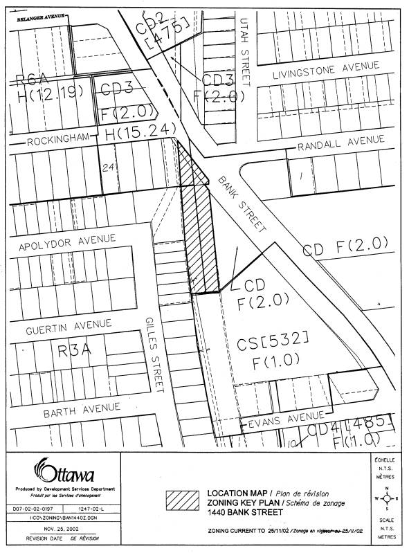
LOCATION MAP Document
1
EXPLANATORY NOTE Document
2
THE FOLLOWING IS AN EXPLANATORY NOTE TO BY-LAW
NUMBER
By-law Number ……… amends By-law Number, 93-98,
the former City of Ottawa's Comprehensive Zoning By-law. This amendment affects the lands located at
1440 Bank Street, located on the west side of Bank Street, generally across
from Randall Avenue. The subject lands
are a former Canadian Pacific Rail Right-of-Way.
Current Zoning
The subject property is currently triple zoned;
CD F(2.0), CD3 F(2.0) H(15.24) and R3A.
The CD zones are District Linear Commercial Zones which are typically
found in commercial areas along major roads.
The R3A zone is a low density residential zone. The CD F(2.0) zone occupies over half the
property while the R3A zoning occupies slightly less than half of the site and
the CD3 F(2.0) zone occupying only a small portion. Both CD zones allow a wide variety of commercial uses and
residential uses above the ground floor.
The number "3" represent a subzone. This subzone allows the entire floor space index to be used for
commercial purposes. The H(15.24) indicates the height limit, which in this
instance is 15.24 metres. The F(2.0)
represents the floor space index, which in this instance indicates that the
floor area of buildings on the property may be twice the area of the lot. The R3A zoning permits such uses as single
detached dwelling, a semi-detached dwelling and a duplex. The letter "A" represents a
subzone that limits the size of lots for residential development. This zone presently occupies the portion of
the property on the majority of the western boundary of the site.
Proposed Zoning
The proposed zoning for the entire property is
a CD F(2.0) exception zone. This is a
District Linear Commercial zone that will facilitate the development of a
commercial plaza on the property. The
exception modifies to certain performance standards. These include reducing the required side yard to 1.75 metres, not
requiring a minimum landscape strip along Bank Street and not providing a
loading space.
For further information, please contact Douglas
James of the Planning and Infrastructure Approvals Branch at 580-2424 extension
13856.
DETAILS OF RECOMMENDED ZONING Document 3
The property will be zoned CD F(2.0), with the following exceptions:
1. The required side yard shall be 1.75 metres
2. No loading space is required.
3. A parking lot may be located adjacent to a lot line abutting a public street and there is no requirement for a three metre landscape strip along the parking lot.