Report to/Rapport au :
Planning and Environment Committee
Comité de l'urbanisme et de
l'environnement
and Council / et au Conseil
30 January 2004 / le 30 janvier 2004
Submitted by/Soumis par : Ned Lathrop, General
Manager/Directeur général,
Planning and Development/Urbanisme et
Aménagement
Contact Person/Personne
ressource : Karen Currie, Manager / Gestionnaire
Development Approvals / Approbation des demandes
d'aménagement
(613) 580-2424 x28310, Karen.Currie@ottawa.ca
REPORT RECOMMENDATION
That the Planning and Environment Committee
recommend that Council:
1. Approve
and adopt an amendment to the Official Plan of the former City of Nepean to
redesignate 800 Cedarview Road from General Rural Area to Country Lot and Open
Space, as detailed in Document 2.
2. Approve
an amendment to the former City of Nepean Zoning By-law 73-92 to change the
zoning of 800 Cedarview Road from RU, Rural Agricultural Zone, to RCL,
Residential Country Lots Zone, and RCL Block "A", Residential Country
Lots Zone, to permit development of detached family dwellings and to Con,
Conservation Zone, and to Con, Conservation Zone Block "A", to enable
the preservation of wetlands and wetland buffer that will also function as a
flood control facility, as shown in Document 3 and detailed in Document 4.
3. Authorize
the Director of Planning and Infrastructure Approvals to grant draft plan
approval to the proposed Plan of Subdivision pertaining to Part of Lots 22, 23,
24 and 25, Concession 4 (Rideau Front), Geographic Township of Nepean, formerly
City of Nepean, now City of Ottawa, as shown on Document 5, subject to the
conditions detailed in Document 5.
RECOMMANDATION DU RAPPORT
Que le Comité
de l'urbanisme et de l'environnement recommande au Conseil municipal :
1. approuve et adopte une modification au
Plan officiel de l'ancienne Ville de Nepean en vue de faire passer le zonage du
800, chemin Cedarview de zone rurale générale à zone de résidence de campagne
et à zone d'espaces ouverts, comme le précise le document 2.
2. approuve une modification au Règlement
municipal no 73-92 de l'ancienne Ville de Nepean en vue de faire passer le
zonage du 800, chemin Cedarview de zone agricole rurale (RU) à zone de
résidence de campagne et à zone de résidence de campagne (RCL) bloc A en vue de
permettre l'aménagement de maisons jumelées unifamiliales, et à zone de
conservation (Con) et à zone de conservation (Con) bloc A, en vue de permettre
la préservation des terres humides et d'une zone tampon autour des milieux
humides serviront d'installation de maîtrise des crues, comme l'illustre le
document 3 et le précise le document 4.
3. autorise le directeur de l'Approbation
des demandes d'urbanisme et d'infrastructure d'accorder l'approbation du plan
provisoire visant la proposition de lotissement ayant trait à la partie des
lots 22, 23, 24 et 25, concession 4 (façade Rideau), canton géographique de
Nepean, ancienne Ville de Nepean et maintenant la Ville d'Ottawa, comme
l'illustre le document 5, sous réserve des conditions décrites dans le document
5.
BACKGROUND
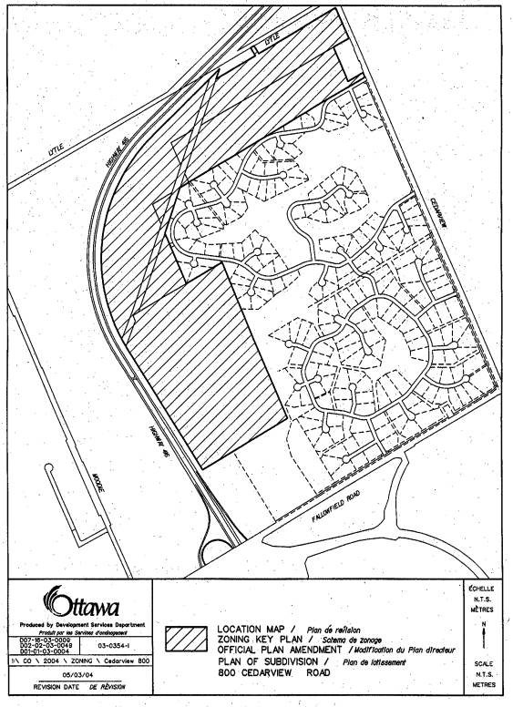
The subject property is located east of Highway 416, north of Strandherd Drive and Fallowfield Road, and west of Cedarview Road. This is an "L" shaped parcel of land that runs along the east side of Highway 416 and is adjacent to the Cedarhill Estates and Orchard Estates residential subdivisions. This parcel of land has an area of 113.61 hectares. Some of the features of this site include an abandoned old quarry at the most westerly portion of the property, and a wetland at the easterly portion of the property that is designated as a Provincially Significant Wetland Area by the former Regional Official Plan. The property is also divided by a 12 metre wide hydro corridor that runs across the northwesterly portion of the site. There is a city park and vacant land to the south. To the north is Lytle Avenue which is developed with detached family dwellings.
Purpose of the Official Plan and Zoning By-law Amendments
The purpose of these applications is to permit the development of a country-estate residential subdivision. Proposed are 95 country-estate lots that will be unserviced, requiring private water and septic systems. The proposed Official Plan and Zoning amendments are to the former City of Nepean Official Plan to redesignate the property from General Rural Area to Country Lot and Open Space, and to rezone the property from Rural Agricultural Zone, to RCL, Residential Country Lots Zone, and Con, Conservation Zone. This will allow development of detached family dwellings, and the preservation of wetlands that will also function as a flood control facility.
The exceptions to the residential and conservation zonings will allow reduced lot widths in order to accommodate irregular shaped parcels of land, correct a zoning anomaly in the parent RCL zone to reflect a minimum lot area requirement of 0.8 hectares, and incorporate privately owned conservation lands as part of the lot area.
DISCUSSION
These applications were received prior to April 23, 2003, and, as such, are subject to existing municipal policies prior to that date.
Former Region of Ottawa-Carleton and City of Nepean Official Plans
This property is designated as General Rural Area in Schedule "A" of the Rural Policy Plan of the former Regional Official Plan. The intent of the General Rural Area is to allow non-farm related uses on lands considered to have less resource potential that other parts of the rural area. The plan permits residential development to occur on larger residential country lots having a minimum area of 0.8 hectares (two acres) provided that the development is sensitive to the landscape and environment.
The former City of Nepean Official Plan further directs that residential development on lands designated General Rural Area by the former Regional Official Plan, maintain and not dominate the rural landscape. Conflicts between future rural/agricultural uses and residential uses are minimized, and natural wetlands and woodlots are to be protected. Additionally, residential development shall be designated as Country Lot in the former City of Nepean Official Plan, provided such development does not place demands for urban services and relies totally on private water and septic systems. These residential development proposals are required to provide detailed hydrogeological and terrain analysis to ensure the long term viability of the development prior to their approval.
City Council Approved Official Plan
This property is designated as "General Rural Area" in Schedule "A" of the Rural Policy Plan. The intent the General Rural Area is permit land uses that are considered to be characteristic and supportive of the rural community. This designation does permit Country Estate development.
Rationale
The Official Plan and Zoning By-law Amendments have been reviewed in conjunction with the subdivision application and it was determined they comply with the above policies. Proposed through the zoning amendment is a Conservation Zone for publicly and privately owned conservation lands. The propose of the Conservation Zone is to ensure the protection of the significant wetland area and the provision of an adequate vegetative buffer to that wetland, ensuring its viability. The registered subdivision will contain covenants for privately owned conservation lands prohibiting any physical alteration to those lands including the removal of any vegetation. A preliminary Tree Planting and Conservation Plan has been submitted identifying significant wooded areas to be protected. A finalized plan will be required prior to subdivision registration. Further, the subdivision will be phased in order that it can be demonstrated that the existing wells and private sewage disposal systems are functioning in a satisfactory manner, including an assessment of water quality in the shallow aquifer, prior to the registration of the second phase.
Compatibility
The predominate land use in the area can be characterized predominately detached country estate lot residential with some neighbouring public and private recreational uses. There are no lands within the immediate or surrounding area whose function is agricultural or supportive of an agricultural use. As such, the proposed subdivision will not be in conflict with Official Plan directives requiring residential development not detract from the overall rural agricultural landscape, nor will there be potential for conflicts between future rural/agricultural uses and the proposed residential uses.
Design
The design of this subdivision resulted from extensive consultation with the neighbouring Orchard Estates and Cedarhill Community Associations, facilitated by the applicant and the Ward Councillor. The subdivision proposal includes pathway linkages to existing stone dust pathways and a linkage to the an existing city park to the south. The proposed street connection at the most easterly end of Cedarhill Drive is designed to have minimal traffic impacts into Cedarhill Community and is aligned to an existing street within the Cedarhill Community to avoid the need for an additional intersection along Cedarhill Drive.
Noise
The westerly and northwesterly portion of this site abuts Highway 416. A Noise Assessment Study was conducted for this property recommending that a noise attenuation feature consisting of a berm be constructed along the westerly edge of the subdivision. The assessment concluded that no window or wall upgrades beyond the Ontario Building Code standards were required but did recommend a warning clause with respect to daytime noise levels from Highway 416 may exceed 60 dBA, which has been included in the conditions of draft subdivision approval.
ENVIRONMENTAL IMPLICATIONS
The Rideau Valley Conservation Authority has reviewed the zoning and subdivision applications and has no objections to these applications proceeding to approval. Issues relating to the wetland area have been dealt with though draft conditions of subdivision approval.
CONSULTATION
Notice of this application was carried out in accordance with the City's Public Notification and Consultation Policy. Information signs were posted on-site indicating the nature of the application. The Ward Councillor is aware of this application and the staff recommendation. The City did receive a number of negative comments and one resident in opposition to this application.
Staff circulated the proposed Official Plan and Zoning By-law amendments, as well as Plan of Subdivision application, to various technical agencies and City Departments. A number of information meetings were held in the community. Detailed responses to the notification/circulation are provided in Document 7.
FINANCIAL IMPLICATIONS
N/A
APPLICATION PROCESS TIMELINE STATUS
This application was not processed within the timeframe established for
the processing of Official Plan Amendments, Zoning Amendments or Subdivision
Approval due to the complexity the technical review relating to the wetlands.
SUPPORTING DOCUMENTATION
Document 1 - Location
Map
Document 2 - Proposed
Official Plan Amendment
Document 3 - Zoning
Map
Document 4 - Zoning
Amendment Details
Document 5 - Draft
Conditions for Subdivision Approval
Document 6 -
Draft Plan of Subdivision
Document 7 - Consultation
Details
DISPOSITION
Department of Corporate Services, Secretariat
Services to notify the owner, Robert Swaita, 34 Taj Court, Ottawa, ON, K1G 5K6,
applicant, FoTenn Consultants Inc., 223 McLeod Street, Ottawa, ON, K2P 0Z8, All
Signs, 8692 Russell Road, Navan, ON K4B
1J1, and the Program Manager, Assessment, Department of Corporate Services of
City Council's decision.
Department of Planning and Development to prepare
the implementing by-law and forward to Legal Services Branch, and undertake the
statutory notification amendment to the Zoning By-Law 1998 of the former City
of Nepean Zoning By-Law.
Department of Corporate Services, Legal Services
Branch to forward the implementing by-law to City Council.
LOCATION MAP Document
1
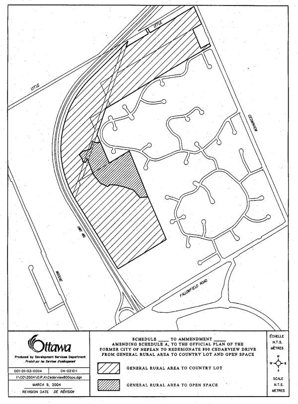
PROPOSED OFFICIAL PLAN AMENDMENT Document 2
Official Plan Amendment __ /Modifications du Plan directeur
To the Official Plan of the former City of Nepean, now forming part of the City of Ottawa Official Plan
Land use
Utilisation du sol
_______________________________________________________________________
INDEX
________________________________________________________________________
The Statement of Components
PART A - THE PREAMBLE
Purpose
Location
Basis
PART B- THE AMENDMENT
Introductory Statement
Details of the Amendment
Implementation and Interpretation
PART C - APPENDIX
Appendices
THE STATEMENT OF COMPONENTS
PART A - THE PREAMBLE, introduces the actual Amendment but does not constitute part of Amendment No. __ to the former City of Nepean, April 2004.
PART B - THE AMENDMENT, consisting of schedule changes constitutes the actual Amendment No. __ to the former City of Nepean, April 2004.
PART C - APPENDIX, does not form part of the Amendment but is provided to clarify the intent and to supply background information related to the Amendment.
PART A - THE PREAMBLE
Purpose
The purpose of Amendment __ is first to amend Schedule "1" of the Official Plan from General Rural Area to Country Lot and Open Space.
Location
The property is located east of Highway 416, north of Strandherd Drive and Fallowfield Road, and west of Cedarview Road. This parcel of land has an area of 113.61 hectares. Surrounding area development consists of residential development along Lytle Avenue, Cedarhill Estates and Orchard Estates residential subdivisions, and the Cedarhill Golf Course to the east and a city recreational park and vacant land to the south, and Highway 416 to the west. The property is also divided by a 12 metre wide hydro corridor that runs across the northwesterly portion of the site.
Basis
The subject property is designated as General Rural in the former Regional Municipality of Ottawa-Carleton and is subject to the Rural policies contained in the former City of Nepean Official Plan. In the Regional Official Plan the General Rural designation is for lands that have less resource potential than other parts of the rural area. The plan permits residential development with the General Rural designations on large country estate lots of not less than 0.8 hectares provided there is evidence of satisfactory private water and septic services on site.
The Rural policies contained within the former City of Nepean Official Plan permits limited cluster residential development on lands designated as Country Lot (CL) and allows for alternative non-urban residential development. The Country Lots designation is considered appropriate provided it does not detract from the predominate agricultural function of the Rural Area. Additionally, any proposal to designate lands shall have regard to the protection of areas of natural heritage, such as wetland in this case.
A conceptual stormwater management plan, and a terrain analysis and hydrogeological study was submitted with the subdivision application. These studies demonstrated that the subject lands can support the subdivision proposal for 95 privately serviced lot. Additionally, a review of the proposal was found to be in keeping with the overall intent of the applicable Official Plan policies and guidelines for country lot subdivision development.
PART B - THE AMENDMENT
1. Introduction
All of this part of the document entitled Part B - The Amendment, consisting of the following attached maps designated Schedule "1" of the Official Plan constitutes Amendment __ to the Official Plan of the former City of Nepean.
2. Details
The following changes are hereby made to the Official Plan of the former City of Nepean, as amended from time to time:
1. That the area identified in Document 1 be amended from a General Rural Area to Country Lot and Open Space designations in Schedule "1" of the Official Plan.
IMPLEMENTATION AND INTERPRETATION
Implementation and Interpretation of this Amendment shall be made having regard to applicable policies of this Plan.
PART C - APPENDIX
N/A
Schedule "1" - MAP
ZONING MAP Document
3
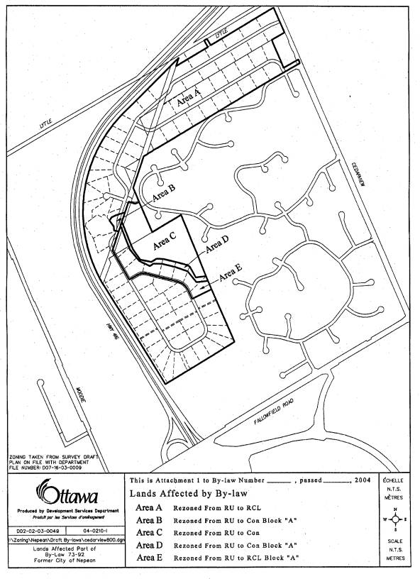
ZONING AMENDMENT DETAILS Document
4
1. That Areas 1 and 2 be rezoned from RU, Rural Agricultural Zone, to RCL, Residential Country Lots Zone and RCL Block “A”, Residential Country Lots Zone, with Block “A” denoting the following exception to the standard RCL zone:
7.4 Exceptions
1. Despite Section 7.2 on lands zoned RCL Block “A” the following applies:
a) the minimum lot frontage shall be 21.5 metres,
b) the minimum lot area shall be 0.8 hectares (two acres)
c) adjacent lands zoned Conservation Block “A” can be included in the calculation of lot area.
2. That Areas 3 and 4 be rezoned from RU, Rural Agricultural Zone, to Con, Conservation Zone, and Con Block “A”, Conservation Zone, with Block “A” denoting the following exception to the standard RCL zone:
9.6 Exceptions
1. That lands zoned Con Block “A” can be included in the calculation of lot area for adjacent lands zoned RCL Block “A”.
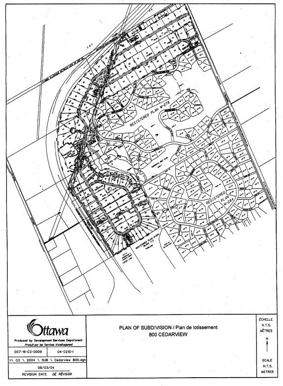
DRAFT CONDITIONS OF SUBDIVISION APPROVAL Document
5
File: D07-16-03-0009
DRAFT PLAN OF SUBDIVISION CONDITIONS FOR APPROVAL
EMERALD ESTATES SUBDIVISION,
The City of Ottawa’s conditions applying to the approval of the draft plan of subdivision for Fotenn Consultants Inc. – Emerald Estates Subdivision (D07-16-03-0009) are as follows:
|
|
General |
|
|
1. |
This
approval applies to the draft plan of subdivision of Part of Lots 22, 23, 24
and 25 Concession 4 (Rideau Front), Geographic Township of Nepean (formerly
City of Nepean), now in the City of Ottawa, certified by Annis, O’Sullivan,
Vollebekk Ltd. – Ontario Land Surveyors, dated xx as received, showing 95
lots for single detached dwellings, one block for drainage (Block 118 and 119
from quarry), one block for stormwater management, conservation blocks
adjacent to lots 57 to 62 (Blocks 109 through to 116), two blocks for 0.3 m
reserves (Blocks 98 and 99), seven blocks for walkways (Blocks 97, 104, 105,
106, 107, and 108) and one block for a potential future street (Block 96). |
City (PDD) |
|
2. |
City (PDD) |
|
|
3. |
The development of this subdivision will be phased. Each phase is to contain not more than 40 lots. Prior to the registration of each phase subsequent to the first phase, a report, prepared by a qualified professional, has to submit to the City of Ottawa to demonstrate that the existing wells and private sewage disposal systems are functioning in a satisfactory manner. The report shall include an assessment of water quality in the shallow aquifer, based on the direction of flow. Further, the Owner agrees that prior to the registration of each phase, lots in that phase or subsequent phase will not be offered for sale, nor will the Owner apply for building permits. |
RVCA/City (PDD) |
|
4. |
The Owner shall provide certification from an Ontario Land Surveyor that each lot on the draft 4M plan is a minimum of 0.8 hectare. This minimum lot area is required to provide nitrate dilution associated with the operation of private sewage disposal systems, and to comply with zoning provisions. |
RVCA/City (PDD) |
|
5. |
The Owner shall obtain such permits as may be required from Municipal or Provincial authorities and shall file copies thereof with the Director, Planning and Infrastructure Approvals. |
City (PDD) |
|
6. |
The Owner shall be responsible for the
provision of the following services, including over-sizing, at its cost, to
the satisfaction of the City and/or the Province: a) storm drainage system b) roads c) street lights d) landscaping e)
street
name and traffic signs. |
City (PDD) |
|
7. |
The Owner shall be required to provide 1.8 metre high black mesh chain link fencing on private property along that portion of the road allowance that is adjacent to an abandoned privately-owned quarry as required by the City of Ottawa. The black mesh chain link fencing may be substituted with decorative metal fencing subject the concurrence of the Director, Planning and Infrastructure Approvals. |
City (PDD) |
|
8. |
The Owner shall submit a geotechnical study prepared by a qualified professional engineer which will include but not be limited to recommendation with respect to roadway design, building footings and foundations, the stability of the slopes into the abandoned quarry and the suitability of the existing fill material on-site for use within the development. |
City (PDD) |
|
9. |
Prior to the registration of this subdivision, the Owner shall acquire the necessary lands with the Hydro Corridor for conveyance to the City of Ottawa in order to provide roadway and emergency vehicle connections acceptable to the Director, Planning and Infrastructure Approvals. Such lands shall be incorporated as public roads on the final 4M-Plan prior to registration. |
City (PDD) |
|
10. |
Prior to the registration of this subdivision, the Owner may be required to realign Street Number 1 to provide a separation between the road allowance and Block 100 at the request of and to the satisfaction of the Director, Planning and Infrastructure Approvals. |
City (PDD) |
|
11. |
That the Owner provide a guide rail along any portion of the Street Number 1 where it abuts Block 100, to the satisfaction of Director, Planning and Infrastructure Approvals. |
|
|
12. |
Prior to the registration of this subdivision, the Owner shall provide evidence satisfactory to the Director, Planning and Infrastructure Approvals that there are no outstanding collect backs or encumbrances associated with a 30 centimeter reserve along Cedarhill Drive that would prevent the lifting of the reserve, and therefore restrict vehicular access from Cedarhill Drive to Street Number Two. |
City (PDD) |
|
13. |
That the 0.3 metre reserve abutting Cedarhill Drive and Street Number 2 shall be lifted, at the expense of the Owner. |
|
|
|
Fire |
|
|
14. |
The Owner undertakes and agrees to provide and erect or affix, at their expense, such municipal number signs, illuminated or otherwise, in such locations and of such a size, design and colour as submitted to and approved by the Fire Chief of the City of Ottawa prior to occupancy of any buildings, or part thereof, in the subject development, and that any such numbering shall be visible from the street during both day and night. |
City (Fire) |
|
15. |
a) That all off-site fire hydrants must be fully operational prior to any structural framing and be maintained accessible and operational at all times. b) Where no municipal hydrants are available, the Owner will provide alternate means of water supply for approval as required in Section 3.2.5.7 of the Ontario Building code. |
City (Fire) |
|
16. |
That public street access must be provided by a road complete with first lift of asphalt prior to combustible framing. Alternatively, at time of the year when asphalt plants are not operational, the minimum road construction must be sub base with full depth base material, topped with granular “A”: gravel or within 2” of finished grade. |
City (Fire) |
|
17. |
That all on-site roadways be accessible for emergency vehicles at all times during construction (i.e. clear of any and all obstructions). |
City (Fire) |
|
18. |
That on-site roadway are to be constructed to meet the design requirements of Section 3.2.5.6 of the Ontario Building Code, as amended from time to time for fire access route, where applicable. |
City (Fire) |
|
19. |
That five (5) copies of final site plan be submitted to Fire Department for official designation of fire access route, where applicable, per City By-law, as amended from time to time. |
City (Fire) |
|
20. |
That the Owner shall meet all the requirements of the City’s Fire Department with respect to the identification, maintenance, snow removal and signing of fire routes. |
City (Fire) |
|
21. |
That written confirmation, at time of building permit application, of the building classification to be used for construction be provided to the Fire Department as specified in Articles 3.2.2.20 and 3.2.2.83 of the Ontario Building Code. |
City (Fire) |
|
22. |
That a plan showing proposed Fire Department connections, annunciator panel and off-site hydrant locations be submitted to the fire Department for comment/approval. |
City (Fire) |
|
|
Zoning
and Official Plan |
|
|
23. |
Prior
to registration of the plan of subdivision, the proposed plan of subdivision
must conform with the local Official Plan and a Zoning By-law approved under
the requirements of the Planning Act, with all possibility of appeal to the
OMB exhausted. |
City (PDD) |
|
|
Parks |
|
|
24. |
The
Owner shall convey Block 103 to the City for park purposes. The Owner shall pay the City cash-in-lieu
of the 5% of the land included in the plan of subdivision, minus the area of
Block 103. Such amount shall be
determined by the Director, Planning and Infrastructure Approvals. |
City (PDD) |
|
25. |
The Owner shall design and construct a basketball court that incorporates a portion of the paved pedestrian pathway leading from Cedarhill Drive to Street Number One, to the satisfaction of the Director, Planning and Infrastructure Approvals. |
City (PDD) |
|
|
Sidewalks,
Walkways and Fencing |
|
|
26. |
The Owner agrees to convey at no cost to the City Blocks 97, 102, 104, 105, 106, 107, 108, having a minimum widths of 6.0 metres, for pedestrian walkways. |
City (PDD) |
|
27. |
The Owner agrees to design, and construct paved pedestrian walkways within Blocks 97, 104, 105, 106 and 107 to the satisfaction of Director, Planning and Infrastructure Approvals. This design shall include, but not be limited to marker lights at roadway intersections, split rail cedar fencing, and plant material. |
City (PDD) |
|
28. |
The Owner agrees to convey at no cost to the City Block 102 for the construction of a pedestrian walkway/emergency vehicle access. |
City (PDD) |
|
29. |
The Owner agrees to design and construct paved pedestrian pathway/fire lane leading from Cedarhill Drive, through Block N on Plan 4M-278, Block 102 on the draft plan of subdivision and the Hydro Corridor, and connecting with Street Number 1, to the satisfaction of Director, Planning and Infrastructure Approvals. This design shall include, but not be limited to marker lights at the intersections of public streets, split rail cedar fencing, plant material and break-away bollards. |
City (PDD) |
|
30. |
Prior to the registration of the subdivision, the Owner shall use best efforts in acquiring a pedestrian surface easement over the Hydro Corridor identified on the draft plan of subdivision that will in turn be then conveyed City of Ottawa. |
City (PDD) |
|
31. |
The Owner shall submit and implement a pedestrian walkway plan that reflects walkway realignments resulting from the construction of Street Number 1 within the Hydro Corridor and implement the necessary associated works of the walkway realignment to the satisfaction of the City of Ottawa. |
City (PDD) |
|
32. |
The Owner acknowledges and agrees that Blocks 97, 102, 104, 105, 106, 107 and 108 for walkway dedication, and Block 101 for stormwater management purposes do not form part of the parkland dedication calculation. |
City (PDD) |
|
|
Archaeology
|
|
|
33. |
The Owner shall adhere to the procedures of the “Contingency Plan for the Protection of Archaeological Resources in Urgent Situation” as approved by the Ministry of Citizenship, Culture and Recreation in the archaeological Resource Potential Mapping Study of the City. |
City (PDD) |
|
|
Tree
Preservation |
|
|
34. |
Prior to final registration, a revised Tree Planting and Conservation Plan is to be prepared to the satisfaction of the City of Ottawa and the Rideau River Conservation Authority and must clearly demonstrate how residual trees along the side and rear yard lot lines are to be protected, such that potentially only 25 percent of the surface area of each individual lot on the subject property is physically disturbed/altered in the development process. The plan shall include in tree protection the following clause: “Waste of volatile materials, such as mineral spirits, oil or paint thinner shall not be disposed of with dripline of a tree. Emissions from equipment shall not be directed in such a way as to come into contact with the foliage of a tree. Flooding or deposition of sediment shall be prevented where located.” In addition, the revised report shall include a satisfactory wildlife “escape route” to be maintained adjacent to natural areas throughout all tree removal and construction activities. |
RVCA/City (PDD & TUPW) |
|
35. |
The Owner shall to eliminate safety hazards, any future
privately-owned trees or woodlands adjacent to Lots 47 and Lots 57 to 61 inclusive
must be pruned and/or removed under supervision by Forestry staff prior to conveyance, to the satisfaction of the City of Ottawa. |
City
(TUPW) |
|
36. |
The Owner agrees to develop each lot in accordance with the findings and recommendations of the detailed Tree Planting and Conservation Plan and to inform future Purchasers regarding their obligation to implement the specific tree saving measures applicable to the lot they are purchasing, through all Offers of Purchase and Sale and Agreements, to the satisfaction of the City of Ottawa. |
RVCA/City (PDD & TUPW) |
|
37. |
That the Tree Preservation Plan approved by the Planning and Development Department and the Rideau Valley Conservation Authority shall become part of the contract documents package issued for tender and construction purposes. |
RVCA/City (PDD) |
|
|
Highways/Roads |
|
|
38. |
The design of all road intersections, including geometric, intersection spacing, grades, the conveyance of the necessary sight triangles and required 0.3 m reserves necessary for lot access control (Blocks 98 and 99), shall be to the satisfaction of the Director of Planning and Infrastructure Approvals. |
|
|
39. |
The Owner agrees to convey at no cost to the City Block 96 for the purposes of a future street dedication, with the intention of completing a street connection through to O’Keefe Court to the satisfaction of the City of Ottawa. The construction of roadway, at a future time, will be the sole responsibility of property owner to the south, should such a roadway be desired in any future development of that property. All costs associated with such road constructions and road opening shall be borne by the future development to the south. |
City (PDD) |
|
40. |
The Owner shall dedicate the proposed streets to the City. Rights of way for all roads shall be 18 metres designed to municipal rural, standards; but additional right of way shall be provided where required as a result of a major road cut, fill or design feature. |
City (PDD) |
|
41. |
The Owner shall provide sight triangles (5.0mx5.0m minimum), at the intersections of all streets, which shall be dedicated to the City of Ottawa as public highway. |
City (PDD) |
|
42. |
All streets shall be named to the satisfaction of the City of Ottawa. |
City (PDD) |
|
|
Stormwater Management |
|
|
43. |
The
Owner agrees to convey at no cost to the City Block 101 for purposes of
stormwater management and the conservation of the wetland area. |
City (PDD) |
|
44. |
Prior to the commencement of construction of any phase of this subdivision (roads, utilities, any off site work, etc.) the Owner shall: a) have an Erosion and Sediment Control Plan prepared by a Professional Engineer in accordance with Current Best Management Practices, b) have such a plan approved by the City of Ottawa, and c) provide certification to the City of Ottawa through a Professional Engineer that the plan has been implemented. |
City (PDD) |
|
45. |
On
completion of all stormwater works, the Owner shall provide certification to
the City of Ottawa through a Professional Engineer that all measures have
been implemented in conformity with the Stormwater Site Management Plan and
the sequence of its implementation in relation to the construction of the
subdivision, to the satisfaction of the Director of Planning and
Infrastructure Approvals and the Rideau Valley Conservation Authority. |
City (PDD) RVCA |
|
46. |
Prior
to registration, or prior to an application for a Certificate of Approval for
any stormwater works (whichever comes first), the Owner shall prepare a
stormwater Site Management Plan which shall identify the sequence for the implementation
of the Plan in relation to the construction of the subdivision and be in
accordance with Stormwater Best Management Practices to the satisfaction of
the Director of Planning and Infrastructure Approvals and the Rideau Valley
Conservation Authority. |
City (PDD) RVCA |
|
47. |
The total rate of post-development
run-off measured at the entrance(s) into the drainage outlets (either surface
or sub-surface) shall not exceed the rate of pre-development run-off. |
City (PDD) RVCA |
|
48. |
The
Owner agrees that the finalized stormwater Site Management Plan shall
identify and include works to address off-site drainage improvements to the
City of Ottawa recreational facility (Lytle Park) to the south resulting from
existing surface runoff conditions originating from the subject lands to the
satisfaction of the Director of Planning and Infrastructure Approvals. |
City (PDD) |
|
49. |
That the Owner provide to the City of Ottawa an easement over Lot 47 to ensure that the drainage outlet from the quarry and baseflow to the wetland is protected over the long term, to the satisfaction of the the Director of Planning and Infrastructure Approvals and the Rideau Valley Conservation Authority. |
City (PDD) RVCA |
|
|
Construction |
City (PDD) |
|
50. |
Footings of all buildings shall be constructed above the normal water table
to prevent moisture problems in basements and to minimize the demand on the
sump pump system. |
|
|
51. |
The Owner shall grade, landscape and install erosion control measures on any portion of the proposed lots or adjacent lands in the possession of the Owner which have been filled or where the natural vegetation has been disturbed which, in the opinion of the Director, Planning and Infrastructure Approvals, is creating a nuisance, hazard and/or eyesore. |
City (PDD) |
|
|
Rural
Servicing
|
|
|
52. |
The Owner shall have the hydrogeology and
terrain analysis that was accepted for the original draft approval reviewed
by a qualified hydrogeologist. The
review shall assess the risk to the groundwater on the site or on adjacent
lands that my result in the migration of septic system effluent or from
anything else affecting the ground water regime at the site. The study shall be revised to reflect any
changes, and shall be approved by the City of Ottawa and the RVCA. |
City (PDD) |
|
53. |
The
Owner agrees that all well construction, including test wells, shall be in
accordance with the recommendations of the approved Hydrogeological and
Terrain Analysis Report, and that certification by a Professional Engineer
will be provided to the City of Ottawa in this regard. The Owner shall advise all prospective lot
purchasers, in the Agreements of Purchase and Sale, of these certification
requirements. The Owner also agrees
that the Subdivision Agreement with the City of Ottawa will require lot
Owners to provide this certification by a Professional Engineer, prior to
final inspection by the City to permit occupancy of buildings. |
City (PDD) |
|
|
Fisheries |
RVCA |
|
54. |
The Owner acknowledges that part of Lot 47
and Blocks 100 and 101are fish habitat.
In accordance with Section 35 of the Fisheries Act no person shall
undertake any activity in, on or near waters containing fish habitat that may
result in the harmful alteration, disruption or destruction of fish habitat. |
|
|
|
Environmental Constraints |
RVCA |
|
55. |
Prior to registration of this subdivision, the Owner shall have a
report prepared by a qualified professional ecologist or biologist which
shall: a)
document
the environmental impacts of the excavation work in the wetland and the
watercourse, including short and long term impacts on water levels in the
wetland, b)
develop
a wetland restoration plan that addresses restoration for all disturbed
areas, and c)
provide
an implementation and monitoring strategy for the wetland restoration plan. The wetland restoration plan shall be to
the satisfaction of the City of Ottawa and the Rideau Valley Conservation
Authority. |
City (PDD) RVCA |
|
56. |
Prior to registration of this subdivision, the Owner shall implement
the wetland restoration plan to the satisfaction of the Director of Planning
and Infrastructure Approvals and the Rideau Valley Conservation Authority. |
City (PDD) RVCA |
|
57. |
Within one growing season of the
implementation of the wetland restoration plan, the Owner shall submit a
follow-up report prepared by a qualified professional ecologist or biologist
that evaluates the status and effectiveness of the restoration plan
implementation, and identifies any deficiencies and prepares recommendations
addressing the deficiencies, to the satisfaction of the Director of Planning
and Infrastructure Approvals and the Rideau Valley Conservation Authority. |
City (PDD) RVCA |
|
58. |
The Owner shall implement the
recommendations of the follow-up report to the wetland restoration plan
within one growing season and shall provide a security deposits to the City
for a related wetland security works, to the satisfaction of the Director of
Planning and Infrastructure Approvals and the Rideau Valley Conservation
Authority. |
City (PDD) RVCA |
|
59. |
The Owner agrees
that all wells must be drilled in compliance with Ministry of the Environment
Well Regulations (Ontario Regulation 903) so as to minimize the risk of
contamination to the well and the groundwater aquifer. The construction and grouting of the well
shall be supervised by a certified professional. |
RVCA |
|
|
Noise Attenuation |
City (PDD) RVCA |
|
60. |
The Owner shall: a) have a noise study prepared and certified by a Professional Engineer (expertise in the subject of acoustics related to land use planning). The study shall be to the satisfaction of the City of Ottawa and shall comply with MOEE LU-131, Noise Assessment Criteria in Land Use Planning, the City of Ottawa 's Standards for Noise Barriers and Noise Control Guidelines, and be in accordance with the current version of the APEO Guidelines, for Professional Engineers providing Acoustical Engineering Services in Land Use Planning; b) implement the specific noise control measures recommended in the approved Noise Study and any other measures recommended by the City of Ottawa including, as applicable, the City of Ottawa 's "Standards for Noise Barriers" as may be amended; c) prior to the construction of any noise control measures, provide certification to the City of Ottawa through a Professional Engineer that the design of the control features will implement the recommendations of the approved study; d) prior to the registration of the plan of subdivision, provide financial security in the amount of 100% of the cost of implementing the recommended noise control measures; and e) prior to final building inspection, provide certification to the City of Ottawa, through a Professional Engineer, that the noise control measures have been implemented in accordance with the approved study. |
|
|
|
Utilities
|
City (PDD) |
|
61. |
Such easements and maintenance agreements
which may be required for electrical, gas, telephone and cablevision
facilities or for drainage purposes, shall be provided and agreed to by the
Owner, to the satisfaction of the appropriate authority; and that the Owner
shall ensure that these easement documents are registered on Title
immediately following registration of the final plan; and the affected
agencies are duly notified. |
|
|
62. |
City (Legal) Hydro (One) GasBell Cable |
|
|
63. |
The relocation or removal of any utility facility, including electrical, gas, water, sewer, telephone, cablevision, etc., required as a direct result of development, shall be at the cost of the Owner and to the satisfaction of the appropriate utility authority. |
City (Legal) Hydro (One) GasBell Cable |
|
64. |
The Owner shall enter into
separate agreement(s), if required, with the utility company(s) (i.e. Hydro
Ottawa, Bell Canada, Consumers Gas, Rogers Cablevision, Canada Post, etc.). |
City (Legal) Hydro (One) GasBell Cable |
|
65. |
Any development in conjunction with the subdivision must not block vehicular access to any Hydro One facilities located on the right of way. During construction, there will be no storage of materials or mounding of earth or other debris on the right-of-way. |
City (Legal) Hydro (One) GasBell Cable |
|
66. |
The easement rights of Hydro One and its legal predecessors are to be protected and maintained. |
Hydro (One) |
|
67. |
The Owner shall grade all streets to final elevation prior to the installation of the gas lines, and provide the necessary field survey information for the installation of the gas lines, all to the satisfaction of Enbridge Consumers Gas. |
Hydro (One) |
|
|
Canada Post |
|
|
68. |
The Owner shall inform all prospective purchasers, through a clause in all agreements of purchase and sale, as to those lots or blocks identified for potential Community Mailbox(s), and shall indicate the proposed Community Mailbox locations(s). |
Post
|
|
69. |
The Owner shall relocate an off-site community mailbox to the west of its current location subject to the approval of Canada Post, and to the satisfaction of the Director of Planning and Infrastructure Approvals. |
|
|
70. |
The Owner shall provide curb depressions at the community mailbox site location(s). They are to be two meters in width and no higher than 25mm. |
Post |
|
71. |
The Owner shall provide a paved lay by at the community mailbox location, when required by the Municipality. |
City Post |
|
72. |
The Owner shall advise all prospective purchasers that Canada Post does not intend to provide door-to-door mail delivery. It is anticipated that mail delivery will be provided through a system of permanent communal boxes. |
City Post |
|
73. |
The Owner shall meet the requirements of Canada Post for postal delivery facilities if applicable, to the satisfaction of the City of Ottawa. |
City Post
|
|
|
Purchase and Sale Agreements and
Covenants on Title |
City Post |
|
74. |
The Owner shall insert a clause in the Purchase and Sale Agreement with prospective purchasers stating that: “The
Purchaser acknowledges that school accommodation problems exist in the
Carleton Board of Education’s Elementary schools and the Carleton Roman
Catholic School Board'’ elementary and/or secondary schools designated to
service in this area, and that at the present time this problem is being
addressed by the utilization of portable classrooms, and that such a problem
will not be alleviated until such time as Provincial funding is made
available to construct additional pupil places." |
|
|
75. |
A warning clause will be inserted into the subdivision agreement and in all offer of purchase and sale agreement for lots 6, 33 through 40, 42, 44, and 71 through to 81, to read as follows: “Purchasers/tenants are advised that despite the inclusion of noise control features in the development and within the building units, sound levels due to increasing road traffic may on occasion interfere with some activities of the dwelling occupants as the sound levels exceed the City of Ottawa’s and Ministry of the Environment’s noise criteria.” |
|
|
76. |
A warning clause will be inserted into the subdivision agreement and in all offer of purchase and sale agreement, to read as follows: "The City of Ottawa does not guarantee the quality or quantity of the groundwater. If, at some future date, the quality or the quantity of the groundwater becomes deficient, the City of Ottawa bears no responsibility, financial or otherwise, to provide solutions to the deficiency, such solutions being the sole responsibility of the homeowner". |
OCDSB OCSSB |
|
77. |
The Owner shall insert a clause in the Purchase and Sale Agreement for those prospective purchasers abutting Block 100 stating that: “Purchaser acknowledges that Block 100 is a privately-owned quarry and the City does not accept any responsibility for the use or maintenance of this quarry. “ |
RVCA/City (PDD) |
|
78. |
The Owner shall insert a clause in the Purchase and Sale Agreement for those prospective purchasers of Lot 47 and Lots 54 to 60 inclusive stating that: “Purchaser acknowledges that the watercourse on Lot 47 and the wetland in Block 101 are fish habitat. In accordance with Section 35 of the fisheries Act, no person shall undertake any activity in, on or near waters containing fish habitat that may result in the harmful, alteration, disruption or destruction of fish habitat.” |
RVCA |
|
79. |
The Owner shall insert a clause in the Purchase and Sale Agreement for those prospective purchaser of Lot 47 stating that: “Purchaser acknowledges and agrees that development and site alteration shall not occur within 30 metres of the normal high watermark of the watercourse” |
RVCA |
|
80. |
The Owner shall insert a clause in the Purchase and Sale Agreement for those prospective purchaser of Lot 47 and Lots 54 to 61 stating that: “Purchaser acknowledges that the unnamed watercourse that convey flows from the quarry (Block 100) to the wetland (Block 101), is subject to the “Fill, Construction and Alteration to Waterways Regulation” (Ontario Regulation 166/90 under Section 28 of the Conservation Authorities Act, R.S.O. 1990, Chapter C. 27). The Owner requires written approval of the Conservation Authority prior to the straightening, changing, diverting or interfering in any way this watercourse. Any application received in this regard would be assessed with the context of approved policies for the administration of the regulation, including those for the protection of fish habitat.” |
RVCA |
|
81. |
That the Owner shall provide to the purchasers of Lot 47 and Lots 54 to 61 inclusive an information package on the function of the wetland and buffer, and guidance on best management practices that may require a permanent fence to ensure the long term viability of wetland. The information package shall be prepared by an ecological/biological consultant and shall be to the satisfaction of the Director of Planning and Infrastructure Approvals and the Rideau Valley Conservation Authority. |
RVCA |
|
82. |
The Owner shall insert a clause in the Purchase and Sale Agreement for those prospective purchasers of Lot 54 to 61 inclusive stating that: “Purchaser acknowledges and agrees that a portion of their property functions as a wetland buffer that shall be maintained in their natural unaltered state, in perpetuity (no mowing, no spraying with pesticides and/or herbicides, no regrading, no filling, no dumping, no removal of vegetation etc.).” |
RVCA |
|
83. |
The Owner shall insert a clause in the Purchase and Sale Agreement for those prospective purchasers of Lot 47 and Lots 54 to 61 inclusive stating that the Tree Preservation Plan approved by the City of Ottawa and the Rideau Valley Conservation Authority as follows: a) The lands subject to this agreement shall be left in a natural state and not maintained (no mowing, no spraying with pesticides and/or herbicides, no regrading, no filling, no dumping, no removal of vegetation etc.). b)
That
buildings and structures will not be permitted within these lands. c)
The
planting of native species of trees and shrubs will be permitted to enhance
the vegetative cover within these lands, and the planting of non-native and
invasive plant species are not permitted. d)
The
cutting, pruning and removal of trees which present a safety concern will be
permitted. e)
The
lands subject to this agreement shall remain in it’s natural state in
perpetuity. That the said Agreement of Purchase and Sale shall contain the purchaser’s acknowledgement of receiving such notification. |
RVCA/City (TUPW) |
|
84. |
The Owner shall provide perspective purchasers a Homeowners Awareness Package highlighting the advantages and responsibilities of a home or landowner living in proximity to a natural area. |
RVCA |
|
85. |
The Owner shall insert a clause in each
Agreement of Purchase and Sale and in Deeds for lands upon which fences have
been constructed stating that: "Purchasers are advised that
they must maintain the fences as constructed by __________ along the
boundary of this property to the satisfaction of the City of Ottawa. The Purchaser agrees to include this
clause in any future Purchase and Sale Agreements." |
|
|
86. |
The Owner shall include statements in the
subdivision agreement and in all Offer of Purchase and Sale Agreements with
prospective lot purchasers in wording acceptable to the City of Ottawa,
advising: “that the sodium levels in well water may exceed 20 mg/l. The City Medical Officer of Health recommends that
persons with cardiac problems (hypertension, etc.) discuss this matter with
their family physician.” |
RVCA |
|
87. |
Any person who, prior to draft
approval, entered into a purchase and sale agreement with respect to lots or
blocks created by this subdivision, shall be permitted to withdraw from such
agreement without penalty and with full refund of any deposit paid, up until
the acknowledgement noted below. The
Owner shall provide the City Legal Services Branch an acknowledgement from
those purchasers who signed before the plan was draft approved, that the plan
had not received draft approval by the City of Ottawa. The Owner agrees that the purchase and
sale agreements signed prior to draft approval shall be amended to contain a
clause to notify purchasers of this fact. |
|
|
88. |
That the Owner
shall advise prospective purchasers to test the water quality of the wells
regularly for bacterial, septic and chemical (especially fluoride) contamination
and to disinfect the wells as required.
Any exceedances shall be brought to the attention of the City of
Ottawa’s Medical Officer of Health to obtain advice in this regard. Owners shall follow a well management
program to minimize the potential for contamination of the groundwater. The guides entitled “How Well is Your
Well” and “Water Well Best Management Practices” should be consulted in this
regard. These documents are available
from the City of Ottawa and the Landowner Resource Centre. |
RVCA |
|
89. |
That the Owner
shall advise prospective purchasers that a site specific investigation on
each lot will be required to determine septic system design requirements in
accordance with Part 8 – Sewage Systems of the Ontario Building Code, as
administered by the Ottawa Septic Systems Office. |
RVCA |
|
90. |
That the Owner
shall advise that prospective purchasers should regularly inspect
the septic system and follow a septic management program to minimize the
potential for contamination of groundwater by operation of the septic
system. The guides entitled “ Septic
Systems Do’s and Don’ts” and “Septic Smart Guide” should be consulted in this
regard. These guides are available
from the Ottawa Septic Systems Office.
Tertiary treatment systems should be considered as an option to reduce
nitrate and phosphorous levels from the septic effluent. |
RVCA |
|
91. |
That the Owner shall advise that prospective purchasers should
regularly test the well water for bacterial and chemical parameters and to
disinfect the wells as determined necessary. |
RVCA |
|
|
Financial
Requirements |
|
|
92. |
Upon draft plan approval, City services within the plan of
subdivision may be installed provided appropriate financial security,
insurance, and a letter of indemnity are posted to the satisfaction of the City
Solicitor. |
|
|
93. |
The
developer, his heirs, successors and assigns shall pay Regional Development
Charges & former City of Nepean Development Charges prior to the issuance
of any building permits. Prior to
applying for building permits, the Owner agrees to show evidence to the City
that Regional Development & former City of Nepean charges are paid in
accordance with the Regional Development Charges Policy approved by the
former Regional Council on August 4, 1985.
The City shall not issue permits unless such evidence is produced to
the Building Department. |
|
|
94. |
Survey Requirements |
|
|
95. |
The plan of subdivision shall be referenced, where possible, to the Horizontal Control Network, in accordance with the City requirements and guidelines for referencing legal surveys. |
|
|
96. |
The
Owner shall provide the final plan intended for registration on diskette or
compact disc in a digital form that is compatible with the City of Ottawa
computerized system. |
City (Surv) |
|
97. |
The Owner shall provide and
dedicate such easements to the City or to the appropriate utility which may
be required for electrical, gas, water, sewer, telephone and cablevision
facilities or for drainage purposes. |
City (Surv) |
|
98. |
The draft final plan shall be
submitted to the Director, Planning and Infrastructure Approvals, for
approval prior to the commencement of the Subdivision Agreement. |
City (Surv) |
|
99. |
Closing Conditions |
City (Surv) |
|
100. |
The
Owner shall inform the purchaser after registration of each lot or block of
the Development Charges that have been paid or which are still applicable to
the lot or block. The applicable
Development Charges shall be as stated as of the time of the conveyance of
the relevant lot or block and the statement shall be provided at the time of
the conveyance. The statement of the
Owner of the applicable Development Charges shall also contain the statement
that the Development Charges are subject to changes in accordance with the Development Charges Act, 1997 and the Education Development Charges Act. |
|
|
101. |
At
any time prior to final approval of this plan for registration, the City may,
in accordance with Section 51 (44) of the Planning Act, R.S.O. 1990, amend,
delete or add to the conditions and this may include the need for amended or
new studies. |
City (Leg) |
|
102. |
At
any time prior to final approval of this plan for registration, the City may,
in accordance with Section 51 (44) of the Planning Act, R.S.O. 1990, amend,
delete or add to the conditions and this may include the need for amended or
new studies. |
City (Leg) |
|
103. |
Prior
to the registration of the plan of subdivision, the City is to be satisfied
that Conditions 2 to 101 have been fulfilled. |
City (Leg) |
|
104. |
If
the plan of subdivision has not been registered within three years of the
date of this draft approval shall lapse pursuant to Section 51 (32) of the
Planning Act, 1990. Extensions may
only be granted under the provisions of Section 51 (33) of said Planning Act prior
to the lapsing date. |
City (Leg) |
|
105. |
The
draft final plan shall be submitted to the Director, Planning and
Infrastructure Approvals for approval prior to the commencement of the
Subdivision Agreement. |
City (Leg) |
CONSULTATION DETAILS Document
7
NOTIFICATION
AND CONSULTATION PROCESS
Notification and public consultation was
undertaken in accordance with the Public Notification and Public Consultation
Policy approved by City Council for Zoning By-law and Official Plan
Amendments. A number of public
information meetings were held within the community where a number of issues
relating to this development’s impact on the wetland, cut through traffic
within existing area subdivisions, park dedication, and storm and well water
qualities were raised.
The formal public hearings for the subdivision,
Official Plan and Zoning Bylaw are being held at Planning and Environment
Committee.
COUNCILLOR’S COMMENTS
“I have lifted
delegated authority re: this application because it is important that some of
the zoning issues be discussed in tandem with the subdivision agreement. For over 1 year executive members of
Cedarhill, Orchard Estate, and Lytle Community Associations along with City
staff, the applicants, Fotenn consultants, myself and my staff have worked hard
to develop what we believe to be a sound response to this application.”
COMMUNITY ORGANIZATION COMMENTS
Orchard Estates
Community Association
The
Orchard Estates Community Association provided the following comment:
The
Orchard Estates Community Association respectfully requests that the
cash-in-lieu of parkland funds be paid to the City by the developers be
dedicated to the improvement of Lytle Park.
The current facilities, particularly the play structure, at the Park are
in a state of disrepair resulting in increased vandalism and parental concern
that the park is not a safe place for their children. Improvements to Lytle Park would benefit not only the nearby
residents of Emerald Estates, Orchard Estates, Cedarhill Estates, but also many
residents and sports association in the city that share in the use of the park.
With
the exception of the above noted, the Orchard Estates Community Association
fully supports and is in agreement with the Draft Plan of Subdivision
conditions for 800 Cedarview Road, and look forward to welcoming our new
neighbours.
Response
The 5% cash-in-lieu of parkland fee is placed in a
general parks development account and is to be used towards park development on
a citywide basis. Allocation of funds
for park development is done though a City Council budgetary approval process.
Cedarhill
Community Association
The Cedarhill Community Association
provided the following summarized comments:
Generally, the community association was
supportive of the development and appreciated the efforts which have been made
to ensure that the development will be compatible with the rural residential
character of our community and respect character of both Cedarhill and Orchard
Estates. The following are a number of points which that community
association would like to see in a revised plan of subdivision:
1. That Street No. 2 be realigned farther east so that the Cedarhill community mailboxes can remain in their present location.
R: The preferred option is to provide an aligned intersection with an existing cul-de-sac within the Cedarhill subdivision which is reflected in the draft plan of subdivision recommended for approval. The mailboxes will be re-located by the owner.
2. That the emergency access to the 800 Cedarhill Road subdivision be provided from Lytle Avenue and not off of Cedarview Drive so that the environment and characteristic of the Cedarhill community is preserved.
R: The proposed emergency access off of Cedarhill Drive is adjacent to a park. As a result of this subdivision, additional lands will be added to that park and within the emergency access will be a basketball court that had been requested by the community.
3. That the realignment of Street No. 1 not impact the Provincially Significant Wetlands (PSW).
R: Should any further realignment of Street No. 1 occur, it would be subject to a satisfactory review from the Rideau Valley Conservation Authority (RVCA) to ensure an adequate buffer is maintain to the Provincially Significant Wetlands.
- Any plans or designs for the emergency assess on Block 102 should be stone dust, not paved, and be subject to the approval of Cedarhill Community Association.
R: The preferred surfacing for an emergency access into this subdivision is asphalt. This is necessary for emergency vehicles. Incorporated into the emergency access design will be a basketball court which had been requested by the community through a number of public information meetings.
- The Cedarhill Community Association strongly objects to a general 5% cash payment in lieu of the 5% requirement for parkland and indicated that it should be used towards increasing and enhancing the natural green space within the area.
R: Within country lot estate developments, the practice is to not require parkland facilities, but rather to collect funds which can be applied to parks and facilities that serve the broader community.
6. All pedestrian trails should be stone, not paved, and marker lights should be consistent with the rural character of the community.
R: The proposed paved pedestrian linkages are within the subdivision with one linking to an existing paved pedestrian pathway to the south and to the west.
7. Drainage improvements affecting Lytle Park should be subject to consultation with Orchard Estates Community Association and Cedarhill Community Association. Marker lights will be located internally in proposed subdivision and will not have an impact onto the adjacent neighbourhoods.
R: This condition was at the request of People Services and is to address the current moisture problems. It is of a technical nature in order to enhance the seasonal usability of the baseball fields. The nature of the improvements will not interfere with the function of the park that would necessitate consultation with the local community associations.
8. Subdivision condition number 54 notifies perspective property owners of the neighbouring fish habitat and is subject to the Fisheries Act should be registered on title.
R: There is no need to separately register this condition on title when the subdivision containing the condition is itself registered on title. Additionally perspective purchasers are required to be notified that this condition exists by the vendor.
9. The City it appears is not prepared to give any assurance to the prospective owners regarding the quantity of the groundwater. What assurance is there for existing owners who are already dependent on this source of water and who may be adversely affected by the increase in demand from this development?
R: The City can not guarantee ground water quality that could be compromised from unforeseen events occurring on private land such as accidental chemical spills. This is a standard condition for all rural subdivisions. As well, it should be noted that the neighbouring subdivisions have access to municipal water services, and are not dependent on wells.
Subject to the foregoing, the Cedarhill Community Association is prepared to support the draft subdivision conditions.
PUBLIC
The following are summarized comments to
the Offical Plan, Zoning and Subdivision applications were received from the
general public:
1. Street No. 2 should be
realigned away towards the west so as not to detract for the existing entrance
feature to the subdivision and not to create a potential safety conflict with respect
to an existing community mailbox location.
R:
The existing entrance feature to the Cedarhill Community is located
within the Road allowance and is not believed to be located on privately owned
lands. Therefore it should not be
affected as the result of the development of this subdivision. Although the
location of Street No. 2 is not anticipated to create a traffic safety concerns
with respect to the communal mailbox, the applicant has agreed to conditions of
subdivision approval have included a possible relocation of the mailbox should
it be deamed necessary.
2. The shallow soil conditions may present problems in providing
adequate private septic systems.
R: The
Rideau Valley Conservation Authority, who is responsible for the review of
private septic systems, have reviewed the required studies analysing the
feasibility of private septic systems and are satisfied with the study’s
conclusions for draft subdivision approval to be granted.
3. This
area has a significant wildlife habitat that needs to be protected.
R: The
Provincially Significant Wetland will be dedicated to the City for its
protection along with a buffer to the wetland to ensure its integrity. With respect to wildlife dislocation, the
Tree Planting and Conservation Plan submitted by the applicant is required to
be revised as a condition of subdivision approval in order to provide an exit
route for wildlife as development proceeds.
4. The rezoning of rural lands within the Greenbelt
for residential development is not appropriate and to do so will become a
detraction to the rural area.
R: This subdivision
is not occurring within the Greenbelt and is designated as General Rural by the
former Regional and new City of Ottawa Official Plans. The proposal to permit residential development
has been reviewed and determined to be in keeping with applicable Official Plan
policies as discussed in the body of this report.
5. The potential for ground water containment is at a higher risk here due to blasting activities from the construction of Highway 416 and the previous blasting from the quarry activity have created fissures in the area rock formation that will allow surface contamination seeping into the ground water.
R: The RVCA required additional ground water testing to determine whether there were any signs of salt contamination from Highway 416 or nitrate contamination from the neighbouring golf course. The results were found to be negative suggesting that this area is not at a higher risk for contamination from existing sources. Further, as a condition of subdivision, ground water quality will be revisited after the build out of the first 40 lots to determine whether there were any negative impacts resulting from the development occurring.
6. This development will result in intense deforestation that will result in the infiltration of noise and pollutants from Highway 416.
R: A noise attenuation berm will be required along the westerly portion of this subdivision will mitigate current and projected noise levels emanating from Highway 416 for both this subdivision and the neighbouring residential development. A Tree Planting and Conservation Plan has been submitted by the applicant and accepted by the City’s Chief Forester that will minimize the amount of tree clearing occurring through the development of this subdivision.
7. These applications do not provide for walking trails, or park space and will devastate an existing walking trail within the existing community.
R: The plan of subdivision does provide for pedestrian linkages to the existing path network. There will be a modest expansion to an existing park within the neighbouring Cedarview Community and a basketball court added to it. The remainder of the parkland requirement will be taken as cash-in-lieu of parkland. As a condition of subdivision approval, the applicant is required to reinstate the existing walkway where it is interrupted by the construction of Street Number 1.