Report to/Rapport au :
Agriculture and Rural
Affairs Committee
Comité de l'agriculture et des questions rurales
and Council / et au Conseil
9 April 2009 / le 9 avril 2009
Submitted by/Soumis par : Carole Langford
Contact Person/Personne ressource : Carole Langford, Coordinator,
Agriculture and Rural Affairs Committee
City
Clerk’s Branch/Direction du greffe
(613)
580-2424 x28934, carole.langford@ottawa.ca
|
|
Ref N°: ACS2009-CCB-ARA-0001
|
SUBJECT:
|
|
|
|
|
OBJET :
|
LÔtissement
Quinn Farms, RÉponse À la demande de renseignements du Comité de
l'agriculture et des questions rurales
|
REPORT RECOMMENDATION
That the Agriculture and Rural Affairs Committee receive the
aforementioned report for information.
RECOMMANDATION DU RAPPORT
Que le Comité de
l'agriculture et des questions rurales prenne connaissance du rapport
susmentionné.
BACKGROUND
On 26 March 2009, the Agriculture
and Rural Affairs Committee received a response from staff on an inquiry
regarding the Quinn Farms Subdivision.
The Committee agreed, at the request of Councillor Doug Thompson, to
consider the information provided by staff at the subsequent meeting.
CONSULTATION
This item will be advertised in
the local dailies as part of the Public Meeting Advertisement on Friday
preceding the Agriculture and Rural Affairs Committee Meeting.
FINANCIAL IMPLICATIONS
N/A
LEGAL/RISK MANAGEMENT
IMPLICATIONS
Should relief from
standard requirements be provided in this case, it can be anticipated that this
application will be used as a precedent by others, possibly before the Ontario
Municipal Board, to seek similar relief in the future.
SUPPORTING DOCUMENTATION
Document 1 Response
to Inquiry from Agricultural and Rural Affairs Committee that was received for
information at the 26 March 2009 meeting.
DISPOSITION
Staff to take appropriate action
as directed by the Committee.
|
M E M O /
N O T E D E S E R V I C E
|

|
|
To /
Destinataire:
|
Chair and
Members of Agricultural and Rural Affairs Committee/
Président et
membres du Comité d'agriculture et des questions rurales
|
File/N° de fichier:
ACS2009-ICS-PLA-0061
|
|
From /
Expéditeur:
|
John L. Moser, Interim General Manager/ Directeur général par intérim,
|
|
|
Subject / Objet:
|
Quinn Farms Subdivision,
Response to Inquiry from Agricultural and Rural Affairs Committee/Lotissement Quinn Farms, Résponse à la demande de
renseignements du Comité de l'agriculture et des questions rurales.
|
Date:
March 17, 2009
Le 17 mars 2009
|
Nature of Inquiry
As directed by the Agriculture
and Rural Affairs Committee (ARAC) on February 26, 2009, the following
memorandum has been prepared to provide an update with respect to the
application for draft subdivision approval for Quinn Farms Subdivision. The
inquiry specifically requested staff’s position with respect to the phasing and
monitoring as it relates to the denitrification units and the applicant’s
response to the proposed conditions. However, two other issues, relating to
sidewalks and parkland dedication, have also arisen in the process of reviewing
conditions with the applicant and therefore are also outlined in this
memorandum.
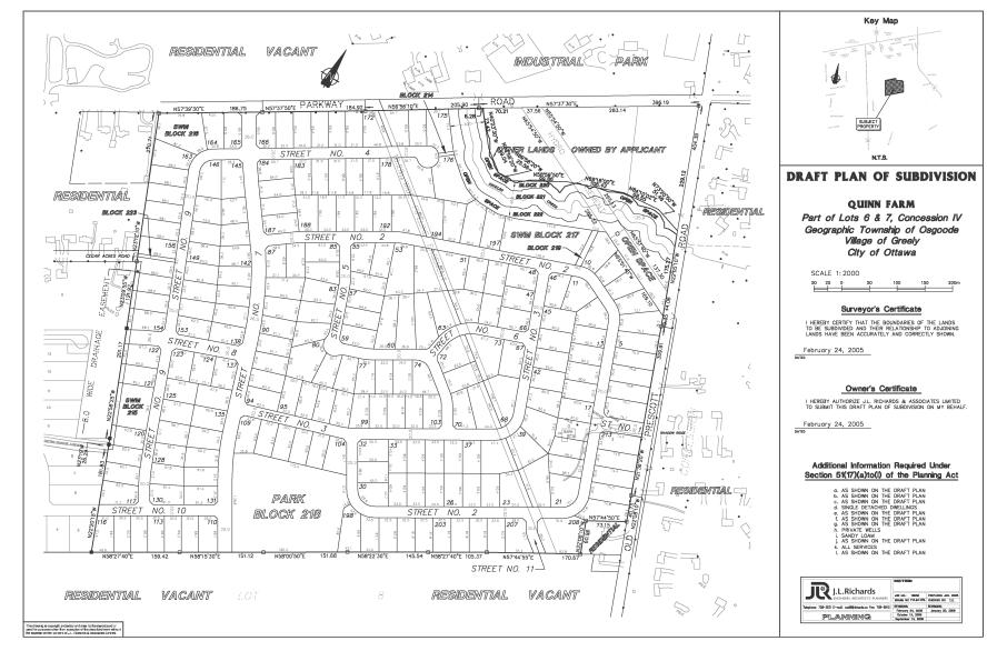
Proposed Development
The subject site is located at
1520 Old Prescott Road and is situated in the southwest quadrant of Old
Prescott Road and Parkway Road. The lands are known as “Quinn Farm” and were
most recently used for agricultural purposes. A single detached dwelling is
located in the southeast portion of the site. The parcel encompasses
approximately 76.64 hectares with approximately 576 metres of frontage along
Parkway Road and 526 metres along Old Prescott Road. To the west and east is
residential development (Stanley Park and Shadow Ridge Subdivisions,
respectively), to the north are light industrial uses (Greely Industrial Park)
and to the south is undeveloped land intended for residential uses (Cadieux
Subdivision). Andy Shields Park, a community level park, is located to the east
of the site. A portion of Shields Creek meanders through the northeast quadrant
of the site between Parkway Road and Old Prescott Road.
An existing drainage ditch is
located along the northern three quarters of the western property line. Both
Hydro One and Trans-Canada Pipeline easements encumber portions of this
property.
The proposed subdivision (refer
to Attachment 1) consists of approximately 213 lots for single detached
dwellings, 11 new streets, three blocks for storm water management ponds, one
park block, three blocks for walkways, two open space blocks and one block for
environmental protection (Shield’s Creek). Access will be provided by a
north-south collector road from Parkway Road with a second access to the
subdivision provided from Old Prescott Road. Local roads internal to the
subdivision will provide access to individual lots and individual lots will not
have direct access to either Parkway Road or Old Prescott Road. The City will
be acquiring the necessary blocks for sight triangles and reserves. The
proposed subdivision contains six phases (1 to 4, 5a and 5b), generally
developing in a westerly and southerly direction.
Phasing and Monitoring
The proposed residential
development will be serviced by wells and on-site private sewage systems and is
a pilot project to allow for development with the use of nitrate removal
technology (Waterloo Biofilter system) to treat on-site sewage. The original
Hydro-geological report could not prove sewage ‘system isolation’ from the
aquifer meaning that there is no barrier between the sewage effluent and the
water supply. Therefore the ‘dilution method’ was used to show how the
development would meet the Ministry of the Environment’s (MOE) criteria of
10mg/l of nitrate at the down gradient property line. A new approach was
considered using denitrification technology. The Hydro-geological report was
modified, peer reviewed and resulted in conditions pertaining to contingency
plans, monitoring programs and performance criteria.
The use of denitrification
technology will allow for residential development with a minimum lot area of
approximately 2000 square metres (half acre) for a total of 213 residential
units. If the denitrification technology is not used, the lot sizes must be
increased to meet the MOE criteria for dilution, thus decreasing the total
number of residential units to approximately 126. Therefore, there is a benefit
to the lot yield in proceeding on the basis of denitrification, however, there
are also risks which must be managed and mitigated.
The denitrification units as a
standard feature within a subdivision has not been used previously within the
city, therefore this subdivision is being treated as a pilot project.
Denitrification units have only been used in Ottawa for minor in-fill and
retrofit developments, rather than as a method to allow for development to
proceed with a decrease in lot size. The requirement for a monitoring program
is crucial in that it will demonstrate whether the units are performing in
accordance with the manufacturer’s specifications and MOE criteria. If the
units are not performing as per the manufacturer’s specifications, there is a
risk of not meeting the MOE dilution criteria for nitrate to10 mg/l at the
receiving aquifer. Should this occur, there is a health risk due to a potential
for elevated nitrate in the private drinking water supplies. The
denitrification system will be owned and maintained by the individual
homeowner.
City
requirements
Section 4.7 of the Ministry of
the Environment Procedure D-5-5 states: “Where a development application
relates to an additional phase of a phased development, even though previous
phases may already have been approved on the basis of previous hydrogeological
studies which encompassed those phases or the entire site, a supplementary
study and report is required” (emphasis added). Further, pursuant to
Official Plan Policy 4.4.2.1, subdivisions within Villages on private
individual services are only to be registered in phases containing a maximum of
40 lots.
The Policy also requires that
prior to the registration of subsequent phases, a servicing review study is to
be submitted to demonstrate that the continued development is appropriate
(within approval agency regulations) and to identify any additional
requirements. The City will be requiring a denitrification monitoring report to
demonstrate that the denitrification units are operating in accordance with a
prescribed criteria prior to the registration of Phases 2, 3 and 4. Doing so will
ensure that the public interest is maintained. The denitrification monitoring
report is to include the sampling of lots every four months, or three times a
year, for the first year after occupancy and then on an annual basis in order
to track the progress of the denitrification units in meeting the required MOE
criteria. The test results will be placed in the City of Ottawa Data Base.
Each lot within the subdivision
will require the installation of a Waterloo Biofilter system. Prior to the
registration of Phase 2, the denitrification monitoring report and servicing
review study will be required examining a minimum of 10 systems from Phase 1
which have been in operation for at least one full year after occupancy. The
timeline of one year after occupancy works on the premise that it takes up to
one year of operation for the denitrification unit to reach its full potential
as a nitrate treatment system, and it also captures seasonal variations.
Prior to the registration of
Phase 3, the two reports will be required studying a minimum of 40 systems
from the combined Phases 1 and 2 which have been in operation for at least one
full year after occupancy. These may include the original 10 lots from Phase 1.
Prior to the registration of
Phase 4, the two reports will be required studying a minimum of 20 systems
from Phase 3 in operation for at least one full year after occupancy. This will
result in reports for systems on a total of 60 lots out of a potential of 120
lots prior to the registration of Phase 4. Provided that favourable results are
consistently achieved, after Phase 4 (Phases 5a and 5b), the denitrification
report will not be required, however the servicing report will continue to be
required (as per MOE procedures and Official Plan policy) and is to include a
minimum of 20 private sewage systems from the preceding phase.
In normal circumstances and in
this case, a subdivision on private services would require a servicing report
with a minimum of 20 units in each phase. The City has accommodated the
proponent in this pilot project by modifying the requirement for any monitoring
reports after the third phase of development. Before registering the fourth
phase, the City will decide if the remaining development will be constructed
using the denitrification units. Favourable and consistent results will be the
governing criteria in proceeding to the next phase on denitrification units.
Phasing is to take place in
accordance with any recommendations of the denitrification monitoring report
and to the satisfaction of the City. The applicant is to provide the City with
the date of occupancy. The homeowner will be responsible for the annual
monitoring of the denitrification unit as long as it services the lot. The City
will utilize the monitoring data to assess the use and performance of
denitrification units for future developments. The estimated cost is $200 per
year for the Ottawa Septic System Office to carry out this test.
A contingency plan is required
prior to the registration of Phase 1 and subsequent phases. This plan is to
outline the remedial actions in the event the Waterloo Biofilters are not
functioning or meeting the performance/compliance criterion. It is to outline
the change in lot size in order to meet the criterion and may require an amendment
to the draft plan for the remainder of the subdivision.
Applicant’s
response
The applicant is requesting
permission to register Phase 2 one year after the registration of Phase 1 and
upon the submission of a denitrification monitoring report and servicing report
for all private sewage systems that have been built in Phase 1. Prior to the
registration of Phase 3, the two reports would be submitted studying a minimum
of 20 systems in operation for at least one full year of occupancy in Phases 1
and 2. Prior to the registration of Phase 4, the two reports would include an
additional minimum 20 systems in operation for at least one full year of
occupancy in Phases 1, 2 and 3. This results in reports for a minimum of 40
systems (number of reports from Phase 1 is dependent on the number of developed
at the end of the first year) out of a potential of 120 lots prior to the
registration of Phase 4. For each phase subsequent to Phase 4, the servicing
report would include a minimum of 20 systems in the preceding phases.
From the City’s perspective,
under this scenario, it is conceivable that no homes would be constructed
within the first year, therefore the developer will have 80 lots registered and
the City will have no monitoring results for the pilot project. The City feels
this is not an appropriate risk to take.
Sidewalks
Section 51 (25) of the Planning
Act allows the Municipality to impose conditions requiring the provisions
of pedestrian pathways within a plan of subdivision. Old Prescott and Parkway
Roads are classified as collector roads within the Official Plan. As well,
Section 4.3.11 of the Official Plan allows the City to require the provision of
sidewalks to ‘ensure that new developments are linked to the existing or
planned network of public sidewalks, recreational pathways and on-road cycle
routes’.
City
Requirement
The City has requested sidewalks
along the extents of both Old Prescott and Parkway Roads which abut the site.
The lengths are approximately 577.6 metres and 525.9 metres respectively.
Although sidewalks do not presently exist on either road, the City recognizes
the need to improve the safety of pedestrians and cyclists travelling along
either Old Prescott or Parkway Roads.
In addition and not under dispute
by the applicant, sidewalks are requested along the proposed collector roads:
along the east side of Street 7 and the south side of Street 8. In order to
provide a connection from the proposed park to Shield’s Creek, a sidewalk is
required along the southeast side of Street 3. Finally, a sidewalk along the
east side of Lot 104 is requested in order to connect the park to the sidewalk
along Street 3.
Applicant’s
Response
The applicant is of the opinion
that the intent of the Greely Village Community Design Plan (CDP) is to provide
internal linkages only and that the sidewalks requested along Old Prescott and
Parkway Roads will not link to any sidewalks of surrounding developments. They
also advise that pedestrians should not be utilizing these roads, built to
rural cross section standards, since they carry high volumes of truck traffic.
They are also of the opinion that Section 4.3.9 of the Official Plan does not
grant the authority to the City to request sidewalks where neither the roads
are new nor reconstruction is proposed.
Parkland Dedication
Sections 42(1) and 51(25) of the Planning
Act and Section 2.5.4 of the Official Plan permits the Municipality to
acquire parkland through the subdivision process at a rate of 5 per cent of the
land proposed for development. The Greely Village Community Design Plan
identifies the general location of parks and open space.
City Requirement
The City has requested the
conveyance of Block 218 as parkland dedication, as identified in the Greely
Village CDP. This block represents 4.6 per cent of the subject lands, less than
the requirement and have therefore requested that the Block either be expanded
to meet the five per cent required dedication or a payment in lieu of the
outstanding dedication be made.
Blocks 220 and 222, located 15
metres north and south of 15 metres from the normal high water mark of Shields
Creek, is required as part of the buffer area of Shields Creek as identified in
the Shield’s Creek Subwatershed Study, outlined in the Greely Village CDP and
confirmed by the South Nation Conservation Authority. These blocks should
therefore not be considered part of parkland dedication, as they are required
as constraint lands. It is understood and recognized that the City would
investigate the feasibility of constructing a pathway within this corridor.
Applicant’s
Response
The Applicant is providing Block
218 in partial fulfillment of the parkland dedication requirement. They propose
to fulfill the remainder of the dedication requirement though the conveyance of
Block 222 to the City as it will contain a pathway and, therefore, should be
considered passive recreation lands.
Conclusion
This memorandum provides
Committee with the current status of the application with respect to conditions
which are currently unresolved concerning phasing/monitoring, sidewalks and
parkland dedication.
Delegated authority was withdrawn
on October 13, 2006 by the Ward Councillor and therefore, unless delegated
authority is reinstated, the application will be brought to ARAC at a future
date with staff’s position and recommendations with respect to the draft
subdivision conditions. At that time, members of the public who had requested
further notification will receive notice of the meeting and a copy of the staff
report.
Original
signed by John L. Moser
John
L. Moser
Attachment:
Document 1, Proposed Draft Plan of Subdivision