Report to/Rapport au :
Planning and Environment Committee
Comité de l'urbanisme et de l'environnement
and/et
Agriculture and Rural Affairs Committee
Comité de l'urbanisme et de l'environnement
and Council / et au Conseil
08 September 2008 / le 08 septembre 2008
Submitted by/Soumis par : Nancy Schepers, Deputy City Manager
Directrice municipale adjointe,
Planning, Transit and the
Environment
Urbanisme, Transport en commun et
Environnement
Contact Person/Personne-ressource : Richard Kilstrom,
Manager/Gestionnaire, Community Planning and Design/Aménagement et conception
communautaire, Planning Branch/
Direction de l’urbanisme
(613)
580-2424 x22653, Richard.Kilstrom@ottawa.ca
SUBJECT:
|
COMPREHENSIVE ZONING BY-LAW 2008-250:
ANOMALIES AND minor CORRECTION - second report |
|
|
|
OBJET :
|
règlement de zonage
2008-250 : anomalies et corrections mineures – deuxiÈme rapport |
REPORT RECOMMENDATIONS
1. That
Planning and Environment Committee recommend that Council approve the
amendments recommended in Column 4 of Document 1, to correct anomalies in
Zoning By-law 2008-250; and
2.
That Agriculture and Rural Affairs
Committee recommend that Council approve the amendments recommended in Column 4
of Document 2, to correct anomalies in Zoning By-law 2008-250.
RECOMMANDATIONS DU RAPPORT
1.
Que
le Comité de l’urbanisme et de l’environnement recommande au Conseil d’approuver
les modifications recommandées dans la Colonne 4 du Document 1 afin de corriger
des anomalies dans le Règlement de zonage 2008-250;
2.
Que
le Comité de l’agriculture et des affaires rurales recommande au Conseil
d’approuver les modifications recommandées dans la Colonne 4 du Document 2 afin
de corriger des anomalies dans le Règlement de zonage 2008-250.
BACKGROUND
On June 25, 2008 City Council adopted the new Comprehensive Zoning By-law 2008-250 which affects all properties within Ottawa. By-law 2008-250 replaces the 36 Zoning By laws of the former municipalities that were amalgamated in 2001. Since the adoption of the Zoning By-law, staff have been identifying anomalies that require correction, and reports to correct the anomalies are being forwarded to Committee and Council on a regular basis. This report details recommended amendments to correct a number of the identified anomalies.
DISCUSSION
Since
the adoption of the Zoning By-law 2008-250, staff have monitored the new by-law
and have identified certain anomalies that are being recommended for
correction. Documents 1 and 2 provide staff recommendations to Planning and
Environment Committee and Agriculture and Rural Affairs Committee on the
anomalies, and include details of the recommended amendments in the urban area
in Column 4 of Document 1, and amendments to the rural or greenbelt areas in
Column 4 of Document 2. Document 3
contains the maps showing the location of zoning map corrections.
The amendments are intended to correct mapping and text reference errors in the implementation of a Council-approved changes which were not accurately reflected in the Comprehensive Zoning By-law. This report will be brought forward to the Ontario Municipal Board for approval, in conjunction with the report on Ontario Municipal Board appeals (ACS2008‑PTE‑PLA-0196).
CONSULTATION
Notice of the public meeting to deal with these anomalies and corrections was provided in The Citizen and Le Droit, with a listing of the addresses and provisions subject to correction. As well, interested parties have been notified by individual mail.
FINANCIAL IMPLICATIONS
SUPPORTING DOCUMENTATION
Document
1 List of Anomalies and Modifications
to Zoning By-law 2008-250 for consideration by Planning and Environment
Committee
Document 2 List of Anomalies and Modifications to Zoning By-law 2008-250 for consideration by Agriculture and Rural Affairs Committee
Document 3 Location Maps
DISPOSITION
Planning, Transit and the Environment Department to prepare the implementing by-law, forward it to Legal Services Branch who will then forward the report and by-law to the Ontario Municipal Board for approval.
LIST OF ANOMALIES AND MODIFICATIONS
TO ZONING BY-LAW 2008-250 FOR CONSIDERATION
|
Item No. |
Reference |
Objective of
Amendment |
Proposed Amendment |
|
1 |
|
The zoning map incorrectly places the site in the Exception [502] rather than the correct Exception [1502] |
Revise the Zoning Map as it affects 17 Myrand Avenue by rezoning the site to LC[1502] as shown on Document 3. |
|
2 |
Part 5, Section 122(3 ) - Conversions |
The inclusion of group home in the list of uses that must be serviced with public services, other than in large-lot Rural Zones or higher density rural residential, is an anomaly, as the use should be permitted wherever dwellings are permitted according to the Official Plan. There is no proviso that a group home created through conversion must only occur on public services. |
Revise Section 122 (3) to delete the term “group home”, where it occurs in the first line of Subsection 122 (3). |
|
3 |
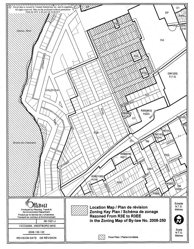
Westboro Beach, east of Churchill Avenue North south of the Ottawa River Parkway and west to Beechgrove and Ferndale Roads. |
Implement Council Motion No. 35/14 to lower the height limit of portions of R3E zoned areas in Westboro Beach from 11 metres to 8 metres; a larger geographical area than what was intended by the motion erroneously got covered under the lowered height limit and should continue to be zoned to permit a maximum of 11 metres. The 8 metre height limit should not apply to the R3E zoned lands located to the east of Churchill Avenue North south of the Ottawa River Parkway and west to Beechgrove and Ferndale Roads. |
1. Create a new subzone R3EE in Table 160A, immediately below the R3E subzone, and
repeat all provisions required in the R3E subzone save and except, for the
"Maximum Building Height (m)" in Column VI, in which case the
maximum height for a principal building will be shown as "11",
meaning 11 metres. 2. Apply the subzone R3EE to the zoning map, particularly to the portion of Westboro Beach currently zoned R3E, located to the east of Churchill Avenue North, generally north of Bloomfield,the west side of Beechgrove and Ferndale Roads, and south of the area zoned O1L[310]-h and the Ottawa River Parkway as shown on Document 3. |
|
4 |
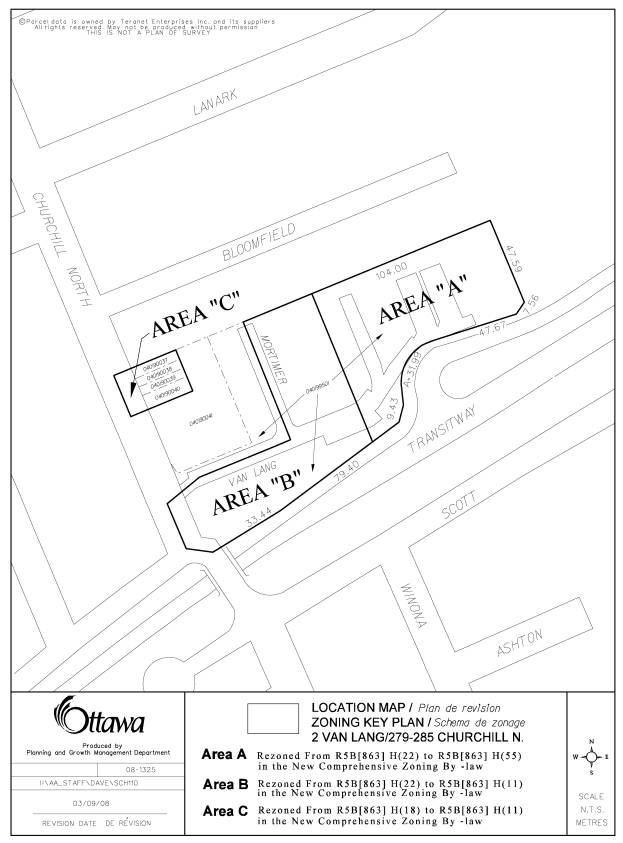
279-285 Churchill Avenue N. and 2 Van Lang Private |
The permitted height of these lands zoned now zoned
R5B[863]H(18) and R5B[863]H(22) was covered under Schedule 110 in the former
Ottawa Zoning By-law. The new Zoning By-law eliminated schedules relating to
height where possible because it was now possible to geo-reference areas
right on the zoning map. However, in transfering the height limits onto the
zoning map, a number of errors were made to the heights shown on the map and
should be corrected consistently with the heights as they applied under
former City of Ottawa Schedule 110. |
1. Amend the zoning map for 279-285 Churchill Avenue North
from H(18) to H(11) as shown as Area C on Document 3. 2. Amend the zoning map for 2 Van Lang Private such that
the westerley portion changes the permitted height from H(22) to H(11) as
shown as Area B on Document 3, and the easterley portion from H(22) to H(55)
as shown as Area A on Document 3. 3. Modify Column II in exception [863] to delete reference
to R5B[863]H(22) and replace with R5B[863]H(11) and R5B[863]H(55). |
|
5 |
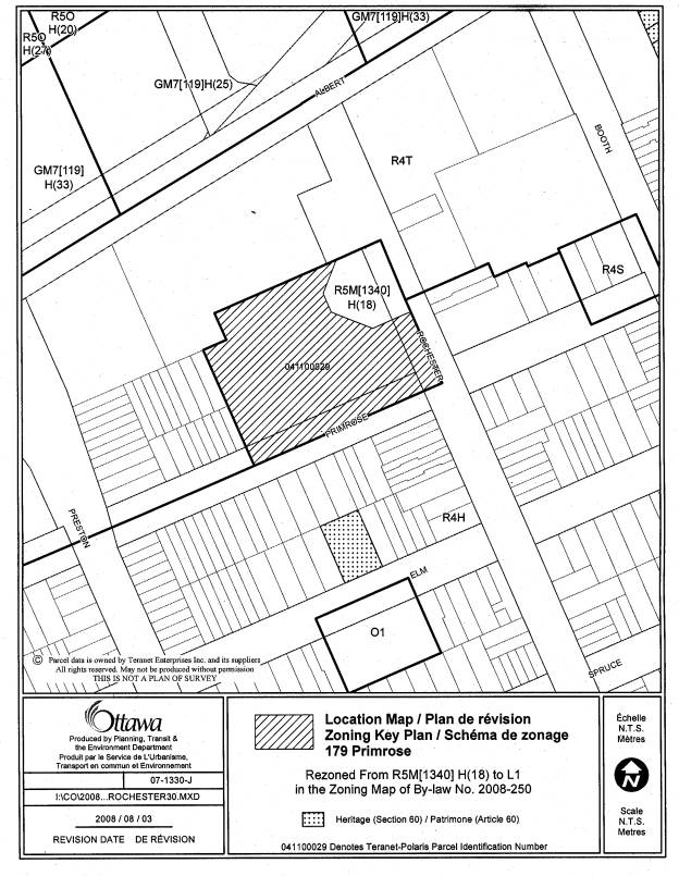
179 Primrose Avenue |
The R5M[1340]II(18) was erroneously applied to 179 Primrose Avenue. The property should be zoned L1 to carry forward the Leisure zoning, under former Ottawa Zoning By-law 93-98. |
Change the zoning map to indicate that the affected lands should be zoned L1 as shown on Document 3. |
|
6 |
Exception 1340 (multiple sites) |
Exception 1340 – this exception must be amended to continue to reflect the appropriate paragraph, which in earlier drafts was (c), but through modifications, has now become (d), in which the minimum separation distance of 300 m is required. |
Amend Part 15 – Exception [1340] to state that “Section 125 (d) does not apply” |
|
7 |
Section 124 – Garden Suites |
Section 124 (2) (a) restricts garden suites to one per lot, with said clause not precluding each half of a semi-detached from having one, regardless of whether they have been severed. However, the Table 124 (1) repeats the requirement of one per lot, without excluding semi-detached. The Table does not reflect properly those regulations of Subsections 124(2) and (3). Therefore remove row (1) of Table 124. |
Amend Table 124 to delete row (1) - the maximum number of garden suites per lot, and renumber all subsequent rows. |
|
8 |
Part 5, Sections 127 and 128 - Home Based Businesses Paragraph 127(1) (f) |
Paragraph 127(1) (f) is referred to in Subsection 128 (7), but paragraph (f) does not exist. During a revision to Section 127 (1), paragraph (a) was considered redundant and was deleted, which should have resulted in both the re-lettering of the subsection, as well as in any references to Section 127(1). Clause 128(7) was not revised to refer to the re-lettered paragraph (e). |
Amend Subsection 128(7) by changing the reference to paragraph 127(1) (f) to 127(1) (e). |
|
9 |
Part 2, Section 65 and Table 65 – Permitted Projections |
Former City of Ottawa had a provision allowing carports to project usually into the interior side yard where there was limited space available. This provision should have been carried over to deal with many existing carports which would become non-complying. |
1. Modify subsection 65(a), to add the words “, except as set out in (9)” of Table 65. 2. Add subsection (9) as follows: For a residential use building, a carport that cannot be built in conformity with the regulations governing an accessory-use building, it may still be built if, (a) it is attached to the house to which it is accessory; (b) it is entirely open on at least two sides; (c) it is built over the driveway; (d) it is not in, (i) a required front yard, (ii) a required side yard abutting a street, or (iii) that area of the rear yard abutting a street that is equal distance from the side lot line abutting the street as the required corner side yard. |
|
10 |
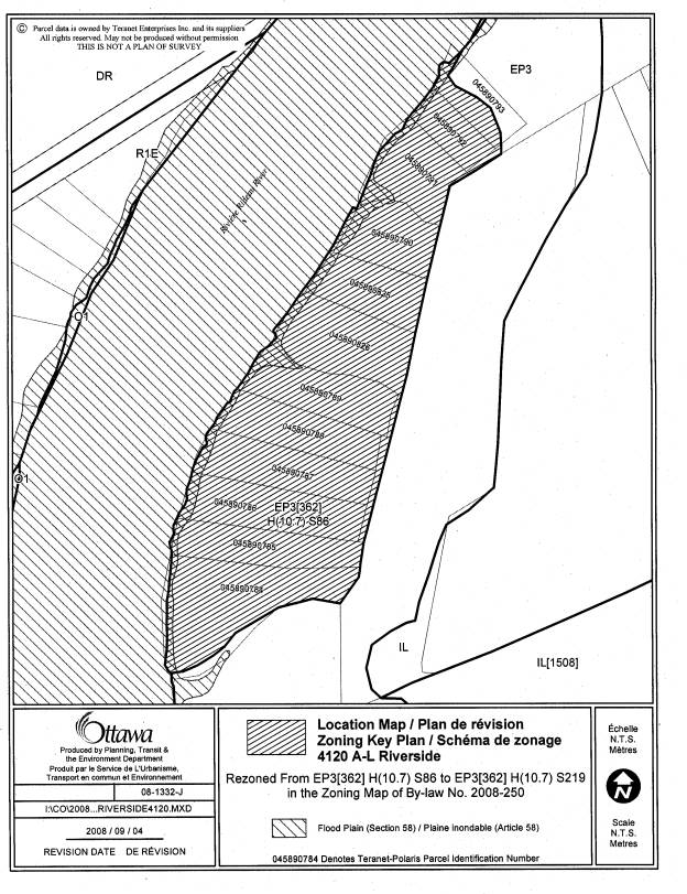
4120 A-L Riverside Drive |
Schedule reference 86 is incorrect. The correct Schedule is 219 |
Amend the zoning map to replace the schedule reference S86 with S219 at 4120 A-L Riverside Drive as shown on Document 3. |
|
11 |
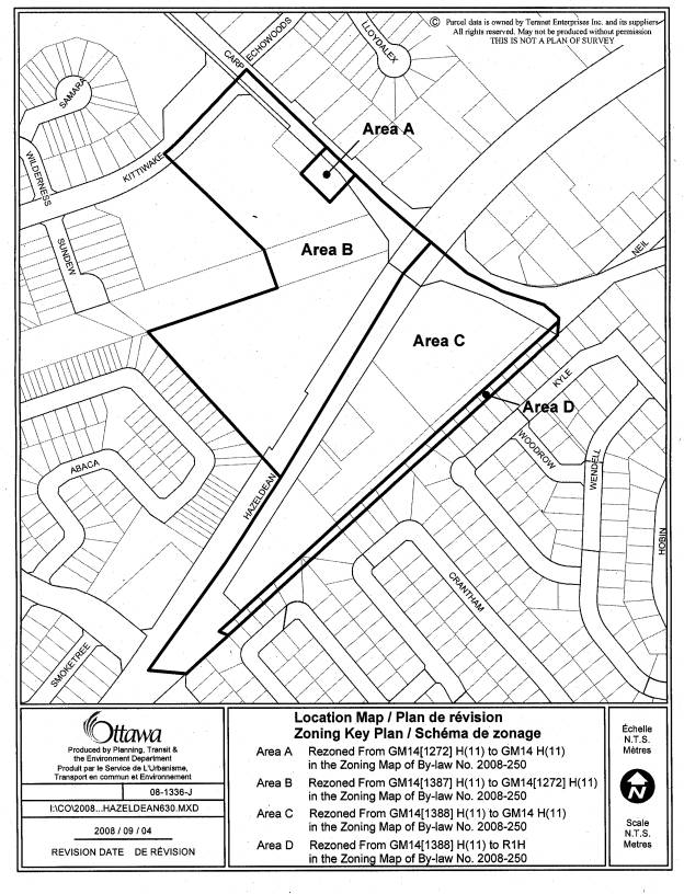
Area along Carp Road and Hazeldean Road in Stittsville – GM14 subzone and exception zones and including lands at rear of lots of Heritage Grove Crescent, Cratham Crescent and Kyle Avenue zoned GM14 subzone |
There are a number of errors in the mapping of the zoning for this area such that the new zoning does not reflect the intent of the existing zoning in the former Goulbourn Zoning By-law, and changes that were not properly implemented following public submissions and internal comments on the new Zoning By-law or due to the lack of geo-referencing in former municipality zoning maps as follows: 1.Former Goulbourn CH zone had a limit of 35,000 m2 per lot. In response to a submission, it was agreed that this limit, instead of the 2.0 floor space index should apply to the corresponding GM14 subzone in the new Zoning By-law. This provision was applied as an exception zone [1388], and should have applied to the GM14 zone. 2. The rear of the detached dwelling lots abutting the GM14[1388] H(11) zone along Hazeldean Road are also zoned GM14[1388]H(11) and instead should be zoned R1H, similar to the rest of each lot. The new Zoning By-law carried forward the zoning line in the former Goulbourn Zoning By-law, which was imprecise. 3.Former CH-6 zone provisions of Goulbourn that apply to the property at 6303 Hazeldean, and 1122 Carp Road, were erroneously applied to 1130 Carp Road. |
1.Amend the zoning map to eliminate exception [1388] for land south of Hazeldean Road, between West Ridge Road and Carp Road as shown as Area C on Document 3 and instead insert the provisions of exception [1388] into the GM14 subzone provisions. 2. Amend the zoning map to change the zoning from GM14[1388]H(11) to R1H for the rear of those properties as shown as Area D on Document 3. 3.Amend the zoning map to replace exception [1387] with exception [1272] on 1122 Carp Road and 6303 Hazeldean Road, as shown as Area B on Document 3 and delete exception [1387] provisions from the exception table. 4. Amend the zoning map to change the zoning of 1130 Carp Road from GM14[1272]H(11) to GM14 H(11) as shown as Area A on Document 3. |
|
12 |
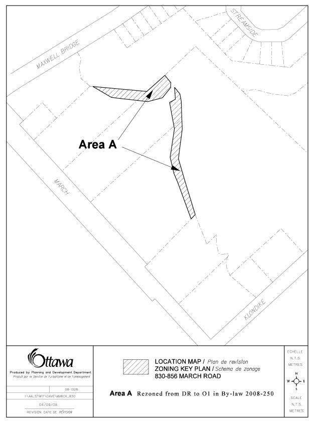
Part of 830-856 March Road – Shirley’s Brook |
The watercourse at the rear of these properties was zoned OS1 in the former Kanata Zoning By-law and was intended to be open space, but was erroneously zoned DR, a development reserve zone similar to the adjoining lands to the east. |
Amend the zoning map to rezone the lands to the O1, Open Space zone as shown on Document 3. |
|
13 |
South of Strandherd, between Haydon Circle and Madrid Avenue - R3Z[1319] S233 zone |
The wording in the exception does not exactly carry forward the intent of the existing wording in the former City of Nepean Zoning By-law with respect to permitted projections into the front and interior side lot lines. |
Change wording in Exception 1319 from “may project up to 1 m” to “are permitted no closer than 1 m”. |
|
14 |
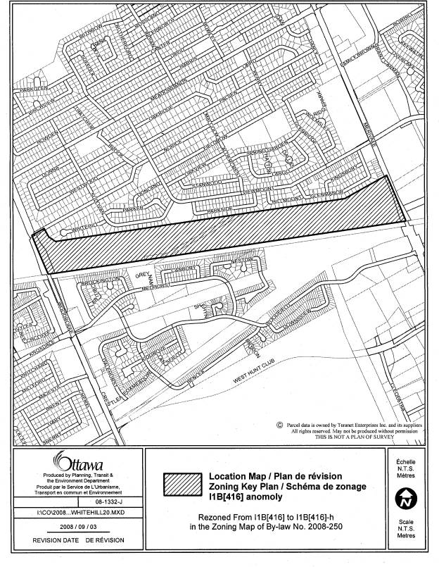
Lands north of railway tracks between Woodroffe Avenue and Merivale Road |
The lands are an institutional zone and under former Nepean Zoning By-law, had a holding symbol. While the new Zoning By-law contains the holding provisions in the I1B[416] exception provisions, the zoning designation should have a “h” symbol attached. |
1. Amend the zoning map to show a I1B[416]-h as shown on Document 3. 2. Correct the zoning designation in Column II, applicable zone for exception [416] to an I1B[416]-h |
|
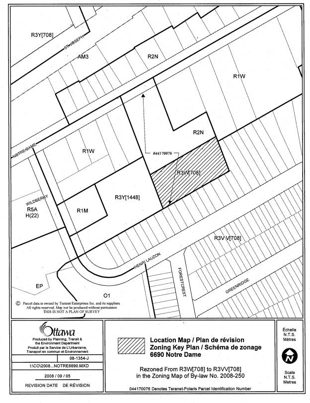
15 |
6690 Notre Dame Street |
The letters “V V” were misread to be one letter “W” in the case of this property. The amendment will revise the map to zone the property R3V V[708] |
Amend the zoning map to rezone the lands identified on the location map as Area A to R3V V[708] as shown on Document 3. |
LIST OF ANOMALIES AND MODIFICATIONS
TO ZONING BY-LAW 2008-250 FOR CONSIDERATION
|
Item No. |
Reference |
Objective of
Amendment |
Proposed Amendment |
|
1 |
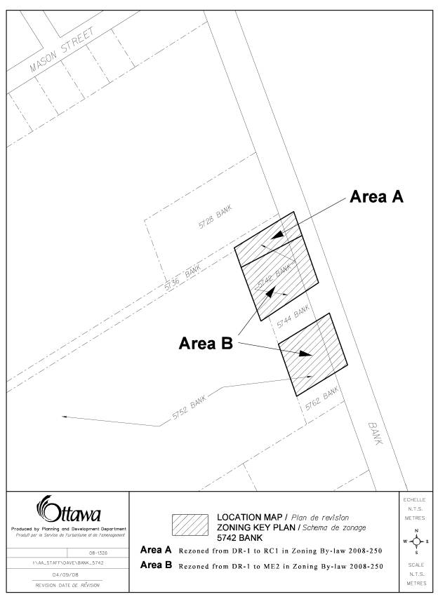
5742 Bank Street |
The zoning mapping in former Osgoode Township was often
not accurate in terms of following property lines. This property known as
5742 Bank Street was zoned C2, a
highway commercial zone for the north one third of the property, and a
ME1[1] mineral extraction zone for the balance of the property. The property has been zoned DR,
development reserve and should instead revert back to the split zoning on the
property. |
For 5742 Bank Street, amend the zoning map to rezone the
north third of the property to an RC1 zone to match the former Osgoode zoning
map, and amend the zoning map to place the ME2 on the balance of the property
as shown on Document 3. |
|
2 |
5752 Bank |
The frontage on Bank Street of this large property was zoned
DR, development reserve, when it should have retained the mineral extraction
zoning for the rest of the property. |
Amend the zoning map to rezone the Bank Street frontage of
the property to ME2 as shown on Document 3. |
|
3 |
1725 Dunrobin Road |
The zoning map correctly identifies the site-specific
zoning as RC1[465r], but the 1 was omitted from Column II of the Exception |
Modify Part 15, Rural Exception [465r] by correcting the
reference in Column II as RC1 [465r] |
|
4 |
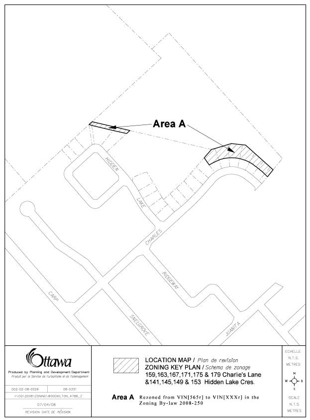
159, 163, 167, 171, 175, and 179 Charlie's Lane, 141, 145, 149, and 153 Hidden Lake Crescent and Block 59 on Plan 4M-1184 in Village of Carp |
Under the former West Carleton Zoning By-law, the rear of these properties was zoned an open space zone permitting only conservation use, however the area could be used for the calculation of minimum lot area and setbacks. In the new Zoning By-law, this restriction is not identified and needs to be corrected to properly reflect the intent of the zoning for the lands. |
1. Change the zoning maps so that a new V1N exception zone is created for the part of the properties zoned OS8 in the former West Carleton Zoning By-law as shown on Document 3. 2. The new exception with contain the following provisions: - in Column IV of the exception provisions, all uses will be prohibited - in Column V, the following provisions will be inserted: “Buildings and structures of any kind are prohibited including but not limited to: a deck, gazebo, shed, garage, workshop, septic system, well, swimming pool, change house, pump house, stairs and any structural landscaping” and “the lands may be used for the calculation of minimum lot area and setback provisions for the adjoining V1N[565r] zone” |
Site-specific Lands Affected Maps DOCUMENT
3
|
Location Maps (attached) |
|
17 Myrand Avenue |
|
Westboro Beach |
|
279-285 Churchill Avenue North and 2 Van Lang Private |
|
179 Primrose |
|
4120 A-L Riverside Drive |
|
Intersection of Carp and Hazeldean Roads, Stittsville |
|
Part of 830-856 March Road |
|
Lands north of railway tracks between Woodroffe Avenue and Merivale Road |
|
6690 Notre Dame Street |
|
5742 and 5752 Bank Street |
|
141, 145, 149, and 153 Hidden Lake Crescent Block 59 on Plan 4M-1184 |
17 Myrand Avenue

Westboro Beach
279-285 Churchill Avenue North and 2 Van Lang Private
179 Primrose Avenue
4120 A-L Riverside Drive
Intersection of Carp and Hazeldean Roads, Stittsville
Part of 830-856 March Road
Lands north of railway tracks between Woodroffe Avenue
and Merivale Road
6690 Notre Dame Street
5742 and 5752 Bank Street
159, 163, 167, 171, 175 and 179 Charlie’s Lane,
141, 145, 149 and 153 Hidden Lake Crescent, Block 59 on
Plan 4M-1184