Report to/Rapport au :
Agriculture and Rural Affairs Committee
Comité d'agriculture et des questions rurales
and Council / et au Conseil
29 January 2008 / le 29 janvier 2008
Submitted by/Soumis par : Nancy Schepers, Deputy City Manager /
Directrice municipale adjointe,
Planning, Transit and the Environment / Urbanisme,
Transport en commun et Environnement
Contact Person/Personne ressource : Karen Currie,
Manager / Gestionnaire, Development Approvals / Approbation des demandes
d'aménagement
(613) 580-2424, 28310 Karen.Currie@ottawa.ca
|
SUBJECT: |
ZONING - 2870 Rideau Road and 5055
Albion Road (File #D02-02-07-0034) |
|
|
|
|
OBJET : |
REPORT RECOMMENDATION
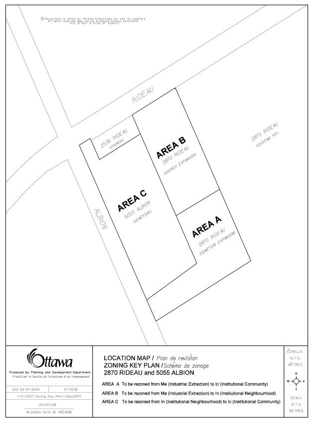
That the recommend Council approve an amendment to the former City of Gloucester Zoning By-law to change the zoning of 5055 Albion Road and a part of 2870 Rideau Road from Institutional Neighbourhood Zone (In) and Industrial Extraction Zone (Me) to Institutional Community Zone (Ic) and Institutional Neighbourhood Zone (In), as shown in Document 1.
RECOMMANDATION DU RAPPORT
Que le Comité de l’agriculture et des affaires
rurales recommande au Conseil d’approuver une modification au Règlement de
zonage de l’ancienne Ville de Gloucester afin de changer la désignation de
zonage du 5055, chemin Albion et d’une partie du 2870, chemin Rideau de Zone de
quartier institutionnelle (In) et de Zone d’extraction industrielle (Me) à Zone
communautaire institutionnelle (Ic) et à Zone de quartier institutionnelle
(In), tel qu’il est indiqué dans le document 1.
BACKGROUND
The subject properties are located southeast of the intersection of Albion Road and Rideau Road. A cemetery currently occupies the property at 5055 Albion Road. An active pit operates from 2870 Rideau Road, although the part of this property intended to be rezoned was exhausted many years ago and is densely treed. These lands contain a berm and are traversed by a hydro corridor.
Immediately north of the subject lands is the South Gloucester United Church located at 2536 Rideau Road. Agricultural uses and the Rideau Carleton Raceway are located north of Rideau Road. Residential uses and the future site of the Central Canada Exhibition can be found northwest of the subject lands. Active sand pits exist to the south and east.
This Zoning By-law amendment application has been made to fulfill a severance condition relating to two lot line adjustments. The owners of 2870 Rideau Road would like to convey the vacant parcels to the South Gloucester United Church and the Johnston’s Corners Cemetery Association. As part of this Zoning By-law amendment, the landowners are also seeking to regularize the legal non-conforming use, a cemetery, at 5055 Albion Road.
Purpose of
Zoning Amendment
South Gloucester United Church and Johnston’s Corners Cemetery Association are seeking to consolidate parts of 2870 Rideau Road with 2536 Rideau Road (South Gloucester United Church) and 5055 Albion Road (Johnston’s Corners Cemetery Association) to extend the church use and cemetery use, respectively.
According
to the Gloucester Zoning By-law, 5055 Albion Road is presently zoned
“Institutional Neighbourhood Zone (In)” and 2870 Rideau Road is zoned
“Industrial Extraction Zone (Me)”. The
permitted uses within an Institutional Neighbourhood Zone are a day nursery,
school, place of worship, and private school.
The permitted uses for an Industrial Extraction Zone (Me) are quarry,
sand or gravel pit, agriculture, and forestry.
Areas A and C, as shown in Document 1, will be rezoned to “Institutional Community Zone (Ic)” to regularize the existing cemetery use and allow for its future expansion. Through the lot line adjustment, Area A will be severed from the pit operation and merged with the cemetery lands. Area B, in Document 1, will be rezoned to “Institutional Neighbourhood Zone (In)” to permit the expansion of the place of worship found on the adjacent property immediately west. These lands will also be merged in title.
DISCUSSION
The Official Plan designates the lands being considered for rezoning as “Sand and Gravel Resource Area”. The designation protects non-renewable mineral aggregate resources which are located close to markets for future use, and from incompatible activities. This designation is also intended to protect areas of natural resource production from loss to other uses. It further ensures that sensitive uses, such as residential developments that would result in conflicts with natural resource operations, are not to be established within proximity of the resource areas. Where the sand, gravel or limestone aggregate resources of a property have been fully extracted, the property may be used for other purposes. Similarly, if a technical study demonstrates that the aggregate resources of a site are not suitable for exploitation, then alternative land uses may be permitted. Under either scenario, the City requires that:
a) The proposed use will not limit the possibility of mineral aggregate extraction from other lands designated Sand and Gravel Resource Area; and,
b) Any issues of public health, public safety and environmental impact are addressed.
In Sand and Gravel Resource Areas that are depleted or not suitable for exploitation, the property may be used for purposes listed under the Agriculture Resource or additional new uses as follows:
a) If the lands are predominately surrounded by an Agriculture Resource designation, the uses identified in Agriculture Resource Areas may be permitted. Where a pit license has been surrendered and the pit was located on prime agricultural lands, the site will be rehabilitated for productive agricultural use except where extraction has occurred below the water table; or if the lands are predominantly surrounded by designations other than Agriculture Resource, the uses for the General Rural Area, including farming, may be permitted.
The proposed uses conform with these policy objectives. The surrounding lands are designated General Rural Area. Churches and cemeteries are permitted within such designations.
Technical issues related to environmental, noise, traffic and servicing concerns will be dealt with through conditions of severance and at time of site plan control. A Mineral Aggregate Site Assessment was submitted to determine the aggregate resource potential. The site is part of the buffer area between the existing church, cemetery, and active sand pit. The study concluded that the westerly portions of the site had been previously stripped as part of the prior extraction operation on the site.
Staff supports the proposed
zoning as it will regularize a legal non-conforming situation and bring the
lands to be conveyed into the same zoning.
ENVIRONMENTAL IMPLICATIONS
N/A
RURAL IMPLICATIONS
The approval of this application will enable the expansion of a church and cemetery, both of which serve the rural area.
CONSULTATION
Notice of this application was carried out in accordance with the City's Public Notification and Consultation Policy. The Ward Councillor is aware of this application and the staff recommendation. The City did not receive any negative comments or opposition to this application.
FINANCIAL IMPLICATIONS
APPLICATION PROCESS
TIMELINE STATUS
The application was not processed by the "On
Time Decision Date" established for the processing of Zoning By-law
amendments due to the complexity of the issues associated with Sand and Gravel
Resource designation.
SUPPORTING DOCUMENTATION
Document 1 Location Map
DISPOSITION
City
Clerk’s Branch, Council and Committee Services to notify the Owners: South
Gloucester United Church, 2536 Rideau Road, Ottawa, ON, K1X 1A1;
Johnston’s Corners Cemetery Association c/o. Diane Wright, Secretary-Treasurer,
1215 County Road #1, Rural Route 2, Mountain, ON, K0E 1S0; Applicants: Donald R. Good, 43
Roydon Place, Suite 207, Ottawa, ON
K2E 1A3; Michael Wright, Wright Consulting Services, 233 Ave des Paysans, Gatineau, QC
J9J 2J7 OttawaScene.com,
174 Colonnade Road, Unit #33, Ottawa, ON
K2E 7J5,
Ghislain Lamarche, Program Manager, Assessment, Financial Services Branch (Mail
Code: 26-76) of City Council’s
decision.
Planning,
Transit and the Environment Department to prepare the implementing by-law,
forward to Legal Services Branch and undertake the statutory notification.
Legal Services Branch to forward the
implementing by-law to City Council.
LOCATION MAP DOCUMENT
1