Report
to/Rapport au :
Rural and Agricultural Affairs
Committee
30 January
2008 / le 30 janvier 2008
Submitted by/Soumis par Nancy Schepers, Deputy City Manager/Directrice
municipale adjointe
Planning,
Transit and the Environment/ Urbanisme, Transport en commun et Environnement
Contact
Person/Personne Ressource : Grant Lindsay, Manager / Gestionnaire,
Development Approvals / Approbation des demandes d'aménagement
(613)
580-2424, 13242 Grant.Lindsay@ottawa.ca
|
SUBJECT: |
OFFICIAL PLAN and Zoning - 2436 CARP
ROAD (FILE NOs. D01-01-06-0008, d02-02-06-0062) |
|
|
|
|
OBJET : |
REPORT
RECOMMENDATIONS
That the Agricultural and
Rural Affairs Committee recommend Council:
1. Approve and adopt an amendment to the
Official Plan for the City of Ottawa to redesignate the property situated at
2436 Carp Road from Limestone Resource Area to Carp Road Corridor Rural
Employment Area as detailed in Document 2;
2. Approve a revision to the Carp Road Corridor Community Design Plan to amend the land use designation of 2436 Carp Road from Limestone Resource Area to Heavy Industrial Area, in accordance with the above-noted Official Plan amendment; and
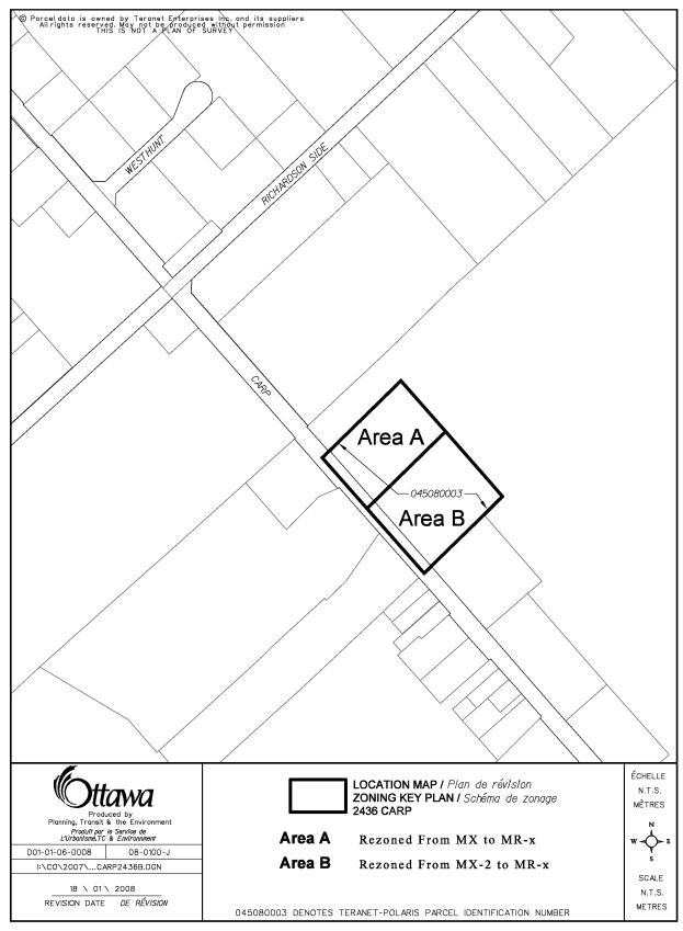
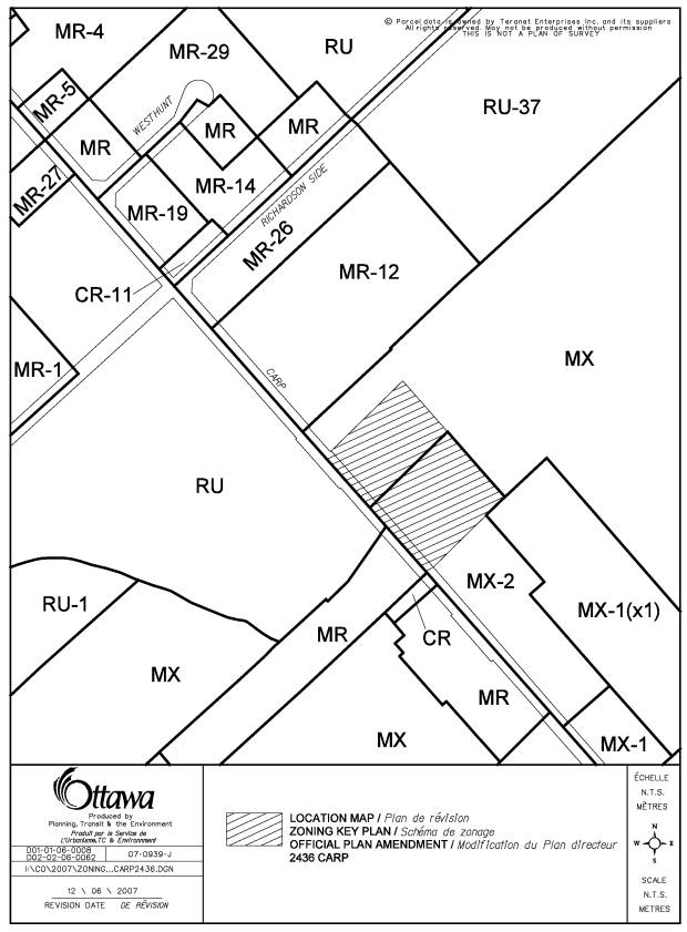
3. Approve an amendment to the former Township of West Carleton Zoning By-law, to change the zoning of 2436 Carp Road from Extractive Industrial Zone (MX) and Extractive Industrial Zone, Exception 2, Concrete and Cement, (MX-2) to Rural Industrial Zone- exception (MR-31), as shown in Document 1 and detailed in Document 3.
RECOMMANDATIONS DU RAPPORT
Que le Comité de l’agriculture et
des affaires rurales recommande au Conseil d’approuver ce qui suit:
1.
Approuver et adopter une modification au Plan officiel de la Ville
d'Ottawa, afin de modifier la désignation de la propriété située au 2436,
chemin Carp, qui passerait de Secteur de ressources de calcaire à Secteur
d'emploi rural du couloir du chemin, tel qu'exposé en détail dans le Document 2;
2.
Approuver une révision au plan de conception communautaire du couloir du
chemin Carp, de manière à modifier la désignation d’utilisation du sol du 2436, chemin Carp, qui passerait de
Secteur de ressources de calcaire à Secteur d’industrie lourde, conformément à la modification du Plan
officiel susmentionnée;
3.
Approuver
une modification au Règlement de zonage de l’ancien canton de West Carleton, de
manière à faire passer le zonage du 2436, chemin Carp de Zone industrielle
d’extraction (MX) et Zone industrielle d’extraction, exception 2, Béton et
ciment, (MX-2) à Zone industrielle rurale - exception (MR-31), tel qu’illustré
dans le Document 1 et exposé en détail dans le Document 3.
BACKGROUND
The
subject site is located at 2436 Carp Road, on the east side of Carp Road
between Highway 417 and Richardson Side Road. The subject site has 76 metres of frontage along Carp
Road and is four hectares in area. The site is currently vacant.
The lands to the east and south of the subject
site are occupied by the Spratt Quarry, licensed under the Aggregate Resources
Act. The land uses along Carp Road include the quarry operation as well as a
number of aggregate-based industrial businesses which take advantage of their
proximity to the aggregate operation at the Spratt Quarry. Various other commercial/industrial uses on
Carp Road in the vicinity of the subject site include a landscaping business,
kitchen manufacturer, garden shed sales business, and the Carp Road Landfill
site. Residential and rural uses are present on the west side of Carp Road,
close to the subject property.
The property is located within an
area designated "Limestone Resource Area" in the Official Plan. The
designation affects an area between Carp Road and Oak Creek Road, from
Highway 417 to the northerly limit of the subject property. The
designation reflects the existence of the Spratt Quarry on the adjacent lands.
This designation is intended to protect non-renewable aggregate resources for
future use, to protect the resource from incompatible activities and to
minimize community and environmental disruptions from aggregate extraction
activities.
Zoning
By-law Amendment
The northern half of the property is currently
zoned Extractive Industrial Zone (MX), which permits a gravel pit, a stone
quarry, an open storage area and
accessory administrative buildings. The southern half of the property is
zoned Extractive Industrial Zone, Exception 2, Concrete or Cement ( MX-2). The
exception specifies that the lands shall only be used for concrete batching or
cement manufacturing.
Requested Official Plan and Zoning By-law Amendments
The purpose of this Official Plan
amendment application is to redesignate the subject property from
"Limestone Resource Area" to "Carp Road Corridor Rural
Employment Area". This designation affects most of the lands along Carp
Road within a nine-kilometre corridor between Highway 417 and the Village of
Carp. The Carp Road Corridor Rural Employment Area is designated with
the intent to reserve the land for rural industrial and commercial uses, and was to provide the opportunity to
attract industries requiring large amounts of land and the openness of a rural
site.
The Zoning By-law amendment proposes to rezone
the site from the current Extractive Industrial Zone (MX) and Extractive
Industrial Exception Zone, Concrete and Cement (MX-2), to Rural Industrial
Exception Zone (MR-x). The permitted uses in this zone would include an
assembly plant, manufacturing and other heavy industrial uses.
DISCUSSION
Provincial Policy Statement
The Provincial Policy Statement states that mineral aggregate resources are to be protected for long-term use. Section 2.5.2.4 of the Provincial Policy Statement states the following:
“Mineral aggregate operations shall be protected from development and activities that would preclude or hinder their expansion or continued use.”
Section 2.5.2.5 of the Provincial Policy Statement states the following:
“In areas adjacent to or in known deposits of mineral aggregate resources, development and activities which would preclude or hinder the establishment of new operations or access to resources shall only be permitted if:
a) Resource use would not be feasible; or
b) The proposed land use or development serves a greater long-term public interest; and
c) Issues of public health, public safety and environmental impact are addressed.”
No technical report was prepared to provide details on the quality or quantity of aggregate resource available on the subject lands. Notwithstanding the presence of a known aggregate on the subject property, quarry development on the subject property is not feasible for several reasons:
· The volume of material available from the site would be extremely limited due to the small size of the property.
· Removal of material from this property would require the establishment of a licensed quarry or expansion of the existing licensed Spratt Quarry. Extensive analysis of environmental matters in accordance with the Aggregate Resources Act would be required, including an evaluation of noise, dust, vibration, traffic volumes as well as hydrogeological, cultural and natural environment assessments. The effort and expense involved in preparation of these technical reports cannot be justified, and the required public process for establishing a four-hectare quarry on this site would face strong opposition. The small land area, combined with the required setbacks for buffering, suggest that quarry development on the subject lands would not be feasible. It is therefore unlikely that a quarry license for this property could ever be issued for this property.
· The operational plan of Spratt Aggregates for the abutting property is to continue to move eastward away from Carp Road. Technical reports prepared in support of the existing operation indicate that the licensed area and future extraction limits contain a supply of material for at least 50 years.
For the above-noted reasons, any existing resource located on the subject property does not merit the protection because it is not feasible to establish a quarry on the property.
Section 3.7.4 of the Official Plan, “Mineral Resources” contains policies applicable to lands identified as “Sand and Gravel Resource Area” or “Limestone Resource Area”, and containing deposits of aggregates. Existing licensed extraction sites make up much of the future supply of aggregate, and the policies are in place to ensure the City will protect their continued operation and expansion by preventing new development in their vicinity that would preclude or hinder aggregate extraction.
The property is designated
"Limestone Resource Area" in the Official Plan. The policies of
Section 3.7.4.1 supporting this designation are intended to:
a) Protect
mineral aggregate resources, located close to markets, for future use;
b) Protect
mineral aggregate resource and aggregate operations from incompatible
activities;
c) Minimize
community and environmental disruptions from aggregate extraction activities.
The possibility of a quarry being established on the site is unlikely. The small land area, combined with the required setbacks for buffering, suggest that quarry development on the subject lands would not be feasible, and it is therefore unlikely that a quarry license for this property would ever be issued for this property. For the above-noted reasons, any existing resource located on the subject property does not merit the protection provided by the “Limestone Resource Area” designation because it is not feasible to establish a quarry on the property.
Section 3.7.4.10 of the Official Plan states:
“Limited types of new development may be approved within 500 metres of a Limestone Resource Area provided such development does not conflict with future mineral aggregate extraction. Examples of conflicting land uses include dwellings or lodging places, farming or small-scale business uses where animals, equipment or employees are affected by pit or quarry activities.”
The subject site is located immediately adjacent
to the Spratt Quarry lands that are currently licensed by the Ministry of
Natural Resources. New development on the affected lands must demonstrate that
the mineral aggregate operation will not be affected by the development.
Numerous other properties in the immediate area that lie within the 500-metre
sphere of influence of the Spratt Quarry are designated “Carp Road Corridor
Rural Employment Area”. Development of these properties must address
compatibility through appropriate site planning and impact mitigation. The
redesignating of the subject site and application of site planning principles
would be consistent with the approval process required for the other properties
within 500 metres of the quarry. The removal of the Limestone Resource Area
designation from the subject lands will promote development in accordance with
the Carp Road Corridor Rural Employment Area, and would be consistent with
other industrial uses along the Carp Road corridor.
Section 3.7.4.16 of the Official Plan states:
“In Limestone Resource Areas that are depleted
or not suitable for exploitation, the property may be used for purposes listed
in Section 3.7.3. Other new uses, except residential, are permitted, subject to
Section 3.7.2. A rezoning to an appropriate use will require that:
a)
The
proposed use will not limit the possibility of mineral extraction from other
lands designated Sand and Gravel resource Area or Limestone Resource Area, and
b)
Issues
of public health, public safety and environmental impact are addressed
to the satisfaction of the City.”
As noted
above in the discussion of the applicable provincial Policy Statement, the
subject property is not suitable for resource exploitation. Rezoning of the
subject property for other purposes is appropriate for the following reasons:
·
The
subject property can be developed in accordance with the Carp Road Corridor
Rural Employment Area designation. This effectively creates a buffer between
the Carp Road properties and the licensed area of the quarry, prohibiting
expansion of the quarry towards the west, and will achieve compatibility between
the adjoining properties.
·
The
vision for the Carp Road Corridor is to provide employment opportunities
through a full range of industry sectors, including manufacturing, retail,
construction, as well as professional and business services. The proposed Rural
Industrial Zone would limit the range of uses to those of a heavy industrial
nature that would not limit the possibility of extraction on the adjacent lands
or be impacted by the quarry operation.
·
The
proposed industrial development would be a more compatible use in terms of
public safety and environmental impact than the establishment of a new quarry.
The proposed designation is better suited to the integration of a variety of
uses serving as a transition between the quarry and the other Carp Road uses.
In addition to addressing compatibility with
the adjacent quarry, the proposed development is impacted by its location
within 500 metres of the Carp Road Landfill site. Section 3.8.5 of the Official
Plan states:
“Development proposals within 500 metres of an
active waste disposal site must demonstrate that the landfill will not have an
impact on the proposed use and that there will be no impacts from the proposed
use on continuing landfill operations.”
In considering development proposals within the
influence area, the City is to be guided by the nature of the land use and will
generally consider compatible uses without the need for a study. The proposed industrial uses would not have
an impact on nor be impacted by landfill operations, as they are similar to
other existing businesses in the vicinity. The proposed uses are compatible
with the landfill operation and will not create any land use conflicts.
The application to remove the resource
designation was circulated to the Ministry of Municipal Affairs and Housing and
their partner ministries, through the province’s One-Window review protocol to
obtain comments with respect to the Provincial Policy Statement. The Provincial
ministries had no objection to the removal of the “Limestone Resource Area”
designation. It was stated that compatibility of the proposed development with
respect to the existing Spratt Quarry must be assessed within the 500-metre
influence area surrounding the licensed boundary, and suggested that certain
land uses would result in complaints and undue restrictions on the extractive
operations. It was recommended that a blast analysis be undertaken to assess
the impacts that the quarry operation may have on the proposed uses, and that
permitted uses not include commercial-type businesses such as retail, personal
services, and professional or business services. It was also recommended that
the principles of the Carp Road Corridor Community Design Plan be implemented
with respect to mitigative measures to be used in ensuring land use
compatibility within the Carp Road corridor. Some examples of mitigative
measures include landscaping, screening and buffering that may be used where
appropriate to reduce negative potential impacts.
In order to minimize the impact of the quarry
on the site development as well as the site development on the quarry, the
recommendation noted above was implemented by limiting permitted uses to those
of a heavy industrial nature. A blast analysis was not requested, as no
commercial or service-type uses would be permitted.
Carp Road Corridor Community Design Plan
The Carp Road Corridor Community Design Plan
was implemented to support the Carp Road corridor as a rural employment area,
and set out land use policies for the corridor, as well as strategies for
servicing, the environment, road improvements visual appearance and marketing
of the rural area. It provided a framework to guide future development in the
area extending from Rothbourne Road in the south to March Road in the north.
The property is designated “Limestone Resource Area” in the Carp Road Corridor
Community Design Plan, with the policies of the Official Plan as noted above
being applicable. The designation would be amended to “Heavy Industrial Area”.
Details of Proposed Official Plan Amendment
The proposed Official Plan Amendment, as detailed in Documents 2 and 4, will replace the “Limestone Resource Area” designation of the subject site with the “Carp Road Corridor Rural Employment Area” designation.
Details of Zoning By-law Amendment
The Zoning By-law Amendment would rezone the lands from Extractive Industrial Zone (MX) and Extractive Industrial Zone, Exception 2, Concrete and Cement, to Rural Industrial Exception Zone, (MR-x), a site-specific industrial zone restricting the industrial uses to those of a heavy industrial nature and excluding residential and commercial/professional uses. Staff is recommending that the Zoning By-law of the former Township of West Carleton be amended as detailed in Document 3 to include the following land uses: body shop, bulk storage tank, contractor's or tradesman's yard or shop, equipment storage building or rental outlet, fabricating plant, maintenance garage, manufacturing plant, printing establishment, private gasoline pump island, transportation depot, warehouse and open storage area accessory to a permitted use.
Summary
Staff recommend approval of this Official Plan and Zoning By-law
Amendment. The removal of the Limestone Resource Area designation of the site will permit development that is best
guided by the policies of the Carp Road Corridor Rural Employment Area. The
recommended zoning contains specific provisions to allow the site to develop
integrated uses consistent and compatible with adjacent development.
CONSULTATION
Notice of this application was carried out in
accordance with the City's Public Notification and Consultation Policy. The Ward Councillor is aware of this
application and the staff recommendation.
The City received one response to circulation of this application, as
noted in Document 6.
FINANCIAL IMPLICATIONS
N/A
APPLICATION PROCESS TIMELINE STATUS
This application was not processed by the "On Time Decision Date" established for the processing of Official Plan and Zoning By-law amendments due to the additional time required for issue resolution.
SUPPORTING DOCUMENTATION
Document 2 Proposed Official Plan Amendment
Document 3 Details of Recommended Zoning
Document 4 Proposed Official Plan Amendment Schedule
Change
Document 5 Proposed Zoning Map
Document 6 Consultation
Details
DISPOSITION
City Clerk’s Branch, Council and Committee
Services to notify the owner, (M&A Rentals Inc., 61 Bonguard Avenue, Nepean,
Ontario K2E 6V2), applicant, (Mr. Steve
Pentz, Novatech Engineering Consultants Ltd., 240 Michael Cowpland Drive,
Ottawa, Ontario K2M 1P6), OttawaScene.com, 174 Colonnade Road, Unit #33,
Ottawa, Ontario K2E 7J5,
Ghislain Lamarche, Program Manager, Assessment, Financial Services Branch (Mail
Code: 26-76) of City Council’s
decision.
Planning, Transit and the Environment Department to prepare the implementing by-laws, forward to Legal Services Branch, and undertake the statutory notification.
Legal Services Branch to forward the
implementing by-law to City Council
LOCATION MAP DOCUMENT
1
PROPOSED OFFICIAL PLAN AMENDMENT DOCUMENT 2
|
|

Official
Plan Amendment XX
Modification du Plan directeur XX
To the Official Plan for the City of Ottawa, Volume
1, Schedule A,
2436 Carp Road
INDEX
________________________________________________________________________
Page
The Statement of Components 1
PART A - THE PREAMBLE
Purpose 2
Location 2
Basis 2
PART B- THE AMENDMENT
Introductory Statement 5
Details of the Amendment 5
Implementation 5