Report
to/Rapport au :
Agriculture and Rural Affairs Committee
Comité d'agriculture et des questions rurales
and
Council / et au Conseil
28 June 2006 / le 28 juin 2006
Submitted by/Soumis par John L. Moser,
Acting Deputy City Manager/Directeur municipal adjoint par intérim,
Planning
and Growth Management / Urbanisme et Gestion de la croissance
Contact
Person/Personne Ressource : Grant Lindsay, Manager / Gestionnaire, Development Approvals
/ Approbation des demandes d'aménagement (613) 580‑2424, x13242 Grant.Lindsay@ottawa.ca
|
SUBJECT: |
OFFICIAL PLAN - 375 MacLarens Side
Road (fILE NO. D01-01-05-0010) |
|
|
|
|
OBJET : |
REPORT
RECOMMENDATION
That the recommend Council refuse an amendment to the Official Plan of
the former Township of West Carleton to change the land use designation of 375 MacLarens Side Road from Agriculture
Resource to General Rural Area as shown in Document 1.
RECOMMANDATION DU RAPPORT
Que le Comité de l'agriculture et des questions
rurales recommande au Conseil de refuser d'apporter une modification au Plan
officiel de l'ancien Canton de West Carleton qui aurait pour effet de faire
passer la désignation de la propriété située au 375, chemin secondaire
MacLarens de Zone de ressources agricoles à Zone rurale générale.
BACKGROUND
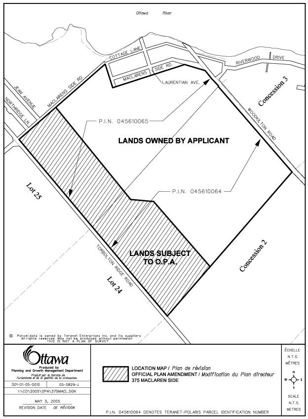
The lands at 375 MacLarens Side Road are bounded by MacLarens Side Road to the north, on the west by Torbolton Ridge Road, on the east by Woodkilton Road and to the south by a mix of active farmlands and woodlots (see Document 1). A mix of permanent and cottage type residential units can also be found along the north side of MacLarens Side Road and along portions of the east side of Woodkilton Road.
The subject property consists of a mix of woodlots, stream courses, rock outcrops and agricultural land uses. The western edge of the subject lands along Torbolton Ridge Road represent the highest elevation of the property. At this elevation the lands are comprised of wooded pasture and two, separated, cropped fields. This upper portion of the subject lands ends abruptly at a steep drop (escarpment) into an open area, which is used as an unimproved pasture.
The applicant’s total land holding comprises an area of approximately 113.2 hectares. Current land uses on the property represent a mix of woodlots and agricultural land uses.
In March of 2005 the property owner of 375 MacLarens Side Road and his consultant met with City staff to review the submission requirements for an Official Plan Amendment. A proposal was outlined to redesignate a portion of the subject lands from agriculture to a designation that would support a future country estate lot development.
Shortly after meeting with City staff the owner’s consultant submitted a request to amend the City’s Official Plan from “Agricultural Resource Area to General Rural Area”. Accompanying the application was a Planning Rationale Report and a Soil Survey and Canada Land Inventory Classification Report.
DISCUSSION
The lands are designated “Agricultural Resource Area” in the City Council Approved Official Plan and in the former Region of Ottawa-Carleton Official Plan and the Township of West Carleton Official Plan. The owner has indicated that a plan of subdivision and Zoning By-law amendment for the lands will be submitted to the City should the Official Plan Amendment be approved. The applicant proposes to redesignate approximately 40.7 hectares of the 113.2 hectares from “Agricultural Resource to General Rural Area”.
The City Council Approved Official Plan set out criteria that must be satisfied when considering amendments to the Official Plan. In addition, amendments to an Official Plan shall be consistent with the Provincial Policy Statements. These criteria are provided below.
Section 5.2.2 of the City Council Approved Official Plan states;
1. When considering amendments to this Plan, the City will have regard to, among other things, the following criteria:
a) The impact of the proposed change on the achievement of the policies expressed in this Plan;
b) The effect of the proposed change on neighbouring communities;
c) The effect of the proposed change on the need for water, wastewater and transportation services;
2. When considering amendments that affect the use of a specific site or sites, the City will also consider whether there is a need to add the site or sites to the lands already designated for the proposed use.
The Provincial Policy Statement
(PPS) states:
“Prime
agricultural areas shall be protected for long-term use for agriculture. Prime
agricultural areas are areas where prime agricultural lands predominate. Specialty crop areas shall be given the
highest priority for protection, followed by Classes 1, 2 and 3 soils, in this
order of priority.” Document 3 explains
in greater detail the applicable Provincial Policy when considering an Official
Plan amendment.
The supporting documentation to this application clearly identifies the variety of soil conditions on the lands subject to this amendment. The City Council Approved Official Plan and the Provincial Policy Statement (PPS) considers Class 1-3 soils as prime agricultural areas. Of the total land holding (113.2 hectares), 70.2% is with in the range of what is considered the top three soil categories (Class 1 – 3).
When calculating the area subject of the amendment (40.7 hectares) 57.6% of the lands fall within the top three soil categories, with the majority of these lands having a Class 3 rating. The Soil Survey Report also notes that the soil units in the amendment area do not form a contiguous unit of Class 3 soils. These soil units are comprised of complex soil units and small units of pure Class 3 soils. Escarpment features and the eroded stream channels effectively limit the production of mechanized agriculture. Further, the consultant notes that the lands on the upper part of the escarpment do not represent a pure soil unit, and are considered to be in a combined soil classification due to the undulating nature of the underlying bedrock. Given the combined class of soils an alternative method of assessment, known as the Hoffman Indices has been applied. The alternative method, which is an accepted practice by the Ontario Ministry of Agriculture, reduces the overall average of 57.6% of Class 1 –3 to about 25 %.
The applicant has demonstrated that the soils on the lands subject to the proposed amendment are not of a high agricultural value; however, the value of agricultural land is not determined by soils alone. The autonomy and operational ease of adjacent lands are impacted by the proposed development and this must be factored into staff’s recommendation rationale. Agricultural land as defined by the PPS is predominate in this area. The amendment lands represent the northerly most section of a large tract of agricultural land. The same argument being put forward to rationalize this Official Plan Amendment is the argument that could be used to further redesignate the remaining agricultural parcel in the future.
The MacLarens Landing development has existed for a number of years in harmony with the adjacent lands. The expectations of residents of a new development may be quite different than those of the cottage-residential development in MacLarens Landing.
The applicant has provided information based on the Minimum Distance Separation (MDS) which has been calculated for the existing barns on and adjacent to the subject lands. Only one barn (main barn) has been identified as a possible impact on the amendment lands. The Report does not address the issue of impacts and what limitations will be imposed on the remaining farm parcel should the operation change or expand in the future.
Further, the application has not demonstrated a need for additional land to be designated to accommodate the creation of residential estate lots as required by the Provincial Policy Statement. According to the City of Ottawa Draft Rural Residential Land Survey (2004-2005 update) there is potential for 5,433 vacant residential lots in the West Carleton Ward. This amount is derived by adding together the unit potential on lands currently designated for residential and the current development applications before the City, i.e. pending, draft approved and registered plans of subdivisions.
This application does not satisfy the tests as outlined in the City Council Approved Official Plan and the Provincial Policy Statement, and therefore, the Department recommends the refusal of this application.
Approval of the amendment will impact on the viability of agriculture on the subject lands and in the immediate agricultural community.
CONSULTATION
Notice of this application was carried out in accordance with the City's Public Notification and Consultation Policy. The Ward Councillor is aware of this application and the staff recommendation.
Detailed responses to the notification/circulation are provided in Document 2.
FINANCIAL IMPLICATIONS
N/A
APPLICATION PROCESS TIMELINE STATUS
This application was not processed by the "On Time Decision Date" established for the processing of Official Plan amendments due to the complexity of the issues associated with the the information provided in support of the application in additon to a request to have the application put on hold by the owner.
SUPPORTING
DOCUMENTATION
Document 2 Consultation Details
Document 3 Provincial Policy Statement Details
DISPOSITION
Corporate Services Department, City Clerk’s
Branch, Secretariat Services to notify the owner, Jack MacLaren, 114 Creekside
Drive, Woodlawn, ON K0A 3M0, applicant,
McIntosh Perry Consulting Engineers Ltd., 115 Walgreen Road, Carp, ON K0A 1L0, Signs.ca, 866 Campbell Avenue,
Ottawa, ON, K2A 2C5, Ghislain Lamarche, Program Manager, Assessment, Financial
Services Branch (Mail Code: 26-76) of
City Council’s decision.
LOCATION MAP DOCUMENT
1
CONSULTATION DETAILS DOCUMENT
2
This application was subject to the
Public Notification and Consultation Policy.
PUBLIC COMMENTS
Resident of Maclarens Landing does not want a plan of subdivision. It is a rural community with dirt roads. We do not want our community to be affected by a subdivision at this location.
COUNCILLOR’S COMMENTS
Councillor Eli El-Chantiry is aware of the application
COMMUNITY ORGANIZATION COMMENTS
MacLaren Community Association has some concerns. Would like to be kept abreast of any meetings and approvals.
ADVISORY COMMITTEE COMMENTS
Ottawa Forests and Greenspace Advisory
Committee
This is an application to change a 40.7 ha
parcel of land designated as Agricultural Resource Area in the Official Plan to
General Rural. The site, located close
to but not bordering the Ottawa River, is not within a village, as defined in
the Official Plan. Approximately 1/3 of the MacLaren holding between Torbolton
Ridge Road and Woodkilton Road is proposed for re-designation. All or part of the entire land holding is
currently farmed.
The applicant has provided soils survey data to
show that the land is not good agriculture land although it is being actively
farmed.
The Ottawa Forests and Greenspace Advisory
Committee opposes the re-designation of this land on the following
principles/for the following reasons:
- Rural
residential development does not conform to the Official Plan intent to
intensify within the urban boundary.
- As
shown in the Rural Residential Vacant Land Survey 2003 Report – ACS2005-PGM-POL-0041) presented to
Planning and Environment on June 28, 2005, there are 18,691.75 ha
comprising 26,850 units of vacant land available for development outside
the Urban Boundary. 6,558 of those
units (24% of the City’s available supply) are in West Carleton, so there
is no shortage of rural land available for development. There is no need for this
re-designation
- Additional
rural development so far from the core will put pressure on the City to
provide services, will increase vehicular traffic on roads in an area not
served by public transit, and will increase the strain on the groundwater
supply and require additional septic services.
- Although
the land proposed for re-designation is said to be largely of low quality,
the CLI classes are given for the entire site, not for the land that is
proposed for an Official Plan Amendment.
- The
land is designated Agricultural Resource, a category of land that is to be
protected from development.
- Some
of the land proposed for re-designation is wooded (described as wooded
pasture land in the consultants report) and removal of that forest will
further erode the city’s ability to meet its 30% forest cover target as
outlined in the OP
Ottawa Forests and Greenspace Advisory Committee Conclusions and
Recommendations
Refuse the Official Plan amendment
request as it does not conform to the City Council Approved Official Plan.
PROVINCIAL POLICY STATEMENT DETAILS DOCUMENT 3
2.3.3 Permitted Uses
2.3.3.1 In prime agricultural
areas, permitted uses and activities are: agricultural uses, secondary uses and agriculture-related uses. Proposed new secondary uses and agriculture-related
uses shall be compatible with, and shall not hinder, surrounding
agricultural operations. These uses shall be limited in scale, and criteria for
these uses shall be included in municipal planning documents as recommended by
the Province, or based on municipal approaches which achieve the same
objective.
2.3.3.2 In prime agricultural areas,
all types, sizes and intensities of agricultural
uses and normal farm practices
shall be promoted and protected in accordance with provincial standards.
2.3.3.3 New land uses, including the creation of lots, and new or
expanding livestock facilities shall comply with the minimum distance separation formulae.
2.3.4.3 The creation of new residential lots in prime agricultural areas shall not be
permitted, except in accordance with policy 2.3.4.1(c).
2.3.5 Removal of Land from Prime Agricultural Areas
2.3.5.1 Planning authorities may only exclude land from prime agricultural areas for:
a)
expansions
of or identification of settlement areas
in accordance with policy 1.1.3.9;
b)
extraction
of minerals, petroleum resources and mineral aggregate resources, in
accordance with policies 2.4 and 2.5; and
c)
limited
non-residential uses, provided that:
- the land
does not comprise a specialty crop
area;
- there is a
demonstrated need within the planning horizon provided for in policy
1.1.2 for additional land to be designated to accommodate the proposed
use;
- there are
no reasonable alternative locations which avoid prime agricultural areas; and
- there are no reasonable alternative
locations in prime agricultural areas
with lower priority agricultural lands.
2.3.5.2 Impacts from any new or expanding non-agricultural uses on
surrounding agricultural operations and lands should be mitigated to the extent
feasible.
The Provincial Policy Statement defines Prime Agricultural Areas as:
areas where prime agricultural lands predominate. This includes: areas of prime agricultural lands and associated Canada Land Inventory Class 4-7 soils; and additional areas where there is a local concentration of farms which exhibit characteristics of ongoing agriculture. Prime agricultural areas may be identified by the Ontario Ministry of Agriculture and Food using evaluation procedures established by the Province as amended from time to time, or may also be identified through an alternative agricultural land evaluation system approved by the Province