Report to / Rapport au:
Mobility Issues Advisory Committee
Comité consultatif sur les questions de mobilité
9 October 2002 / le 9 octobre 2002
Submitted by / Soumis par: David Gladstone, Member /
Membre
Contact /
Personne-ressource: Robbie Tremblay, Coordinator / Coordonnateur, Mobility Issues Advisory Committee /
Comité consultatif sur les questions de mobilité
580-2424 ext. / poste 28135 / rob.tremblay@ottawa.ca
|
|
|
|
|
SUBJECT: |
ALTA
VISTA TRANSPORTATION CORRIDOR – ENVIRONMENTAL
ASSESSMENT STUDY |
|
OBJET : |
COULOIR
DE CIRCULATION D’ALTA VISTA – ÉTUDE D’ÉVALUATION ENVIRONNEMENTALE |
REPORT RECOMMENDATION
That the Mobility Issues Advisory Committee receive
the above-noted item for discussion.
RECOMMANDATION DU RAPPORT
Que le comité consultatif
sur les questions de mobilité prenne connaissance du rapport précité en vue d’en discuter.
PURPOSE
Member D. Gladstone is the
Mobility Issues Advisory Committee representative on the Public Advisory
Committee for the Alta Vista Transportation Corridor Environmental Assessment
Study. He has provided updates on the
progress of the group’s work and participated in various meetings and sessions.
At
his request, it was agreed to include the following report for discussion in
order to establish a position before the next steps for the Environmental
Assessment are considered at the Transportation and Transit Committee.
DISCUSSION
Member D. Gladstone presents the following comments:
“The Alta Vista
Transportation Corridor is a contentious issue, starting with its name and
origins. Calling it a transportation corridor goes back two years,
when opponents of what the Official Plan terms ‘The Alta Vista Parkway’
convinced City staff and Council to use a neutral term in the terms of
reference of the EA. As for its origins, provision for a road south from
what is now the Nicholas off-ramp from the Queensway (the railway connection to
Union Station until the early 1960's) is made in the 1950 Gréber Report. I don't know the details, but it's clear
that the land that now constitutes the Alta Vista transportation corridor,
running from the Queensway to Hunt Club Road was reserved for the NCC, before
the residential development of Alta Vista began. By 1976, the corridor
was RMOC property and reserved for a future 'Parkway'.
I have never seen a
detailed explanation of why the long-planned Parkway wasn't built, but I see it
as resulting from a combination of the strong opposition of residents of Ottawa
East and Sandy Hill to any road link to Nicholas at the Queensway, the cost of
building the road, and the obvious fact that the existing transportation
network meets the needs of Alta Vista residents. The current EA
was, in fact, not prompted by a perceived urgent need to build the full road,
but rather by car traffic concerns in the environs of the growing hospital
complex north of Smyth Road.
Debate over the need for
the EA and its terms of reference was vigorous, with community associations to
its north solidly opposed to any road linking Nicholas, and insisting on neutral
terms of reference. Thy have been joined by many residents of Alta Vista
opposed to the loss of greenspace and garden plots. The degree of
community concern over the EA was demonstrated by the attendance of 1,000
residents at two public meetings in November and December 2001.
These concerns led to the
establishment of a Public Advisory Committee with substantial representation
from community groups, including MIAC. PAC meetings have been
lengthy, with many repeatedly expressed concerns over the consideration of road
options in the corridor. The Terms of Reference provide for mid-study
reports to TTC, the first being due this fall.
Information provided to
the PAC by the consultant, Delcan, has confirmed that both Nicholas and the
Queensway are near capacity at peak hours, while the East and South Transitways
have unused capacities. This information has not been applied by the
consultant to-date, as the study methodology he has developed requires the
evaluation of the overall desirability of all options before examining their
cost and feasibility.
Briefly, my
recommendation is that MIAC take the following position on the EA:
·
Endorse the continued conduct of a comprehensive EA
aimed at determining the best use of the corridor lands for transportation,
greenspace, and development;
·
Strongly support options that will increase the
modal share of walking, cycling, and transit;
·
Question the usefulness of continued consideration
of road options that link with Nicholas Street;
·
Support the comprehensive examination of the impact
of the various options on air quality.”
CONSULTATION
The Transportation, Utilities and Public Works
Department will be circulated on this report and provided the opportunity to
address any comments or concerns raised by the Advisory Committee.
ATTACHMENTS
Attachment 1 – Environmental Assessment Study Draft Terms of Reference
Attachment 2 – Original Public Advisory Committee and Public Consultation Schedule
DISPOSITON
Chair and Committee Coordinator will forward the
Advisory Committee’s submission to be included in the departmental report.
Attachment 1
Report to/Rapport à:
Transportation and Transit Committee/
Comité des transports et des
services de transport en commun
and Council/et au Conseil
8 February 2001/8 février 2001
Submitted by/Soumis par: Ned Lathrop, General Manager/Directeur général,
Development Services/Services de développement communautaire
|
|
Ref N°:
ACS2001-DEV-POL-0003 |
|
SUBJECT: |
ALTA VISTA PARKWAY
ENVIRONMENTAL ASSESSMENT STUDY DRAFT TERMS OF REFERENCE |
|
OBJET: |
ÉBAUCHE DU MANDAT DE L'ETUDE ENVIRONNEMENTALE DU PROJET
DE LA PROMENADE ALTA VISTA |
REPORT
RECOMMENDATION
That the Transportation Committee recommend Council approve the draft study terms of reference as a basis for the Alta Vista Parkway environmental assessment to be initiated this year.
RECOMMENDATION DU RAPPORT
Que le Comité des transports et des services de transports en commun recommande au Conseil d'approuver le mandat pour la base de l'étude environnementale de la promenade Alta Vista, laquelle sera initiée cette année.
BACKGROUND
At their meeting on the 13 September 2000, Regional
Council adopted the recommendations of the Alta Vista Drive/Smyth Road
Transportation Strategy as contained in the Technical Study Report prepared by
Delcan Consultants, in particular #7
"To ensure the timely delivery of the section of the Alta Vista
Parkway between Smyth Road and Riverside Drive (with links to the Hospital Ring
Road), and the ramps to the Southeast Transitway, appropriate funds need to be
identified in the five year Budget of the new City of Ottawa to complete the
Environmental Assessment Study of the Alta Vista Parkway between Conroy Road
and the Queensway.”
The Alta Vista/Smyth Transportation Strategy had
been carried out to determine the transportation infrastructure needs and
timing to accommodate the anticipated development being planned and implemented
in the vicinity of the Ottawa Hospitals Complex in Southeast Ottawa. (Copies of the Report can be obtained by
contacting Chris Gordon at ext. 22783 or through the City’s internet site, MOE
- http://moe/main/navigation/en/cityframeRMOCAgendas.html - Sept 6, 2000
Documents).
Among the many transportation infrastructure needs
identified was that of requiring the first phase of the proposed Alta Vista
Parkway (Smyth Road to Riverside Drive) to be in place by the end of the
10-year planning horizon i.e. by approximately 2010.
In addition to the recommendations of the Alta
Vista/Smyth Study, Regional Council also adopted the following directions to
staff:
“2. That Recommendation #7 of the Delcan Study be amended to
ensure that when doing the Environmental Assessment, the Alta Vista Parkway be
studied as a "bus/light rail only" route and as a
"transit/vehicle route",
“3. That the next phase (i.e. phase 2) of the Alta Vista Parkway
will consider the extension of the transitway from Smyth Road to Conroy Road
and that the Environmental Assessment reflect this amendment", and
“6. That all Terms of Reference be approved by the Transportation
Committee for Transportation Studies".
DISCUSSION/DRAFT TERMS OF REFERENCE
The Project / The Undertaking
The Alta Vista Parkway has been identified as a
future roadway requirement in all the Regional Official Plans since 1974 and
was reconfirmed as a future need in the 1997 Transportation Master Plan and
Regional Official Plan.
The proposed Alta Vista Parkway is the logical
extension to the Conroy Road Corridor upgrade, which was completed in 1999.
The fundamental purpose of the Conroy/Alta Vista
Parkway Corridor is to provide additional arterial capacity in the Southeast
Sector of the City of Ottawa to serve the urban development that has been
planned and implemented there since the 1974 Regional Official Plan.
The form and function of this transportation
facility is to be determined through the environmental assessment process,
which will satisfy the requirements of the Provincial and Federal EA
legislation. With effective public
consultation, the most appropriate solution will be developed and recommended.
This EA Study could take approximately 15 months to
complete. There is urgency to get
underway with the Study as soon as possible to meet the anticipated need for
the section of the Alta Vista Parkway between Smyth Road and Riverside Drive
(due to the quickly developing Health Science Center).
The major tasks for this project will be as follows:
1. Need and Justification
Although the Transportation Master Plan (TMP)
identified the need for this transportation facility and this has been
augmented recently by the Alta Vista/Smyth Transportation Strategy, a
re-examination of need and assumptions is required to reaffirm the TMP
conclusions. This exercise will be
carried out by forecasting travel demand for the Southeast Sector and
determining both existing and future needs for the facility. The basis for this analysis will be
primarily from past work such as the Environmental Assessment Study of
Transportation Demands To and From the Southeast Sector (1994), the City of
Ottawa’s Alta Vista/Smyth Study(1996), the Region’s Alta Vista Drive/Smyth Road
Transportation Strategy(2000) and the recently completed Train Lands Development
Traffic Impact Study. An examination of
future traffic levels across screenlines and study area intersection level of
service will also supplement the review.
The travel demand analysis must consider various Transportation Demand
Management trip strategies including enhanced transit service in the corridor
in accordance with TMP and ROP policies.
2. Existing Conditions
As with every EA, an inventory and assessment of the
various existing conditions must be undertaken. These include, but are not
limited to transportation, land use, utilities, social/human environment,
physical environment, and natural environment.
In addition, the Study will include investigations of any special
aspects of the study area that should also be considered. For example: the effects on the Rideau
River, the effects of noise on the adjacent communities, any archaeological
potential, and the environmental implications of construction in the vicinity
of the Rideau River at Lees Avenue.
3. Evaluation Criteria and Evaluation Process
A list and description of the criteria to be used to
evaluate the various alternatives will be developed. A detailed evaluation methodology will also be described and
documented.
4. Alternatives to the Undertaking and
Alternatives to the Alignments
The TMP recommended the Alta Vista Parkway be a new
four lane arterial roadway with the lane configurations to be assessed in
accordance with past Council directions.
This Study will also investigate many infrastructure options such as a
bus/rail only corridor and transit/HOV lanes and mixed-use facilities. Other aspects of the corridor such as
bicycle lanes, recreational paths, sidewalks, lighting, grade separation, etc.
will be included. The different options
developed with the public will be presented at several public open houses
throughout the project (see Communication Plan section). Developing and examining a full range of
options complies with the EA Act requirement that alternative solutions for the
undertaking be assessed.
5. Recommended Plan
Following the evaluation of alternatives, the
Project Team will refine the most appropriate alignment, cross section and
configuration, taking into consideration all necessary mitigation measures
required to minimize any adverse impacts of the facility. To ensure that all of
the impacts are identified, it would be appropriate to carry out studies such
as noise, air quality, stormwater management, geotechnical surveys, landscape
design, property impacts and any other research that would be required to
properly define the cumulative effects of the facility, in accordance with the
EA requirements. The recommended plan will include a coordinated centre-line,
property envelope, construction stages, plan and preliminary cost estimates for
budgetary purposes.
6. Environmental Study Report (ESR)
The Consultant is required to prepare an ESR to
document the entire process. A draft ESR will be circulated to the Project
Team, Technical Advisory Committee, Special Advisory Group, Public Advisory
Committee and any other approval agencies for comment. A final ESR,
incorporating all pertinent comments, will be prepared and distributed to the
public for the formal 30-day Review Period as outlined in the Class
Environmental Assessment requirements.
ENVIRONMENTAL IMPLICATIONS
All environmental impacts will be assessed in this
study. In addition, special
investigations will take place in the vicinity of the Rideau River crossing
where pollution of the Rideau River occurred during the construction of the
Southeast Transitway.
CONSULTATION
There will be a comprehensive communications and
public consultation effort to ensure that all stakeholders are aware of the
project and have an opportunity to provide input in a timely manner. The Communications Plan consists of Study
notifications and the consultation program.
Notifications
The public will be informed of the Study
commencement, public meetings (Open Houses), and Study completion. Notifications will be sent out at
appropriate stages in the Study, and each announcement will take the following
forms:
·
advertisements
in daily newspapers (The Ottawa Citizen, The Ottawa Sun, Le Droit);
·
advertisements
in community papers (The Centretown News, The Alta Vista News, The Hunt Club
News, the Vistas, L’Image);
·
mail
drop flyers to study area residents;
·
road
signs along the study corridor (at Walkley Road, Smyth Road, Riverside Drive,
Alta Vista Drive, Lees Avenue); and
·
City’s
website - dedicated specifically to this project.
Councillors will be informed
in advance of any public notification regarding this project. Councillors will also have the opportunity
to attend status update meetings, which will typically be scheduled in advance
of public open houses.
Consultation
The consultation program
consists of meetings with stakeholders through advisory committees, and
meetings with the general public through Open Houses. Stakeholders will be organized into various groups, which will
meet with the Study Team at key stages to review and comment on the Study
findings. Each advisory group meeting
will be chaired by the Study Team’s Project Manager. The 3 advisory groups are:
·
Technical
Advisory Committee (TAC)
·
Special
Advisory Group (Hospitals, Health Care Agencies, etc.)
·
Public
Advisory Committee (PAC)
The Technical Advisory Committee
will comprise of government agencies and approval bodies with representation
from the:
·
NCC
·
Ministry
of the Environment (MOE)
·
Ministry
of Transportation (MTO)
·
Canadian
National Railway/VIA Rail
·
Transport
Canada
·
City’s
Transportation, Utilities, and Public Works Department
à
Traffic
and Parking Operations
à
Transit Services
à
Infrastructure Services
·
City’s
Development Services Department
à
Planning,
Environment and Infrastructure Policy
à
Planning
and Infrastructure Approvals
à
Building
Services
·
Conservation
Authorities
Due to the nature of the
study area and the importance of the regional health care facilities and
hospitals, a Special Advisory Group to deal with site-specific issues will have
to be established. This Group will be
consulted on matters such as specific development plans, access and egress
issues, and environmental issues. This
Special Advisory Group will have representation from the:
·
Canadian
Blood Services;
·
Canadian
Dental Association;
·
Canadian
Medical Association;
·
Canadian
Pharmacists Association;
·
Children’s
Hospital of Eastern Ontario (CHEO) and Research Institute;
·
Conference
Board of Canada;
·
General
Hospital and Eye Institute; and
·
National
Defense Medical Centre.
The study area for the Alta
Vista Parkway spans many different communities with their own characteristics,
needs, and values. In order to fully
address both local and regional issues, a Public Advisory Committee will be
established with representation from:
·
Ottawa
East(including Rideauview)
·
Sandy
Hill
·
Alta
Vista(including Riverview Heights, Faircrest Heights and Canterbury)
·
Greenboro(including
South Keys and Hunt Club Park)
·
Special
Interests - pedestrians, cyclists, transit, environmental and social groups
In addition to the Advisory
groups, the Project Team will consult with the general public at three planned
Open Houses. Information for review and
comment at these formal Open Houses could be as follows:
|
Open House #1 |
Open House #2 |
Open House #3 |
|
·
Introduction ·
Study Purpose ·
Need and Justification ·
Study Process & Schedule ·
Existing Conditions ·
Alternatives to the Undertaking ·
Evaluation Criteria ·
Preliminary Screening of ·
Alternatives ·
Next Steps |
·
Development of Options ·
Evaluation Criteria ·
Assessment of Options ·
Environmental Effects ·
Next Steps |
·
Recommended Option ·
Mitigation Plan ·
Next Steps |
At all Open Houses, there will be bilingual
representatives from the Project Team and all presentation material will be in
both official languages.
FINANCIAL IMPLICATIONS
There are no immediate financial implications by
approving this report.
The proposed 2001 Capital Budget includes the
funding for the completion of the Environmental Assessment. Any funding
requirements as a result of the recommendations from the study will be included
in future City of Ottawa Budgets as construction is approved.
ATTACHMENTS
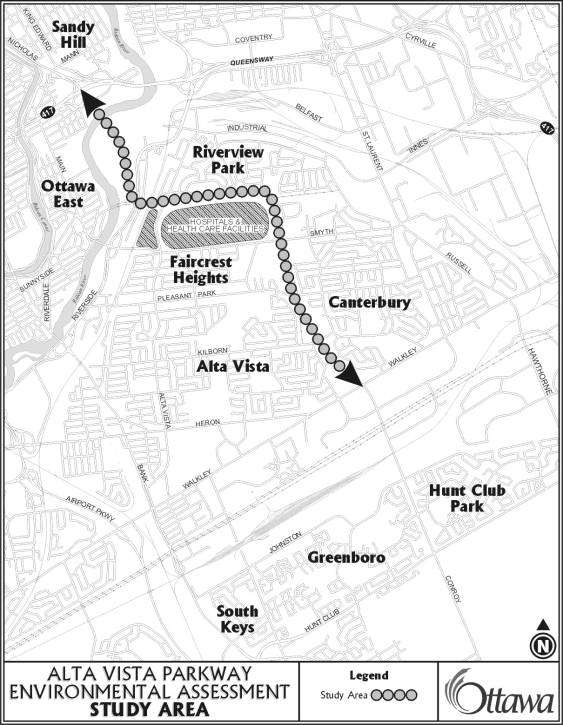
Document 1 - Alta Vista Parkway Environmental
Assessment Study Area
DISPOSITION
Following Committee and Council approval of this
draft Study Terms of Reference, the originating department will prepare a
detailed study design for the consultant assignment. The consultant selection process will follow the established
practice with the posting of the Proposal Call on MERX.
Alta Vista Parkway Environmental Assessment Study Area Document 1
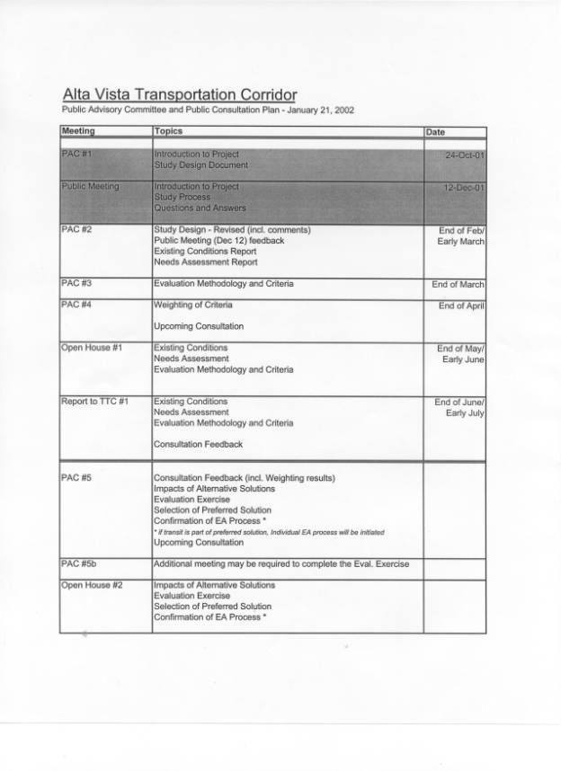
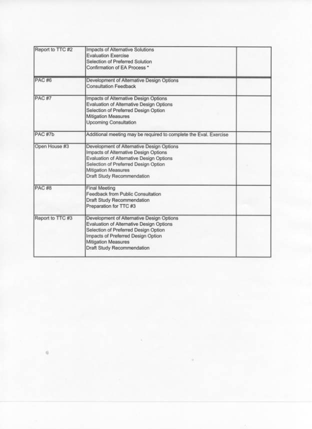
Original Public Advisory Committee and Public Consultation Plan Attachment 2