|
4. ZONING
– 5676 MANOTICK MAIN STREET ZONAGE
– 5676, RUE MANOTICK MAIN |
Committee
recommendation as amended
That Council approve an amendment to the Zoning By-law
2008-250 to change the zoning of 5676 Manotick Main Street, from Development
Reserve, Subzone 1 (DR1) and Village Residential
First Density, Subzone P (V1P) to Village
Residential First Density, Subzone Q (V1Q), Village Residential First
Density, Subzone Q Exception (V1Q[xxxr]), Village
Residential Third Density, Subzone B Exception (V3B[yyyr]) and Parks and Open
Space (O1), as shown in Document 1 and detailed in Document 2, as
amended by the following:
WHEREAS Report
ACS2012-ICS-PGM-0070 recommends zoning changes to the lands known municipally
as 5676 Manotick Main;
AND WHEREAS Document 1
erroneously indentifies the proposed zoning of Lot 130 to be V1Q instead of
V3B[yyyr] as intended;
AND WHEREAS Document 2
also needs to be revised;
BE IT RESOLVED that the following change be made to the staff
report:
1. That Document 1 – Location Map/Zoning Key Plan and
Document 2 - Details of Recommended
Zoning be replaced with the revised Documents 1 and 2 attached.
That no further notice be provided pursuant to Section 34(17) of the
Planning Act.
Recommandation
MODIFIÉE DU Comité
Que le Conseil approuve une modification au Règlement de
zonage no 2008-250 en vue de changer le zonage de la propriété située au
5676, rue Manotick Main, de Zone d’aménagement futur, sous-zone 1 (DR1) et de
Zone résidentielle de village de densité 1, sous-zone P (V1P) à Zone
résidentielle de village de densité 1, sous-zone Q (V1Q), Zone résidentielle de
village de densité 1, sous-zone Q avec exception à Zone résidentielle de
village de densité 3, sous-zone B exception (V3B[yyyr]) et à Zone de parc et
d’espace vert (O1), comme le montre le document 1 et l’explique le document 2, telle
que modifiée par ce qui suit :
ATTENDU QUE le rapport ACS2012-ICS-PGM-0070 recommande des modifications
de zonage à la propriété dont l’adresse municipale est le 5676, rue Manotick
Main;
ATTENDU QUE le document 1 désigne à tort le zonage proposé du Lot130
comme étant V1Q plutôt que V3B[yyyr] comme prévu;
ATTENDU QUE le document 2 doit également être révisé;
IL EST RÉSOLU QUE la modification
suivante soit apportée au rapport du personnel :
1.
Que le document 1 – Plan de localisation / Plan repère de zonage, et le
document 2 – Détails du zonage recommandé, soient remplacés par les documents
révisés 1 et 2 ci-joints.
Qu’aucun autre avis ne soit émis
conformément à l’article 34(17) de la Loi
sur l’aménagement du territoire.
Documentation
1. Deputy City Manager’s Report,
Infrastructure Services and Community Sustainability dated 15 February 2012
(ACS2012-ICS-PGM-0070).
2.. Extract of draft minutes, Agriculture
and Rural Affairs Committee meeting of
1 March 2012.
Report to/Rapport au :
Agriculture and Rural
Affairs Committee
Comité de l'agriculture et des
affaires rurales
and Council / et au Conseil
15 February 2012 / le 15 février 2012
Submitted by/Soumis par :
Nancy Schepers, Deputy City Manager/Directrice
municipale adjointe, Infrastructure Services
and Community Sustainability/Services d’infrastructure et Viabilité des
collectivités
Contact
Person/Personne-ressource : Derrick Moodie, Manager/Gestionnaire, Development
Review-Rural Services/Examen des projets d'aménagement-Services ruraux,
Planning and Growth Management/Urbanisme et Gestion de la croissance
(613)
580-2424, 15134 Derrick.Moodie@ottawa.ca
|
SUBJECT: |
|
|
|
|
|
OBJET : |
REPORT RECOMMENDATION
That the Agriculture
and Rural
Affairs Committee recommend Council
approve an amendment to the Zoning By-law 2008-250 to change the zoning of 5676
Manotick Main Street, from Development Reserve, Subzone 1 (DR1) and Village Residential First Density,
Subzone P (V1P) to Village Residential First Density,
Subzone Q (V1Q), Village Residential First Density, Subzone Q Exception (V1Q[xxxr]),
Village Residential Third Density,
Subzone B Exception (V3B[yyyr]) and Parks and Open Space (O1) , as shown in Document 1 and detailed in Document 2.
RECOMMANDATION
DU RAPPORT
Que le Comité de l’agriculture et des affaires
rurales recommande au Conseil d’approuver une modification au Règlement de
zonage no 2008-250 en vue de changer le zonage de la propriété située au 5676,
rue Manotick Main, de Zone d’aménagement futur, sous-zone 1 (DR1) et de Zone
résidentielle de village de densité 1, sous-zone P (V1P) à Zone résidentielle
de village de densité 1, sous-zone Q (V1Q), Zone résidentielle de village de
densité 1, sous-zone Q avec exception à Zone résidentielle de village de
densité 3, sous-zone B exception (V3B[yyyr]) et à Zone de parc et d’espace vert
(O1), comme le montre le document 1 et l’explique le document 2.
BACKGROUND
The subject site is located in the Village of
Manotick and is legally described as Part of Lots 4 and 5 Concession A (Broken
Front) Geographic Township of North Gower, City of Ottawa. The site is bounded
by Manotick Main Street to the east, Century Road to the south, and an unnamed
drain (tributary to the Rideau River) to the west (see Document 1).
The site, known as Minto’s Mahogany Community,
is approximately 25.29 hectares in area, is irregular in shape,
and is made up of a number of different features representing former farm
fields, hedgerows, woodlots and a pond.
Existing residential and some commercial development are located on
Manotick Main Street to the north and east of the subject site.
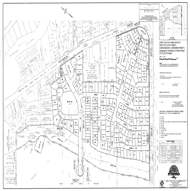
On May 7th, 2010, the Owner filed a Zoning By-law amendment application in support of a proposed plan of subdivision. Subsequently, under delegated authority, staff approved the draft plan of subdivision. A member of the public filed an appeal of this approval, but did not ultimately oppose draft approval when granted by the Board at a hearing held by conference call. As a result, the proposed subdivision (Phase 1) was draft approved by the Ontario Municipal Board (OMB) on October 20, 2011 (see Document 3). The subdivision plan contains a grid‑like pattern of local public streets with widths of 18 metres, two lanes with widths of 8.5 metres and one Collector Road with a width of 22 metres. A secondary access is also provided off of Century Road. A total of 197 residential units have been approved which include single‑detached and small lot singles.
Two park blocks and seven open space blocks are provided in Phase 1 of the development. A block has also been created for the new pumping station that forms part of the Phase 1 development.
Official Plan
In accordance with the Official Plan, the subject site is located at the southern edge of the village and is designated Village, as illustrated on Schedule “A” Rural Policy Plan. The predominant land use in the Village designation is residential and allows a wide range of housing forms and modest employment opportunities in the form of commercial, tourism and small-scale development. The intensity and distribution of lands uses will be determined in the context of the Secondary and Community Design Plans (CDP).
Manotick Secondary
Plan
The Secondary Plan provides detailed policies that state how the Village will develop. The subject site is designated Serviced Development Area in the Village of Manotick Secondary Plan. The Secondary Plan required a comprehensive development concept plan to be prepared for the entire area, including a phasing plan for future development. The development concept plan would form the basis of subsequent plans of subdivision.
Mahogany
Community – Development Concept Plan/Official Plan Amendment 81
As required by the Secondary Plan, the Mahogany Community, Manotick Development Concept Plan (DCP) was prepared in January 2008, which included the first phase of this development site.
In order to implement the DCP, an amendment to the Manotick Secondary Plan was required. The amendment to the secondary plan was approved by the OMB in April of 2009 (Amendment No. 81). The DCP Land Use Concept Plan became Schedule B to the Official Plan Amendment (OPA) 81. The Phase 1 land as illustrated in the DCP Land Use Concept Plan identifies several land uses, including Single Family (Moderate Density), Mixed Residential, Parks and Open Space, Neighbourhood Amenity Area, Watercourse and Development Setback.
Aside from revisions to land use, phasing and growth management policies, OPA 81 also introduced density targets for the five phases of development.
The Phase 1 draft plan of subdivision was approved for a total of 197 residential units, consisting of 146 single-detached dwellings (moderate density) and 51 small lot singles. The small lot singles is a housing form that is considered Mixed Residential. The DCP allows for a maximum of 25% of this type of housing unit to be integrated throughout the residential development.
Based on the approved OPA, Single Family (Moderate Density) may have a density up to 16 units per gross residential hectare. The residential area for Moderate Density is 10.2 ha. The area for Roads is assumed to be 17%, which is based on the City of Ottawa’s Rural Residential Land Survey 2006 Update. Seventeen percent of 10.2 ha equates to 1.73 ha respectively. The total gross residential area is 11.93 hectare for this land use designation.
The following tables demonstrate the density calculations proposed for the single family detached in Phase 1 (moderate density).
|
Single (Moderate Density) |
Hectares |
|
Gross area |
10.2 |
|
Plus 17% roads |
1.73 |
|
Total gross residential area |
11.93 |
Number of Units = 146
|
Actual Units per ha. |
12.2 u/ha |
|
OPA Density Permitted |
16 u/ha |
Mixed Residential (small lot singles) areas may have a density of up to 35 units per gross residential hectare, and in Phase 1 consist of small lot singles.
The following tables demonstrate the density calculations proposed for the mixed residential in Phase 1 (small lot singles).
|
Single (Mixed Residential) |
Hectares |
|
Gross area |
2.0 |
|
Plus 17% roads |
0.34 |
|
Total gross residential area |
2.34 |
Number of Units = 51
|
Mahogany Phase 1 Density |
23.5 u/ha |
|
OPA Density Permitted |
35 u/ha |
The densities for the moderate density (single detached) and Mixed Residential (small lot singles) conform to the densities established in the approved OPA.
Purpose of Zoning Amendment
The purpose of this amendment is to facilitate the development of an approved draft plan of subdivision.
More specifically, this application will
rezone 5676 Manotick Main Street from Development Reserve, Subzone 1 (DR1) and Village
Residential First Density, Subzone P (V1P) to Village
Residential First Density, (new) Subzone Q (V1Q), and V1Q exception Village Residential Third Density, Subzone B exception
(V3B[yyyr]) and Parks and Open Space (O1)
The single detached dwelling units (moderate density) will range from 18.3 metres to 20.5 metres in width with lot depths from 30 to 46 metres. The Mixed Residential units which include small lot singles will measure at least 10.65 metres in width per dwelling unit with a minimum lot depth of 30 metres.
A new subzone and exception will be created to allow for varied setbacks based on the road cross section and modifications to certain setbacks and lot coverage. This will allow garages to be located to the rear or the side of the house instead of protruding beyond the front lot line of the house which provides a better overall streetscape; to address the design of building envelopes on corner lots; and to increase lot coverage since the development will be on full municipal services (i.e. water and sewer). The proposed zoning would allow for a variety of housing types and create an interesting streetscape.
Existing Zoning
The property is currently zoned Development Reserve Subzone 1 (DR1) and
Village Residential First Density, Subzone P (V1P) pursuant to By-law 2008-250. The
DR1 designation is intended to recognize future village development areas and
limit land uses to those that would not preclude development. The DR 1 Zone
allows for a limited range of uses, including: agricultural use, community
garden, emergency service, environmental preserve and education area, forestry
operation, group home, home-based business, one detached dwelling, and park. The VIP designation permits a low
density form of detached dwellings.
Proposed Zoning
The applicant is requesting an amendment to Zoning By-law 2008-250 to rezone the lands from Development Reserve Subzone 1 (DR1) and Village Residential First Density, Subzone P (V1P), to Village Residential First Density (new) Subzone Q (V1Q), and V1Q exception Village Residential Third Density Subzone B exception (V3B[yyyr]) and Parks and Open Space (O1). The amendment will allow for the following permitted uses: detached dwellings, small lot singles, as well as parks and open space areas. Further, the amendment will establish site specific zoning provisions for the various dwelling types, including minimum lot area, lot width, yard setbacks, lot coverage and maximum height. The areas dedicated for parks and open spaces will be zoned accordingly. Similarly, Block 211, the new pumping station will be zoned Parks and Open Space (O1).
The amendment will also identify the natural buffer between Lots 101, to 106 inclusive and Lots 108 to 117 inclusive on the Draft Plan of Subdivision, and the existing dwellings municipally known as 5696, 5706 and 5714 Manotick Main Street.
DISCUSSION
The proposed zoning conforms to the Official Plan policies, particularly as they relate to the Village designation, which directs growth in Villages by protecting parks and open space in keeping with the existing rural character and scale; by providing a range of housing forms; and by providing infrastructure that is integrated with the planned development. The proposed zoning for Phase 1 of Mahogany Community conforms to the OMB approved OPA which implements the DCP.
Aside from the broader land use policies of
the CDP there were a number of objectives and initiatives identified in the CDP
that were site-specific to Phase 1 and dealt with through the approved plan of
subdivision.
In general the Zoning By-law amendment in
concert with the approved draft plan of subdivision has addressed the following
objectives as prescribed by the OPA and DCP for Phase 1.
·
Transportation
Impacts;
·
Endangered
species – butternut;
·
Vegetation
buffers along existing development;
·
Green
entrances to neighbourhoods;
·
Fisheries and – culvert
crossing and stream flows (unnamed drain);
·
Watercourse setbacks (unnamed
drain);
·
Parks and Open Space – Trails
and Pathways;
·
Tree
Planting and landscaping;
·
Design
with nature;
·
Architectural
– generous yard setbacks; and
·
Stormwater
Management.
In addition to the above objectives there were
two specific policies that required special attention in the development of
Phase 1.
Official Plan Amendment
81 Neighbourhood Amenity states:
“A small area of natural
greenspace will be retained around the pond as a neighbourhood amenity and
seasonal wildlife habitat. The permitted
uses in this land use category include trails and pathways. The location and
design of any trails or pathways will need to be approved by the City and the
Rideau Valley Conservation Authority”.
Section 3.3.10 Existing Residential/Commercial of the DCP states:
“This land use category is shown on the Land Use Concept Plan to recognize the existing residential and commercial uses properties along Manotick Main Street.
These uses should continue to function as residential and commercial uses in accordance with the zoning by-law. A landscape buffer of 3 metres to 4.5 metres will be provided between the existing properties within the future residential development”.
The highlights of the proposed zoning amendment are as follows:
With a draft plan of subdivision approved for 197 residential lots, 146 lots will be captured in the Village First Density zone while the remaining 51 lots will be identified in Village Residential Third Density zone. A new subzone and exceptions will be created to address the varied setbacks and modifications to lot coverage and landscape buffers.
As for parkland, Blocks 198 and 207 represent
Minto’s dedication; and will be zoned Parks and Open space (O1).
The first phase of the spine road has
been enhanced with an existing hedgerow.
This hedgerow was identified early in the process as an important
feature to maintain a characteristic similar to rural roadways such as existing
Century and First Line Roads. Identified
as Block 201 on the plan of subdivision, this area will be dedicated to the
City and zoned as Open Space (O1).
Similarly, Blocks 199, 200 and 204 have
been identified as open space blocks.
These blocks have been set aside as community and neighbourhood gateway features.
The blocks contain some mature tree cover and with additional planting
will act as a green entry feature to the Community. The features may also
include a community/village identification signs.
Blocks 209 and 210
represent the unnamed drain and appropriate setbacks from the centreline of the
drain. Special enhancements to the unnamed
drain include fish habitat, butternut compensation, pathways and two pedestrian
crossings. More specifically, the
enhancements can be summarized as a series of wetland complexes with
peninsulas, providing pike habitat, enhanced with tussock plantings and riffle-pools. Woody debris will also be incorporated into
the design. In addition a pathway will
be constructed along the length of the drain from Century Road to Potter
Drive.
Pedestrian
crossings (bridge) will also bisect the drain over to future development lands
west of the drain. Blocks 209 and 210
will be dedicated to the City and zoned as Parks and Open Space (O1).
In addressing the first specific
policy as ordered by the OMB, the applicant (Minto) was instructed to dedicate
to the City for public use the pond. The
pond feature is identified on the approved draft plan of subdivision as Block
207. In addition OPA 81 required that a small area of natural greenspace (Block 208)
be retained around the pond as a neighbourhood amenity and seasonal wildlife
habitat. As noted earlier, Block 207
will be dedicated to the City as a natural feature while Block 208 as noted
previously, will be received as parkland dedication. Both blocks will be zoned as Parks and Open
space (O1).
With respect to the properties along Manotick
Main Street a landscape buffer of 4.5 metres will be
provided between the existing properties within the future residential
development. Aside from the landscape
buffer Minto has also agreed to erect a fence along the perimeters of all the
properties involved. Further, additional
plantings outside the rear yards (in the landscape buffer) of these properties
will be provided. The protection and
location of the landscape buffer strip will be secured via an exception to the
Village Residential First Density zone.
Finally, although identified as a submission requirement with the Zoning By-law amendment application, the traffic impact study was submitted in support of the Plan of Subdivision. This study was reviewed and accepted by the City.
Staff recommends approval of the Zoning By-law amendment.
RURAL IMPLICATIONS
This Zoning By-law amendment is consistent with the Official Plan policies for the Village of Manotick.
CONSULTATION
Notice of this application was carried out in accordance with the City's Public Notification and Consultation Policy. Details of the consultation can be seen in Document 4.
COMMENTS BY THE WARD COUNCILLOR
Councillor Scott Moffatt is aware of the application.
LEGAL IMPLICATIONS
Many of the issues with respect to this matter have
been identified as being addressed through the subdivision process. Therefore,
should the by-law be adopted as recommended and an appeal received, it is
possible that a motion will brought to the Board to dismiss the appeal without
the holding of a hearing. In the event that the recommendation is adopted and
an appeal received, the matter could be handled within staff resources.
It is anticipated that a two to three day hearing
would result. Should the recommendation not be adopted, reasons must be
provided. To have a reasonable prospect of success at the Board, the reasons
would need to raise issues not addressed in the hearing on the official plan
amendment or the plan of subdivision. In such event, an external planner would
need to be retained at an estimated cost of $40,000.
RISK
MANAGEMENT IMPLICATIONS
There are no risk implications associated with this report.
FINANCIAL IMPLICATIONS
In the event of an appeal, it would be necessary to retain an outside planner at an estimated cost of $40,000. Funds are not available from within existing resources; this expense would impact Planning and Growth Management’s 2012 operating status.
ACCESSIBILITY
IMPACT
ENVIRONMENTAL
IMPLICATIONS
In consultation with the Rideau Valley Conservation Authority features such as the unnamed drain and the pond will be enhanced and preserved.
TECHNOLOGY IMPLICATIONS
There are no direct technical implications associated with this report.
CITY STRATEGIC PLAN
The recommended Zoning By-law amendment aligns with the City Strategic Plan by preserving rural villages and ensuring that decisions affecting rural communities are made with input from the rural residents.
APPLICATION PROCESS TIMELINE STATUS
The application was not processed by the "On Time Decision Date" established for the processing of Zoning By-law amendments due to technical issues associated with the approval of the draft plan of subdivision.
SUPPORTING DOCUMENTATION
Document 1 Location and Zoning Key Map
Document 2 Details of Recommended Zoning
Document 3 Approved Plan of Subdivision
Document 4 Consultation Details
DISPOSITION
City Clerk and Solicitor Department, Legislative Services to notify the owner, applicant, OttawaScene Canada Signs, 1565 Chatelain Avenue, Ottawa, ON K1Z 8B5, Ghislain Lamarche, Program Manager, Assessment, Financial Services Branch (Mail Code: 26-76) of City Council’s decision.
Planning and Growth Management to prepare the implementing by-law, forward to Legal Services and undertake the statutory notification.
Legal Services to forward the implementing by-law to City Council.
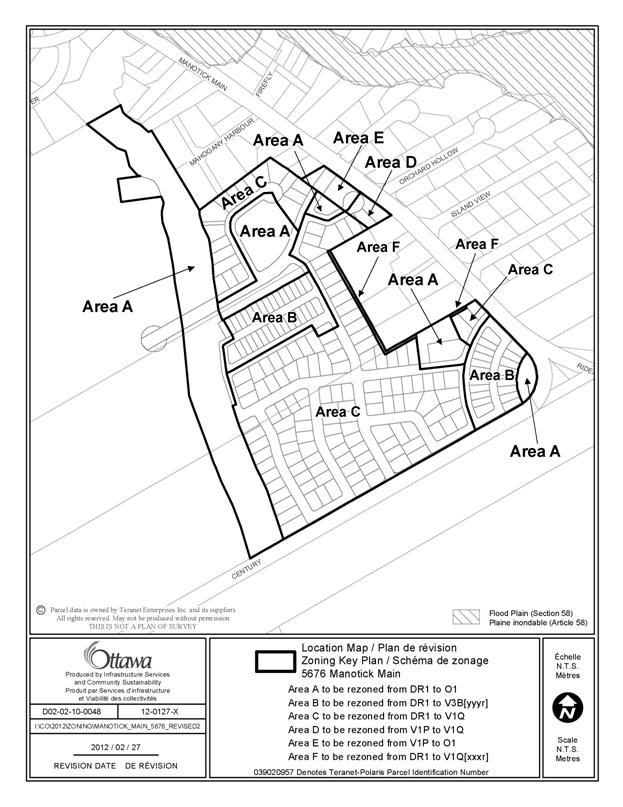
LOCATION MAP REVISED
DOCUMENT 1
DETAILS OF RECOMMENDED ZONING REVISED DOCUMENT 2
Proposed Changes to the Comprehensive Zoning By-law 2008-250
1. Rezone the subject lands shown on Document 2 as follows:
Area A from DR1 to O1
Area B from DR1 to V3B[yyyr]
Area C from DR1 to V1Q
Area D from V1P to V1Q
Area E from V1P to O1
Area F from DR1 to V1Q[xxxr]
2. A new Subzone (Q) will be added to Section 232, Table 232; and will include the following provisions:
|
I |
II |
III |
IV |
V |
VI |
VII |
VIII |
IX |
|
(q) V1Q |
540 |
18 |
3 |
1.2 |
3 |
6m for one-storey 7.5 for two-storey. |
50 |
11 |
3. A new exception, V1Q[xxxr], will be
added to Section 240 and will include provisions similar in effect to the
following:
- a landscaped buffer of 4.5 metres in depth is required abutting any lot line abutting the properties at 5696, 5706 and 5714 Manotick Main Street.
- the 4.5 metre landscaped buffer must be maintained in its natural state
4. A new exception, V3B[yyyr], will be added to
Section 240 and will include provisions similar in effect to the following:
- minimum front yard and rear yard setbacks: lots abutting a public
street that is less than 15 metres wide may have an attached garage setback 0.6
metres from the lot line abutting that street and the dwelling must be setback
a minimum of 3.0 metres from the opposite lot line whether the opposite lot
line abuts a street or a park
- minimum interior side yard setback: 0.6 metres, and for interior lots
at least 0.6 m on one side with a total on both sides of 2.0 metres
- minimum corner side yard setback: 4.0 m
- maximum lot coverage: 60%
- maximum density: 35 units per hectare
DRAFT PLAN OF SUBDIVISION DOCUMENT 3
CONSULTATION DETAILS DOCUMENT 4
NOTIFICATION AND CONSULTATION PROCESS
Notification and public consultation was undertaken in accordance with the Public Notification and Public Consultation Policy approved by City Council for Zoning By-law amendments. The Zoning By-law amendment was also presented at the Public Meeting for the Plan of Subdivision which was held on Tuesday November 2nd, 2010 at the Manotick Hall Arena.
PUBLIC COMMENTS
Of the comments received at the Public Meeting and in writing, many of the concerns raised were subdivision design related, traffic impacts, stormwater drainage concerns, protection of the pond, parkland dedication, impacts to adjacent residential properties landscape buffers, etc. These issues were addressed through the Plan of Subdivision process.
COMMUNITY ORGANIZATION COMMENTS
All concerns raised by the Manotick Village Community Association were addressed through the plan of subdivision.
ADVISORY COMMITTEE COMMENTS
Concerns raised by the Ottawa Forest and Greenspace Advisory Committee (OFGAC) were addressed through the plan of subdivision.