|
Clemow
Estate East |
|
Heritage Conservation
District Plan |
|
City of
Ottawa 2011 |

Acknowledgements
 The Clemow Estate East
Heritage Conservation District Plan was a joint effort between the City of
Ottawa and the community. The efforts of the community are gratefully
acknowledged. In particular, the City would like to thank the following people:
The Clemow Estate East
Heritage Conservation District Plan was a joint effort between the City of
Ottawa and the community. The efforts of the community are gratefully
acknowledged. In particular, the City would like to thank the following people:
John McLeod
John Leaning
Cheryl Casey
Gouhar Shemdin
Frank Oates
Joan Bard Miller
Bill Price
Scott Whamond (OBHAC)
Sue Millar (Summer Student)
TABLE OF
CONTENTS
2005 Provincial Policy Statement
4.0 Boundaries of the District
5.0
Statement of Cultural Heritage Value and Description of Heritage
Attributes
5.1 Statement of Cultural Heritage Value
5.2 Description of Heritage Attributes
6.1.4 Urban Growth and Intensification
6.1.5 Development of Central Park
6.1.6 Development of Clemow Estate east
7.0
Heritage Conservation District Guidelines
7.1 General Guidelines for Contributing Buildings
7.1.1 Conservation and Maintenance
7.1.2 Alterations and Additions to Contributing Buildings
7.2 Guidelines for Infill in the Heritage Conservation District
7.3 Alterations Not Requiring a Heritage Permit
7.4 Heritage Permits Issued by City Staff
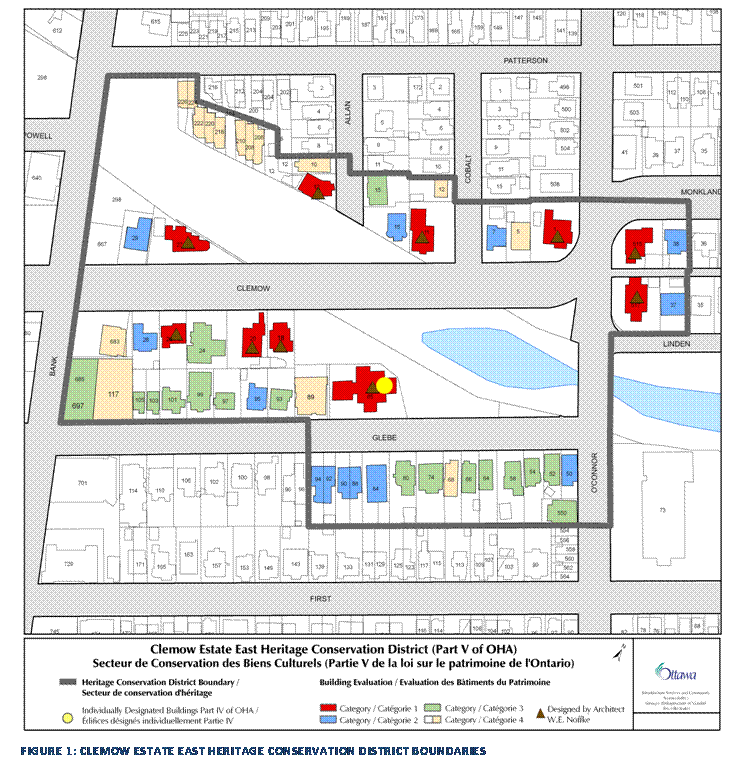
List of Figures
Figure 1: Clemow Estate East Heritage
Conservation District Boundaries
Figure
4: Map of OCPR and OESR Routes in 1891
Figure 6: Proposed Parks in Todd's Plan for
Ottawa
Figure 7: Central Park East from Bank
Street
Figure 8: Central Park and Patterson Creek
Figure 9: Henrietta Adelaide Clemow
Figure 12: Flower Beds in Central Park c.
1911
Figure 16: Champagne Bath, 1922
Figure 17: J.J. Codville House (Now the
Polish Embassy)
Figure 18: Powell House, 85 Glebe Avenue
Figure 19: Plaunt Residence, 1 Clemow
Avenue
Figure 21: Distribution of Architectural
Styles
Figure 25: Powell House, 85 Glebe Avenue
Figure 26: Patterson Creek and O'Connor
Street Bridge
Figure 27: Rock steps from Central Park to
Bank Street
Figure 28: Central Park looking east from
Bank Street
Figure 30: Smooth stucco cladding at 85
Glebe Avenue
Figure 33: Porch on Glebe Avenue
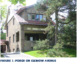
Figure 34: Porch on Clemow Avenue
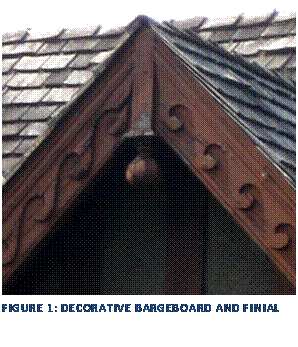
Figure 35: Decorative Bargeboard and Finial
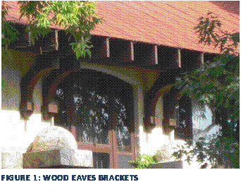
Figure 36: Wood Eaves Brackets
Figure 37: Light Standards and Street Trees
along Clemow Avenue
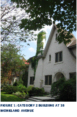
Figure 38: Category 2 Building at 38
Monkland Avenue
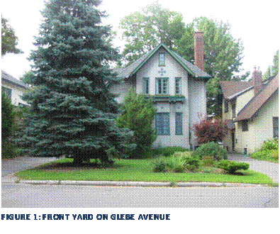
Figure 39: Front Yard on Glebe Avenue
1.0 Plan Summary
The objective of the Clemow Estate East Heritage Conservation District
Plan is to identify the heritage attributes that define
the character of the District and to determine a framework to protect its
cultural heritage value. This will be accomplished through the application of guidelines to
ensure the retention and conservation of the District’s heritage resources and
to provide guidelines for future developments to
complement and enhance the character of the district. The Plan is intended to provide
guidelines for the management of the area to help planners, homeowners,
architects, policy makers and developers to enhance and conserve the area’s
resources
This Plan was developed in three parts: historical and architectural
analysis and study of the District, individual evaluation of the significance
of the buildings located in the proposed district and the development of
guidelines to assist in the management of the area in the future.
Clemow Estate East remains a fashionable upper middle class enclave in Ottawa’s Glebe neighbourhood. Concerns about the future of Noffke’s legacy and the pressures of intensification lead to the request for designation of Clemow Estate East and this study.
2.0 Policy Framework
The Clemow Estate East Heritage Conservation District will be regulated by both municipal and provincial policies. These include Part V of the Ontario Heritage Act, revised 2005, the City of Ottawa Official Plan and the Provincial Policy Statement (PPS).
Ontario
Heritage Act
The Ontario Heritage Act regulates the protection of heritage resources within the province. A property that has been formally protected under the provisions of the Act is referred to as a “designated” property. According to Part V of the Act, as amended on April 28th 2005, the municipality may, by by-law, designate any area as a Heritage Conservation District for its cultural heritage value. If a municipality designates a Heritage Conservation District based on these provisions, a District Plan shall be adopted. The Plan must identify the cultural value and attributes of the District and provides principles for protection.
City
of Ottawa Official Plan
The Official Plan is Ottawa’s guide for the future development of the city. The Official Plan provides a framework for the conservation of heritage buildings in Ottawa. The Clemow Estate East Heritage Conservation District Plan was undertaken under Section 2.5.5.2 :
“Groups of buildings, cultural landscapes, and areas of the city
will be designated as Heritage Conservation Districts under Part V of the
Heritage Act. Any application to alter or demolish buildings which are
individually designated or within a designated Heritage Conservation District
or to construct a new building within a heritage conservation district will be
supported by a cultural heritage impact statement to ensure that the City’s
conservation objectives are achieved.”
2005
Provincial Policy Statement
The purpose of the Provincial Policy Statement, issued under the Planning Act, is to provide municipalities in Ontario with policy direction on matters related to land use planning and development. Part V, Section 2.6 of the PPS provides direction regarding cultural heritage resources. It states:
·
“ Significant built heritage resources and significant cultural
heritage landscapes shall be conserved; and
·
Development and site
alteration may be permitted in adjacent lands to protected heritage property
where the proposed development and site alteration has been evaluated and it
has been demonstrated that the heritage attributes of the protected heritage
property will be conserved.”
3.0 Statement
of Objectives
The primary goal of the Clemow Estate East Heritage Conservation District Plan is to provide a framework and guidelines to ensure the preservation and enhancement of the area known as Clemow Estate East in the Glebe neighbourhood. Clemow Estate East is an area of the Glebe containing a high concentration of houses designed by renowned Ottawa architect, Werner E. Noffke in the early 20th century. The district is centred on Central Park and Patterson Creek, an inlet of the Rideau Canal, and was developed primarily by William Powell and his cousin Henrietta A. Clemow as an upper middle class suburb.
Specifically,
this plan aims to:
·
Ensure the retention and protection of
buildings and landscapes that contribute to the heritage character of Clemow
Estate East.
·
Encourage the ongoing restoration of buildings
of cultural heritage value within the district.
·
Guide change so that new development or
alterations to existing buildings are sympathetic to the heritage character of
the district.
4.0 Boundaries
of the District
The boundary of the HCD includes the eastern portion of the former Clemow Estate, an area of architect-designed houses developed at the beginning of the 20th century with Central Park at its core. Many of these houses were built facing Central Park and hence the District includes Central Park and Patterson Creek area as well. The boundary was developed to include other architect-designed houses and houses that were complementary to the heritage character of the district.
All buildings within the boundaries were evaluated for their contribution to the district. The City of Ottawa uses a scoring system that establishes Categories 1 through 4 for buildings of heritage significance. The scoring formula is tailored to reflect the specific heritage values present in the district. The original reasons for studying this district were the concentration of buildings designed by Noffke and the relationship of these buildings to Central Park. As such, architecture and environment were weighted at 40% of the total score and history was rated at 20%. A committee involving City staff and members of the community established the final scores through consensus. There are a total of 56 buildings in the heritage conservation district. The individual heritage survey forms held on file with the City of Ottawa Planning and Growth Management Department.
Those buildings ranked as Categories 1, 2 and 3 are considered to be “contributing buildings” in the district. These buildings contribute to the overall heritage character and value of the district. Buildings ranked as Category 4 are considered to be “non-contributing” buildings in the district of little heritage significance. Demolition of these buildings could be considered on the merits of the proposed replacement.
5.0 Statement of Cultural Heritage Value and
Description of Heritage Attributes
5.1 Statement of Cultural Heritage Value
The cultural heritage value of Clemow Estate East lies in its development as an early upper middle class suburb in Ottawa centred on a park, and featuring a number of architect-designed houses.
The core of Clemow Estate East is Central Park, an early 20th century park designed as a space for passive recreation and representative of trends in park design and in the beautification of the national capital by the Ottawa Improvement Commission. Central Park was one of the first district parks created in Ottawa and is significant for its association with early Canadian landscape architect, Frederick Todd’s 1903 plan for Ottawa’s parks and driveways.
Clemow Estate East is a good example of an early 20th century upper middle class suburb in Ottawa with an eclectic mix of houses in a variety of architectural styles. The arrival of the streetcar on Bank Street in 1891 allowed the growing upper middle class to move out of the core of the city and into an area of impressive houses and a population within the same social class.
The Clemow Estate East district has houses in a very eclectic mix of architectural styles, many of which were designed by architect W.E. Noffke. A number of large impressive houses on the park and are landmarks within the neighbourhood and characterize its early 20th century suburban nature. The association with one of Ottawa’s leading architects is important and this neighbourhood, with 10 confirmed Noffke houses, likely represents the largest concentration of Noffke designed buildings anywhere in Ottawa. Noffke’s influence on the design of this area remains very clear to this day.
Clemow Estate East also has heritage value for its association with significant people and events in the history of Ottawa. The area was originally the estate of former Senator Francis Clemow and his brother-in-law William. F. Powell, a Conservative MPP for a number of years. The development of Clemow Estate East is credited to the heirs of the estate; William Powell, who is credited for reforming the Ottawa Police system as chief of police in the late 19th Century and Henrietta A. Clemow, the daughter of Francis Clemow. Henrietta Clemow and her cousin William Powell formed Clemora Realty to develop their respective estates in the Glebe. Henrietta is significant as an unusual example in Ottawa of a single woman in her 40s who was involved in real estate speculation in the early 20th century.
5.2 Description of Heritage Attributes
The attributes of Clemow Estate East that embody its value as good example of an early 20th century upper middle class suburb include:
·
Houses designed by architect Werner E. Noffke at 1, 11, 12, 18, 20, 27
and 28 Clemow Avenue; 515 and 517 O’Connor Street; and the Powell House at 85
Glebe Avenue.
·
The historic street pattern and lot divisions surrounding Central Park
·
The eclectic mix of architectural styles including Edwardian Classicism,
Spanish Colonial Revival, Tudor Revival and Arts and Crafts.
·
Cluster of Edwardian Classicist houses on the south side of Glebe Avenue
Those attributes of Central Park
that make it the focal point of Clemow Estate East:
·
Central Park as the organizing feature around which the development is
laid out
·
Arrangement of houses facing and backing onto Central Park and the
interface between the private and public landscapes
·
Central Park as a ribbon of green that slices through the neighbourhood
and the arrangement of lots that address the park and the street.
Those attributes of Clemow Estate that embody its association with the
early work of the Ottawa Improvement Commission (OIC):
·
Aggregate light standards along Clemow Avenue
·
Central Park including its:
o Layout of walkways and paths
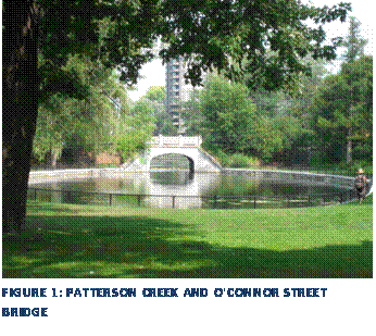
o Relationship with Patterson Creek
and the O’Connor Street bridge
o Its use as a space for passive
recreation
o Rock steps at south west corner of
the district
o Steps to O’Connor Street at the
south east corner of the district
o Steps to Bank Street at the north
west corner of the district
o Banks, fence and rock wall of
Patterson Creek
·
Layout and traditional function of Clemow Avenue as a ceremonial route
connecting to the Queen Elizabeth Driveway via Monkland Avenue
6.0 District
Analysis
Geography
The Glebe neighbourhood is located south of Ottawa’s downtown core, bounded by the Queensway on the north, the Rideau Canal on the east and south and Bronson Avenue to the west. Clemow Estate East is located in the north-eastern section of this neighbourhood. The proposed boundaries for the heritage conservation district are generally defined by Bank Street in the west, Patterson and Clemow Avenues in the north, O’Connor Street in the East and Glebe Avenue in the South. This area was developed on a portion of the land granted to Thomas Fraser circa 1800 and later acquired by George Patterson in 1826.
6.1 Historical Analysis
6.1.1 History of the Glebe
The Glebe was one of the earliest developed neighbourhoods
outside of Ottawa’s urban core as a result of the development of the streetcar
on Bank Street and the Driveway system. The history of the Glebe dates to the
late 18th century but development did not really begin until the
late 19th Century. Clemow
Estate East was one of the large areas of the Glebe beginning to be developed
at the end of the 19th Century through developer speculation on
upper middle class houses. This section
will examine the early history of the Glebe as a whole and then the development
of Clemow Estate East within the overall context of the Glebe.
6.1.2 Rural Settlement
Prior to the creation of Upper Canada in 1791, the land of the present-day Glebe was used for hunting by the Algonquin First Nation. In 1793, after the establishment of Upper Canada, this land, consisting of primeval forest and swamplands, began to be cleared and subdivided for the new Nepean Township in the County of Dundas.[1] The land was surveyed based on rural requirements and regardless of topography, a survey system used throughout the country. The land was laid out in lots and concessions. In the Glebe, Isabella, Glebe, Fifth and Broadway Avenues were bounded by Bronson Avenue to the west and Main Street to the east (prior to the canal) to form one lot.
The first attempt to settle the land was in 1792 by George Hamilton who received a grant of 60,000 acres that he hoped to offer to 100 prospective settlers. By 1797, no land was settled, so the grant was revoked. Hamilton had difficulty settling the land as the soil was mostly sand and glacial till- poor land for farming. In about 1800, Thomas Fraser of Fraserville took up the grant covering most of the Ottawa area and by 1812 had sold the Glebe-area land grants to his sons.[2]
Prior to the construction of the canal, there were no recorded settlers in the area. In 1826, when construction began on the canal, George Patterson, Chief of the Canal Commissariat, purchased Lot G from William Fraser and built a house near the present bank of the Canal and Patterson Avenue. This was the first recorded habitation of the area and his presence remains in the name of Patterson Creek and Patterson Avenue.[3] While building the canal, this area was flooded as far west as Lyon Street and the Queensway. Prior to that, Patterson Creek flowed west of St. Matthew’s Church, through the present church site between Glebe and First Avenues, then northwards to the present termination of Patterson Creek.
In 1836, a 178 acre glebe, running west to east from present day Bronson Avenue to Main Street, and north to south from Glebe to Fifth Avenues, was granted to the Church of Scotland at Bytown.[4] This church later became St. Andrew’s Presbyterian Church at Kent and Wellington in Uppertown. The word “glebe” is derived from the Latin word “gleba,” meaning clod or soil.[5] In the Middle Ages, a glebe in Europe was land belonging to a parish, the revenues from which contributed to the parish’s expenses. A glebe did not perform this function in Canada; instead glebes were land from which churches could earn money through land sales.[6]
Construction on the Rideau Canal began in 1826 under the direction of Lieutenant Colonel John By of the Royal Engineers. The purpose of the canal was to provide access from Montreal to Kingston without having to pass through the possibly hostile American land along the vulnerable St. Lawrence river. Originally designed to route north through Dow’s Lake along Preston Street to join the Ottawa River at Chaudiére Falls, Colonel By rerouted the canal around the Glebe to Bytown and Parliament Hill. With this new route, the south and east boundaries of the present-day Glebe were created. During the building of the canal, Dow’s Swamp was flooded as a result of the St. Louis Dam near Carling Avenue, becoming present-day Dow’s Lake, while a dam erected along the present Echo Drive resulted in flooding of Patterson and Brown’s Inlets as well as along the northeast side of Lansdowne Park. With the final touches completed in the winter of 1831-1832, Colonel John By officially opened the Rideau Canal on May 24, 1832.[7]
6.1.3 Initial Urban Growth
Following the glebe land grant in 1836 to the Church of
Scotland, the land was subdivided and leased until 1875.[8] By 1878, the glebe land east of the canal was
sold and the rest of the land to the west of the canal became known as The
Glebe. Subsequently, the church
subdivided the glebe land into fourteen lots of ten acres each in anticipation
of rising land rents with the influx of civil servants following Ottawa’s
capital designation in 1857.
Unfortunately, land prices didn’t rise until almost thirty years later
following the arrival of the streetcar and the automobile. During the mid-to-late 1800s, the glebe was
not valuable land and there was little farming.
Instead, the land was mostly used for market gardens to supply produce
to the urban dwellers.[9]
The first permanent road to be built through the Glebe was
Bank Street in 1865. Up until 1865, Bank
Street only reached as far as McLeod Street, having moved south as a result of
commerce. But demand for real estate and
interest moved Bank Street south into rural Nepean Township and therefore into
the Glebe. Construction began in 1865 by
William Powell’s Ottawa and Gloucester Macadamized Road Company as a toll road
from McLeod to Farmers’ Bridge, now Billings Bridge and the Billings Estate. At the time, William Powell was a member of
the provincial parliament and by the 1870s, owned the south half of Lot G, from
Patterson to Glebe Avenue. Mutchmor, who
owned the south portion of the Glebe, donated part of his land for the Bank
Street construction. By 1866, Bank
Street crossed Patterson Creek and the canal on wooden bridges, which remained
in use until 1912.[10] Bank Street was
completed in 1868 with a horse-drawn bus service to the Ottawa Agricultural
Society’s fairground, today Lansdowne Park.
Despite being the only road in the Glebe, Bank Street was the primary
force behind the urban development and growth of the neighbourhood.
In the 1870s, the Canada Atlantic Railway was constructed along the present Queensway route.[11] The route was originally a private railway for J. R. Booth’s lumber company to provide connections to New York and Boston and to reach new land east of Georgian Bay. In 1905, the Canada Atlantic Railway became the Grand Trunk Railway and was used to link the main line to Ottawa.
With the expansion of Bank Street, commercial buildings began to appear in the late 1860s and early 1870s. Important commercial buildings of this period included the Grove Hotel, built by William Powell in 1873 in the present day Clemow Estate East area. The stone hotel became a residence in 1891 but was demolished in 1907. By the late 1870s, a depression hit and commercial and residential development in the Glebe slowed until the 1890s, when it was stimulated by three key events.
6.1.4 Urban Growth and Intensification
By the end of the 19th century the Glebe was still a rural community. In 1888, there were only 43 dwellings in the area.[12] An open field stretched between Patterson Avenue, the creek, Bank and Elgin Streets, and most of the area west of Bronson was second-growth forest. However, the arrival of electric streetcars in 1891, the subdivision of the lands east of Bank Street and the construction of the Parkways and park system had a great impact on the pace of urbanization in the Glebe at the end of the 19th and beginning of the 20th centuries
During an economic boom around the turn of the century, one of the first developments of the glebe lands occurred when the land was subdivided into residential lots. Houses were first built on the east side of Bank Street between Glebe and Fifth Avenues, and then continued south of Fifth Avenue on Mutchmor’s land.
The development of electric streetcars was
a catalyst for urban development in North American cities in the late 19th
and early 20th centuries. Prior to the development of streetcar
systems most people were bound to living within walking distance of their
workplace. Streetcars provided the freedom of mobility that allowed people to
live outside of the core of the city but still maintain easy access to the city
centre for work and other amenities. Throughout North America, development of
residential areas followed the streetcar route out of the core of the city.
Many cities saw the development of streetcar suburbs which were isolated areas
of residential development serviced by the streetcar system. These areas are
equivalent to today’s auto-oriented suburbs. In the late 19th
century, the development of the electric streetcar had a massive impact on the
shape of Ottawa and was one of the catalysts for the development of the Clemow
Estate East area.
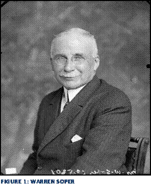
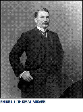
In 1889, the idea of expanding the street car lines to service a larger portion of the city as well as harnessing the new technology of electricity led to the development of the Ottawa Electric Street Railway(OESR). In 1890 the City of Ottawa received a proposal from W.H. Howland, former Mayor of Toronto and president of the Imperial Bank, to build five electric rail lines and have them in operation by 1892. City Council agreed with Howland’s proposal but after months of Howland not being able to fulfill his obligations to provide a guarantee, City Council narrowly (12-10 vote) awarded the contract to local businessmen, Thomas Ahearn and Warren Soper.[13] Soper and Warren were already well known in Ottawa for providing electricity for streetlights from the Ottawa Electric Company power station on Victoria Island, near Chaudiére Falls. [14]
The agreed-upon route extended from the intersection of Rideau Street and Wurtemburg Street west along Rideau Street onto Wellington to O’Connor; south on O’Connor to Albert; west on Albert to Broad and north to the CPR station. The other main lines were to go south on Elgin from Wellington to Catherine; south on Bank from Albert to 100 feet beyond the gate of Lansdowne Park and north from Rideau on either Dalhousie or Cumberland. [15]
A number of other extensions and new services were proposed as well, a full map of the OESR routes can be seen in Figure 3 below. In June 1891, the first electric streetcars ran on four major lines: the Main Line, Bank Street Line, New Edinburgh Line and the Elgin Line.[16] The inaugural run started at the Albert Street Barn and ran out the Bank Street line to Lansdowne Park, the two and a half mile trip took 12 minutes at a top speed of 15 miles per hour. The electric streetcars ran in Ottawa on many different routes until 1959 when the streetcars were stopped and the rails were taken out. [17]
The arrival of the electric streetcar along Bank Street to Lansdowne Park contributed significantly to the development of the Glebe in the early 20th century. The streetcar line provided easy access to downtown and allowed the middle class to live in larger homes on bigger lots.
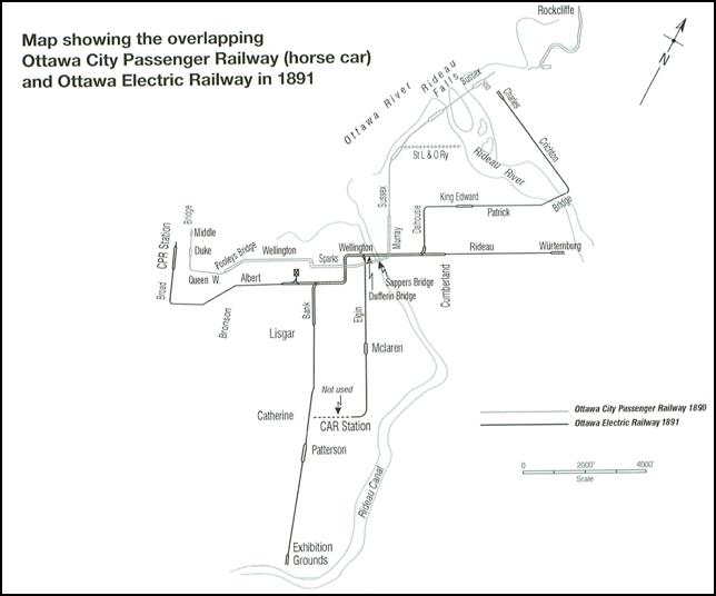
Figure 5: Map of OCPR and OESR Routes in 1891
Frederick Todd’s Plan for the Ottawa Improvement
Commission
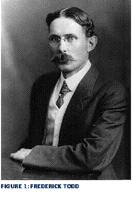 Prime Minister Wilfrid Laurier established the Ottawa Improvement
Commission (OIC) in 1899 to beautify the city and to “create a city worthy of a
capital.”[18] The OIC was given a budget of $60,000 annually and reported
directory to the minister of finance, W. S. Fielding. In 1903 the OIC hired
young landscape architect Frederick G. Todd to prepare a landscaping plan for
the capital. Todd was one of the
earliest landscape architects in Canada, establishing a practice in Montreal in
1900. He was well respected despite his young age as he had worked at office of
Frederick Law Olmstead, America’s premier landscape architect, from 1896 to 1900.
The firm was well known in North America for its work on the Emerald Necklace
series of connected parks in Boston, Central Park in New York City and the
original design of Mount Royal Park in Montreal.[19]
Prime Minister Wilfrid Laurier established the Ottawa Improvement
Commission (OIC) in 1899 to beautify the city and to “create a city worthy of a
capital.”[18] The OIC was given a budget of $60,000 annually and reported
directory to the minister of finance, W. S. Fielding. In 1903 the OIC hired
young landscape architect Frederick G. Todd to prepare a landscaping plan for
the capital. Todd was one of the
earliest landscape architects in Canada, establishing a practice in Montreal in
1900. He was well respected despite his young age as he had worked at office of
Frederick Law Olmstead, America’s premier landscape architect, from 1896 to 1900.
The firm was well known in North America for its work on the Emerald Necklace
series of connected parks in Boston, Central Park in New York City and the
original design of Mount Royal Park in Montreal.[19]
In August of 1903, Todd presented his preliminary plan to the Ottawa Improvement Commission. Todd’s plan called for a federal parkway system to link the Parliament Buildings, the Rideau Canal and the Central Experimental Farm. His plan also called for the development of a series of regional, urban and suburban parks throughout the city. These recommendations and their implementation contributed to the development of the Glebe in the early 20th century.
Todd’s plan recommended that the OIC build a parkway to link the Parliament Buildings with other important areas of the city and to provide a ceremonial drive. However, in the design of the parkways, two major obstacles arose in the Glebe area. The first involved the location of Lansdowne Park with its stables along the canal shoreline, while the second obstacle involved the Fraserfield Lumber and Railway Yard beside Dow’s Lake. [20] In anticipation of a state visit by the Prince of Wales in 1908, the OIC began to build two parkways at once. The first parkway was routed through the middle of Lansdowne Park then across the Dow’s Lake causeway. In 1903, the OIC purchased the backwater at Patterson Creek to build the second parkway. Although the Commission originally intended to use Glebe Avenue, which aligned with the present Carling Avenue for the parkway, the location of the railway yard resulted in Clemow Avenue being used instead. In 1907, the Commission drained and filled the Patterson Creek area to create Central Park and Clemow and Monkland Avenues as part of the parkway system connecting to Parliament, the Experimental Farm and Island Park Drive.[21] Built on fill across Patterson Creek, the Clemow-Monkland Parkway was laid out in urban lots in contrast to the original rural subdivision of the land. Abutting lots were sold, with strict planning controls attached, in which landowners had to submit to design controls by the OIC. The Clemow-Monkland Parkway was planned to be a highly attractive route, especially along Clemow Avenue in the Clemow Estate East area, where wide boulevards were created and planted with American elm trees.
The parkway through Lansdowne Park existed until 1926. As the Clemow-Monkland Parkway could never be a true parkway, as it did not lead anywhere, the successors of the OIC, the Federal District Commission and National Capital Commission tried to rid itself of the responsibilities for the Clemow-Monkland Parkway. With the expansion of the electric streetcars along Bank Street, the subdivision of the glebe lands, and the creation of the Parkways along the canal, this suburban community quickly grew during the first half of the 20th Century.
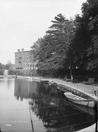
6.1.5 Development of Central Park
 Central Park was one of the first district parks created by the
Ottawa Improvement Commission (OIC) in the early 20th Century. A large component of Frederick Todd’s 1903
report to the OIC was a proposed regional parks system comprised of regional
parks, suburban parks and district parks. Todd’s plan echoed the City Beautiful
planning theory popular in the early 20th century. The plan called
for the development of parks and open spaces for their “mental, physical and
moral” benefits[22]. Consistent with the theory of the time, Todd felt that access to a
variety of open spaces (from large natural parks or reserves to city parks and
squares) would be beneficial not only to the citizens of Ottawa but it would be
befitting of a capital city.[23] These late Victorian ideas
about parks were echoed in Todd’s report,
Central Park was one of the first district parks created by the
Ottawa Improvement Commission (OIC) in the early 20th Century. A large component of Frederick Todd’s 1903
report to the OIC was a proposed regional parks system comprised of regional
parks, suburban parks and district parks. Todd’s plan echoed the City Beautiful
planning theory popular in the early 20th century. The plan called
for the development of parks and open spaces for their “mental, physical and
moral” benefits[22]. Consistent with the theory of the time, Todd felt that access to a
variety of open spaces (from large natural parks or reserves to city parks and
squares) would be beneficial not only to the citizens of Ottawa but it would be
befitting of a capital city.[23] These late Victorian ideas
about parks were echoed in Todd’s report,
“…large areas of untamed forest which can be set aside forever for the enjoyment of people who wish to get away for a day from the crowded city, who wish to wander in the woods where the wildest birds are at home, and where nature’s mossy carpet is still luxuriant and unworn?”[24]
 Development of “Patterson Creek Park” was part of Todd’s 1903 plan
(see Figure 6). While Todd was not employed to implement his
plan in the years following his report, the Patterson Creek area was acquired
by the OIC and Central Park was ultimately completed in 1912 becoming one of
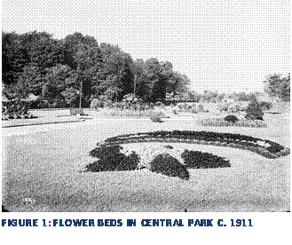
the first completed parks in Todd’s plan.
Instead of following Todd’s concept of maintaining the natural beauty of
Patterson Creek, however, the OIC walled in the creek, filled it in west of
O’Connor Street and planted Central Park with formal flowerbeds and
pathways. The OIC faced serious
criticism for its implementation of Todd’s 1903 Plan. In comments regarding
Central Park, Ottawa architect and OIC Commissioner Colbourne Meredith noted
that “everything had been done as it should not be done.”[25]
Development of “Patterson Creek Park” was part of Todd’s 1903 plan
(see Figure 6). While Todd was not employed to implement his
plan in the years following his report, the Patterson Creek area was acquired
by the OIC and Central Park was ultimately completed in 1912 becoming one of
the first completed parks in Todd’s plan.
Instead of following Todd’s concept of maintaining the natural beauty of
Patterson Creek, however, the OIC walled in the creek, filled it in west of
O’Connor Street and planted Central Park with formal flowerbeds and
pathways. The OIC faced serious
criticism for its implementation of Todd’s 1903 Plan. In comments regarding
Central Park, Ottawa architect and OIC Commissioner Colbourne Meredith noted
that “everything had been done as it should not be done.”[25]
 6.1.6 Development of Clemow Estate east
Clemow
Estate East was one of several areas developed in the early 20th
century in the Glebe. The area is a good example of developer speculation and
the sale of a lifestyle as was typical of suburban development of this time.
The upper middle class were looking for the pastoral setting of the country
with the convenience of accessibility and proximity to the core of the city for
employment and other amenities.
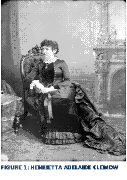
There were three key players in the early development of the residential area surrounding Central Park: the developers, Henrietta Adelaide Clemow[26] and her cousin William Powell and Werner E. Noffke, the architect they engaged to design a number of houses throughout the district including its most significant landmarks.
Henrietta A. Clemow was the daughter of the Honourable Senator Francis Clemow for whom Clemow Avenue is named. Senator Francis Clemow was born in Trois Rivières, Québec in 1821. Clemow came to Bytown in 1841 and soon began work as a journalist and founded the paper “The Monarchist. “ He later moved onto other ventures including business manager and later president of the Ottawa Gas Works.[27] He was appointed to the Senate by Sir John A. Macdonald in 1885 and served as a Conservative senator until his death in 1902. As the only heir, (Clemow’s only son, Francis died young), Miss Henrietta “Ada” Clemow inherited the Clemow Estate after her father’s death in 1902. At the time, much of the area included in the Heritage Conservation District remained undeveloped. Clemow’s well-known cousin, William F. Powell became the manager of the estate and guided its development. Interestingly, Henrietta Clemow stayed involved in the work, which was unusual for a woman at this time.
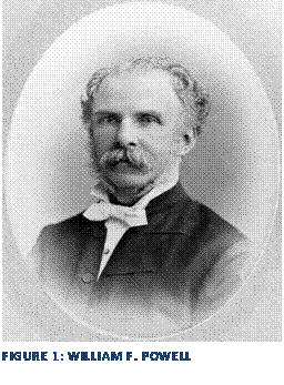 William Powell also inherited land in the area from his father,
William F. Powell Senior[28]. William Powell
Snr. was a Conservative member of the Legislative Assembly from 1854-1866. He
owned much of the area north of the glebe lands and east of Bank Street upon
his death in 1889. William Powell was also well-known in Ottawa at the end of
the 19th century, with his most prominent role as the chief of the Ottawa
Police. Appointed to the position in 1896, Powell dramatically changed the way
the force operated by instituting better documentation methods, establishing
bicycle patrols and a patrol wagon, He also required the officers to wear
presentable uniforms and participate in an exercise program. Powell’s reforms
influenced the management of the police force until the Second World War.[29]
William Powell also inherited land in the area from his father,
William F. Powell Senior[28]. William Powell
Snr. was a Conservative member of the Legislative Assembly from 1854-1866. He
owned much of the area north of the glebe lands and east of Bank Street upon
his death in 1889. William Powell was also well-known in Ottawa at the end of
the 19th century, with his most prominent role as the chief of the Ottawa
Police. Appointed to the position in 1896, Powell dramatically changed the way
the force operated by instituting better documentation methods, establishing
bicycle patrols and a patrol wagon, He also required the officers to wear
presentable uniforms and participate in an exercise program. Powell’s reforms
influenced the management of the police force until the Second World War.[29]
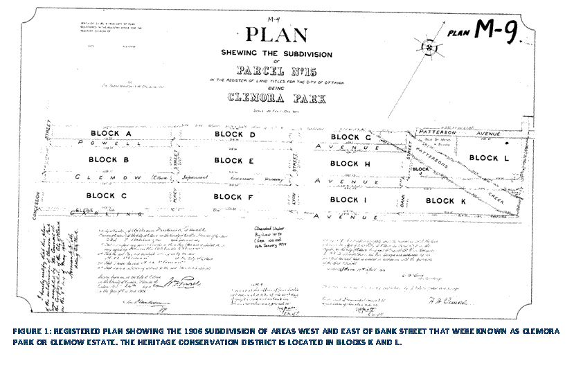
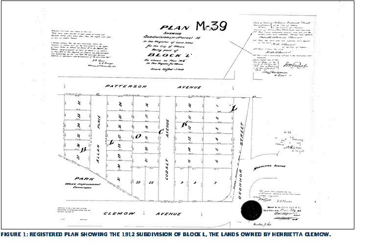
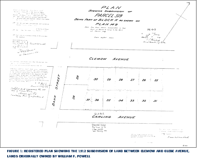
Henrietta Clemow and William Powell formed Clemow-Powell Realty (later Clemora Realty) to develop the large area of land they owned at the north end of the Glebe. The Ottawa Improvement Commission drained their land in the process of developing the Driveways and the area was ready for development in the early part of the 20th century.[30] Powell and Clemow subdivided the lands beginning in 1906 with the subdivision of the land between Patterson Avenue and Glebe Avenue (then Carling Avenue) west of Bank Street to create “Clemora Park” (see Figure 10). Later, in 1912, Clemow and Powell subdivided their land on the east side of Bank Street, between Glebe Avenue and Clemow Avenue. This later subdivision surrounding Patterson Creek Park was the eastern portion of Clemow Estate that is included in the Heritage Conservation District. (See Figure 11) The area was developed as an upper-middle class suburb with impressive houses flanking the pastoral Central Park and Patterson Creek. Soon after subdividing, Clemow-Powell Realty engaged local architect W. E. Noffke to build a number of the houses in the area. There are 10 houses designed by Noffke in the District and at least one other that is likely a Noffke design.
Werner Ernst Noffke
Werner Ernst Noffke remains one of Ottawa’s most prolific 20th century architects, practicing in the city from 1901 until 1960 . There are many examples of Noffke’s work remaining throughout Ottawa and as Harold Kalman notes in his catalogue of Noffke’s works:
“One can be born in a Noffke hospital,
educated in a Noffke school, married in a Noffke church, work in a Noffke
office, live in a Noffke house, and be put to rest in a Noffke funeral chapel.[31]”
 Noffke was known as a very versatile architect who was open to new
ideas and styles. It has been noted that this openness was “undoubtedly one of
the factors in the success of Noffke’s practice.” [32]
Noffke was known as a very versatile architect who was open to new
ideas and styles. It has been noted that this openness was “undoubtedly one of
the factors in the success of Noffke’s practice.” [32]
W.E. Noffke was born in Stolp (now Poland)
in 1878 and in 1883 the Noffke family immigrated to Ottawa. Upon arrival in
Canada, the Noffke family became strongly associated with the small, but
growing German community in the city.[33] Noffke’s interest and training in architecture began early, at a
time before the profession was formalized. As a teenager, Noffke apprenticed
with local architect Adam Harvey and later pursued night study at the Fine Arts
Association of Ottawa. In 1896, Noffke began working in the office of Moses
Chamberlain Edey as a draftsman. Apart from his on-the-job experience with
Edey, Noffke also made a series of contacts with future clients including
William Powell. Noffke set up a practice
in association with George Northwood of Winnipeg in 1901. Many of Noffke’s
early projects were the result of his early work in 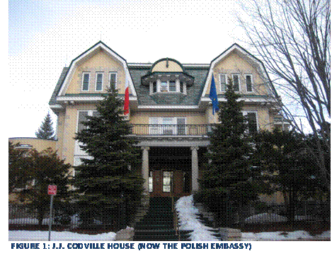 the office of Moses Edey including an early project for a “six
tenement block” for Mr. A. Sparks. [34]
the office of Moses Edey including an early project for a “six
tenement block” for Mr. A. Sparks. [34]
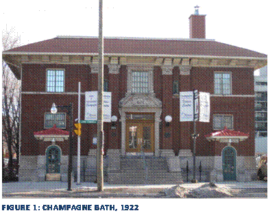
In Noffke’s early years he favoured the trend in domestic architecture of the time and built primarily large brick houses mixing classical elements with the Queen Anne Revival style. Noffke’s first major domestic commission came in 1907 from John J. Codville for a large home at the east end of Daly Avenue near the Rideau River. Evidence of Noffke’s non-domestic work remains throughout Ottawa, including the Central Ottawa Post Office, built in 1938 combining elements of the Château style and the art deco style in this corner stone of Sparks Street. Noffke also designed the Champagne Bath in 1922, which exhibits elements of the Spanish Revival style for which he later became so well known. The final entry in Noffke’s job book was in 1960 when he was 82 years of age. Noffke died four years later at 86.
 The Clemow Estate development was likely Noffke’s largest
undertaking in domestic architecture.[35] He was contracted by William
Powell in 1913 to begin development of the Clemow Estate area surrounding
Central Park and Patterson Creek. He was contracted to build five houses in
1913. It was in this development that Noffke began to truly show his penchant
for the Spanish Colonial style, which would later become known as his
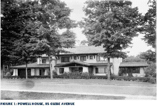
favourite. The house he designed for William Powell at 85 Glebe Avenue in 1913
is a fine example of this style and is a landmark in the Heritage Conservation
District. Noffke’s version of the Spanish Colonial Revival style also
illustrates his appreciation for the North American bungalow and Frank Lloyd
Wright’s Prairie Style as well as the architecture of Wright’s local student,
Francis Sullivan. [36] Noffke’s involvement in the Clemow Estate development seemed to
progress after the 1913 contract to individual houses for specific clients
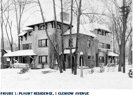
including the Plaunt Residence at 1 Clemow Avenue in 1915. Noffke continued to
design houses in Clemow Estate up until 1927.
The Clemow Estate development was likely Noffke’s largest
undertaking in domestic architecture.[35] He was contracted by William
Powell in 1913 to begin development of the Clemow Estate area surrounding
Central Park and Patterson Creek. He was contracted to build five houses in
1913. It was in this development that Noffke began to truly show his penchant
for the Spanish Colonial style, which would later become known as his
favourite. The house he designed for William Powell at 85 Glebe Avenue in 1913
is a fine example of this style and is a landmark in the Heritage Conservation
District. Noffke’s version of the Spanish Colonial Revival style also
illustrates his appreciation for the North American bungalow and Frank Lloyd
Wright’s Prairie Style as well as the architecture of Wright’s local student,
Francis Sullivan. [36] Noffke’s involvement in the Clemow Estate development seemed to
progress after the 1913 contract to individual houses for specific clients
including the Plaunt Residence at 1 Clemow Avenue in 1915. Noffke continued to
design houses in Clemow Estate up until 1927.
6.2 Architectural
Analysis
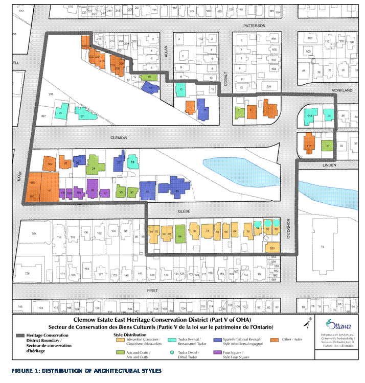
The District features a wide variety of architectural styles that were typical of Ottawa neighbourhoods in the late 19th and 20th centuries. In particular, the Edwardian, Arts and Crafts and Spanish Colonial Revival styles are the most dominant. (See Figure 14- Map of style distribution). A brief description of these styles and how they were typified in Clemow Estate East is outlined below.
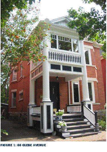
66 Glebe Avenue is a
good example of Edwardian Classicism as it appeared in Clemow Estate East. Most
of the Edwardian style buildings in the district are clustered along the south
side of Glebe Avenue. 66 Glebe Avenue was constructed in 1911 for Charles Lough
and is a good representation of the large, yet simple houses built during this
era. The house is two and a half storeys and rectangular in plan with a hipped
roof. There is an intersecting gable at the front of the house and a plain
cornice, dentil moulding and frieze. The house features a typical side hall
plan with a classically inspired two-storey porch with full length fluted,
ionic columns and a front gable roof.
The upper storey porch was closed in at some point.
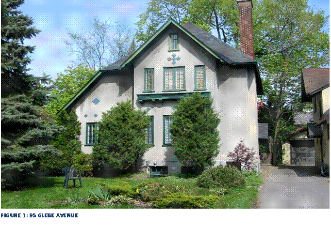
This two-storey stucco clad house has an irregular floor plan and an asymmetric roof and is oriented perpendicular to the street with the main entrance at the side of the house. This version of the Arts and Crafts style is clearly inspired by the English Country cottage as seen in the large brick chimney, multi-pane casement windows and the pastoral setting of the house in the landscape of mature coniferous trees in the front yard and backing onto Central Park.
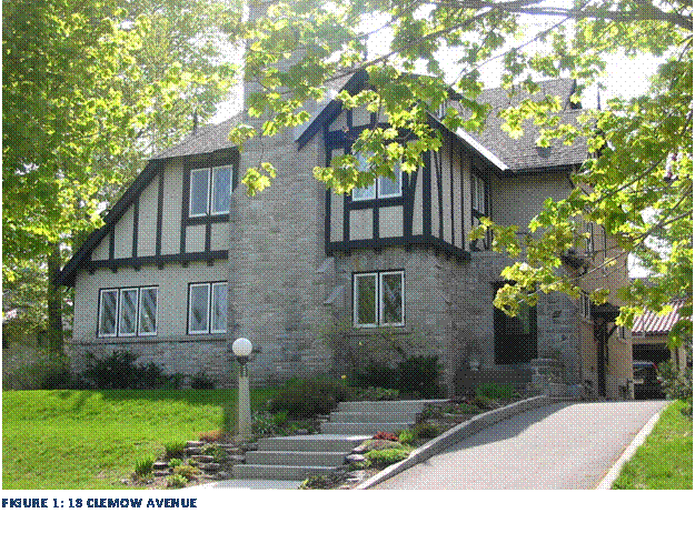
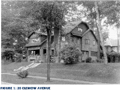
18 Clemow Avenue was built in 1923 by architect W.E. Noffke and is a good example of the Tudor Revival style in Clemow Estate East. Easily distinguishable as Tudor Revival by its mock-Tudor half timbering, 18 Clemow Avenue features other typical features of the style including the large central stone chimney, stucco and stone cladding and leaded glass casement windows.
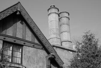
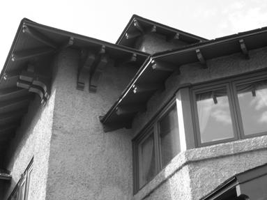
Spanish Colonial Revival
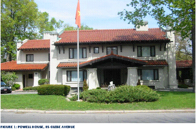
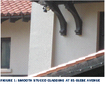
The Powell House located at 85 Glebe Avenue is an excellent example of Spanish Colonial Revival in Ottawa. The use of a smooth stucco finish to imitate adobe and the red clay tile roof are key elements of this style. The house also features buttressed piers at the corners of the house and the porte-cochère that straddles the circular driveway. The large eaves brackets and exposed rafter tails are also typical of this style.
6.3 Cultural Landscape
 Clemow Estate East is a distinct cultural landscape comprised of the
ecclectic mix of housing styles, early 20th century street pattern with
a particular focus on Central Park. The houses along Clemow Avenue have a close
relationship to Central Park. Clemow Avenue has been closed to through traffic since
the 1970s and the street is quiet. The layout of the houses addresses the park as
well as the streetscape. For instance, 18 Clemow Avenue fronts onto Clemow
Avenue and Central Park, but the park is also located to the immediate east of
the property. The siting and landscaping of the lot provides a smooth
transition between public and private space. There is no large fence separating
the property from the park, mature trees and shrubs provide a soft division
between the two spaces. Similarly, newer
development in the district recognizes the importance of the park. The houses
at 206-226 Patterson Avenue all address and provide linkages to the park.
Clemow Estate East is a distinct cultural landscape comprised of the
ecclectic mix of housing styles, early 20th century street pattern with
a particular focus on Central Park. The houses along Clemow Avenue have a close
relationship to Central Park. Clemow Avenue has been closed to through traffic since
the 1970s and the street is quiet. The layout of the houses addresses the park as
well as the streetscape. For instance, 18 Clemow Avenue fronts onto Clemow
Avenue and Central Park, but the park is also located to the immediate east of
the property. The siting and landscaping of the lot provides a smooth
transition between public and private space. There is no large fence separating
the property from the park, mature trees and shrubs provide a soft division
between the two spaces. Similarly, newer
development in the district recognizes the importance of the park. The houses
at 206-226 Patterson Avenue all address and provide linkages to the park.
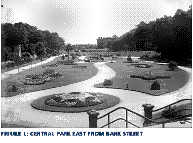
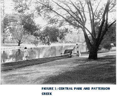
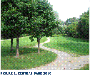
Central Park itself is the heart of the cultural landscape of this area and is one of the first district parks developed by the Ottawa Improvement Commission in the early 20th century. Designed as a space for quiet and passive recreation, the park retains this use today. The existing pathway layout and the mature trees of the park are significant elements that contribute to the area’s sense of place. The park is bisected by Clemow Avenue, and the two sections provide a slightly different landscape. The section of the park south east of Clemow Avenue includes Patterson Creek inlet and provides a treed waterside setting for peaceful recreation while the north side of the park provides a more manicured park featuring winding pathways and green lawns.
The layout of the
Clemow Estate East district in relation to Central Park itself is also integral
to the heritage value of the District. With many of the houses fronting or
backing onto the Park there is a blending of the public and private realms
where property lines meet the park and through landscaping features. The
association with Central Park is important in conveying the context of this
area. Central Park is not only a
landmark for this enclave but also for the Glebe as a whole. The Park is an
important example of the 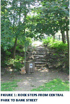 development of district parks in Ottawa as one
of the first parks developed by the OIC.
The aggregate and globe light standards along Clemow Avenue are an
important reminder of the work of the OIC.
development of district parks in Ottawa as one
of the first parks developed by the OIC.
The aggregate and globe light standards along Clemow Avenue are an
important reminder of the work of the OIC.
 The streetscape of Clemow Estate East features
two main streets, Glebe Avenue and Clemow Avenue. Both streets are quiet with
mainly local traffic on Glebe Avenue and Clemow Avenue. Front yards are
generally small and landscaped with small lawns, mature trees and flower beds
or rock gardens. Fences were not typical in this area and thus there is often
an unbroken transition between the public space of the park and the private
space of the garden.
The streetscape of Clemow Estate East features
two main streets, Glebe Avenue and Clemow Avenue. Both streets are quiet with
mainly local traffic on Glebe Avenue and Clemow Avenue. Front yards are
generally small and landscaped with small lawns, mature trees and flower beds
or rock gardens. Fences were not typical in this area and thus there is often
an unbroken transition between the public space of the park and the private
space of the garden.
7.0 Heritage Conservation District Guidelines
These guidelines are meant to supplement existing policy documents (Official Plan, Ontario Heritage Act) and to specifically address the heritage character of Clemow Estate East. All projects undertaken using these guidelines should also conform to the City Council- approved “Standards and Guidelines for the Conservation of Historic Places in Canada”[37] as amended from time to time.
Heritage
Alteration Permits
All properties located in the District are designated under Part V of the Ontario Heritage Act and as such significant alterations to the property require an application for a Heritage Alteration Permit. This permit application must be approved by City Council prior to issuance. City staff will use the guidelines contained in this section to assess and evaluate all applications to alter properties located in the heritage conservation district. Minor alterations do not require a heritage alteration permit and are described in Section 2.8.
Design
Guidelines
These design
guidelines are meant to ensure the conservation of the individual heritage
resources as well as the overall character of the Clemow Estate East district.
These guidelines will be used to evaluate development proposals for alterations
or additions to existing buildings or new infill development. The guidelines
are divided into three primary sections:
1. Guidelines for contributing buildings of cultural heritage value
2. Guidelines for cultural landscapes
3. Guidelines for new infill development in the heritage district.
Objectives
· Buildings of cultural heritage value will be retained, protected and enhanced through ongoing restoration and maintenance.
· The cultural landscape of Clemow Estate East will be protected and retained through the preservation of the historic street pattern, retention of mature trees and the preservation and enhancement of public spaces such as Central Park.
· New infill development will be in a contemporary style that complements and enhances the character of the district.
Those buildings ranked as categories 1 through 3 are considered to be “contributing buildings” in the district. These buildings contribute to the overall heritage character and value of the district. Buildings ranked as category 4 are considered to be “non-contributing” buildings in the district and do not contribute to the overall heritage value of the district.
|
Address |
Status |
Address |
Status |
Address |
Status |
|
1 Clemow
Avenue |
Contributing |
50 Glebe Avenue |
Contributing |
97 Glebe Avenue |
Contributing |
|
5 Clemow
Avenue |
Non-Contributing |
52 Glebe Avenue |
Contributing |
99 Glebe Avenue |
Contributing |
|
7 Clemow
Avenue |
Contributing |
54 Glebe Avenue |
Contributing |
101 Glebe Avenue |
Contributing |
|
11 Clemow
Avenue |
Contributing |
58 Glebe Avenue |
Contributing |
103 Glebe Avenue |
Contributing |
|
15 Clemow
Avenue |
Contributing |
64 Glebe Avenue |
Contributing |
105 Glebe Avenue |
Contributing |
|
18 Clemow
Avenue |
Contributing |
66 Glebe Avenue |
Contributing |
117 Glebe Avenue |
Non-
Contributing |
|
20 Clemow
Avenue |
Contributing |
68 Glebe Avenue |
Non-Contributing |
683 Bank Street |
Non-Contributing |
|
24 Clemow
Avenue |
Contributing |
74 Glebe Avenue |
Contributing |
685-697 Bank Street |
Non-Contributing |
|
26 Clemow
Avenue |
Contributing |
80 Glebe Avenue |
Contributing |
517 O’Connor Street |
Contributing |
|
27 Clemow
Avenue |
Contributing |
84 Glebe Avenue |
Contributing |
550 O’Connor Street |
Contributing |
|
28 Clemow
Avenue |
Contributing |
85 Glebe Avenue |
Contributing |
515 O’Connor Street |
Contributing |
|
29 Clemow
Avenue |
Contributing |
89 Glebe Avenue |
Non-Contributing |
38 Monkland Avenue |
Contributing |
|
206-226
Patterson Avenue |
Non-Contributing |
88-90 Glebe Avenue |
Contributing |
12 Cobalt Place |
Non-Contributing |
|
10 Allan
Place |
Non-Contributing |
93 Glebe Avenue |
Contributing |
37 Linden Terrace |
Contributing |
|
12 Allan
Place |
Contributing |
92-94 Glebe Avenue |
Contributing |
|
|
|
15 Allan
Place |
Contributing |
95 Glebe Avenue |
Contributing |
|
|
7.1 General Guidelines for Contributing
Buildings
7.1.1 Conservation and Maintenance
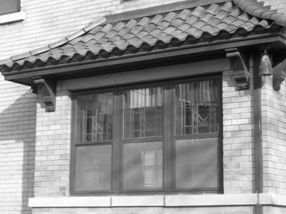
These guidelines strongly encourage the conservation, restoration and ongoing maintenance of the character defining elements of contributing buildings within the Clemow Estate East Heritage Conservation District. The overall aim of these guidelines is to ensure that original material is retained wherever possible and any replacement of material is appropriate and sympathetic to the heritage character of the building.
![]()
· The restoration of Spanish tile or cedar shingle roofing is encouraged where there is evidence that this type of material was originally used.
· If asphalt shingles are used, they should be chosen in a colour sympathetic to the character of the original building
· Chimneys should be retained and maintained. If not in use, chimneys should be retained and capped.
· Original rooflines (gable, hip, gambrel, flat etc) should be maintained.
Cladding
·
 The retention and restoration of original cladding is strongly
encouraged. If cladding must be replaced, it should be replaced in-kind.
The retention and restoration of original cladding is strongly
encouraged. If cladding must be replaced, it should be replaced in-kind.
· Modern cladding in contemporary materials (ie. vinyl or aluminum) will not be approved.
· Cleaning of brick and stone buildings should be undertaken using gentle and non-abrasive methods. Sand blasting is not an appropriate method to clean brick or stone.
· Repointing of brick and stone buildings in the district should be undertaken with care to ensure proper lime-based mortars are used in the repointing process.
Windows & Doors
·
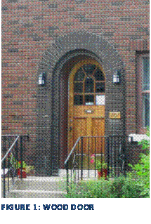 Original wood windows, storm windows and doors should be retained
and restored wherever possible.
Original wood windows, storm windows and doors should be retained
and restored wherever possible.
· Original leaded and stained glass windows should be retained and restored wherever possible.
· The installation of replacement windows and doors in contemporary materials (ie. vinyl or metal) and styles will not be permitted. Energy efficiency can be achieved with existing windows and doors through the restoration of the windows and the installation of weather stripping and appropriate wooden storm windows.
·
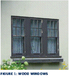 If replacing some or all of the original windows on a building
becomes necessary, replacement windows must be based on original windows.
Replacement windows must match the materials, shape, size, and muntin profile
of the original windows. Where no documentary evidence of the original windows
exists, replacement windows should be based on local examples in similar houses
as opposed to falsely replicating windows to evoke a particular historic style.
If replacing some or all of the original windows on a building
becomes necessary, replacement windows must be based on original windows.
Replacement windows must match the materials, shape, size, and muntin profile
of the original windows. Where no documentary evidence of the original windows
exists, replacement windows should be based on local examples in similar houses
as opposed to falsely replicating windows to evoke a particular historic style.
Porches
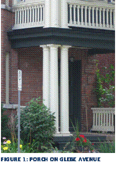
· Porches should be conserved and maintained including decorative elements such as railings and balusters. Any replacement elements should replicate the original.
· If a property owner wishes to reinstate a missing porch, the design should be based on documentary evidence (ie. historic photographs). If no such evidence exists, the porch should take cues from other local examples on similar buildings.
· If changes to railing heights are required to meet the standards of the Building Code, additions should be made to existing railings in the form of a contrasting but sympathetic horizontal railing.
· Restoration of porches should use appropriate materials for all elements. For instance, replacing wood columns with fiber glass columns in not an appropriate intervention.
|
|
|
Decorative Elements
· Decorative architectural features that contribute to the heritage value of the building should be restored and retained wherever possible.
· Decorative wood elements should be maintained on an ongoing basis to ensure that areas of water penetration are found and repaired.
Public Spaces & Streetscaping
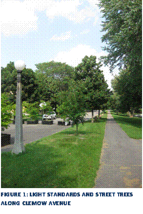
· Historic light standards should be maintained and conserved throughout the district but with particular reference to those areas facing onto Central Park.
· The open spaces of Central Park and Patterson Creek will be conserved as cultural heritage landscapes representing an important era of development in the Glebe and Ottawa as a whole.
· Alterations to the existing walkways, landscaping and other features of Central Park will be sensitive to the historic landscape of the park and will require a Heritage Alteration Permit.
· New development should be sympathetic to the nature of open space in the district with appropriate setbacks and landscaping.
·
Mature street trees and
sidewalks are essential to the character of the district and should be
protected.
· The historic street pattern around Central Park and Patterson Creek should be maintained to conserve the cultural landscape of a developer driven suburb and the history of the Clemow-Monkland Parkway.
7.1.2 Alterations and Additions to Contributing
Buildings
·
 Alterations and additions to contributing buildings should be
sympathetic to the existing building, subordinate to, and distinguishable from
the original. Historicism or falsifying a past architectural style in a new
addition is strongly discouraged.
Alterations and additions to contributing buildings should be
sympathetic to the existing building, subordinate to, and distinguishable from
the original. Historicism or falsifying a past architectural style in a new
addition is strongly discouraged.
· All new additions to contributing buildings should respect the character defining elements of the individual building as well as the heritage attributes of the district as a whole.
· The height of any addition to an existing building should not exceed the height of the existing roof slope.
· Using other contributing buildings in the District and the building concerned as a guide, alterations and additions should be consistent with respect to size, scale and massing but should be designed in a contemporary manner.
· New additions should respect the existing wall to window ratio and proportion of the existing building.
· New dormers, skylights, solar panels or other roof top structures should be located on the rear slope of the roof.
7.1.3 Private Landscaping
· Houses in Clemow Estate East are generally set back from the street small, unfenced front yards. The preservation of existing landscaping and mature trees is strongly encouraged.
· Planting of new trees is encouraged. New trees should be deciduous species that develop a broad overhanging leaf canopy.
·
 Mature trees on private lots should be maintained, especially on the
north side of Glebe Avenue and the south side of Clemow Avenue where private
space and the public space of Central Park blend together.
Mature trees on private lots should be maintained, especially on the
north side of Glebe Avenue and the south side of Clemow Avenue where private
space and the public space of Central Park blend together.
· Front yards in Clemow Estate East did not historically have fencing and such fencing will be discouraged.
· The Urban Tree Conservation By-law requires that any person wishing to cut down a distinctive tree (a tree with a trunk diameter of 50cm or greater) must first obtain a distinctive tree permit from the City.
· The creation of new front yard parking spaces will not be permitted.
7.2 Guidelines
for Infill in the Heritage Conservation District
These guidelines were developed to assist property owners, architects, planners, developers and community groups in developing and assessing new infill projects within the Heritage Conservation District. These guidelines provide direction for sensitive and contextual infill that will contribute to rather than detract from the heritage attributes of the Heritage Conservation District.
7.2.1 New Buildings
· New buildings should contribute to and not detract from the heritage character of the District.
· New buildings should be designed to be compatible with the District’s contributing buildings in terms of scale, massing, height, setback, entry level, materials, and fenestration patterns.
· The roof profile and the location of the eaves lines or the roof parapet should be designed so that the apparent height and form of the roof is compatible with that of the immediate neighbours and the streetscape as a whole.
· Integral garages and below grade entrances are not permitted.
· The ground floor elevations of new construction should be designed so its height above grade is compatible with that of the streetscape.
7.3 Alterations Not Requiring a Heritage Permit
The following are minor alterations that do
not require a Heritage Alteration Permit under the Ontario Heritage Act:
· Interior alterations
· Painting/paint colour
· Regular on-going building maintenance such as repointing, a new roof and foundation repairs.
· Repair, using the same materials, of existing features including roofs, exterior cladding, cornices, brackets, columns, balustrades, porches and steps, entrances, windows, foundations and decorative wood, metal or stone.
· Minor alterations to the rear of the building.
· Alterations to soft landscaping
7.4 Heritage Permits Issued by City Staff
Section 42 (16) of the Ontario Heritage Act states that:
“The council of a municipality may delegate by by-law its power to grant permits for the alteration of property situated in a heritage conservation district designated under this part to an employee or official of the municipality…”
In the Clemow Estate East Heritage Conservation District, City staff is authorized to issue heritage permits on behalf of City Council when the proposed work is compatible with the guidelines outlined in this Plan. Applicants are encouraged to meet with a heritage planner regarding proposed work prior to making a formal application. This pre-consultation will assist in informing both the heritage planner and the applicant about the proposal, additional requirements of changes and help to expedite the process once an application is formally submitted. At this point, the applicant may also be advised of other required planning processes (i.e. Site Plan Application).
In the following circumstances, and at the discretion of the Heritage Planner, City Council approval of a heritage permit will be required:
· Construction of new buildings in the District
· Projects that do not conform with the guidelines outlined in the Plan.
· Alterations to the landscape of Central Park
8.0 BIBLIOGRAPHY
Burgess, Wayne F.
“Glebe To Have Neighbourhood-Wide 40 km/h Speed Limit!” Glebe
Community Association Noticeboard.
[http://www.theglebeonline.com/gca/register/index.html]. 29 Oct. 2003.
Farr, D. M. L. A Church in the Glebe: St. Matthew's,
Ottawa, 1898-1988: a history prepared for the occasion of the 90th anniversary
of St. Matthew's Church. St. Matthew's Anglican Church, Ottawa: 1988.
Gordon, David L.A. “Frederick G. Todd and the Origins of the
Park System in Canada’s Capital.” Journal of Planning History. 2002:1,
pp. 29-57
Kalman, Harold and Mackie, Joan. The Architecture of W.E.
Noffke. Heritage Ottawa, 1976.
Leaning, John. The Story of the Glebe. M.O.M.
Printing: October 1999.
Lewis, Al. The Glebe: Evolution of an Ottawa
Neighbourhood.
[http://www3.sympatico.ca/ag.lewis/glebe.htm]. November 2002.
Marsh, James H. “Building the Rideau Canal.” The Canadian Encyclopedia. Historica Foundation of Canada: 2004.
McKeown, Bill. Ottawa’s Streetcars. Railfare Books: Pickering.
2004
Meredith, Colbourne. Annotated Version of Frederick Todd’s “Preliminary Report to the Ottawa Improvement Commission.” 1913
Merriam-Webster’s Collegiate Dictionary, Tenth
Edition. Merriam-Webster,
Incorporated: 2002.
OC Transpo. “History of Public Transit in Ottawa.”
http://www.octranspo.com/about_main_696.htm
Ottawa Collegiate Ex-Pupils Association. A History of the
Ottawa Collegiate Institute, 1843-1903. The Mortimer Company Limited, 1904.
Ricketts, Shannon. W.E. Noffke: an Ottawa Architect.
Master’s Research Paper, Carleton University 1990.
Taylor, John. Ottawa: An Illustrated History. James
Lorimer & Company, 1986.
Taylor, John. (1989). “City Form and Capital Culture:
Remaking Ottawa.” Planning Perspectives. 4:1 pp. 79-105.
Todd, Frederick. Preliminary Report to the Ottawa
Improvement Commission. August 1903.
9.0 Figure
References
1.
City of
Ottawa
2. Library and Archives Canada. Online MIKAN no. 3212679
3.
Library and Archives Canada.
Online MIKAN no. 3261568
4.
McKeown, Bill. Ottawa’s
Streetcars. Railfare Books: Pickering. 2004
5.
Todd, Frederick. “Preliminary
Report to the Ottawa Improvement Commission.” August 1903
6.
Frederick
Todd, 1909. McCord Museum, W. Notman and Sons Collection. II175018
7. William James Topley Studio Fonds. Library and Archives Canada. PA-010130
8.
William
James Topley Studio Fonds. Library and
Archives Canada. PA-013015
9. William James Topley Studio Fonds. Library and Archives Canada. 3202955
10. William James Topley Studio Fonds. Library and Archives Canada. 3240295
11. City of Ottawa
12. William James Topley Studio Fonds. Library and Archives Canada. 3318896
13. City of Ottawa R-Plan
14. City of Ottawa R-Plan
15. City of Ottawa R-Plan
16. City of Ottawa, Planning and Growth Management Department.
17. City of Ottawa, Planning and Growth Management Department.
18.
Canada.
Dept. of Interior / Library and Archives Canada / PA-03433
19.
Canada.
Dept. of Interior / Library and Archives Canada / PA-034349
20.
Canada.
Dept. of Interior / Library and Archives Canada / PA-034338
21. City of Ottawa, Planning and Growth Management Department.
22. City of Ottawa, Planning and Growth Management Department.
23. City of Ottawa, Planning and Growth Management Department.
24. City of Ottawa, Planning and Growth Management Department.
25. City of Ottawa, Planning and Growth Management Department.
26. City of Ottawa, Planning and Growth Management Department.
27. City of Ottawa, Planning and Growth Management Department.
28. City of Ottawa, Planning and Growth Management Department.
29. City of Ottawa, Planning and Growth Management Department.
30. City of Ottawa, Planning and Growth Management Department.
31. City of Ottawa, Planning and Growth Management Department.
32. City of Ottawa, Planning and Growth Management Department.
33. City of Ottawa, Planning and Growth Management Department.
34. City of Ottawa, Planning and Growth Management Department.
35. City of Ottawa, Planning and Growth Management Department.
36. City of Ottawa, Planning and Growth Management Department.
37. City of Ottawa, Planning and Growth Management Department.
38. City of Ottawa, Planning and Growth Management Department.
39. City of Ottawa, Planning and Growth Management Department.